

Mori Atlas logo
National parkSapo National Park

Discover the mapped boundaries and geographic context of this protected natural landscape.

Sapo National Park: Liberia's Premier National Park Landscape in Sinoe County

Sapo National Park stands as a significant protected natural area within Liberia, specifically located in Sinoe County. As a national park, its designation signifies a commitment to preserving its geographic identity and landscape features. This page offers detailed map context, enabling a clear understanding of Sapo National Park's protected boundaries and its place within the regional geography, supporting structured atlas exploration.

tropical rainforestbiodiversity hotspotnational parkWest Africaprimary forestprotected area

Sapo National Park

National park

Park overview

Structured park overview, official facts, and landscape profile for Sapo National Park

Sapo National Park park facts, protected area profile, and essential visitor context
Review the core facts for Sapo National Park, including designation, size, terrain, visitor scale, habitats, and operating context in one park-focused overview.

About Sapo National Park

Sapo National Park stands as Liberia's premier protected area and one of the most significant rainforest preserves in West Africa. Spanning 1,804 square kilometers in the heart of Sinoe County, this vast tract of unmodified tropical forest represents both the country's largest protected area and its first national park, established in 1983 and expanded in 2003. The park occupies a critical position within the Upper Guinean forest ecosystem, which stretches across parts of Liberia, Côte d'Ivoire, Ghana, Guinea, Sierra Leone, and Togo, and is recognized as one of Africa's most important biodiversity hotspots. The forest within Sapo remains one of West Africa's least disturbed lowland rainforests, with a 1983 survey finding that 63% of the park consisted of primary and mature secondary forest. The canopy towers between 12 and 32 meters, with some trees reaching heights of 70 meters, creating a dense, humid environment where relative humidity averages 91%. The park's boundaries are defined by the Putu Mountains to the north and the Sinoe River to the west, while Mount Putu rises as the park's highest summit at 640 meters above sea level. This remote and virtually untouched landscape supports extraordinary biological diversity and serves as a sanctuary for species found nowhere else in the world.

Quick facts and research context for Sapo National Park

Sapo National Park occupies 1,804 square kilometers in Sinoe County, making it the largest protected area in Liberia and one of the last major blocks of unmodified lowland rainforest in West Africa. Established in 1983 as the country's first national park, it was expanded by more than 37% in 2003 through the Sapo National Park Act. The park lies within the Upper Guinean forest ecosystem, which retains approximately 42% of the remaining forest cover in the region. The landscape features a homogeneous, flat and marshy topography with elevations ranging from approximately 100 meters in the southeast to around 400 meters in the northern ridge areas. The tropical climate produces wet and dry seasons, with annual precipitation averaging around 2,596 millimeters. The park contains the Putu Mountains to the north and is traversed by the Sinoe River, the largest river within its boundaries.

Park context

Deeper park guide and search-rich context for Sapo National Park

Sapo National Park history, landscape, wildlife, and travel context
Explore Sapo National Park through its history, landscape character, ecosystems, wildlife, conservation priorities, cultural context, and seasonal travel timing in a structured park guide built for atlas discovery and search intent.

Why Sapo National Park stands out

Sapo National Park is best known for its exceptional biodiversity and status as one of West Africa's last major tracts of untouched lowland tropical rainforest. The park hosts the largest population of pygmy hippopotamuses in Liberia and represents critical habitat for western chimpanzees, with population estimates ranging from 500 to 1,640 individuals. It contains approximately 125 mammal species and 590 bird species, including numerous threatened species such as the African golden cat, Liberian mongoose, white-breasted guineafowl, and white-necked rockfowl. The park has been designated an Important Bird Area by BirdLife International due to its significant bird populations. Its designation as a regional center of endemism within the Upper Guinean forest ecosystem makes it one of the most ecologically significant protected areas in West Africa.

Sapo National Park history and protected-area timeline

Sapo National Park was established in 1983 by the People's Redemption Council, making it Liberia's first national park. The park was named after the local Sapo (or Sao) tribe whose ancestral lands the protected area encompasses. The original boundaries covered 1,308 square kilometers east of the Sinoe River and south of the Putu Mountains, with management plans drafted by the Division of Wildlife and National Parks in cooperation with the World Wildlife Fund, the World Conservation Union, and the Peace Corps. The creation of the Forestry Development Authority in 1976 and the Division of Wildlife and National Parks in 1977 laid the institutional groundwork for the park's establishment. Throughout the 1980s and early 1990s, the park faced threats from illegal farming, hunting, and logging, though poaching was limited through USAID-funded initiatives that made local villagers stakeholders in the park's preservation. During the First Liberian Civil War (1989-1997), the park fell under rebel control, with infrastructure damaged and staff casualties. After the war, logging and poaching increased, and in 2002, allegations emerged that President Charles Taylor had sold logging concessions within the park to a Hong Kong-based timber company. The Sapo National Park Act of October 10, 2003, expanded the park to its current size of 1,804 square kilometers. Following the Second Liberian Civil War (1999-2003), an influx of gold prospectors and hunters occupied the park, with an estimated 5,000 people living inside by 2005. Eviction efforts involving conservationists, the Liberian government, and United Nations peacekeeping forces did not completely clear the park until late 2005. Fauna and Flora International and WWF subsequently worked with the Forestry Development Authority to restart management, supported by the Darwin Initiative and other conservation partners.

Sapo National Park landscape and geographic character

Sapo National Park features a predominantly flat and marshy topography that supports one of West Africa's most extensive unbroken tracts of tropical rainforest. The landscape is quite homogeneous across most of its extent, with gentle relief dominating the central and southeastern areas where elevations approximate 100 meters above sea level. The northern portion of the park contains higher elevations of around 400 meters and steep ridges, between which numerous small streams and rivers flow. The Putu Mountains form a prominent natural boundary along the park's northern edge, while the Sinoe River, the largest river within the park, bounds the western side. Mount Putu rises to 640 meters as the park's highest point, standing as a prominent landmark within the otherwise low-lying terrain. The park's hydrological network includes many smaller streams that drain the ridges and feed into the Sinoe River system. During the wet season, river levels can rise by more than 4 meters in a single night, inundating forests along the riverbanks, while in the dry season, many smaller streams dry up entirely, exposing sandy and rocky stream beds. The combination of flat terrain, extensive marsh areas, and the river system creates a landscape of exceptional ecological complexity and visual uniformity, characterized by the continuous, unbroken canopy of the rainforest.

Sapo National Park ecosystems, habitats, and plant life

Sapo National Park occupies a pivotal position within the Upper Guinean forest ecosystem, one of Africa's most important biodiversity hotspots and the largest remaining block of tropical rainforest in West Africa. Liberia contains the largest portion of this forest ecosystem, retaining an estimated 42% of the remaining Upper Guinean forest cover, though only about 40-45% of the country's original forest remains and less than 30% is covered by natural forest. The park's forest composition, as determined by a 1983 survey, comprises 63% primary and mature secondary forest, 13% swamp forest, 13% seasonally inundated forest, and 11% young secondary forest. This luxuriant forest supports some of the tallest trees in the region, with specimens reaching heights of 70 meters, while the canopy averages 25 meters in height with a range of 12 to 32 meters. The park contains rich floral diversity with many endemic species, including the legumes Tetraberlinia tubmaniana and Gilbertiodendron splendidum, and the tree Brachystegia leonensis. The Western Guinean lowland forests ecoregion classification further defines the park's ecological character as a critical area for conservation of West African biodiversity.

Sapo National Park wildlife and species highlights

Sapo National Park is recognized as a regional center of endemism and biodiversity, hosting approximately 125 mammal species and 590 bird species within its boundaries. The park supports significant populations of threatened species including the African golden cat, Liberian mongoose, white-breasted guineafowl, and white-necked rockfowl. Seven species of duiker antelopes inhabit the park, including the vulnerable Jentink's duiker and zebra duiker, with bay duikers and Maxwell's duikers reported as locally abundant. The park contains remarkable primate diversity with seven monkey species, including the endangered Diana monkey. It also supports populations of the African civet, giant forest hog, water chevrotain, three pangolin species, leopards, and crocodiles. Among the avifauna, the park hosts the African fish eagle, grey parrot, great blue turaco, numerous hornbills, kingfishers, bee-eaters, egrets, rollers, and sunbirds. The park's significance for birds earned it designation as an Important Bird Area by BirdLife International. Notably, the park contains Liberia's largest population of pygmy hippopotamuses, an endangered species unique to West Africa with fewer than 3,000 individuals remaining in the wild, and supports populations of African forest elephants estimated between 313 and 430 individuals in recent surveys.

Sapo National Park conservation status and protection priorities

Sapo National Park occupies a critical position in West African conservation as the largest protected area in Liberia and one of the last major blocks of unmodified lowland rainforest in the region. The park is recognized as being at the core of an immense forest block of the Upper Guinean Forest Ecosystem that is important to the conservation of biodiversity in both Liberia and West Africa as a whole. The 2003 Sapo National Park Act formally recognized this significance, declaring the park essential to regional biodiversity conservation. The park has been designated an Important Bird Area by BirdLife International due to its significant populations of bird species. Conservation efforts have historically been most effective for pygmy hippopotamus protection in Sapo National Park, where the IUCN notes that protection is relatively good. The park serves as the only realistic choice for a suitable conservation area for pygmy hippopotamuses according to IUCN Species Survival Commission planning documents. Following the devastation of the civil wars, Fauna and Flora International and the World Wildlife Fund have worked with the Forestry Development Authority and the Society for the Conservation of Nature of Liberia to re-establish management and build local community support. The park's isolation and lack of infrastructure have paradoxically provided some protection by limiting human access, though this remoteness also presents challenges for effective management and anti-poaching efforts.

Sapo National Park cultural meaning and human context

Sapo National Park takes its name from the local Sapo (or Sao) tribe whose ancestral homeland lies within the park's boundaries. The culture of the Sapo people includes a traditional reverence for the chimpanzee, manifesting in a cultural taboo against hunting these primates. This cultural perspective has contributed to the relative protection of chimpanzee populations within the park, though the broader region has faced significant human pressures from population displacement during Liberia's civil conflicts. The park's establishment in 1983 represented a key moment in Liberia's conservation history, coming two decades after the creation of the Forestry Development Authority in 1976 and the Division of Wildlife and National Parks in 1977. The Sapo National Park Act of 2003 also coincided with the creation of Liberia's second protected area, the East Nimba Nature Reserve, marking a significant expansion of the country's protected area network following years of conflict and environmental neglect.

Top sights and standout views in Sapo National Park

Sapo National Park represents one of West Africa's most significant conservation landscapes, protecting the second-largest block of primary tropical rainforest in the region within Liberia's largest national park. The park's exceptional biodiversity includes approximately 125 mammal species and 590 bird species, with notable populations of western chimpanzees, the largest Liberia population of pygmy hippopotamuses, and significant elephant herds. Its position within the Upper Guinean forest ecosystem, recognized as a global biodiversity hotspot, makes it irreplaceable for regional conservation. The park contains the Putu Mountains, Mount Putu at 640 meters as the highest point, and is traversed by the Sinoe River, creating diverse microhabitats within the continuous rainforest. The park has been designated an Important Bird Area and serves as a critical refuge for numerous endemic and threatened species, including the endangered Diana monkey, Jentink's duiker, and white-necked rockfowl.

Best time to visit Sapo National Park

Sapo National Park can be visited year-round, though the optimal period depends on visitor interests. The dry season from November to April offers easier navigation as smaller streams dry up and river levels recede, exposing waterfalls and sandbars along the Sinoe River. However, the wet season from May to October brings the forest to life with abundant wildlife activity and full rivers, though some areas may be inaccessible due to flooding. January and December are the driest months, while May and August typically receive the heaviest rainfall, with a mid-dry period in July occasionally extending into August. Given the park's extreme remoteness, lack of visitor infrastructure, and requirement for Forestry Development Authority approval for entry, planning any visit requires significant advance coordination and self-sufficiency. The near-complete absence of amenities means visitors must be fully prepared for self-sufficient travel.
Park location guide

Geography guide, regional context, and park location map for Sapo National Park

Sapo National Park park geography, regions, and map view in Liberia
Understand where Sapo National Park sits in Liberia through a broader geographic reading of the surrounding landscape, nearby location context, and its mapped position within the national park landscape.

How Sapo National Park fits into Liberia

Liberia is a West African country on the Atlantic coast, bordered by Sierra Leone, Guinea, and Ivory Coast. Founded as an American Colonization Society settlement in 1822, it became Africa's first independent republic in 1847. The country has a population of approximately 5.4 million and uses both the US dollar and Liberian dollar as currency.

Wider geography shaping Sapo National Park in Liberia

Liberia occupies the West African Atlantic coast, stretching from Sierra Leone in the northwest to Ivory Coast in the east. The country features a coastal plain that rises to a rolling plateau and mountainous regions in the northeast. Several rivers, including the Mano and St. John rivers, flow across the territory. The climate is tropical with distinct wet and dry seasons.

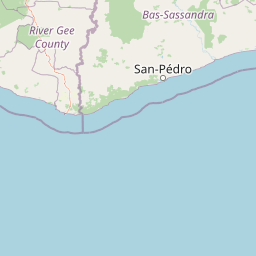
Map view of Sapo National Park

Use this park location map to pinpoint Sapo National Park in Liberia, understand its exact geographic position, and read its mapped placement within the surrounding landscape more clearly.

Pigeon | © OpenStreetMap contributors

Location context for Sapo National Park

Sinoe County
Park atlas

Compare Sapo National Park with adjacent protected areas, tracing the regional expanse of West Africa's Upper Guinean forest ecosystem.

Discover Nearby National Parks and Protected Areas Surrounding Sapo National Park, Liberia
Explore additional national parks and protected areas geographically near Sapo National Park, gaining context on West Africa's significant conservation landscapes. Broaden your understanding of regional biodiversity by comparing their mapped terrain, unique ecosystems, and conservation status within the Upper Guinean forest.
Protected areaNimba County

Gibi National Forest: Protected Tropical Forest in Nimba County, Liberia

Mapped landscape and regional geography of this key conservation area.

Gibi National Forest, a protected tropical forest spanning 607 square kilometers in Nimba County, Liberia, plays a crucial role in the preservation of the Upper Guinea forest ecosystem. Established in 1960, its landscape features tropical forest terrain near the mountainous Nimba Range. This protected area contributes significantly to regional conservation strategies, offering a vital habitat within a biodiversity hotspot that faces considerable pressure.

Area
607 km²
Established
1960
IUCN
VI
Climate
Tropical
National parkNimba County

Gio National Forest National Park: A Protected Landscape in Nimba County

Mapping the geographic boundaries and regional context of Gio National Forest.

Gio National Forest National Park serves as a key protected area within Liberia's Nimba County. This destination facilitates detailed exploration of its specific geographic footprint and its contribution to the regional atlas. Users can investigate the park's natural landscape context, mapped terrain, and its role as a protected conservation zone. Understand where this significant natural area fits within the broader geographic framework of West Africa.

Area
327 km²
Established
1960
IUCN
IV
Relief
Upland
National parkIvory Coast

Taï National Park: A Primary Rainforest Protected Area in Ivory Coast

Explore mapped boundaries and critical primate habitats in West Africa.

Taï National Park in Ivory Coast stands as a monumental protected landscape, comprising the largest contiguous area of primary rainforest remaining in West Africa. Its designation as a national park highlights its critical role in preserving biodiversity and unique geographic features. Users exploring this destination can delve into its mapped terrain, understand its regional landscape context within Ivory Coast, and appreciate its significance as a vital habitat for endangered species and an integral part of the Upper Guinean forest ecosystem.

Area
3,300 km²
Established
1972
IUCN
II
Relief
Upland
National parkIvory Coast

Mont Péko National Park: Ivory Coast National Park with Mapped Boundaries

Explore its protected landscape and regional geography.

Delve into Mont Péko National Park, a designated national park within Ivory Coast, to understand its unique protected landscape. This entry facilitates detailed atlas exploration, focusing on its geographic placement, mapped boundaries, and contribution to the regional natural terrain. Discover the essence of this protected area through its mapped geography and landscape identity.

Area
340 km²
Established
1968
IUCN
II
Relief
Mountain
Protected areaNimba County

Nimba National Forest: Protected Mountain Landscape & Bird Area in Nimba County

Explore mapped boundaries and regional geographic context.

Nimba National Forest, a protected area of approximately 187 square kilometers, is defined by its mountainous terrain in Nimba County, Liberia. Situated at the tri-border region with Guinea and Ivory Coast, this forest is recognized for its importance as a habitat for diverse bird species and its role in regional conservation efforts. Discover its mapped landscape, its position within the Nimba Range, and its ecological significance within West Africa's protected natural areas.

Area
187 km²
IUCN
VI
Access
Access unknown
Scope
Terrestrial
Protected areaGbarpolu County

Kpelle National Forest: Protected Area Identity and Geographic Exploration

Explore Gbarpolu County's protected landscape.

Kpelle National Forest is a key protected area offering a unique glimpse into Liberia's natural geography. This atlas-driven exploration focuses on understanding its specific boundaries, regional placement within Gbarpolu County, and the broader landscape context. Discover the protected area's identity and its significance for geographic comprehension, enabling detailed map-based exploration and regional comparison.

Area
1,748 km²
Established
1961
Relief
Mountain
Climate
Tropical
National parkSassandra-Marahoué District

Marahoué National Park: Protected Landscape and Geographic Setting in Ivory Coast

Mapped protected area boundaries and regional context.

Marahoué National Park represents a significant protected landscape within the Sassandra-Marahoué District, offering detailed geographic insights for atlas exploration. This entry focuses on the park's mapped boundaries and its identity as a national park, providing essential context for understanding its place in Ivory Coast's protected areas network. Discover the mapped terrain and regional landscape elements relevant to this protected natural site.

Area
1,000 km²
Established
1968
IUCN
II
Relief
Upland
National parkEastern Province

Gola Rainforest National Park: Sierra Leone's Premier Rainforest Protected Area

Explore mapped boundaries and biodiversity in Eastern Province's vast tropical rainforest.

Gola Rainforest National Park is Sierra Leone's second national park and the largest intact rainforest landscape in the country, located in the Eastern Province. As part of the Upper Guinea Forest biodiversity hotspot, it is renowned for its exceptional wildlife, including western chimpanzees and pygmy hippopotamuses. This protected area's mapped extent covers over 71,000 hectares, contributing significantly to regional conservation and providing a vital natural resource for both wildlife and local communities.

Area
710.7 km²
Established
2010
IUCN
II
Relief
Lowland

Common questions about visiting, size, designation, and location context for Sapo National Park

Sapo National Park FAQs for park facts, access, geography, and protected area context
Find quick answers about Sapo National Park, including protected-area facts, park geography, trail and visitor context, and how the park fits into its surrounding country and regional landscape.
MoriAtlas Explorer

Continue Your Protected Areas Search Across the Global Atlas

Deepen your exploration by continuing the structured search for national parks and protected areas worldwide. Utilize the comprehensive filtering capabilities to compare different conservation landscapes and refine your understanding of global park geography. Discover more about the distribution and characteristics of protected natural areas.

Global natural geography
