Mori Atlas logo
National parkGola Forest National Park

Mapping the primary rainforest boundaries and transboundary ecology of Western Liberia

Gola Forest National Park: A Crucial Protected Landscape in the Upper Guinea Rainforest Region

Gola Forest National Park represents one of the most significant protected tropical rainforest reserves in West Africa. Situated in Western Liberia, the park preserves a continuous, dense forest canopy that forms a core component of the Upper Guinea biodiversity hotspot. This mapped landscape supports a complex network of rivers and riparian habitats, serving as a vital anchor for transboundary conservation efforts that extend across the border into Sierra Leone.

tropical rainforestupper guinea forestsbiodiversity hotspottransboundary conservationprimary forestforest elephants

Gola Forest National Park

National park

Park overview

Structured park overview, official facts, and landscape profile for Gola Forest National Park

Gola Forest National Park park facts, protected area profile, and essential visitor context

Review the core facts for Gola Forest National Park, including designation, size, terrain, visitor scale, habitats, and operating context in one park-focused overview.

About Gola Forest National Park

Gola Forest National Park is a major rainforest protected area in the western part of Liberia, positioned along the country's frontier with Sierra Leone. It safeguards a substantial area of Upper Guinea forest and is widely regarded as one of the most ecologically significant reserves in West Africa. The park's identity is built around its conservation value: the large blocks of primary rainforest it preserves, the river systems that weave through them, and the biodiversity hotspot within which it sits.

Located in a region historically dominated by dense tropical forest, the park plays a disproportionate role in maintaining ecological connectivity across the Liberia-Sierra Leone border. This continuity with the nearby Gola Rainforest National Park in Sierra Leone is central to its broader significance, allowing forest-dwelling species to move across landscapes that are otherwise increasingly fragmented by agriculture, logging, and settlement.

From a governance perspective, Gola Forest National Park is managed under Liberia's Forestry Development Authority, with day-to-day conservation responsibilities resting with the Department of Forest Conservation. The reserve carries IUCN Category II status, reflecting its role as a national-level protected area with long-term conservation objectives. Its renaming to the current title in 2016 consolidated that role and signalled the park's relevance as a flagship Liberian protected area.

Internationally, Gola Forest is embedded in efforts to create a transboundary peace park across the Mano River region. The planned joint park would link the Liberian reserve with the Sierra Leonean park, creating one of West Africa's first large-scale cross-border forest conservation complexes. This places Gola Forest at the intersection of national biodiversity protection, regional ecological cooperation, and community-based conservation planning.

Quick facts and research context for Gola Forest National Park

Gola Forest National Park lies in western Liberia, near the Sierra Leone border, and was renamed to its current designation in 2016 after an earlier identity as Lofa-Mano National Park. It is classified as an IUCN Category II protected area and is managed under Liberia's Department of Forest Conservation within the Forestry Development Authority.

The park protects Upper Guinea rainforest, a globally significant ecological region, and functions as one of the last strongholds of primary West African tropical forest. Its conservation role extends across a network of streams, closed-canopy forest, and habitat used by forest elephants, primates, and antelope species.

Protection and recognition

Examine official designation records, terrestrial scope, and management frameworks.

Gola Forest National Park Protection Status and Transboundary History

Gola Forest National Park maintains documented terrestrial protection status established in 2016. Structured designation metrics provide verifiable baseline records for conservation geography researchers.

Protection details

Protection scope
Terrestrial
Designated year
2016
Transboundary protection
Yes
WDPA ID
9171
Park context

Deeper park guide and search-rich context for Gola Forest National Park

Gola Forest National Park history, landscape, wildlife, and travel context

Explore Gola Forest National Park through its history, landscape character, ecosystems, wildlife, conservation priorities, cultural context, and seasonal travel timing in a structured park guide built for atlas discovery and search intent.

Why Gola Forest National Park stands out

Gola Forest National Park is best known for preserving one of West Africa's most important remaining blocks of primary tropical rainforest and for sitting at the heart of the Upper Guinea forest biodiversity hotspot. Its ecological value lies in the combination of intact closed-canopy forest, river systems, and forest-dependent wildlife ranging from chimpanzees to pygmy hippos. The park is also recognized for its transboundary conservation significance. Together with Sierra Leone's neighbouring Gola Rainforest National Park, it forms the basis of a planned cross-border peace park, placing Gola Forest at the centre of one of West Africa's most ambitious landscape-level protection efforts.

Gola Forest National Park landscape and geographic character

The landscape of Gola Forest National Park is defined by the rolling, densely forested terrain typical of the Upper Guinea rainforest region. Closed-canopy tropical forest dominates the reserve, with primary rainforest stands forming a continuous blanket over the terrain. The undulating topography supports a mosaic of upland forest, hillside drainage, and valley-bottom vegetation, although the precise landforms remain understated in available sources.

Rivers and streams run through the forested interior, shaping the broader terrain and feeding the hydrology of the western Liberian landscape. These waterways create variations in moisture and soil conditions across the forest, breaking up the canopy and giving the ecosystem its internal structure. The result is a deeply forested, water-threaded environment rather than an open or dramatic landscape, and one in which ecological subtlety outweighs topographic spectacle.

Gola Forest National Park ecosystems, habitats, and plant life

Gola Forest National Park sits within the Guinean Forests region, one of the world's recognized biodiversity hotspots, and protects a habitat mosaic of primary rainforest, secondary growth, and riparian forest. The reserve functions as a refuge for forest types that have been heavily reduced elsewhere in West Africa, making it ecologically disproportionate to its size within the wider regional landscape.

The vegetation structure is dominated by tall tropical trees forming a closed canopy above a shaded understory. River-side zones along the park's drainage lines introduce semi-open gallery vegetation, while the surrounding upland forest maintains characteristic West African rainforest composition. This combination of mature forest and riparian edge habitat supports a wide spectrum of ecological niches, including feeding, breeding, and movement corridors for forest species.

Although the precise biodiversity inventories are not extensively documented in the source material, the park's ecological significance is clearly tied to its position within the broader Upper Guinea forest block. The reserve helps to maintain ecological functions such as watershed regulation, seed dispersal across an unbroken forest matrix, and the long-term viability of forest-dependent species that depend on large, connected areas of primary habitat.

Gola Forest National Park wildlife and species highlights

The wildlife of Gola Forest National Park reflects its identity as a primary rainforest reserve in the Upper Guinea hotspot. The park supports forest-dwelling primates, including chimpanzees, as well as other monkey species that rely on intact closed-canopy forest. Larger mammals in the reserve include pygmy hippopotamus and several antelope species adapted to dense forest, such as the sitatunga (called bongo in Italian sources), bushbuck, and zebra duiker.

Zebra duiker, classified as endangered in the source material, is one of the most notable conservation targets within the park, highlighting the reserve's role in protecting species under threat across West Africa. The forest elephant, a distinctive smaller elephant of Central and West African rainforests, historically occurred in the area, with cautionary population evidence suggesting very low historical numbers in the late twentieth century.

The park's rivers also support freshwater fauna. Various species of mormyrid fish inhabit the waterways, illustrating that the park's ecological importance extends from terrestrial forest into the aquatic habitats threaded through its landscape. Together, these species underline the reserve's value as a stronghold for forest, river, and riparian wildlife in a heavily transformed regional context.

Gola Forest National Park conservation status and protection priorities

Gola Forest National Park is a cornerstone of conservation in West Africa, protecting one of the largest remaining stands of primary Upper Guinea rainforest within Liberia. Its value comes from the combination of high biodiversity, intact forest cover, and the disruption to surrounding land uses, leaving the park as a refuge in an otherwise increasingly pressured region. The park's IUCN Category II status reflects its national importance for long-term ecosystem protection.

The reserve is part of the broader Guinean Forests biodiversity hotspot, a global conservation priority, and is considered key to the survival of species such as the endangered zebra duiker and the forest elephant. It also serves as a habitat anchor for forest-dependent primates, pygmy hippos, and freshwater fish communities.

A defining element of the park's conservation significance is its role as the Liberian partner in a planned transboundary peace park with Sierra Leone's Gola Rainforest National Park. The proposed joint reserve, supported through an international initiative, seeks to merge ecological management, anti-poaching work, and community engagement into a coherent cross-border conservation framework, elevating Gola Forest from a single national reserve into a regional conservation landscape.

Top sights and standout views in Gola Forest National Park

Gola Forest stands out for the scale and intactness of its primary rainforest within West Africa, a region where such forest has been heavily reduced. Its location directly opposite Sierra Leone's Gola Rainforest National Park gives it transboundary conservation significance that extends well beyond national borders.

The park is also notable for its role in safeguarding endangered and rare forest species, particularly the zebra duiker, and for the active planning of a cross-border peace park initiative with Sierra Leone. These qualities together place Gola Forest among the most strategically important forest reserves in the Upper Guinea region.

Monthly climate preview

Long-term temperature ranges and monthly precipitation cycles across the landscape

Gola Forest National Park Climate Normals and Annual Weather Patterns

Recorded baseline measurements indicate significant variation in monthly precipitation alongside steady annual temperature patterns across the representative coordinate. Analyzing the complete twelve-month climatology profile reveals detailed shifts in regional weather behavior and historical averages.
Annual mean25 °C
23 °C27 °C
Jan24°
Feb26°
Mar27°
Apr27°
May26°
Jun25°
Jul24°
Aug23°
Sep24°
Oct25°
Nov25°
Dec24°
Warmest month
March

26.9 °C

Coolest month
August

23.5 °C

Wettest month
August

15 mm/day

Driest month
January

0.3 mm/day

Park location guide

Geography guide, regional context, and park location map for Gola Forest National Park

Gola Forest National Park park geography, regions, and map view in Liberia

Understand where Gola Forest National Park sits in Liberia through a broader geographic reading of the surrounding landscape, nearby location context, and its mapped position within the national park landscape.

How Gola Forest National Park fits into Liberia

Liberia is a West African country on the Atlantic coast, bordered by Sierra Leone, Guinea, and Ivory Coast. Founded as an American Colonization Society settlement in 1822, it became Africa's first independent republic in 1847. The country has a population of approximately 5.4 million and uses both the US dollar and Liberian dollar as currency.

Wider geography shaping Gola Forest National Park in Liberia

Liberia occupies the West African Atlantic coast, stretching from Sierra Leone in the northwest to Ivory Coast in the east. The country features a coastal plain that rises to a rolling plateau and mountainous regions in the northeast. Several rivers, including the Mano and St. John rivers, flow across the territory. The climate is tropical with distinct wet and dry seasons.

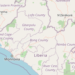
Map view of Gola Forest National Park

Use this park location map to pinpoint Gola Forest National Park in Liberia, understand its exact geographic position, and read its mapped placement within the surrounding landscape more clearly.

Pigeon | © OpenStreetMap contributors
Park atlas

Compare adjacent rainforest reserves, transboundary corridors, and forest ecosystems.

Explore Other Parks Near Gola Forest National Park and Regional Protected Areas

Continue browsing nearby national parks and protected areas surrounding Gola Forest National Park to evaluate regional conservation landscapes. Comparing these neighboring reserves reveals broader patterns across the Upper Guinea tropical rainforest ecosystem.
Protected areaGbarpolu County
About 34 km away#1 closest

South

Kpelle National Forest: Protected Area Identity and Geographic Exploration

Explore Gbarpolu County's protected landscape.

Kpelle National Forest is a key protected area offering a unique glimpse into Liberia's natural geography. This atlas-driven exploration focuses on understanding its specific boundaries, regional placement within Gbarpolu County, and the broader landscape context. Discover the protected area's identity and its significance for geographic comprehension, enabling detailed map-based exploration and regional comparison.

Area
1,748 km²
Established
1961
Relief
Mountain
Climate
Tropical
National parkLiberia
About 42 km away#2 closest

Southwest

Gola Forest National Park: Mapping the Protected Landscapes of Liberia

A critical forest sanctuary and regional geographic landmark in West Africa.

Gola Forest National Park functions as a key protected area within Liberia, defined by its expansive forest ecosystems. This resource illuminates the park geography and spatial distribution, providing a clear understanding of its role in regional conservation and West African environmental mapping.

National parkEastern Province
About 68 km away#3 closest

Southwest

Gola Rainforest National Park: Sierra Leone's Premier Rainforest Protected Area

Explore mapped boundaries and biodiversity in Eastern Province's vast tropical rainforest.

Gola Rainforest National Park is Sierra Leone's second national park and the largest intact rainforest landscape in the country, located in the Eastern Province. As part of the Upper Guinea Forest biodiversity hotspot, it is renowned for its exceptional wildlife, including western chimpanzees and pygmy hippopotamuses. This protected area's mapped extent covers over 71,000 hectares, contributing significantly to regional conservation and providing a vital natural resource for both wildlife and local communities.

Area
710.7 km²
Established
2010
IUCN
II
Relief
Lowland
Protected areaLiberia
About 104 km away#4 closest

Southwest

Gola National Forest Protected Area: Geographic Identity and Atlas Exploration

Liberia's protected landscape and mapped natural terrain.

Gola National Forest represents a vital protected area within Liberia, offering a distinct geographic identity for atlas-based exploration. This entry focuses on understanding its mapped boundaries and its significance as a protected landscape. Delve into the regional geography surrounding Gola National Forest to appreciate its natural context and its place within the broader conservation efforts of West Africa, presented with clear geographic and mapped data.

Area
2,069.9 km²
Established
1960
Climate
Tropical
Scope
Terrestrial
Biosphere reserveNzerekore Region
About 124 km away#5 closest

Northeast

Massif de Ziama Biosphere Reserve: Geographic Overview and Protected Forest Boundaries

A montane forest complex in the Nzerekore Region of Guinea.

Massif de Ziama functions as a significant forested mountain chain and protected biosphere reserve in the Nzerekore Region. This geographic profile details the massif's high-elevation terrain, its connectivity with the Kpo Range in Liberia, and its foundational importance as a remnant of the Upper Guinean forest formation.

Established
1980
Nature reserveGrand Cape Mount County
About 152 km away#6 closest

Southwest

Lake Piso Nature Reserve in Grand Cape Mount County: Protected Landscape Atlas

Coastal lagoon geography and wetland habitat mapping.

Lake Piso functions as a vital coastal nature reserve in Liberia, spanning roughly 103 square kilometers of brackish water, islands, and tidal forest. This protected area serves as an essential geographic anchor in Grand Cape Mount County, offering a complex terrain of mangrove ecosystems and river-fed channels that support significant biodiversity.

Area
103 km²
Established
1999
Relief
Lowland
Scope
Terrestrial
Nature reservePréfecture de Yomou
About 163 km away#7 closest

East

Réserve forestière de Diécké: Protected Forest Geography and Landscape Features

A critical lowland rainforest zone in Guinea

The Réserve forestière de Diécké protects 64,000 hectares of primary and secondary dense forest in southeastern Guinea. Its rugged, hilly terrain and river-carved lowlands support a closed-canopy ecosystem, providing a vital model for zoned forest conservation in the West African region.

Area
640 km²
Relief
Upland
Climate
Tropical
Scope
Terrestrial
Protected areaNimba County
About 208 km away#8 closest

East

Nimba National Forest: Protected Mountain Landscape & Bird Area in Nimba County

Explore mapped boundaries and regional geographic context.

Nimba National Forest, a protected area of approximately 187 square kilometers, is defined by its mountainous terrain in Nimba County, Liberia. Situated at the tri-border region with Guinea and Ivory Coast, this forest is recognized for its importance as a habitat for diverse bird species and its role in regional conservation efforts. Discover its mapped landscape, its position within the Nimba Range, and its ecological significance within West Africa's protected natural areas.

Area
187 km²
IUCN
VI
Access
Access unknown
Scope
Terrestrial

Common questions about visiting, size, designation, and location context for Gola Forest National Park

Gola Forest National Park FAQs for park facts, access, geography, and protected area context

Find quick answers about Gola Forest National Park, including protected-area facts, park geography, trail and visitor context, and how the park fits into its surrounding country and regional landscape.
MoriAtlas Explorer

Continue Your Protected Areas Search Across the Global Atlas

Deepen your exploration by continuing the structured search for national parks and protected areas worldwide. Utilize the comprehensive filtering capabilities to compare different conservation landscapes and refine your understanding of global park geography. Discover more about the distribution and characteristics of protected natural areas.

Global natural geography