Mori Atlas logo
Nature reserveLake Piso

Tracing the mapped boundaries, brackish water ecosystems, and tidal landscape of Liberia's largest freshwater lake.

Lake Piso Nature Reserve and Coastal Wetland Geography in Grand Cape Mount County, Liberia

Lake Piso serves as a central protected landscape in western Liberia, characterized by its oblong tidal lagoon and expansive mangrove-fringed wetlands. Located within Grand Cape Mount County, this nature reserve integrates diverse habitats including forested islands, tidal flats, and mixed-salinity channels. Recognized as both an Important Bird Area and a Ramsar site, the area provides a significant study of coastal geography and conservation in West Africa.

tidal lagooncoastal wetlandRamsar siteImportant Bird Areamangrove ecosystembrackish water

Lake Piso

Nature reserve

Park overview

Structured park overview, official facts, and landscape profile for Lake Piso

Lake Piso park facts, protected area profile, and essential visitor context

Review the core facts for Lake Piso, including designation, size, terrain, visitor scale, habitats, and operating context in one park-focused overview.

About Lake Piso

Lake Piso is Liberia's largest inland water body, a broad, oblong tidal lagoon that dominates the coastline of Grand Cape Mount County in the far west of the country. The lake sits immediately inland from the Cape Mount peninsula, with the small town of Robertsport on its shore and the Atlantic Ocean just beyond a narrow tidal inlet. Covering roughly 103 square kilometers, the lagoon combines freshwater inflow from several rivers with the saline influence of the sea, giving it a characteristically brackish character that defines both its ecology and its use.

Geologically and ecologically, the lake is a transitional coastal landscape where river systems, tidal channels, forested islands, and fringing wetlands converge. The Mole Creek and Mafa River are among the major freshwater inflows, while the bar mouth serves as the sole tidal outlet. The lake's mosaic of open water, mangrove margins, reedbeds, and small forested islands supports a rich community of waterbirds, primates, and other fauna. International recognition has followed this ecological richness: BirdLife International lists Lake Piso as an Important Bird Area, and the surrounding wetlands were formally designated as a Ramsar Wetland of International Importance in 2003, the only such designation in Liberia.

For the people of western Liberia, Lake Piso has long been both a working environment and a cultural anchor. The lake is the traditional homeland of the Vai people, who rely on its waters for fishing, transport, and trade. Before the disruption of the civil war era, the lagoon was also a popular destination for visitors drawn to its setting for activities such as swimming, canoeing, and water skiing. The surrounding catchments have additionally drawn interest for their diamond-bearing alluvial gravels, where igneous intrusions create conditions favorable to high-quality gem deposits.

Despite its protected status, the lake's history has also included difficult moments. Severe flooding in 1998, triggered in part by a blockage of the bar mouth and in part by seasonal rains, devastated communities in the Garwular District and led the Liberian government to declare the area a disaster zone. In 2002, the overcrowded ferry _Papa Friends 2000_ capsized at the confluence of the lake and Mafa River, with the loss of most of its passengers. These episodes underscore how closely the lives of local communities remain tied to the lake's physical condition.

Quick facts and research context for Lake Piso

Lake Piso is a tidal lagoon on the coast of western Liberia, in Grand Cape Mount County, lying adjacent to Robertsport. It is the largest lake in Liberia by surface area, covering approximately 103 square kilometers, and it connects to the Atlantic Ocean through a narrow tidal inlet informally called the bar mouth.

The lake has been recognized internationally for its ecological value. In 1999 a nature reserve was established in the surrounding area, and in 2003 the lake's wetlands were designated under the Ramsar Convention as a Wetland of International Importance, becoming Liberia's only site carrying that designation. BirdLife International has also identified the lake as an Important Bird Area due to its support for numerous bird species. The lake contains several islands, hosts communities of monkeys and waterbirds, and remains a center of traditional fishing and cultural life for the Vai people of the region.

Protection and recognition

Documented terrestrial designation history, management scope, and Ramsar listing

Lake Piso Protection Status and International Recognition Record

Lake Piso maintains documented terrestrial protection status established in 2003, supported by official international Ramsar recognition records. Conservation tracking brings together designation history and management scope details for structured atlas reference.

International recognition

Protection details

Protection scope
Terrestrial
Designated year
2003
Transboundary protection
No
Park context

Deeper park guide and search-rich context for Lake Piso

Lake Piso history, landscape, wildlife, and travel context

Explore Lake Piso through its history, landscape character, ecosystems, wildlife, conservation priorities, cultural context, and seasonal travel timing in a structured park guide built for atlas discovery and search intent.

Why Lake Piso stands out

Lake Piso is best known as Liberia's largest lake and as a coastal tidal lagoon of substantial ecological value. The lake is closely associated with internationally recognized biodiversity: its islands and fringing wetlands make it an Important Bird Area under BirdLife International, while the broader Lake Piso wetlands are Liberia's only Ramsar wetland of international importance, designated in 2003. The lake is also widely known as a cultural landmark of the Vai people, whose traditional homeland surrounds its shores.
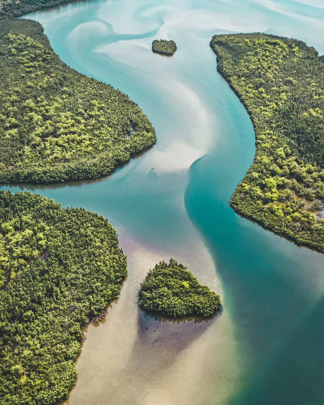
An aerial view looking down at a winding turquoise waterway surrounded by dense green forest, featuring small forested islands within the shallow sandy channels.
An aerial view of the tidal channels and lush vegetation at Lake Piso.

Lake Piso history and protected-area timeline

Lake Piso has played a varied role in the modern history of western Liberia. During the Second World War, the lagoon was used as a military base for Allied seaplanes, a function that drew on the lake's sheltered waters and direct connection to the sea. The lake later acted as a temporary refuge for Liberians displaced during the country's civil conflict.

The lake's environmental and human history include several difficult episodes. In 1998, the lake overflowed its banks at least twice. The first event was triggered by a blockage of the narrow inlet, or bar mouth, that connects Lake Piso to the Atlantic Ocean, and the second was driven by heavy seasonal rains. Combined, these floods affected more than twenty settlements, caused multiple deaths, and displaced thousands of people, leading the Liberian government to declare the area a disaster zone.

In December 2002, the wooden ferry _Papa Friends 2000_ capsized at the confluence of the lake and the Mafa River while carrying approximately 200 passengers returning from the funeral of a local footballer. Of those aboard, only about fifteen were rescued, and the remainder drowned or were presumed lost. The lake's conservation trajectory began to take shape in 1999, when a nature reserve was designated nearby. The wetlands, covering more than 76,000 hectares, were subsequently listed under the Ramsar Convention as a wetland of international importance in 2003, the first such designation in Liberia.

Lake Piso landscape and geographic character

The landscape of Lake Piso is one of broad, quiet water framed by the low ridges of the Cape Mount peninsula. The lake itself is long and oval, with a rough maximum extent of about 31 kilometers in length and 16 kilometers in width, lying nearly parallel to the Atlantic coastline. Its surface area of roughly 103 square kilometers makes it the dominant water feature of western Liberia.

Between the lake and the ocean lies a narrow strip of coastal land, shaped by the peninsula and broken by the single tidal inlet, or bar mouth, through which the lake exchanges water with the sea. The lake's shoreline blends into surrounding wetlands of mangroves, reedbeds, and seasonally inundated forest, while small islands rise from the water within the basin. Several rivers, among them the Mafa River and Mole Creek, flow into the lake, adding to the diversity of its margins and shaping its brackish, mixed-salinity character.

The result is a coastal wetland landscape that shifts between open water, river channels, tidal flats, mangrove stands, and low forested islands, forming a transitional environment between Liberia's interior forests and its Atlantic shoreline.

Lake Piso ecosystems, habitats, and plant life

Lake Piso represents one of the most ecologically important coastal wetland complexes in Liberia. Its combination of open brackish water, mangrove margins, reedbeds, river deltas, and forested islands creates a mosaic of habitats along the Atlantic coast.

The lake supports a wide range of birdlife and has been formally recognized as an Important Bird Area by BirdLife International because of the significant populations it sustains. Several small islands within the lake serve as refuges for primates, including monkeys, as well as for breeding and roosting birds. The fringing wetlands extend well beyond the lake's shoreline, and the larger Lake Piso wetland system covers tens of thousands of hectares of ecologically connected habitat.

The brackish character of the water, caused by the mixing of freshwater inflows from rivers like the Mafa and Mole Creek with tidal inflow from the Atlantic, shapes the lake's distinctive vegetation and fauna. Salt-tolerant mangrove communities line parts of the shore, while freshwater and tidal plant communities occupy the upper reaches of inflowing rivers.

Lake Piso wildlife and species highlights

Lake Piso's wildlife profile is anchored by its birdlife, which has brought the lake international recognition. Designated as an Important Bird Area by BirdLife International, the lake and its surrounding wetlands support populations of many bird species, drawing on its mix of open water, mangroves, reedbeds, and forested islands for feeding and breeding habitat.

The lake's islands provide an additional wildlife refuge. Monkeys are known to shelter on features such as Massatin Island within the lake, where vegetation cover and isolation from the mainland offer some protection. The surrounding wetlands extend habitat value beyond the lake itself, supporting migratory and resident waterbirds along the broader coastal wetland gradient.

The wildlife of the lake is bound up with local livelihoods: fish and other aquatic resources from Lake Piso support both subsistence and commercial fishing for the communities along its shores.

Lake Piso conservation status and protection priorities

Lake Piso holds a unique place in Liberia's conservation framework as the country's only Ramsar Wetland of International Importance, designated in 2003 under the international convention on wetlands.

The lake's protected status began to take formal shape in 1999, when a nature reserve was established nearby in recognition of the area's ecological value. BirdLife International has independently designated Lake Piso as an Important Bird Area, citing its role in supporting populations of numerous bird species. Together, these recognitions underline the lake's importance for regional biodiversity, particularly along Liberia's western coast, where natural wetland habitat has come under increasing pressure from human activity.

Conservation challenges in the area include the vulnerability of the lake's narrow tidal inlet, whose blockage in 1998 contributed to severe flooding, and the broader pressures on coastal wetlands from settlement, fishing, and resource extraction in the catchment. The lake's Ramsar designation reflects an intention to manage these competing pressures for long-term ecological integrity.

Lake Piso cultural meaning and human context

Lake Piso is central to the cultural identity of the Vai people, whose traditional homeland lies along the shores of the lagoon in Grand Cape Mount County. For generations, the lake has supported community life through fishing, transport, and trade, and the surrounding settlements have developed around its resources and rhythms.

The lagoon has also long served as a site of leisure and gathering. Before the disruption caused by the civil war years, Lake Piso was a popular destination for visitors from across Liberia and beyond, drawn to its setting for swimming, canoeing, and water-based recreation. Local events, including funerals and other communal gatherings, brought people together on the lake's waters, a pattern tragically highlighted by the 2002 _Papa Friends 2000_ ferry disaster. The lake's continued role in local cultural life remains intimately tied to its condition as a working waterway.

Top sights and standout views in Lake Piso

Lake Piso is distinguished by its scale, its ecological recognition, and its cultural depth. As the largest lake in Liberia and its only Ramsar Wetland of International Importance, it anchors conservation efforts across the country's western coast.

Its recognition as an Important Bird Area by BirdLife International, its mangrove- and island-rich brackish ecosystem, and its role as the cultural heartland of the Vai people together make it a natural landmark of national significance, while its layered modern history, from wartime seaplanes to wartime refuge and present-day fishing economy, gives it a distinctive place in Liberia's broader narrative.

Best time to visit Lake Piso

Lake Piso has a tropical coastal climate, with conditions shaped by proximity to the Atlantic Ocean and seasonal rainfall patterns typical of West Africa. The drier months tend to offer calmer conditions on the lagoon, clearer views of its islands and shoreline, and generally more comfortable conditions for activities such as canoeing, swimming, and other water-based recreation. Heavier rainfall periods can bring elevated water levels to the lagoon's rivers and wetlands, which may affect accessibility around the margins, while the lake's birdlife remains a year-round attraction.

Travelers should be aware that flooding events have historically been associated with periods of particularly heavy rainfall and disturbances to the bar mouth that regulates the lake's outflow into the Atlantic. Planning around the generally drier windows of the regional climate can help in experiencing the lagoon under more stable conditions.


Monthly climate preview

Track representative annual temperature ranges and monthly precipitation variations at Lake Piso

Lake Piso Climate Normals and Long-Term Weather by Month Preview

Lake Piso records persistent warmth throughout the year alongside distinct shifts in monthly precipitation rates derived from long-term coordinate data. Reviewing the complete twelve-month profile provides a structured breakdown of average temperatures and rainfall distribution across the protected area.
Annual mean27 °C
25 °C27 °C
Jan27°
Feb27°
Mar27°
Apr27°
May27°
Jun27°
Jul26°
Aug25°
Sep26°
Oct26°
Nov27°
Dec27°
Warmest month
April

27.4 °C

Coolest month
August

25.5 °C

Wettest month
August

11 mm/day

Driest month
January

0.4 mm/day

Park location guide

Geography guide, regional context, and park location map for Lake Piso

Lake Piso park geography, regions, and map view in Liberia

Understand where Lake Piso sits in Liberia through a broader geographic reading of the surrounding landscape, nearby location context, and its mapped position within the national park landscape.

How Lake Piso fits into Liberia

Liberia is a West African country on the Atlantic coast, bordered by Sierra Leone, Guinea, and Ivory Coast. Founded as an American Colonization Society settlement in 1822, it became Africa's first independent republic in 1847. The country has a population of approximately 5.4 million and uses both the US dollar and Liberian dollar as currency.

Wider geography shaping Lake Piso in Liberia

Liberia occupies the West African Atlantic coast, stretching from Sierra Leone in the northwest to Ivory Coast in the east. The country features a coastal plain that rises to a rolling plateau and mountainous regions in the northeast. Several rivers, including the Mano and St. John rivers, flow across the territory. The climate is tropical with distinct wet and dry seasons.

Map view of Lake Piso

Use this park location map to pinpoint Lake Piso in Liberia, understand its exact geographic position, and read its mapped placement within the surrounding landscape more clearly.

Pigeon | © OpenStreetMap contributors

Location context for Lake Piso

Grand Cape Mount County

Explore protected area views, mangrove habitats, and coastal wetland environments.

Lake Piso Photos and Landscape Scenery: Visualizing West Africa's Largest Tidal Lagoon

Examine detailed Lake Piso photos to understand the terrain, brackish waters, and forested islands defining this coastal wetland. Visual records reveal the landscape character, mangrove fringes, and natural habitats supporting regional biodiversity.

An aerial view looking down at a winding turquoise waterway surrounded by dense green forest, featuring small forested islands within the shallow sandy channels.

An aerial view captures a red dirt road running parallel to the sandy shoreline of a large, calm lake, with dense green forest on one side.

Park atlas

Compare regional wetland habitats and related protected natural areas in western Liberia

Explore Parks Near Lake Piso and Surrounding Protected Coastal Landscapes

Browsing national parks near Lake Piso reveals diverse coastal wetland ecosystems and protected natural reserves across the surrounding region. Expanding beyond individual lagoons provides valuable geographical context for regional conservation terrain.
Protected areaLiberia
About 58 km away#1 closest

East

Gola National Forest Protected Area: Geographic Identity and Atlas Exploration

Liberia's protected landscape and mapped natural terrain.

Gola National Forest represents a vital protected area within Liberia, offering a distinct geographic identity for atlas-based exploration. This entry focuses on understanding its mapped boundaries and its significance as a protected landscape. Delve into the regional geography surrounding Gola National Forest to appreciate its natural context and its place within the broader conservation efforts of West Africa, presented with clear geographic and mapped data.

Area
2,069.9 km²
Established
1960
Climate
Tropical
Scope
Terrestrial
National parkEastern Province
About 92 km away#2 closest

Northeast

Gola Rainforest National Park: Sierra Leone's Premier Rainforest Protected Area

Explore mapped boundaries and biodiversity in Eastern Province's vast tropical rainforest.

Gola Rainforest National Park is Sierra Leone's second national park and the largest intact rainforest landscape in the country, located in the Eastern Province. As part of the Upper Guinea Forest biodiversity hotspot, it is renowned for its exceptional wildlife, including western chimpanzees and pygmy hippopotamuses. This protected area's mapped extent covers over 71,000 hectares, contributing significantly to regional conservation and providing a vital natural resource for both wildlife and local communities.

Area
710.7 km²
Established
2010
IUCN
II
Relief
Lowland
National parkLiberia
About 109 km away#3 closest

Northeast

Gola Forest National Park: Mapping the Protected Landscapes of Liberia

A critical forest sanctuary and regional geographic landmark in West Africa.

Gola Forest National Park functions as a key protected area within Liberia, defined by its expansive forest ecosystems. This resource illuminates the park geography and spatial distribution, providing a clear understanding of its role in regional conservation and West African environmental mapping.

Protected areaGbarpolu County
About 139 km away#4 closest

Northeast

Kpelle National Forest: Protected Area Identity and Geographic Exploration

Explore Gbarpolu County's protected landscape.

Kpelle National Forest is a key protected area offering a unique glimpse into Liberia's natural geography. This atlas-driven exploration focuses on understanding its specific boundaries, regional placement within Gbarpolu County, and the broader landscape context. Discover the protected area's identity and its significance for geographic comprehension, enabling detailed map-based exploration and regional comparison.

Area
1,748 km²
Established
1961
Relief
Mountain
Climate
Tropical
National parkLiberia
About 152 km away#5 closest

Northeast

Gola Forest National Park: Geography and Protected Boundaries in Western Liberia

Primary tropical rainforest and Upper Guinea forest landscapes

Located in Western Liberia, Gola Forest National Park encompasses a major expanse of primary tropical rainforest. This protected area acts as a cornerstone of the Upper Guinea forest ecosystem, featuring undulating terrain, river-threaded drainage systems, and dense closed-canopy vegetation that remains essential for regional biodiversity and transboundary ecological connectivity.

Area
979.75 km²
Established
2003
IUCN
II
Relief
Mixed relief
Nature reservePréfecture de Yomou
About 263 km away#6 closest

East

Réserve forestière de Diécké: Protected Forest Geography and Landscape Features

A critical lowland rainforest zone in Guinea

The Réserve forestière de Diécké protects 64,000 hectares of primary and secondary dense forest in southeastern Guinea. Its rugged, hilly terrain and river-carved lowlands support a closed-canopy ecosystem, providing a vital model for zoned forest conservation in the West African region.

Area
640 km²
Relief
Upland
Climate
Tropical
Scope
Terrestrial
Watercolor painting of a green forested mountain landscape under a soft pastel sky.
Biosphere reserveNzerekore Region
About 270 km away#7 closest

Northeast

Massif de Ziama Biosphere Reserve: Geographic Overview and Protected Forest Boundaries

A montane forest complex in the Nzerekore Region of Guinea.

Massif de Ziama functions as a significant forested mountain chain and protected biosphere reserve in the Nzerekore Region. This geographic profile details the massif's high-elevation terrain, its connectivity with the Kpo Range in Liberia, and its foundational importance as a remnant of the Upper Guinean forest formation.

Established
1980
Protected areaNimba County
About 271 km away#8 closest

East

Gibi National Forest: Protected Tropical Forest in Nimba County, Liberia

Mapped landscape and regional geography of this key conservation area.

Gibi National Forest, a protected tropical forest spanning 607 square kilometers in Nimba County, Liberia, plays a crucial role in the preservation of the Upper Guinea forest ecosystem. Established in 1960, its landscape features tropical forest terrain near the mountainous Nimba Range. This protected area contributes significantly to regional conservation strategies, offering a vital habitat within a biodiversity hotspot that faces considerable pressure.

Area
607 km²
Established
1960
IUCN
VI
Climate
Tropical

Common questions about visiting, size, designation, and location context for Lake Piso

Lake Piso FAQs for park facts, access, geography, and protected area context

Find quick answers about Lake Piso, including protected-area facts, park geography, trail and visitor context, and how the park fits into its surrounding country and regional landscape.
MoriAtlas Explorer

Continue Your Protected Areas Search Across the Global Atlas

Deepen your exploration by continuing the structured search for national parks and protected areas worldwide. Utilize the comprehensive filtering capabilities to compare different conservation landscapes and refine your understanding of global park geography. Discover more about the distribution and characteristics of protected natural areas.

Global natural geography