
Mori Atlas logo
Wildlife reserveRéserve nationale de faune de la baie de l'Isle-Verte

Mapping the salt marshes and migratory waterfowl habitats of the Bas-Saint-Laurent coastal landscape

Réserve nationale de faune de la baie de l'Isle-Verte: A Critical Estuarine Wildlife Reserve

The Réserve nationale de faune de la baie de l'Isle-Verte protects one of the most significant cordgrass salt marshes remaining in southern Quebec. Located on the south shore of the St. Lawrence Estuary, this expansive wildlife reserve features a complex mosaic of tidal channels, mudflats, and shallow estuarine waters. As a primary staging ground and breeding site for diverse migratory waterfowl, the reserve stands as a crucial node in continental conservation geography within the Bas-Saint-Laurent region.

salt marshestuarine wetlandmigratory birdswaterfowl refugeRamsar siteImportant Bird Area
A stylized digital illustration of a mountain valley with a waterfall, pine trees, and a river flowing through the center.

Réserve nationale de faune de la baie de l'Isle-Verte

Wildlife reserve

Park overview

Structured park overview, official facts, and landscape profile for Isle-Verte Bay National Wildlife Area

Isle-Verte Bay National Wildlife Area park facts, protected area profile, and essential visitor context

Review the core facts for Isle-Verte Bay National Wildlife Area, including designation, size, terrain, visitor scale, habitats, and operating context in one park-focused overview.

About Isle-Verte Bay National Wildlife Area

Isle-Verte Bay National Wildlife Area is a small but ecologically dense protected coastal landscape in southeastern Quebec. It occupies the tidal fringe of the Baie de l'Isle-Verte, where the Rivière Verte meets the St. Lawrence Estuary, and consists largely of an expansive salt marsh dominated by cordgrass punctuated by numerous small, naturally formed pools. These shallow ponds, known locally as marelles, give the marsh its characteristic mosaic structure and provide sheltered feeding areas, nest sites, and rearing habitat for waterfowl.

The reserve is among the eight National Wildlife Areas in Quebec and forms the core of a broader conservation complex that also includes a Migratory Bird Sanctuary. Its significance lies in what remains: while many comparable estuarine marshes on the St. Lawrence have been lost or degraded over time, this one has retained a substantial portion of its natural tidal function, making it disproportionately important for migratory waterbirds that depend on predictable, high-quality stopover sites.

For visitors and conservationists alike, the area offers a chance to experience a working estuarine landscape where tidal rhythms, marsh vegetation, and bird life intersect. A network of short observation and interpretation trails links the marsh to the Maison Girard, a heritage building that serves as the visitor center for the site, and education and outreach are delivered in cooperation with the Kiskotuk Coastal Park organization.

Quick facts and research context for Isle-Verte Bay National Wildlife Area

Isle-Verte Bay National Wildlife Area is a Canadian National Wildlife Area established in 1980 and administered by the Canadian Wildlife Service. It lies within the Bas-Saint-Laurent administrative region of Quebec, in the municipality of L'Isle-Verte and neighboring Cacouna, roughly 30 kilometers east of Rivière-du-Loup.

The protected area encompasses a narrow coastal band of several kilometers along the bay, dominated by the largest remaining Spartina salt marsh in southern Quebec. The broader bay was designated a Ramsar site in 1987 and is recognized as an Important Bird Area. An adjoining Migratory Bird Sanctuary, created in 1986, adds an extra layer of protection for staging and feeding habitats used by geese, ducks, and shorebirds along the central St. Lawrence Estuary.

Protection and recognition

Explore documented conservation scope and historical designation records for the protected area.

Protection Status and Designation History for Réserve nationale de faune de la baie de l'Isle-Verte

Historical protected area designation data for Réserve nationale de faune de la baie de l'Isle-Verte spans mixed management frameworks established since 1987. Official conservation records outline baseline legal parameters and international database references for the protected landscape.

Protection details

Protection scope
Mixed
Designated year
1987
Transboundary protection
No
WDPA ID
555637726
Park context

Deeper park guide and search-rich context for Isle-Verte Bay National Wildlife Area

Isle-Verte Bay National Wildlife Area history, landscape, wildlife, and travel context

Explore Isle-Verte Bay National Wildlife Area through its history, landscape character, ecosystems, wildlife, conservation priorities, cultural context, and seasonal travel timing in a structured park guide built for atlas discovery and search intent.

Why Isle-Verte Bay National Wildlife Area stands out

The reserve is best known for protecting one of the last large, intact salt marshes of the middle St. Lawrence Estuary, an ecosystem that has otherwise been heavily diminished along this shoreline. Its Spartina marsh, dense with shallow ponds and tidal channels, creates exceptionally productive feeding and nesting habitat for waterfowl. It is also recognized as the foremost breeding area for the American Black Duck in Quebec and as a staging ground for enormous flocks of Snow Geese and Canada Geese. The combination of tidal marsh, mudflats, and estuarine open water makes it a stronghold for migratory bird conservation in eastern Canada.
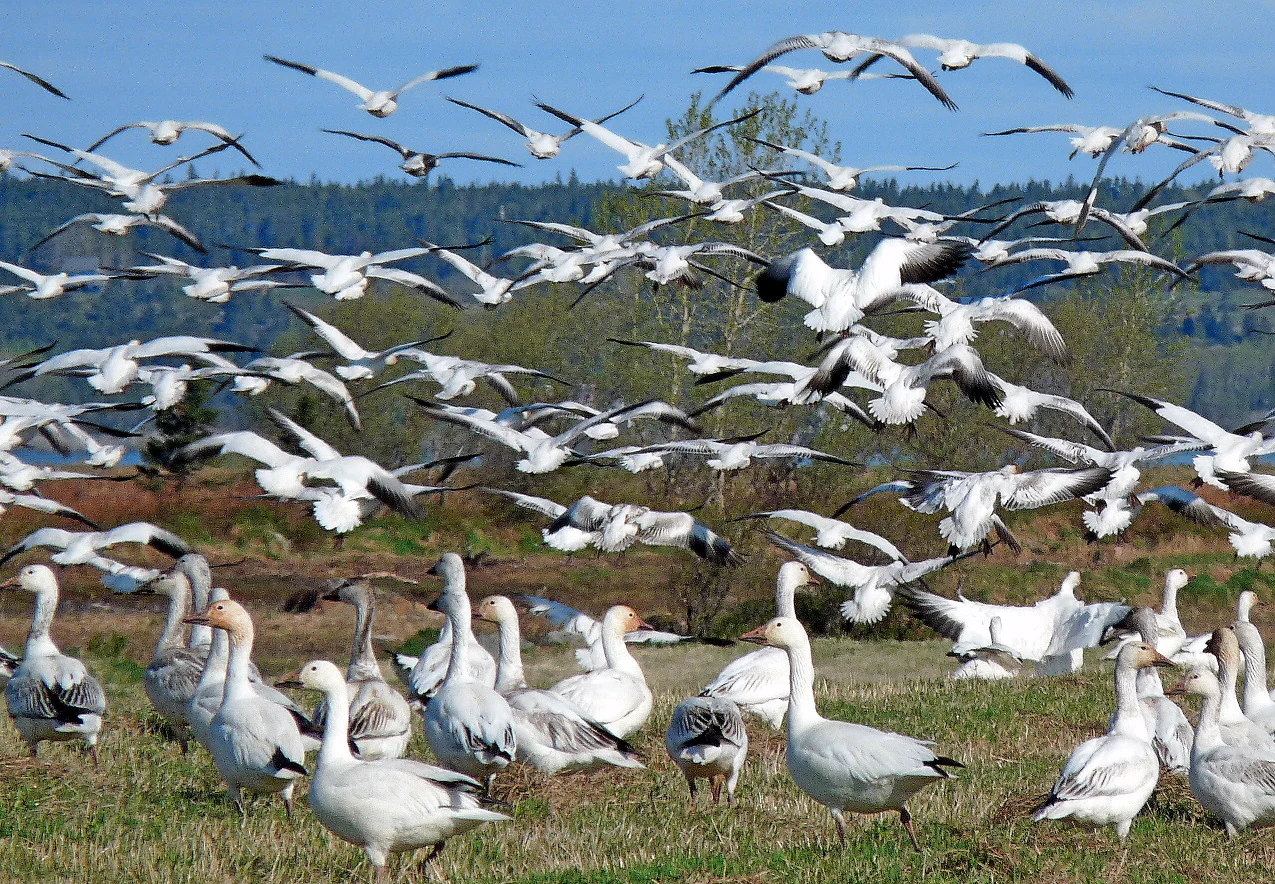
A large flock of white snow geese with black-tipped wings, some walking in a grassy field and many others flying in the air against a blue sky.
A large flock of snow geese at the Réserve nationale de faune de la baie de l'Isle-Verte.

Isle-Verte Bay National Wildlife Area history and protected-area timeline

Isle-Verte Bay National Wildlife Area was established in 1980 by the Canadian Wildlife Service with the explicit goal of protecting one of Quebec's largest and most ecologically valuable Spartina salt marshes. The marsh was recognized as essential breeding habitat for the American Black Duck, a species whose populations along the St. Lawrence had been declining due to habitat loss across the estuary.

In 1987, the broader Baie de l'Isle-Verte, encompassing the national wildlife area, was designated a Ramsar Wetland of International Importance, placing it within the global network of internationally significant wetlands. The adjacent Migratory Bird Sanctuary followed in 1986, reinforcing protections around the bay's migratory waterfowl concentrations.

Over time, management of interpretation and on-site visitor services has been carried out in cooperation with regional partners, including the PARC Bas-Saint-Laurent corporation within the broader Kiskotuk Coastal Park framework, integrating the reserve into a wider coastal conservation and public engagement landscape in the Bas-Saint-Laurent.

Isle-Verte Bay National Wildlife Area landscape and geographic character

The landscape of the reserve is shaped almost entirely by the interplay of tide, river, and salt-tolerant vegetation. A narrow coastal strip running along the bay for nearly twenty kilometers is dominated by an expansive Spartina marsh, the largest of its kind remaining in southern Quebec. The marsh is dissected by a network of tidal channels and dotted with shallow natural ponds, or marelles, that retain water at low tide and create a finely textured habitat mosaic.

Beyond the marsh itself, the broader setting includes intertidal mudflats, shallow estuarine waters of the St. Lawrence, and the freshwater influence of the Rivière Verte as it approaches the bay. Surrounding uplands are predominantly rural, with the village of L'Isle-Verte sitting to the west and Cacouna nearby, framing the protected area within a relatively intact agricultural and coastal landscape rather than a heavily developed shoreline.
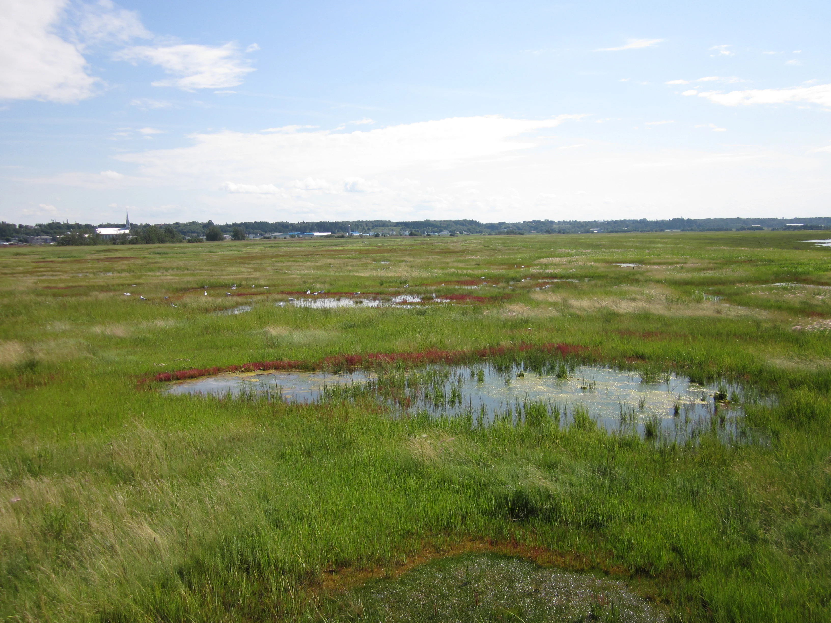
A wide, flat landscape of lush green salt marshes with small pools of water, under a light blue sky with wispy clouds, with a small town visible on the distant horizon.
Wide view of the expansive salt marshes at the Réserve nationale de faune de la baie de l'Isle-Verte.

Isle-Verte Bay National Wildlife Area ecosystems, habitats, and plant life

Ecologically, Isle-Verte Bay is defined by its tidal salt marsh, one of the defining estuarine habitats of the St. Lawrence. Spartina grasses form the structural backbone of the marsh, while the shallow tidal ponds and channels provide refuges where juvenile fish, invertebrates, and aquatic plants thrive. These conditions in turn sustain abundant insect, crustacean, and mollusk populations that fuel the food web for fish, shorebirds, and waterfowl.

The bay also functions as a transition zone between freshwater inputs from the Rivière Verte and the saline to brackish waters of the middle estuary, a gradient that increases biological productivity and habitat diversity. Surrounding shoreline vegetation includes typical northern estuarine marsh communities adapted to regular saltwater inundation, while the interplay of mudflats, marsh, and open water creates distinct microhabitats within a relatively compact area.

Isle-Verte Bay National Wildlife Area wildlife and species highlights

The reserve is fundamentally a bird area. Surveys have recorded more than 260 bird species using the broader bay, with around 130 species regularly frequenting the reserve itself and roughly 60 species nesting on site. Spring migration brings tens of thousands of birds through the area, while fall sees another substantial wave of staging waterfowl.

Dominant species include Snow Geese and Canada Geese, which use the marsh in large flocks, along with American Black Duck, Green-winged Teal, Northern Pintail, and Common Eider. Nesting species include Red-winged Blackbird, Song Sparrow, Common Yellowthroat, and Nelson's Sparrow, the latter being a species of particular conservation interest in northern marshes. Mammal life is typical of northern wetland edges and includes snowshoe hare, North American porcupine, red squirrel, groundhog, muskrat, red fox, and American mink, the last reflecting the wetland's role as predator habitat as well as prey base.

Isle-Verte Bay National Wildlife Area conservation status and protection priorities

The reserve's conservation significance rests on its role as one of the final intact examples of middle St. Lawrence estuarine salt marsh. Most comparable marshes upstream have been partially or entirely destroyed by shoreline alteration, making Isle-Verte Bay disproportionately important for species that rely on these specific tidal conditions.

Protection is layered: a National Wildlife Area status, Ramsar Wetland designation, and Important Bird Area recognition combine with an adjacent Migratory Bird Sanctuary to provide overlapping legal and international safeguards. Together, these designations protect critical breeding habitat for the American Black Duck, essential spring and fall staging areas for Snow Geese and Canada Geese, and one of the most important migratory waterfowl complexes on the south shore of the St. Lawrence. The site also functions as a reference ecosystem for understanding estuarine marsh function in this region, informing broader conservation work along the St. Lawrence.

Top sights and standout views in Isle-Verte Bay National Wildlife Area

One of the largest remaining Spartina salt marshes in southern Quebec, set within an internationally recognized Ramsar wetland on the middle St. Lawrence Estuary. The reserve is the foremost breeding ground for the American Black Duck in Quebec and a major staging area for Snow Geese, Canada Geese, and dozens of other waterbird species. A trail network and interpretation center at the Maison Girard connect visitors directly to this tidal marsh landscape, while the broader Important Bird Area and adjacent Migratory Bird Sanctuary extend protection across the surrounding bay.

Best time to visit Isle-Verte Bay National Wildlife Area

Spring and fall are the most ecologically dramatic periods at the reserve, corresponding to the major waterfowl migrations. In spring, tens of thousands of geese and ducks move through the bay, while fall brings large staging flocks and the open hunting season for migratory game birds in the surrounding area.

Summer offers the most active nesting period, when around sixty local bird species are breeding across the marsh and surrounding habitats; tidal conditions also make this a good time for observing marsh edge wildlife. Winter is quieter, with reduced access and a more muted bird presence, but the open tidal flats and frozen marsh continue to reflect the area's strong coastal character.

Monthly climate preview

Long-term temperature ranges and monthly precipitation averages across the protected area coordinate

Réserve nationale de faune de la baie de l'Isle-Verte Climate Normals and Annual Weather Patterns

Representative point measurements indicate significant temperature variations alongside steady precipitation distribution throughout the year at Réserve nationale de faune de la baie de l'Isle-Verte. Examining the comprehensive monthly climate profile reveals complete statistical breakdowns for long-term planning and comparative ecological research.
Annual mean3 °C
-13 °C17 °C
Jan-13°
Feb-12°
Mar-6°
Apr
May
Jun14°
Jul17°
Aug17°
Sep13°
Oct
Nov-1°
Dec-9°
Warmest month
July

17.4 °C

Coolest month
January

-13.2 °C

Wettest month
June

3.3 mm/day

Driest month
January

1.8 mm/day

Park location guide

Geography guide, regional context, and park location map for Isle-Verte Bay National Wildlife Area

Isle-Verte Bay National Wildlife Area park geography, regions, and map view in Canada

Understand where Isle-Verte Bay National Wildlife Area sits in Canada through a broader geographic reading of the surrounding landscape, nearby location context, and its mapped position within the national park landscape.

How Isle-Verte Bay National Wildlife Area fits into Canada

Canada is a federal parliamentary constitutional monarchy spanning North America from the Atlantic to the Pacific and Arctic Oceans. With a population of over 41 million, it is officially bilingual in English and French at the federal level. The country gained independence from the United Kingdom through a gradual process culminating in 1982.

Wider geography shaping Isle-Verte Bay National Wildlife Area in Canada

Canada occupies the northern portion of North America, sharing its longest international border with the United States. The country extends from the Atlantic Ocean to the Pacific Ocean and northward into the Arctic Ocean, giving it the longest coastline of any nation.

Map view of Isle-Verte Bay National Wildlife Area

Use this park location map to pinpoint Isle-Verte Bay National Wildlife Area in Canada, understand its exact geographic position, and read its mapped placement within the surrounding landscape more clearly.

Pigeon | © OpenStreetMap contributors

Location context for Isle-Verte Bay National Wildlife Area

Bas-Saint-Laurent

Visual reference guide to tidal marshes, estuarine waters, and protected habitats

Réserve nationale de faune de la baie de l'Isle-Verte Photos and Landscape Scenery

Visual records capture the expansive cordgrass marshes, tidal channels, and mudflats that define the estuarine environment of Réserve nationale de faune de la baie de l'Isle-Verte. Photographic documentation provides a detailed look at the terrain and waterfowl habitats supporting migratory bird populations along the St. Lawrence shoreline.

A large flock of white snow geese with black-tipped wings, some walking in a grassy field and many others flying in the air against a blue sky.

A wide, eye-level view of a green salt marsh under a clear blue sky, with tall grasses in the foreground and a distant tree line.

A wide, flat landscape of lush green salt marshes with small pools of water, under a light blue sky with wispy clouds, with a small town visible on the distant horizon.

Park atlas

Compare adjacent protected coastal wetlands and regional wildlife reserves

Parks near Réserve nationale de faune de la baie de l'Isle-Verte

Browse other protected areas near Réserve nationale de faune de la baie de l'Isle-Verte to compare surrounding estuarine wetlands and coastal habitats. Evaluating connected regional landscapes provides deeper context for bird conservation across the St. Lawrence estuary.
Wildlife reserveQuebec
About 1 km away#1 closest

West

Zugvogelschutzgebiet L’Isle-Verte Wildlife Reserve: Coastal Marsh and St. Lawrence Estuary Geography

Protected wetland boundaries and estuarine landscape in Quebec, Canada

Discover the geographic layout of Zugvogelschutzgebiet L’Isle-Verte, a specialized wildlife reserve in Quebec. This protected area centers on a productive tidal marsh system along the St. Lawrence Estuary, serving as an internationally recognized site for migratory waterfowl and shorebirds. The map-focused overview highlights the unique coastal terrain and the ecological significance of this narrow but vital strip of protected land.

Area
3.76 km²
Established
1986
IUCN
IV
Relief
Lowland
A watercolor painting showing a panoramic view of green islands surrounded by water against a pale, distant mountain range.
Wildlife reserveQuebec
About 27 km away#2 closest

West

Réserve nationale de faune des îles de l'Estuaire: Wildlife Reserve and Estuary Geography

Mapped protected island chain in the Quebec St. Lawrence Estuary.

This wildlife reserve encompasses a chain of small islands that provide predator-free nesting sites for seabirds and waterbirds. Situated along the St. Lawrence Estuary, the area acts as a critical link for regional conservation, supporting seals and marine life within a unique sedimentary landscape.

Area
4.04 km²
Established
1986
IUCN
Ia
Relief
Lowland
National parkQuebec
About 290 km away#3 closest

Southwest

La Mauricie National Park: Quebec National Park Atlas and Protected Landscape

Explore its mapped boundaries and natural terrain.

Delve into the protected landscape of La Mauricie National Park, a key national park situated within Quebec's diverse geography. This destination provides detailed insights into the park's mapped boundaries and its unique natural terrain, offering a structured approach to understanding protected areas and regional landscapes. It serves as an essential point for exploring the park's geographic identity and its place within the Canadian conservation atlas.

Area
536 km²
Established
1970
IUCN
II
Visitors
278.9K annual
Wildlife reserveNew Brunswick
About 327 km away#4 closest

Southeast

Portobello Creek National Wildlife Area: Protected Wetland Geography and Regional Atlas

Saint John River floodplain reserve in New Brunswick

Portobello Creek National Wildlife Area protects an expansive wetland complex characterized by riverine marshes, shrub thickets, and low-lying floodplain forests. As a key site within the Saint John River system, the reserve offers unique insight into the geomorphic and ecological character of Atlantic Canadian wetlands.

Area
21.54 km²
Established
1995
IUCN
Ia
Relief
Lowland
Wildlife reserveNew Brunswick
About 336 km away#5 closest

East

Île-du-Portage National Wildlife Area: Geographic Overview and Protected Island Mapping

A vital estuarine reserve on the New Brunswick coast

Study the coastal terrain of Île-du-Portage National Wildlife Area, an uninhabited island reserve situated at the junction of the Miramichi River and the Northumberland Strait. This overview focuses on the island's role as one of five National Wildlife Areas in New Brunswick, highlighting its significance within the broader estuarine geography and coastal maritime history of the Atlantic region.

Area
3.49 km²
Established
1979
IUCN
Ia
Relief
Lowland
National parkNew Brunswick
About 347 km away#6 closest

East

Kouchibouguac National Park: New Brunswick Protected Landscape Atlas

Mapped protected area boundaries and regional geography.

Kouchibouguac National Park is a designated national park offering a rich canvas for geographic discovery. This entry focuses on understanding its protected landscape, detailing its specific mapped boundaries within New Brunswick. It serves as a vital component for atlas exploration, providing the context needed to grasp the park's natural terrain and its significance within the regional geography.

Area
238 km²
Established
1969
IUCN
II
Visitors
243.5K annual
National parkQuebec
About 369 km away#7 closest

East

Forillon National Park: Quebec National Park Protected Landscape and Geography

Explore mapped park boundaries and regional terrain.

Forillon National Park represents a crucial component of Quebec's protected lands, offering a rich subject for geographic discovery and atlas exploration. This national park's specific landscape characteristics and mapped boundaries provide essential context for understanding its role within the wider regional geography of Canada. Dive into the mapped terrain and protected area details that make Forillon National Park a unique element in any natural landscape atlas.

Area
244 km²
Established
1970
IUCN
II
Visitors
164.1K annual
Wildlife reserveQuebec
About 382 km away#8 closest

Southwest

Réserve nationale de faune des îles de Contrecœur: Mapped Wildlife Reserve and Wetland Habitat

Protected freshwater ecosystems in the St. Lawrence River, Quebec

Discover the geographic footprint of the Réserve nationale de faune des îles de Contrecœur, a protected network of islands and channels in the St. Lawrence River. This entry provides context on the reserve's role in conserving emergent aquatic vegetation and waterfowl nesting sites within the broader southern Quebec landscape.

Area
3.12 km²
Established
1981
IUCN
Ia
Relief
Lowland

Common questions about visiting, size, designation, and location context for Isle-Verte Bay National Wildlife Area

Isle-Verte Bay National Wildlife Area FAQs for park facts, access, geography, and protected area context

Find quick answers about Isle-Verte Bay National Wildlife Area, including protected-area facts, park geography, trail and visitor context, and how the park fits into its surrounding country and regional landscape.
MoriAtlas Explorer

Continue Your Protected Areas Search Across the Global Atlas

Deepen your exploration by continuing the structured search for national parks and protected areas worldwide. Utilize the comprehensive filtering capabilities to compare different conservation landscapes and refine your understanding of global park geography. Discover more about the distribution and characteristics of protected natural areas.

Global natural geography