Mori Atlas logo
Nature reserveRéserve naturelle nationale de la Grotte du T.M. 71

Mapping the geological reach and subterranean integrity of a protected Pyrenean foothill cave system

Réserve naturelle nationale de la Grotte du T.M. 71: Protected Karst Landscape in Aude

The Réserve naturelle nationale de la Grotte du T.M. 71 preserves a significant underground karst network within the foothills of the Pyrenees in France. This protected area safeguards over eleven kilometres of mapped galleries, including delicate mineral formations and aragonite deposits that characterize this subterranean environment. Through strict conservation, the reserve acts as a critical reference for geological study and the long-term preservation of fragile limestone cave interiors.

cavekarstspeleologyunderground heritagelimestone landscapePyrenean foothills

Réserve naturelle nationale de la Grotte du T.M. 71

Nature reserve

Park overview

Structured park overview, official facts, and landscape profile for Grotte du T.M. 71 National Nature Reserve

Grotte du T.M. 71 National Nature Reserve park facts, protected area profile, and essential visitor context

Review the core facts for Grotte du T.M. 71 National Nature Reserve, including designation, size, terrain, visitor scale, habitats, and operating context in one park-focused overview.

About Grotte du T.M. 71 National Nature Reserve

The Grotte du T.M. 71 National Nature Reserve protects a deep limestone cave system in the uplands of the Aude, at the interface between the Pyrenean foothills and the broader landscape of Occitanie. While the surface area of the reserve is modest at around 96 hectares, the underground resource it shelters is the true subject of protection: a long decorated cave with a documented development of more than eleven kilometres and nearly 140 metres of vertical extent.

The site sits in the commune of Fontanès-de-Sault, a sparsely settled highland village not far from the axial Pyrenees. Above ground, the reserve covers the catchment and karst features that feed and shape the cave, while below ground the protected volume is what gives the area its conservation significance. The cave was first entered in 1971 by a caving group from Montpeyroux in the Hérault, who opened a small fissure to reveal a strong airflow and then pushed on to discover galleries and a large chamber.

From the earliest explorations, the explorers recognised both the aesthetic and mineral richness of the cave and chose to install a protective grille to prevent casual entry and damage. That grassroots decision laid the foundation for what would eventually become, sixteen years later, a formal national nature reserve under French law. Today the site is administered through the Association TM 71, reflecting the continuing role of the caving community in its stewardship.

Quick facts and research context for Grotte du T.M. 71 National Nature Reserve

The Grotte du T.M. 71 reserve is located near the village of Fontanès-de-Sault in the Aude department, in the southern French region of Occitanie. It was created by decree on 17 August 1987 and is administered by the Association TM 71. The reserve covers roughly 96 hectares and carries the IUCN category III designation as a natural monument or feature.

The protected area centres on a karst cave system whose known underground development exceeds 11,500 metres, with about 137 metres of vertical change. In the late 1990s and early 2000s the cave was part of a broader French candidacy proposing decorated caves of southern France for the World Heritage tentative list, though that wider proposal did not advance to inscription.

Protection and recognition

Documented protection records and global database identifiers

Réserve naturelle nationale de la Grotte du T.M. 71 Protection Status

Conservation metrics for Réserve naturelle nationale de la Grotte du T.M. 71 outline registered protection parameters and verified database identifiers. Official records compile administrative status details and international reference listings for protected area research.

Protection details

WDPA ID
39799
Park context

Deeper park guide and search-rich context for Grotte du T.M. 71 National Nature Reserve

Grotte du T.M. 71 National Nature Reserve history, landscape, wildlife, and travel context

Explore Grotte du T.M. 71 National Nature Reserve through its history, landscape character, ecosystems, wildlife, conservation priorities, cultural context, and seasonal travel timing in a structured park guide built for atlas discovery and search intent.

Why Grotte du T.M. 71 National Nature Reserve stands out

The reserve is best known for protecting one of the longest and most geologically significant decorated cave systems in the Aude, with kilometres of mapped galleries and notable mineral formations including aragonite. Its status as a near-total reserve, where public visitation is highly restricted in order to preserve fragile underground features, also makes it a reference site for cave conservation in France. The cave is a textbook example of Pyrenean foothill karst, featuring a deep network of passages cut into limestone and adorned with concretions that have been carefully preserved since its discovery. The site's role in the wider French debate on protecting decorated caves, and its inclusion in early World Heritage proposals, adds to its recognition beyond the local region.
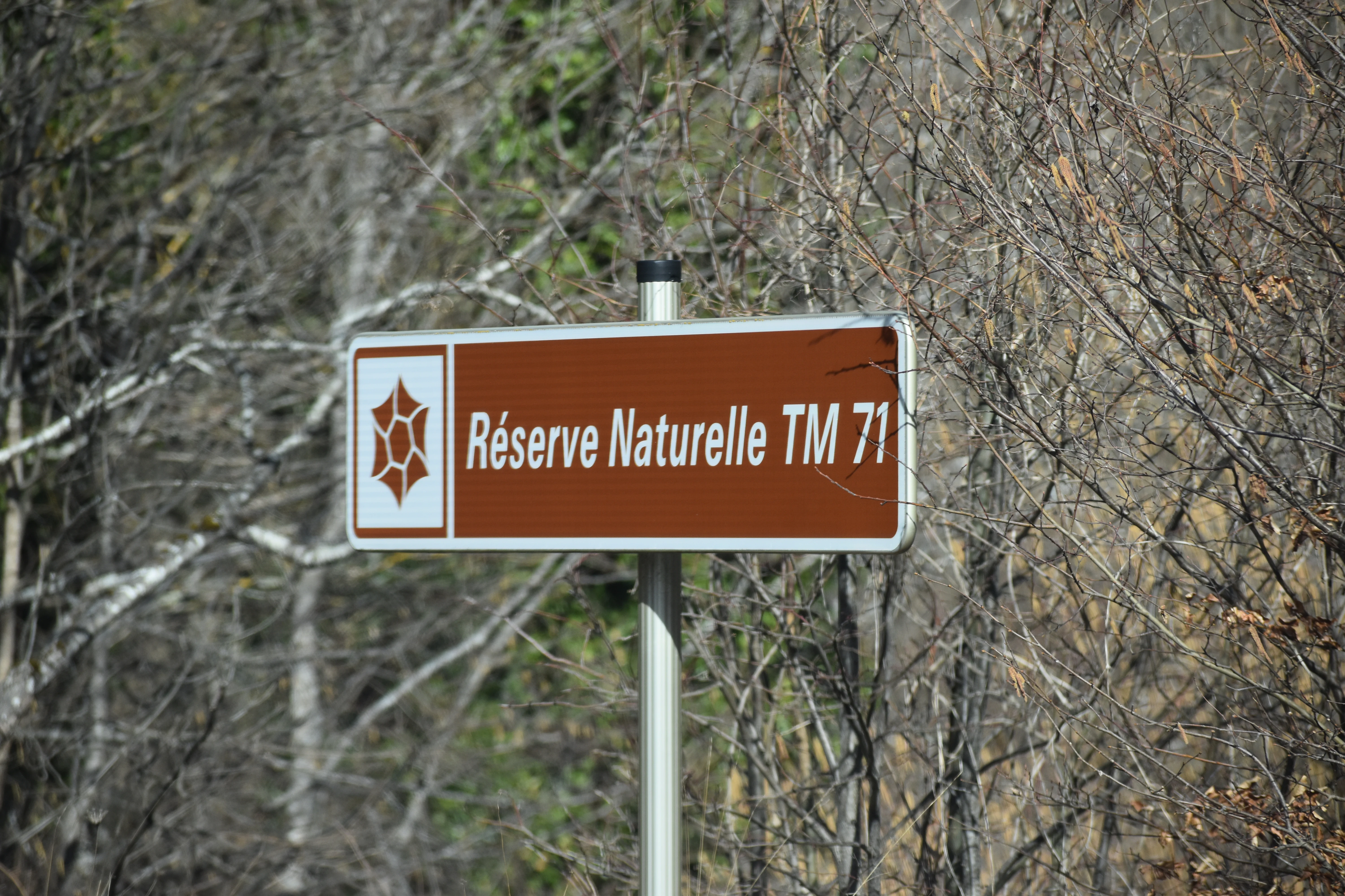
A brown rectangular informational sign for the Réserve Naturelle TM 71, featuring a white geometric emblem on the left, mounted on a metal pole against a background of bare trees.
Official signage identifying the Réserve naturelle nationale de la Grotte du T.M. 71 in France.

Grotte du T.M. 71 National Nature Reserve history and protected-area timeline

The history of the Grotte du T.M. 71 begins in 1971, when the Groupe spéléologique de Montpeyroux, based in the Hérault department, identified a fissure in the ground from which a strong draft of air emerged. After clearing the opening, the cavers pushed into the mountain and discovered a series of underground galleries and a sizeable chamber, revealing an extensive and richly decorated karst system beneath the Aude highlands.

Impressed by the fragility and beauty of what they had found, the young cavers decided almost immediately to install a protective grille across the entrance to safeguard the mineral formations inside. Throughout the 1970s, exploration continued and the cave was progressively mapped, eventually documenting more than eleven kilometres of passages and roughly 137 metres of vertical range, placing it among the most significant caves of the département.

Recognition of the site's conservation importance led to its formal classification as a national nature reserve by decree on 17 August 1987, under the French national nature reserves system. In the following decades the cave also became part of broader efforts to protect decorated caves in southern France: in 1999 a dossier proposing eighteen sites and twenty-four caves for inclusion on France's tentative World Heritage list was prepared, but in October 2001 the IUCN issued an unfavourable opinion, and the proposal was eventually withdrawn in 2007 in favour of a broader association of decorated caves. Throughout this period the local Association TM 71 has remained responsible for the day-to-day management and protection of the site.

Grotte du T.M. 71 National Nature Reserve landscape and geographic character

The reserve lies in the upland landscapes of the Aude, where the foothills of the Pyrenees begin to rise above the more open country of the southern Massif Central transition zone. The terrain above the cave is shaped by pasture, woodland, and the characteristic rocky outcrops of limestone country, with seasonal streams and sinkholes typical of mid-elevation karst regions. The surface topography reflects the same geological processes that carved the cave system below.

Beneath this landscape, the protected underground world is the true centrepiece. The cave unfolds as a long series of galleries cut by water through limestone, decorated with speleothems such as aragonite formations and other mineral concretions. The combination of substantial depth, considerable horizontal extent, and visually striking decoration gives the cave a strong scenic character despite being entirely hidden from the surface.

Grotte du T.M. 71 National Nature Reserve ecosystems, habitats, and plant life

The protected ecological value of the reserve is intrinsically linked to its underground character. The cave system supports a specialised biospeleological environment: the darkness, humidity, and stable temperatures of deep karst passages create habitats for cave-adapted invertebrates and microorganisms, and the reserve was established in part to preserve these fragile subterranean communities alongside the mineral heritage.

Above ground, the surrounding limestone hills carry the typical mosaic vegetation of upland Aude, with mixed woodland and open pasture in a mid-mountain climate. While the surface ecosystems are part of the protected perimeter, the cave itself is the dominant ecological and geological feature, with the surface area functioning largely as a protective buffer around the underground resource.

Grotte du T.M. 71 National Nature Reserve conservation status and protection priorities

The Grotte du T.M. 71 reserve lies within the French national nature reserves system, one of the strictest protection frameworks for natural heritage in the country. The site is classified under IUCN category III, recognising it as a natural monument or feature of outstanding value. Its primary conservation purpose is to safeguard both the mineralogical formations of the cave, including delicate aragonite deposits, and the specialised underground fauna that depends on the karst environment.

Because the reserve is managed as an almost integral reserve, visitation is deliberately kept extremely limited to avoid damage from humidity, breathing, lighting, or physical contact with formations. This strict approach reflects lessons drawn from decades of cave conservation in France, where even well-managed tourism has sometimes degraded fragile underground sites. The site's role in the broader French discussion of protecting decorated caves, and its early inclusion in World Heritage candidacy efforts, reinforces its conservation significance at a national level.

Top sights and standout views in Grotte du T.M. 71 National Nature Reserve

The Grotte du T.M. 71 stands out for the sheer scale of its known underground development, with more than eleven kilometres of mapped passages and significant vertical extent, placing it among the leading cavities of the Aude. Its aragonite formations and other delicate speleothems are protected within a near-total reserve framework that prioritises preservation over access. The site's grassroots origins, beginning with a grille installed by amateur cavers in the early 1970s and culminating in formal national protection in 1987, also give it a distinctive place in the history of French cave conservation.

Monthly climate preview

Long term representative point averages for monthly temperature and precipitation variation

Réserve naturelle nationale de la Grotte du T.M. 71 Climate Normals and Temperature Rhythms

Representative coordinate records show average monthly temperatures ranging from 3.39 °C to 21.08 °C alongside steady precipitation patterns throughout the year. Reviewing the complete twelve month climate profile reveals full monthly baseline statistics for regional temperature and precipitation ranges.
Annual mean11 °C
3 °C21 °C
Jan
Feb
Mar
Apr
May14°
Jun18°
Jul21°
Aug21°
Sep17°
Oct13°
Nov
Dec
Warmest month
August

21.1 °C

Coolest month
January

3.4 °C

Wettest month
November

2.8 mm/day

Driest month
July

1.4 mm/day

Park location guide

Geography guide, regional context, and park location map for Grotte du T.M. 71 National Nature Reserve

Grotte du T.M. 71 National Nature Reserve park geography, regions, and map view in France

Understand where Grotte du T.M. 71 National Nature Reserve sits in France through a broader geographic reading of the surrounding landscape, nearby location context, and its mapped position within the national park landscape.

How Grotte du T.M. 71 National Nature Reserve fits into France

France is a unitary semi-presidential republic and one of the world's largest economies. It borders Belgium, Luxembourg, Germany, Switzerland, Italy, Monaco, Andorra, and Spain, with a maritime border to the United Kingdom. The country is known for its cultural influence, art, cuisine, and political history spanning centuries.

Wider geography shaping Grotte du T.M. 71 National Nature Reserve in France

France is located in Western Europe. Metropolitan France extends from the Rhine to the Atlantic Ocean and from the Mediterranean Sea to the English Channel and North Sea. The country borders Belgium, Luxembourg, Germany, Switzerland, Italy, Monaco, Andorra, Spain, and has a maritime border with the United Kingdom.

Map view of Grotte du T.M. 71 National Nature Reserve

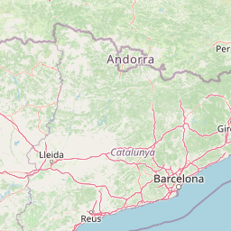
Use this park location map to pinpoint Grotte du T.M. 71 National Nature Reserve in France, understand its exact geographic position, and read its mapped placement within the surrounding landscape more clearly.

Pigeon | © OpenStreetMap contributors

Location context for Grotte du T.M. 71 National Nature Reserve

Occitanie

Visual exploration of Pyrenean foothill karst, limestone terrain, and subterranean habitats

Réserve naturelle nationale de la Grotte du T.M. 71 Photos and Landscape Scenery

Photographic documentation reveals the protected surface topography and underground karst features of Réserve naturelle nationale de la Grotte du T.M. 71. Visual records provide essential insight into limestone formations and restricted subterranean environments that remain closed to general public access.

A brown rectangular informational sign for the Réserve Naturelle TM 71, featuring a white geometric emblem on the left, mounted on a metal pole against a background of bare trees.

Close-up view of delicate, branch-like white aragonite crystal formations growing on a dark cave floor.

Park atlas

Compare surrounding protected landscapes and regional limestone terrain

Parks Near Réserve Naturelle Nationale de la Grotte du T.M. 71

Discover other protected areas and regional parks situated near Réserve naturelle nationale de la Grotte du T.M. 71. Comparing adjacent karst landscapes and Pyrenean foothill reserves provides broader context for subterranean conservation.
Nature reserveOccitanie
About 34 km away#1 closest

Southeast

Réserve naturelle régionale de Nyer: Mapped Geography and Protected Mountain Landscapes

Exploring the vertical terrain of a Pyrenean regional nature reserve

The Réserve naturelle régionale de Nyer offers a remarkable study in vertical zonation, featuring deep gorges and high alpine summits within the Pyrénées-Orientales. This protected area stands as a focal point for understanding the convergence of Mediterranean and mountain climates across the diverse topographical landscape of the Occitanie region.

Area
21.9 km²
Established
1998
Relief
Mountain
Climate
Mediterranean
Protected areaAndorra
About 45 km away#2 closest

Southwest

Madriu-Perafita-Claror Valley: Geographic Overview of Andorra's Premier Protected Landscape

An examination of glacial landforms and historic mountain heritage.

Spanning nine percent of Andorra, the Madriu-Perafita-Claror Valley remains a rare example of a preserved Pyrenean cultural landscape. This protected area features granite cliffs, glacial cirques, and historic ironworking remnants, offering a deep look into the environmental legacy of mountain societies within a remote, foot-access-only basin.

Area
42.47 km²
Established
2004
Relief
Mountain
Climate
Alpine
Watercolor painting of a river winding through a valley with green fields, trees, and distant hills
Protected areaAndorra
About 52 km away#3 closest

West

Parc Natural Comunal de les Valls del Comapedrosa: Andorra's Highest Protected Alpine Landscape

Explore the Pyrenean terrain and mapped boundaries of Andorra's summit park.

Parc Natural Comunal de les Valls del Comapedrosa is the primary high-altitude protected area in Andorra, defined by its rugged alpine terrain and the presence of Coma Pedrosa, the country's highest peak. This protected landscape offers a significant geographic anchor for exploring the Pyrenees, highlighting the unique mountain conservation efforts. Its mapped boundaries encompass dramatic valleys and steep ridges, providing a clear context for understanding Andorra's mountainous geography through a structured atlas lens.

Area
15.43 km²
Established
2003
IUCN
IV
Relief
Mountain
Watercolor painting of a tranquil natural landscape with a stream flowing through grassy hills, wildflowers, and a backdrop of distant purple-toned mountains.
Nature reserveOccitanie
About 83 km away#4 closest

East

Réserve naturelle nationale de la forêt de la Massane: Geographic and Protected Area Map

Ancient beech forest terrain in the Occitanie mountain landscape

Situated in the upper valley of the Massane river, this protected reserve provides a rare glimpse into ancient forest evolution. With its dense concentration of documented species and unique geological base, it stands as a reference point for studying climate change impacts on Mediterranean mountain terrain and protected woodland architecture.

Area
3.4 km²
Established
1973
IUCN
IV
Visitors
40K annual
Watercolor painting depicting a landscape with marshy green foreground, winding water, distant trees, and mountains under a light sky.
Nature reserveOccitanie
About 84 km away#5 closest

Northeast

Réserve naturelle régionale de Sainte-Lucie: Protected Coastal Geography in Occitanie

Coastal lagoons, island habitats, and Mediterranean marshlands.

This protected area profile explores the physical geography of Réserve naturelle régionale de Sainte-Lucie. Understand the interplay between the central island landform, brackish lagoon networks, and the Mediterranean beach ecosystems that define this unique French conservation landscape.

Area
8.25 km²
Established
2009
IUCN
IV
Relief
Lowland
Watercolor illustration of a mountainous landscape with a river, green vegetation, and distant peaks under a light sky
National parkProvince of Lleida
About 87 km away#6 closest

West

Aigüestortes i Estany de Sant Maurici National Park: Pyrenean High Mountain National Park Landscape

Explore glacial lakes and winding waterways in Catalonia.

Aigüestortes i Estany de Sant Maurici National Park is a premier national park in the Pyrenees, celebrated for its extensive network of almost 200 glacial lakes and the dramatic natural beauty of the Sant Maurici lake. Its landscape is defined by high mountain terrain, characterized by U-shaped valleys, sharp ridges, and unique hydrological features like the Aigüestortes plain's meandering streams. This protected area in the Province of Lleida offers a rich setting for understanding alpine environments and Pyrenean geography through detailed mapping and atlas exploration.

Area
141 km²
Established
1955
IUCN
II
Visitors
525K annual
Nature reserveOccitanie
About 91 km away#7 closest

North

Réserve naturelle régionale de Cambounet-sur-le-Sor: Protected Wetland Geography

Alluvial floodplain habitat in the Tarn, Occitanie

Situated in the Tarn department of Occitanie, this nature reserve guards a dense wetland habitat shaped by the confluence of the Sor and Agout rivers. The area stands as an ecological centerpiece, providing sheltered riparian woodland and marshy terrain for more than one hundred and seventy recorded bird species, making it a distinct study in French riverine conservation.

Area
0.309 km²
Established
1990
IUCN
IV
Relief
Lowland
A wide, soft-focus watercolor painting showing a winding river through a lush green valley with rolling hills in the background.
Nature reserveOccitanie
About 101 km away#8 closest

Northwest

Réserve naturelle régionale Confluence Garonne-Ariège: Protected Riverine Geography and Mapping

A significant riparian landscape in the Occitanie region

Discover the protected river corridors and diverse natural terrain of the Réserve naturelle régionale Confluence Garonne-Ariège. This regional nature reserve marks the confluence of the Garonne and Ariège rivers, showcasing a complex mosaic of alluvial forest, riparian wetlands, and dry hillside woodlands that characterize the geography south of Toulouse.

Area
5.791 km²
Established
2015
IUCN
IV
Relief
Mixed relief

Common questions about visiting, size, designation, and location context for Grotte du T.M. 71 National Nature Reserve

Grotte du T.M. 71 National Nature Reserve FAQs for park facts, access, geography, and protected area context

Find quick answers about Grotte du T.M. 71 National Nature Reserve, including protected-area facts, park geography, trail and visitor context, and how the park fits into its surrounding country and regional landscape.
MoriAtlas Explorer

Continue Your Protected Areas Search Across the Global Atlas

Deepen your exploration by continuing the structured search for national parks and protected areas worldwide. Utilize the comprehensive filtering capabilities to compare different conservation landscapes and refine your understanding of global park geography. Discover more about the distribution and characteristics of protected natural areas.

Global natural geography