Mori Atlas logo
Nature reserveRéserve naturelle nationale du Tanet-Gazon du Faing

Mapped terrain featuring subarctic heathlands, granite boulder fields, and diverse highland forest zones

Réserve naturelle nationale du Tanet-Gazon du Faing: A Protected Landscape in the Vosges Mountains

Located within the Grand Est region of France, Réserve naturelle nationale du Tanet-Gazon du Faing preserves a distinct mosaic of high-altitude ecosystems along the Vosges crest. The protected area encompasses rounded summits, including the Tanet and Gazon du Faing, which form a unique landscape of ericaceous heathlands, rare peat bogs, and granite tors shaped by glacial processes. This site offers an immersive look at subarctic-influenced montane geography through its expansive ridges and forest transitions.

national nature reserveVosges mountainshigh-altitude heathlandhautes chaumespeat bogericaceous shrubland

Réserve naturelle nationale du Tanet-Gazon du Faing

Nature reserve

Park overview

Structured park overview, official facts, and landscape profile for Tanet-Gazon du Faing National Nature Reserve

Tanet-Gazon du Faing National Nature Reserve park facts, protected area profile, and essential visitor context

Review the core facts for Tanet-Gazon du Faing National Nature Reserve, including designation, size, terrain, visitor scale, habitats, and operating context in one park-focused overview.

About Tanet-Gazon du Faing National Nature Reserve

The Tanet-Gazon du Faing National Nature Reserve lies at the heart of the Vosges mountains, occupying a high section of the massif's main crest that stretches between the Col du Bonhomme and the Col de la Schlucht. With elevations ranging from about 1,160 to 1,306 meters, the reserve captures the true upper zone of the Vosges, where harsh winters, acidic granitic soils, and centuries of grazing have shaped a distinctive suite of plant communities.

At its core, the reserve protects a mosaic of 'hautes chaumes', the traditional high pastures that have largely regained a wild character, alongside ericaceous heathlands dominated by heather, bilberry, cranberry, and bog whortleberry. Scattered across the slopes are roughly ten peat bogs of varying sizes, some still actively accumulating peat, others turning into bog woodland. Below the summits, the reserve also includes compact high-elevation beech forests and mixed beech-fir stands that were once the domain of the capercaillie and remain an important habitat for montane wildlife.

Geologically, the area is defined by the erosion of the underlying granite, producing spectacular boulder fields, tumbled blocks, and rounded granite domes that hint at the glacial history of the massif. The Roche des Fées, perched above the Route des Crêtes near the Gazon du Faing farm-inn at about 1,210 meters, is a particularly striking example of this landform vocabulary.

Created in 1988 and managed today by the Conservatoire d'espaces naturels de Lorraine, the reserve has both a conservation role and an interpretive role. A short educational trail of about 1.9 kilometers, starting from the farm-inn at the Gazon du Faing, introduces visitors to the site's flora, fauna, and geology, while a designated quiet zone protects sensitive species. With around 519 documented plant species and a rich community of montane and boreal birds and mammals, the reserve functions as a refuge for subarctic-flavored biodiversity within an otherwise densely populated European region.

Quick facts and research context for Tanet-Gazon du Faing National Nature Reserve

The Tanet-Gazon du Faing National Nature Reserve is a French national nature reserve (IUCN Category IV) covering about 505 hectares on the high crest of the Vosges mountains, in the Grand Est region and the Vosges department. It stretches between roughly 1,160 and 1,306 meters of altitude, crossing the communes of Le Valtin and Plainfaing on either side of the Route des Crêtes, close to the town of Gérardmer.

The reserve was established by decree on 28 January 1988 and is administered by the Conservatoire d'espaces naturels de Lorraine. It sits within the broader Parc naturel régional des Ballons des Vosges and its main landscapes include high-altitude heathlands, peat bogs, granite boulder fields, high-elevation beech forests, and mixed beech-fir forests. About 185 hectares receive reinforced protection and surveillance.

Protection and recognition

Documented protection metrics, administrative scope, and official recognition records

Réserve Naturelle Nationale du Tanet-Gazon du Faing Protection Status and Territorial Scope

Terrestrial protection boundaries and official WDPA records outline the administrative framework established for Réserve naturelle nationale du Tanet-Gazon du Faing. Documented conservation status details provide verifiable data regarding regional resource management and territorial oversight.

Protection details

Protection scope
Terrestrial
Transboundary protection
No
WDPA ID
39802
Park context

Deeper park guide and search-rich context for Tanet-Gazon du Faing National Nature Reserve

Tanet-Gazon du Faing National Nature Reserve history, landscape, wildlife, and travel context

Explore Tanet-Gazon du Faing National Nature Reserve through its history, landscape character, ecosystems, wildlife, conservation priorities, cultural context, and seasonal travel timing in a structured park guide built for atlas discovery and search intent.

Why Tanet-Gazon du Faing National Nature Reserve stands out

The reserve is best known for its high-altitude 'hautes chaumes' landscapes: treeless, ericaceous heathlands dominated by bilberry, cranberry, bog whortleberry, and heather, often described as subarctic in character. It is also recognized for its peat bogs, including raised and wooded mires harboring cottongrass, round-leaved sundew, bog rosemary, and Scheuchzeria palustris, and for its populations of boreal and montane bird species such as the ring ouzel, Eurasian woodcock, hazel grouse, and peregrine falcon. Its boulder-strewn granite slopes, including landmarks like the Roche des Fées above the Route des Crêtes, add a strikingly glacial geological character. Together these features make the reserve one of the most distinctive sites for upland, subarctic-influenced biodiversity in the Vosges massif.
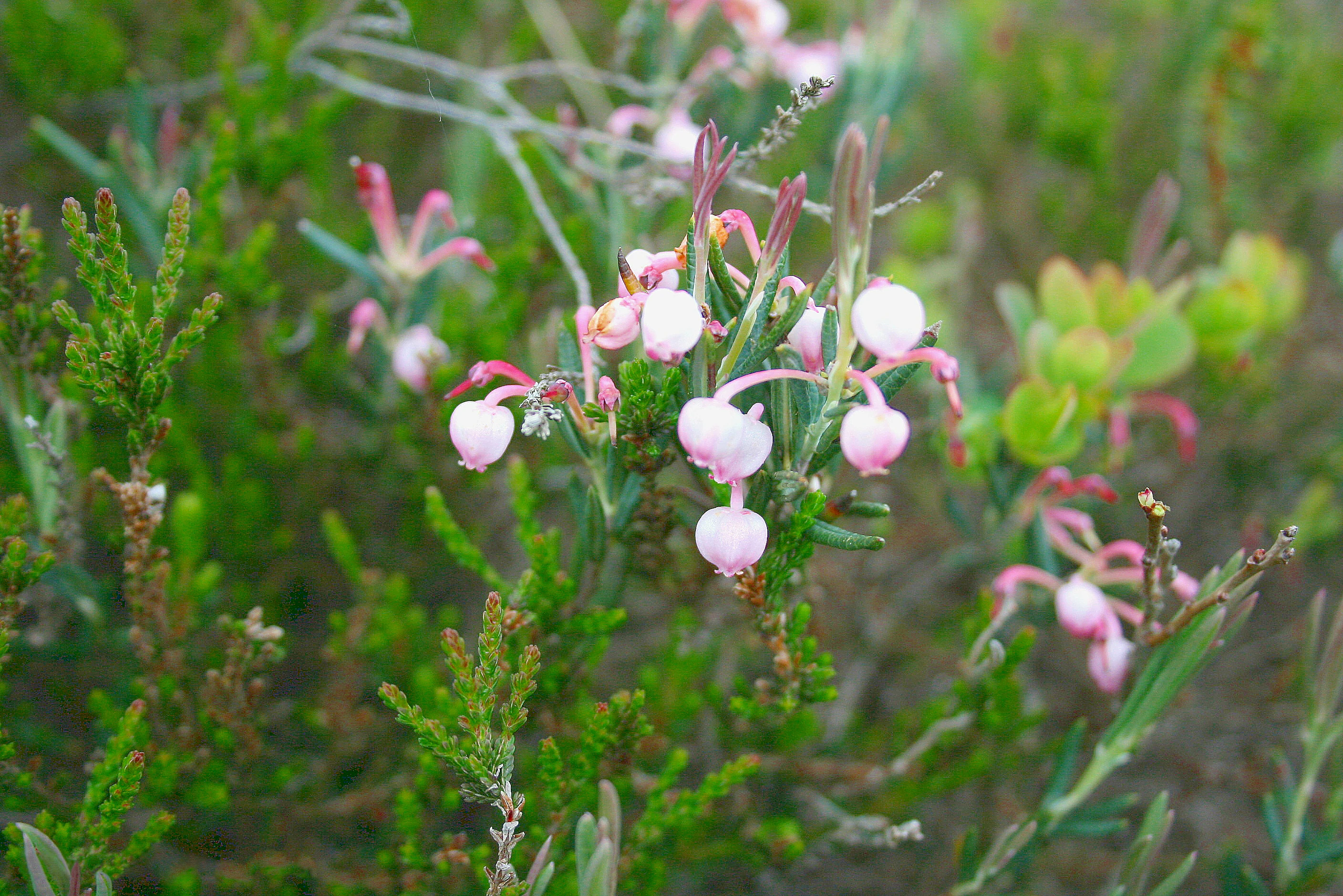
Close-up of pink and white bell-shaped Andromeda polifolia flowers growing among green heathland vegetation in a peatland
Andromeda polifolia blooming in the Tanet peatland

Tanet-Gazon du Faing National Nature Reserve history and protected-area timeline

The Tanet-Gazon du Faing reserve was established on 28 January 1988 through a French ministerial decree, formalizing protection of a landscape that had been shaped by centuries of high-altitude pastoral use. The site's older names reflect this grazing heritage: the Gazon du Faing, the Gazon du Faîte, and the Gazon du Tanet all refer to former summital grasslands where livestock once grazed on open, wind-swept pastures known locally as 'chaumes'.

As traditional mountain pastoralism declined across the Vosges, these summital landscapes were gradually abandoned. The vegetation rebounded into a mix of ericaceous dwarf shrubs, regenerating trees, and expanding peat bogs, transforming former pasture into semi-natural habitat. The 1988 decree recognized the ecological value of this abandoned cultural landscape and sought to protect both its biodiversity and its distinctive scenery.

The reserve was created across the communes of Le Valtin and Plainfaing, on either side of the Route des Crêtes, and was placed within the framework of the larger Parc naturel régional des Ballons des Vosges, which itself had been established to coordinate conservation and rural development across the southern Vosges. Since then, the Conservatoire d'espaces naturels de Lorraine has served as the site's managing body, implementing monitoring, habitat restoration, and visitor guidance while overseeing a stricter quiet zone for sensitive wildlife such as the capercaillie.

Tanet-Gazon du Faing National Nature Reserve landscape and geographic character

The reserve's landscape is dominated by high rounded summits and long, open ridges along the Vosges crest. The two highest points are the Tanet at 1,292 meters and the Gazon du Faing at 1,306 meters, forming a broad upland plateau where exposure to wind and cold has historically limited tree growth. The reserve sits on acidic, sandy soils derived from the weathering of the underlying granite, giving the terrain a pale, mineral character typical of the high Vosges.

Among the most visually striking features are the granite boulder fields, scattered blocks, and rounded granite tors that mark the long-term reshaping of the massif by glacial and periglacial processes. The Roche des Fées, overlooking the Route des Crêtes near the Gazon du Faing farm-inn at roughly 1,210 meters, is a particularly dramatic example of this landform vocabulary and has become a recognizable landmark within the reserve.

Below the exposed summits, slopes descend into denser vegetation zones. Compact high-elevation beech forests cling to some slopes, while mixed beech-fir forests occupy mid-elevations, transitioning gradually into more open sub-alpine communities above. Peat bogs, both open and partially wooded, punctuate the flatter ground, creating a mosaic of wet hollows, heath, and bog woodland that breaks up the otherwise continuous ridge topography.
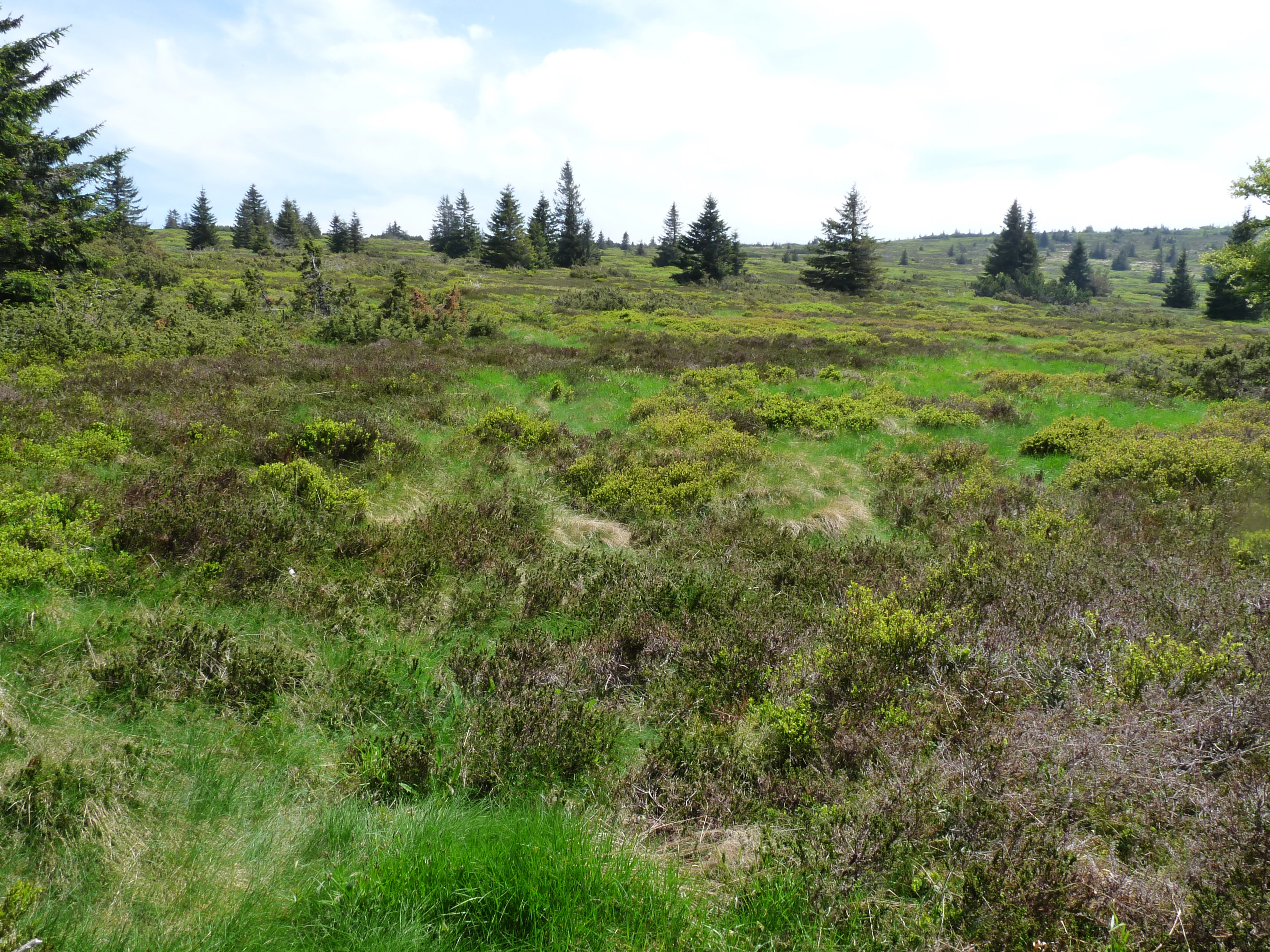
A landscape showing green and brown heathland vegetation with scattered coniferous trees in the background under a cloudy sky.
View of the heathlands and scattered conifers in the Tanet-Gazon du Faing National Nature Reserve.

Tanet-Gazon du Faing National Nature Reserve ecosystems, habitats, and plant life

Ecologically, the reserve belongs to the upper montane and sub-alpine zones of the Vosges, where acidic granite soils, high precipitation, and cold winters combine to support a flora with distinctly boreal and even subarctic affinities. About 519 plant species have been documented, including 237 vascular plants, 156 mosses, 102 lichens and fungi, and 24 ferns, an unusually high diversity for such a small, high-elevation area.

The open 'hautes chaumes' have largely been recolonized by ericaceous shrubs. Calluna heather dominates the most wind-exposed places, while bilberry thrives in areas with prolonged snow cover, and bog whortleberry, cowberry, and black crowberry extend the ericaceous layer into the bog margins. Remnant tufts of red fescue-like Nardus stricta recall the area's pastoral past. In damp hollows, mosses and Sphagnum allow peat to reaccumulate, with sedges, cottongrass, Scheuchzeria palustris, bog rosemary, round-leaved sundew, and Pinguicula butterwort forming a remarkable assemblage of bog specialists.

Altogether, these habitats create a layered ecological mosaic: open heath, active bog, bog woodland, and high-elevation forest, each supporting its own characteristic communities and providing the ecological foundation for the reserve's distinctive wildlife.

Tanet-Gazon du Faing National Nature Reserve wildlife and species highlights

Wildlife at Tanet-Gazon du Faing reflects the montane and boreal character of its habitats. The mix of open heath, peat bogs, rocky outcrops, and forest stands creates a rich variety of ecotones that supports a notable diversity of mammals, insects, and especially birds.

The reserve is particularly important for its birdlife, with species of mountain and northern affinity including the ring ouzel, Eurasian woodcock, hazel grouse, and peregrine falcon. These species depend on the combination of open ground, rocky cliffs, and quiet forest interiors offered by the reserve. A designated red zone, closed to visitors, protects especially sensitive habitat, including areas used by the capercaillie, the large grouse that has become an iconic symbol of the high Vosges and one of the main species conservation actions are aimed at supporting.

The diversity of habitats also supports a varied insect fauna and small mammal community, which in turn sustain the reserve's birdlife. Together, these faunal patterns reinforce the reserve's identity as one of the key upland refuges for boreal and subarctic wildlife in northeastern France.

Tanet-Gazon du Faing National Nature Reserve conservation status and protection priorities

The Tanet-Gazon du Faing reserve was created specifically to protect an exceptional concentration of high-altitude habitats in the Vosges, including heathlands, peat bogs, and high-elevation forests that had become rare in the region as traditional land use changed. Its IUCN Category IV status reflects its role as a habitat and species management area, where active conservation goes hand in hand with protection.

Conservation priorities center on maintaining and restoring the open character of the hautes chaumes, safeguarding the active peat-forming processes of the bogs, and protecting the forest mosaic that supports wildlife such as the capercaillie. About 185 hectares of the reserve benefit from reinforced protection and monitoring, and a designated quiet zone restricts human disturbance in the most sensitive areas.

By managing these landscapes in coordination with the surrounding Parc naturel régional des Ballons des Vosges and through the long-term oversight of the Conservatoire d'espaces naturels de Lorraine, the reserve functions as a core refuge within a broader conservation landscape, contributing to the survival of subarctic-influenced biodiversity in a heavily human-modified European context.

Tanet-Gazon du Faing National Nature Reserve cultural meaning and human context

The cultural context of the reserve is rooted in the long history of high-altitude pastoralism in the Vosges. The 'chaumes' of the Vosges crest have been used for summer grazing for centuries, and the very names Tanet, Gazon du Faing, and Gazon du Faîte evoke these open grazing lands. Local vocabulary such as 'brimbelier' for bilberry ties the landscape closely to regional rural traditions.

The reserve's creation in 1988 came at a moment when this pastoral heritage was fading, and protection effectively converted a former cultural landscape into a semi-natural one. Today, the site continues to be shaped by the legacy of grazing: the reappearance of ericaceous shrubs and the slow regrowth of forest are direct consequences of pasture abandonment. The nearby farm-inn at the Gazon du Faing, from which the educational trail begins, remains a tangible link to this older mountain economy.

Top sights and standout views in Tanet-Gazon du Faing National Nature Reserve

Key distinctions of the Tanet-Gazon du Faing reserve include its compact concentration of subarctic-style landscapes within the Vosges crest: high-altitude heathlands, active peat bogs, granite tors and boulder fields, and rare high-elevation beech and beech-fir forests. Among these, the peat bogs with cottongrass, round-leaved sundew, bog rosemary, and Scheuchzeria stand out for their botanical richness, while the heathland mosaic of heather, bilberry, and cranberry gives the site its most recognizable visual signature.

The reserve is also distinguished by its fauna, particularly its community of boreal and montane birds including ring ouzel, hazel grouse, Eurasian woodcock, and peregrine falcon, and by the quiet-zone protection it provides for the capercaillie. Combined with its manageable 1.9-kilometer educational trail and its location along the Route des Crêtes, the reserve offers a rare opportunity to encounter subarctic-flavored biodiversity in the heart of continental Europe.

Best time to visit Tanet-Gazon du Faing National Nature Reserve

Summer is by far the most rewarding season for visiting the reserve. The educational trail and the broader Route des Crêtes landscapes are most accessible when snow has retreated, typically from late spring through early autumn. During this period, the peat bogs are at their most visible and the heathland mosaic of heather, bilberry, and cranberry is in full color, while wildlife observation, especially birdwatching, is generally easier.

Spring can be a sensitive time for fauna, and the management plan discourages intensive visits during the breeding season; winter brings heavy snow that closes access and coincides with sensitive periods for wildlife. For most visitors, the warm and stable months offer the best balance between access, scenery, and ecological appreciation.

Monthly climate preview

Long term temperature ranges and monthly precipitation distributions recorded at representative park coordinates

Annual Climate Normals and Weather Patterns at Réserve naturelle nationale du Tanet-Gazon du Faing

Representative coordinates record sustained winter sub-zero minimums alongside warmer mid-year maximum temperatures and steady year-round precipitation. Examining twelve-month averages provides precise historical context regarding multi-year thermal rhythms across protected terrain.
Annual mean9 °C
0 °C18 °C
Jan
Feb
Mar
Apr
May13°
Jun16°
Jul18°
Aug18°
Sep14°
Oct
Nov
Dec
Warmest month
July

18.1 °C

Coolest month
January

-0.1 °C

Wettest month
May

3 mm/day

Driest month
April

2 mm/day

Park location guide

Geography guide, regional context, and park location map for Tanet-Gazon du Faing National Nature Reserve

Tanet-Gazon du Faing National Nature Reserve park geography, regions, and map view in France

Understand where Tanet-Gazon du Faing National Nature Reserve sits in France through a broader geographic reading of the surrounding landscape, nearby location context, and its mapped position within the national park landscape.

How Tanet-Gazon du Faing National Nature Reserve fits into France

France is a unitary semi-presidential republic and one of the world's largest economies. It borders Belgium, Luxembourg, Germany, Switzerland, Italy, Monaco, Andorra, and Spain, with a maritime border to the United Kingdom. The country is known for its cultural influence, art, cuisine, and political history spanning centuries.

Wider geography shaping Tanet-Gazon du Faing National Nature Reserve in France

France is located in Western Europe. Metropolitan France extends from the Rhine to the Atlantic Ocean and from the Mediterranean Sea to the English Channel and North Sea. The country borders Belgium, Luxembourg, Germany, Switzerland, Italy, Monaco, Andorra, Spain, and has a maritime border with the United Kingdom.

Map view of Tanet-Gazon du Faing National Nature Reserve

Use this park location map to pinpoint Tanet-Gazon du Faing National Nature Reserve in France, understand its exact geographic position, and read its mapped placement within the surrounding landscape more clearly.

Pigeon | © OpenStreetMap contributors

Location context for Tanet-Gazon du Faing National Nature Reserve

Grand Est

Visualizing high-altitude heathlands, granite boulder fields, and peat bogs across the Vosges crest

Réserve naturelle nationale du Tanet-Gazon du Faing Landscapes and Scenery Gallery

Photographic documentation reveals the distinctive subarctic character and glacial terrain defining Réserve naturelle nationale du Tanet-Gazon du Faing. Visual records provide essential context for understanding high-elevation flora, exposed ridges, and protected mountain habitats.

Close-up of pink and white bell-shaped Andromeda polifolia flowers growing among green heathland vegetation in a peatland

A wide field of white sheathed cottongrass plants covering a peat bog landscape, with a line of conifer trees in the background under a partly cloudy sky.

A landscape showing green and brown heathland vegetation with scattered coniferous trees in the background under a cloudy sky.

Park atlas

Compare nearby upland reserves and protected landscapes across the Vosges mountain crest

Parks Near Réserve Naturelle Nationale du Tanet-Gazon du Faing and Surrounding Protected Areas

Browsing other protected areas near Réserve naturelle nationale du Tanet-Gazon du Faing reveals connected high-altitude ecosystems and granite ridge topography. Examining adjacent upland reserves expands geographic comparison across the Grand Est regional conservation network.
A watercolor painting showing a wide panoramic view of green rolling hills and mountain ridges under a soft light.
Nature reserveGrand Est
About 14 km away#1 closest

Southwest

Réserve naturelle régionale des hautes-chaumes du Rothenbach: Protected Geography in the Vosges

A regional nature reserve in Grand Est, France.

This protected area provides a representative profile of the high Vosges mountains, spanning elevations from 900 to 1,300 metres. The terrain is characterized by an open mosaic of primary and secondary grasslands, known as chaumes, along with acidic heathlands and subalpine forests. Managed to preserve its fragile biodiversity, the site offers a deep look into the regional geography and the historical land use patterns that define the crests of Alsace.

Area
0.942 km²
Established
2008
IUCN
IV
Relief
Mountain
Nature reserveGrand Est
About 24 km away#2 closest

Southeast

Réserve naturelle régionale des collines de Rouffach: Protected Hills and Dry Grasslands

A Mediterranean-influenced nature reserve in the Alsace foothills.

Located in the Grand Est region, this reserve preserves Bollenberg and Strangenberg hills through a mosaic of downy oak woodland and xerobrometum grasslands. The site functions as a botanical refuge where limestone geology creates an exceptionally warm, arid environment rare for northeastern France.

Area
0.44 km²
Established
2013
IUCN
IV
A soft watercolor painting of a rolling landscape with green hills, light blue distant mountains, and patches of pink and yellow vegetation.
Nature reserveGrand Est
About 32 km away#3 closest

South

Réserve naturelle régionale de la forêt des volcans de Wegscheid: Geological Protected Area

Mapping volcanic terrain in the Grand Est region of eastern France.

Located in the Haut-Rhin, this regional nature reserve preserves a distinct volcanic landscape characterized by rocky promontories, basalt columns, and mature forest stands. The protected terrain features varied elevation from 700 meters to the Rossberg ridge, showcasing geological formations that have remained largely untouched by intensive historical forestry.

Area
1.015 km²
Established
2008
IUCN
IV
Relief
Mountain
A watercolor painting showing a soft, panoramic landscape of a peat bog or wetland with light green vegetation, scattered trees, and distant rolling hills on a white background.
Nature reserveGrand Est
About 32 km away#4 closest

Southwest

Réserve naturelle régionale de la tourbière des Charmes: Protected Mountain Peatland Geography

High Vosges mountain wetland and subalpine forest landscape

Located on the granite ridges of the Vosges mountains in the Grand Est region, this nature reserve preserves a vast, perched mountain peatland. Its distinct geographic character includes deep peat deposits and a habitat gradient transitioning from acidic wetland to mature fir and spruce forest, serving as a critical study area for specialized flora and cold-adapted wildlife.

Area
0.68 km²
Established
2008
IUCN
IV
Relief
Mountain
Nature reserveGrand Est
About 33 km away#5 closest

Southeast

Réserve naturelle régionale de l'Eiblen et l'Illfeld: Alsace Floodplain Protected Area

Geographic context of regional alluvial habitats in Haut-Rhin

Located in the Alsace plain, this nature reserve preserves a rare cross-section of original river floodplain geography. The area provides a critical look at alluvial ecosystems and sediment-rich lowland terrain that defines the historical character of the Upper Rhine plain within France.

Area
0.66 km²
Established
1992
A watercolor painting showing a wide view of a green field with clumps of trees in the foreground and soft rolling hills in the background under a pale sky.
Nature reserveBas-Rhin
About 33 km away#6 closest

Northeast

Réserve naturelle régionale du Ried de Sélestat, l'Ill*Wald: Protected Alluvial Forest Mapping

Explore the wetland geography and floodplain ecosystem of the Alsatian Grand Ried.

Spanning over 1,800 hectares, the Réserve naturelle régionale du Ried de Sélestat, l'Ill*Wald stands as one of the most significant regional nature reserves in France. This detailed atlas entry reveals its complex hydrological structure, consisting of dense forest, marshland, and a dense web of distributaries shaped by the Ill river and unique phreatic groundwater systems.

Area
18.55 km²
Established
1995
IUCN
IV
Relief
Lowland
Nature reserveGrand Est
About 38 km away#7 closest

Southeast

Réserve naturelle régionale de la forêt de Mequillet Le Hardtwald Geographic Atlas and Map

Protected dry forest and steppe habitat in Grand Est

Situated on the elevated terraces of the Rhine floodplain, this nature reserve protects 249 hectares of distinct dry woodland and open clearings. The landscape offers a rare example of continental flora and saproxylic beetle habitats, set within the broader agricultural context of the Alsace plain. This record provides a comprehensive view of the park boundaries and ecological geography found within this significant French conservation area.

Area
2.49 km²
Established
2012
IUCN
IV
Relief
Lowland
A panoramic watercolor painting depicting a calm wetland or marsh with pink and yellow reeds in the foreground, green trees in the midground, and soft purple mountains in the background.
Nature reserveHaut-Rhin
About 39 km away#8 closest

South

Réserve naturelle régionale des marais et landes du Rothmoos Protected Landscape and Geography

Regional nature reserve in the Haut-Rhin department of Alsace

The Réserve naturelle régionale des marais et landes du Rothmoos encompasses a rare inland saline habitat complex within the Nonnenbruch forest. Its terrain is defined by stable pools created from mining subsidence, transitioning into heathland and oak forests. This protected area stands as an ecological refuge for migratory waterbirds and specialized aquatic species within an industrial-legacy environment.

Area
1.457 km²
Established
1988
IUCN
IV
Relief
Lowland

Common questions about visiting, size, designation, and location context for Tanet-Gazon du Faing National Nature Reserve

Tanet-Gazon du Faing National Nature Reserve FAQs for park facts, access, geography, and protected area context

Find quick answers about Tanet-Gazon du Faing National Nature Reserve, including protected-area facts, park geography, trail and visitor context, and how the park fits into its surrounding country and regional landscape.
MoriAtlas Explorer

Continue Your Protected Areas Search Across the Global Atlas

Deepen your exploration by continuing the structured search for national parks and protected areas worldwide. Utilize the comprehensive filtering capabilities to compare different conservation landscapes and refine your understanding of global park geography. Discover more about the distribution and characteristics of protected natural areas.

Global natural geography