Mori Atlas logo
Nature reserveRéserve naturelle régionale Champagne de Méron

Analyzing the geographic boundaries and regional conservation significance of this French nature reserve.

Réserve naturelle régionale Champagne de Méron: A Protected Landscape in Pays de la Loire

Réserve naturelle régionale Champagne de Méron encompasses 146 hectares within the commune of Montreuil-Bellay in France. This site highlights the ongoing commitment of Pays de la Loire authorities to preserve semi-natural habitats within the rural Anjou countryside. Through its recent formal designation, the reserve acts as a vital component in the regional network of protected areas, maintaining ecological processes within a landscape historically defined by agricultural traditions.

regional nature reservewestern FrancePays de la LoireMaine-et-LoireMontreuil-BellayAnjou countryside

Réserve naturelle régionale Champagne de Méron

Nature reserve

Park overview

Structured park overview, official facts, and landscape profile for Réserve naturelle régionale Champagne de Méron

Réserve naturelle régionale Champagne de Méron park facts, protected area profile, and essential visitor context

Review the core facts for Réserve naturelle régionale Champagne de Méron, including designation, size, terrain, visitor scale, habitats, and operating context in one park-focused overview.

About Réserve naturelle régionale Champagne de Méron

The Réserve naturelle régionale Champagne de Méron represents a relatively recent expansion of protected natural heritage in the Pays de la Loire region. Established by a decision of the Regional Council on 14 April 2023, the reserve spans about 146 hectares of countryside in the commune of Montreuil-Bellay, within the Maine-et-Loire department.

The reserve falls within the cultural and natural landscape of Anjou, a region historically defined by the Loire valley, extensive agriculture, vineyards, and small river systems. While the protected area itself is modest in size, its designation reflects the broader French approach of strengthening ecological protection at the regional scale, complementing national parks, national nature reserves, and other protected-area categories.

As a régionales naturelle reserve, Champagne de Méron operates under the legal framework governing regional nature reserves in France. This framework allows regional authorities to establish protected areas that safeguard habitats, species, and ecological functions of regional importance. The reserve contributes to the patchwork of protected spaces in Maine-et-Loire, an area where agriculture and natural heritage have long intersected.

The site's inclusion in national and international databases, such as the Inventaire national du patrimoine naturel and the World Database on Protected Areas, underscores its formal recognition as part of France's protected-area estate. For visitors and researchers interested in regional conservation, the reserve offers an example of how relatively small parcels of land can be integrated into wider ecological networks in heavily cultivated landscapes.

Quick facts and research context for Réserve naturelle régionale Champagne de Méron

The Champagne de Méron reserve is classified as a regional nature reserve (réserve naturelle régionale) under French environmental law and carries the code RNR337. It was officially created on 14 April 2023 through a deliberation of the Regional Council of Pays de la Loire.

The protected area covers approximately 146 hectares and lies entirely within the commune of Montreuil-Bellay in the Maine-et-Loire department. It is registered in the World Database on Protected Areas under the identifier 555766614 and is listed in the French national inventory of protected natural spaces.

Protection and recognition

Documented terrestrial protection scope, management records, and verified designation entries

Protection Status and International Recognition for Réserve naturelle régionale Champagne de Méron

Terrestrial protection status, management scope, and official international designations provide verifiable context for Réserve naturelle régionale Champagne de Méron. Structured protected area records consolidate baseline conservation data and official designation histories without assumed outcomes.

Protection details

Protection scope
Terrestrial
WDPA ID
555766614
Park context

Deeper park guide and search-rich context for Réserve naturelle régionale Champagne de Méron

Réserve naturelle régionale Champagne de Méron history, landscape, wildlife, and travel context

Explore Réserve naturelle régionale Champagne de Méron through its history, landscape character, ecosystems, wildlife, conservation priorities, cultural context, and seasonal travel timing in a structured park guide built for atlas discovery and search intent.

Why Réserve naturelle régionale Champagne de Méron stands out

The reserve is primarily known as one of the newest additions to the network of regional nature reserves in Pays de la Loire, set within the agricultural and rural landscape of the Maine-et-Loire. Its designation highlights the region's commitment to preserving fragments of natural and semi-natural habitat within a historically farmed area. Although detailed ecological inventories are not yet publicly consolidated, the reserve's location places it within the broader context of Anjou's mixed farmland, hedgerow systems, and small woodland patches, habitats that are increasingly valued for their role in maintaining regional biodiversity.

Réserve naturelle régionale Champagne de Méron history and protected-area timeline

The reserve's history is brief and closely tied to the modern governance of natural areas in the Pays de la Loire region. It was formally created on 14 April 2023, following a deliberation by the Regional Council of Pays de la Loire, the public authority responsible for establishing régional nature reserves in France.

The designation places Champagne de Méron among the most recent additions to France's network of regional nature reserves, a category of protected area that has expanded steadily since the legal framework was strengthened in the early 2000s. The reserve's creation reflects the region's strategy of identifying and protecting ecologically valuable sites within a predominantly rural and agricultural setting.

Earlier history of the site itself is not detailed in available sources, though its location within the historic Anjou region suggests a long background of human land use, with the modern conservation designation representing a new chapter aimed at preserving the site's natural character.

Réserve naturelle régionale Champagne de Méron conservation status and protection priorities

The reserve's primary conservation significance lies in its role within the regional network of protected natural areas in Pays de la Loire. By formalizing protection over approximately 146 hectares of countryside in Montreuil-Bellay, the designation provides a legal framework for the long-term preservation of habitats and species in an area dominated by agricultural land use.

Its inclusion in national conservation inventories, including the Inventaire national du patrimoine naturel, ensures that the site is integrated into broader monitoring and reporting systems for French biodiversity. The reserve also contributes to the connectivity of natural spaces across the Maine-et-Loire department, complementing other protected and managed sites in the region.

As a recent designation, the reserve also represents an ongoing commitment by regional authorities to identify and protect ecologically meaningful places before further habitat loss or fragmentation occurs.

Réserve naturelle régionale Champagne de Méron cultural meaning and human context

The reserve lies within the Anjou region, an area with a rich cultural and historical identity shaped by the Loire Valley, traditional agriculture, viticulture, and rural communities. Montreuil-Bellay, the commune hosting the reserve, is itself known for its historic château and its position within the broader Anjou heritage landscape.

The designation of the reserve reflects a contemporary regional effort to balance the cultural and agricultural heritage of Anjou with the modern imperative of biodiversity conservation, recognizing that the two dimensions are closely intertwined in the French countryside.

Top sights and standout views in Réserve naturelle régionale Champagne de Méron

The reserve stands out as one of the most recently created regional nature reserves in France, designated in April 2023. Its compact size and location within the historic Anjou countryside make it a small but formally significant component of the Pays de la Loire's protected-area network.

For those interested in French regional conservation, the reserve provides a clear example of how ecological protection can be layered onto long-standing agricultural landscapes, and how regional authorities in France continue to expand their network of protected natural spaces at the local scale.

Best time to visit Réserve naturelle régionale Champagne de Méron

Available sources do not provide detailed seasonal information for visiting the Champagne de Méron reserve. As with most regional nature reserves in western France, late spring and early summer typically offer favorable conditions for observing flora and rural landscapes, with mild weather and active vegetation. However, any specific seasonal guidance should be confirmed through the managing authority or Réserves Naturelles de France.
Monthly climate preview

Long-term representative monthly averages for temperature and precipitation patterns

Annual Climate Normals and Temperature Rhythms for Réserve naturelle régionale Champagne de Méron

Historical data recorded between 1991 and 2000 reveals measured monthly temperature and precipitation fluctuations across the landscape. Examining the complete twelve-month climatology profile provides deeper insight into long-term environmental patterns.
Annual mean12 °C
4 °C20 °C
Jan
Feb
Mar
Apr10°
May14°
Jun18°
Jul20°
Aug20°
Sep17°
Oct12°
Nov
Dec
Warmest month
August

20 °C

Coolest month
January

4.3 °C

Wettest month
November

2.6 mm/day

Driest month
August

1.5 mm/day

Park location guide

Geography guide, regional context, and park location map for Réserve naturelle régionale Champagne de Méron

Réserve naturelle régionale Champagne de Méron park geography, regions, and map view in France

Understand where Réserve naturelle régionale Champagne de Méron sits in France through a broader geographic reading of the surrounding landscape, nearby location context, and its mapped position within the national park landscape.

How Réserve naturelle régionale Champagne de Méron fits into France

France is a unitary semi-presidential republic and one of the world's largest economies. It borders Belgium, Luxembourg, Germany, Switzerland, Italy, Monaco, Andorra, and Spain, with a maritime border to the United Kingdom. The country is known for its cultural influence, art, cuisine, and political history spanning centuries.

Wider geography shaping Réserve naturelle régionale Champagne de Méron in France

France is located in Western Europe. Metropolitan France extends from the Rhine to the Atlantic Ocean and from the Mediterranean Sea to the English Channel and North Sea. The country borders Belgium, Luxembourg, Germany, Switzerland, Italy, Monaco, Andorra, Spain, and has a maritime border with the United Kingdom.

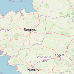
Map view of Réserve naturelle régionale Champagne de Méron

Use this park location map to pinpoint Réserve naturelle régionale Champagne de Méron in France, understand its exact geographic position, and read its mapped placement within the surrounding landscape more clearly.

Pigeon | © OpenStreetMap contributors

Location context for Réserve naturelle régionale Champagne de Méron

Pays de la Loire
Park atlas

Compare regional nature reserves and protected areas across the surrounding French countryside.

Explore Parks Near Réserve naturelle régionale Champagne de Méron and Surrounding Protected Landscapes

Continue geographic discovery by comparing protected areas adjacent to Réserve naturelle régionale Champagne de Méron across the wider Pays de la Loire region. Analyzing these connected natural spaces reveals how regional conservation networks safeguard rural habitats within agricultural terrain.
Nature reserveNouvelle-Aquitaine
About 16 km away#1 closest

Southwest

Réserve naturelle nationale du Toarcien: Protected Jurassic Stratotype and Geological Map

A vital paleontological heritage site in the Nouvelle-Aquitaine region

As the smallest national nature reserve in France, Réserve naturelle nationale du Toarcien provides a concentrated, scientifically essential view of Jurassic marine sediments. The protected quarries preserve ammonite-rich strata and complex geological unconformities, serving as the international definition for the Toarcian geological stage within the Thouet valley landscape.

Area
0.006 km²
Established
1987
IUCN
III
Relief
Lowland
Nature reserveNouvelle-Aquitaine
About 19 km away#2 closest

Southwest

Réserve naturelle régionale de la vallée du Pressoir: Protected Limestone Valley and Geoheritage

A rare natural and cultural mosaic in Nouvelle-Aquitaine

Trace the boundaries and natural features of the Réserve naturelle régionale de la vallée du Pressoir. This protected site in the Deux-Sèvres department is defined by thin calcareous soils, the historic Pommiers cascade, and fossil-rich limestone outcrops that form an unusual geoheritage landscape.

Area
0.56 km²
Established
2025
IUCN
IV
Visitors
10K annual
Nature reserveCentre-Val de Loire
About 23 km away#3 closest

East

Marais de Taligny Regional Nature Reserve: A Protected Wetland in Centre-Val de Loire

Alluvial valley geography and restored marshland habitats

Spanning the Négron valley, this regional nature reserve serves as an vital sanctuary for alkaline fen formations and diverse aquatic species. The site provides a detailed look at the intersection of riverine drainage, alluvial woodland, and the successful ecological restoration of historical French wetland landscapes.

Area
0.354 km²
Established
2014
IUCN
IV
Relief
Lowland
A soft watercolor illustration featuring a calm pond in the foreground, with reeds on the right and a distant treeline and rolling hills in the background.
Nature reservePays de la Loire
About 24 km away#4 closest

North

Réserve naturelle régionale des étang et boisements de Joreau: Protected Area Atlas Profile

Wetland and woodland mosaic in the Pays de la Loire region.

This profile examines the 92-hectare Réserve naturelle régionale des étang et boisements de Joreau, a protected area in the Maine-et-Loire department. The site features a specialized composition of freshwater ponds and mature woodlands, reflecting the traditional riverine landscapes found throughout the broader Loire Valley regional geography.

Area
0.92 km²
Established
2015
IUCN
IV
Nature reservePays de la Loire
About 51 km away#5 closest

Northwest

Réserve naturelle régionale de Basses-Brosses et Chevalleries: Protected Area Mapping

A dense bocage landscape in the Pays de la Loire region

This regional nature reserve protects a well-preserved mosaic of meadows, cultivated plots, and wooded hedgerows across 90 hectares. The site serves as a vital ecological anchor in the Maine-et-Loire department, maintaining traditional land patterns and diverse species habitats that define the historic rural character of the Anjou countryside.

Area
0.9 km²
Established
2012
IUCN
IV
A soft watercolor painting of a serene natural landscape with rolling hills, a calm body of water, and forested ridges under a pastel sky.
Nature reserveFrance
About 62 km away#6 closest

Southeast

Réserve naturelle régionale du site de Saint-Cyr: Wetland Geography and Protected Landscapes

Mapping a 39-hectare wetland refuge along the Clain river in France.

Located in the Vienne department, this regional nature reserve provides a critical link for waterbirds moving between the Loire valley and the Atlantic coast. The landscape features a mosaic of ponds, small islands, and alluvial forests that highlight the successful transition from former industrial quarry land into a biodiverse wetland ecosystem.

Nature reservePays de la Loire
About 63 km away#7 closest

North

Réserve naturelle régionale des marais de Cré-sur-Loir et La Flèche Protected Landscape

Wetland ecosystems in the Pays de la Loire region.

Spanning an old meander of the Loir river, this regional nature reserve preserves a complex network of marshes, canals, and alluvial forests. Learn about its unique floodplain geography and the protected wetland habitats that sustain regional biodiversity in the heart of the Sarthe department.

Area
0.531 km²
Established
2008
IUCN
IV
Relief
Lowland
Nature reservePays de la Loire
About 67 km away#8 closest

North

Réserve naturelle régionale du coteau et prairies des Caforts: Protected Area and Map Atlas

A diverse protected landscape in the Pays de la Loire region

Situated in the Loir valley, this regional nature reserve combines three distinct landscape types: dry limestone slopes, humid hay meadows, and 910 meters of man-made tuffeau quarry galleries. The site represents a significant pocket of biodiversity, hosting sixteen bat species and rare flora within its compact protected footprint in Sarthe.

Area
0.064 km²
Established
2009
IUCN
IV

Common questions about visiting, size, designation, and location context for Réserve naturelle régionale Champagne de Méron

Réserve naturelle régionale Champagne de Méron FAQs for park facts, access, geography, and protected area context

Find quick answers about Réserve naturelle régionale Champagne de Méron, including protected-area facts, park geography, trail and visitor context, and how the park fits into its surrounding country and regional landscape.
MoriAtlas Explorer

Continue Your Protected Areas Search Across the Global Atlas

Deepen your exploration by continuing the structured search for national parks and protected areas worldwide. Utilize the comprehensive filtering capabilities to compare different conservation landscapes and refine your understanding of global park geography. Discover more about the distribution and characteristics of protected natural areas.

Global natural geography