
Mori Atlas logo
Nature reserveRéserve naturelle régionale de l'Escaut-rivière

Examining the ecological corridor and regenerating forest ecosystems of the upper Escaut river valley

Réserve naturelle régionale de l'Escaut-rivière: Mapped Protected Alluvial Landscapes

The Réserve naturelle régionale de l'Escaut-rivière represents the final natural segment of the upper Escaut river before its path becomes canalized toward the North Sea. Located within the Cambrésis plain of Hauts-de-France, this protected area features a rare mosaic of wet meadows, reedbeds, and spontaneously regenerating alluvial forests. It serves as a vital biological reservoir and fluvial corridor, preserving remnant wetland habitats in a region defined by intensive agricultural land use.

alluvial forestwet meadowsfloodplainriver corridorwetlandsrenaturation
A stylized vector illustration featuring a winding river in the foreground, coniferous trees on both sides, and a tiered waterfall cascading down steep mountain cliffs in the background.

Réserve naturelle régionale de l'Escaut-rivière

Nature reserve

Park overview

Structured park overview, official facts, and landscape profile for Réserve naturelle régionale de l'Escaut-rivière

Réserve naturelle régionale de l'Escaut-rivière park facts, protected area profile, and essential visitor context

Review the core facts for Réserve naturelle régionale de l'Escaut-rivière, including designation, size, terrain, visitor scale, habitats, and operating context in one park-focused overview.

About Réserve naturelle régionale de l'Escaut-rivière

The Réserve naturelle régionale de l'Escaut-rivière is a small but ecologically significant protected area situated at the head of the Scheldt (Escaut) river basin, within the Hauts-de-France region of northern France. Located on the commune of Proville at the southwestern edge of the Cambrai urban area, the reserve covers approximately 60 hectares of alluvial floodplain around the last natural stretch of the Escaut-rivière before the river becomes canalized.

This corridor through the Cambrésis plain is a striking contrast to its surroundings. The wider landscape is dominated by centuries-old intensive cereal agriculture in a vast openfield, making Proville one of the least wooded areas in a region that is itself the least forested in France. Within this setting, the reserve preserves a heterogeneous complex of wet meadows, ditches, ponds, reedbeds, riparian vegetation and a young alluvial woodland dominated by European ash (Fraxinus excelsior) and bird cherry (Prunus padus). More than three quarters of the plant communities on the site are considered of heritage value in Nord-Pas-de-Calais.

The reserve is significant not only for its habitats but also for the ecological corridor function it provides along the Escaut river, which crosses three countries and drains more than 20,000 km². It is part of the regional green and blue infrastructure (trame verte et bleue) and the pan-European ecological network, and contributes to the Schéma d'aménagement et de gestion des eaux (SAGE) of the Escaut. Through more than fifteen years of renaturation work, ongoing since the early 1990s, the site has been progressively restored into a functioning alluvial mosaic that is unique in the upper Escaut valley and serves as a scientific and pedagogical reference point for wetland restoration in northern France.

Quick facts and research context for Réserve naturelle régionale de l'Escaut-rivière

The Réserve naturelle régionale de l'Escaut-rivière lies in the Hauts-de-France region, in the Nord department, on the commune of Proville adjacent to Cambrai. Approximately 60 hectares in size, the reserve is administered by the Conservatoire d'espaces naturels du Nord et du Pas-de-Calais and was officially classified as a regional nature reserve on 10 October 2011, with a public inauguration on 23 June 2012.

The reserve corresponds to the last natural stretch of the upper Escaut and covers nearly the entire width of the river's floodplain at Proville. It includes wet meadows on the left bank and a pioneering alluvial woodland on the right bank known as the Bois Chenu, alongside the active river channel and associated wetlands such as ponds, ditches and reedbeds. Its IUCN protected-area category is category IV (habitat and species management area).

Protection and recognition

Review documented terrestrial protection scope, designation history, and administrative records

Protection Status and International Recognition for Réserve naturelle régionale de l'Escaut-rivière

Terrestrial protection status records for Réserve naturelle régionale de l'Escaut-rivière outline the official designation history established in 2011. Structured conservation metadata details the recorded management scope and administrative framework associated with this protected area.

Protection details

Protection scope
Terrestrial
Designated year
2011
Transboundary protection
No
WDPA ID
555514396
Park context

Deeper park guide and search-rich context for Réserve naturelle régionale de l'Escaut-rivière

Réserve naturelle régionale de l'Escaut-rivière history, landscape, wildlife, and travel context

Explore Réserve naturelle régionale de l'Escaut-rivière through its history, landscape character, ecosystems, wildlife, conservation priorities, cultural context, and seasonal travel timing in a structured park guide built for atlas discovery and search intent.

Why Réserve naturelle régionale de l'Escaut-rivière stands out

The reserve is best known for protecting the last remaining natural section of the upper Escaut river and for hosting a pioneering alluvial forest that has been spontaneously regenerating since the clear-cut of a former poplar plantation in the winter of 1994 to 1995. This site is a rare example of long-term renaturation in the alluvial floodplain north of Paris and in the whole Cambrésis. It is also distinguished by its extremely narrow floodplain shape, its combined mosaic of wet meadows, marshes and emerging woodland, and its role as a biodiversity island in one of the most intensively cultivated and historically least-forested regions of France, where wetland habitat is otherwise severely scarce.
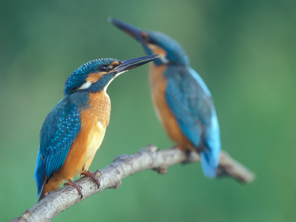
Two common kingfishers with bright blue wings and orange bellies perched on a bare wooden branch against a blurred green background.
A pair of common kingfishers perched on a branch, representative of the avian life found in the Escaut river wetlands.

Réserve naturelle régionale de l'Escaut-rivière history and protected-area timeline

The history of this stretch of the Escaut valley reaches back at least to the Neolithic and Roman periods, but the modern history of the site as a protected natural area is much more recent. The Napoleonic cadastre already shows a largely undeveloped valley floor shaped by long, narrow parcels, evidence of a long tradition of hay production, seasonal pasture and limited riverbank gardening. Toponyms such as Les Prés, Les Foursières and Les Riez testify to old fish ponds, hay meadows and fallow lands along the river.

In the late nineteenth century, the Chenu family acquired the valley-bottom wet meadows and gradually afforested them with fast-growing poplars, creating the estate that became known as the Bois Chenu. A century later, the poplar plantation was largely felled during the First World War, then replanted and managed as a poplar grove until the municipal authority of Proville bought the site in 1984 with support from the Ministry of the Environment.

A first management plan was drafted in 1985 by the French National Forests Office (Office National des Forêts), and an unauthorized clear-cut during the winter of 1994 to 1995 left only scattered stumps and branches. Public reaction was strong, and a new municipal team began a renaturation programme in 1995 based on a restorative management plan. In 1996, a long-term lease allowed a team of seven young workers to restore the remaining 12 hectares of wet meadows, rebuild hedges, dig new ponds and create a public discovery trail.

The Reserve was proposed by the commune in 2007, administratively validated on 10 October 2011 and formally inaugurated on 23 June 2012 after the installation of educational signage and visitor infrastructure. Since then, the reserve has continued to host researchers, students and school groups as a long-term reference site for alluvial forest regeneration and wetland restoration.

Réserve naturelle régionale de l'Escaut-rivière landscape and geographic character

The reserve occupies a long, narrow strip of alluvial floodplain in the Cambrésis plain, with an overall very gentle slope descending from roughly 49 m to 46 m in elevation across the reserve. The microtopography is shaped by the remains of old ditch networks, small ponds and the levees or bourrelets that line the channel, which together constrain the Escaut-rivière's ability to flood and meander freely.

Geologically, the site lies in a floodplain dominated by recent alluvial deposits, with silty, sandy and clay-rich loams covering a Senonian chalk substrate. The plateau above is covered by a thick Pleistocene loess mantle, locally up to ten metres thick and largely responsible for the agricultural richness of the surrounding plain. The floodplain itself alternates between open wet meadows and ditches on the left bank and a developing forest mosaic on the right bank, where the Bois Chenu is crossed by two linear clearings maintained for a high-voltage power line and a gas pipeline.

Hydrologically, the Escaut here is a low-gradient, slow-flowing lowland river, with flows of typically 1 to 3 m³/s outside flood events and a floodplain roughly 700 m wide at Proville. The adjacent canal de Saint-Quentin forms the western boundary, while groundwater levels and the seasonal rise of the water table define much of the landscape's character, producing a humid, often soggy valley floor.
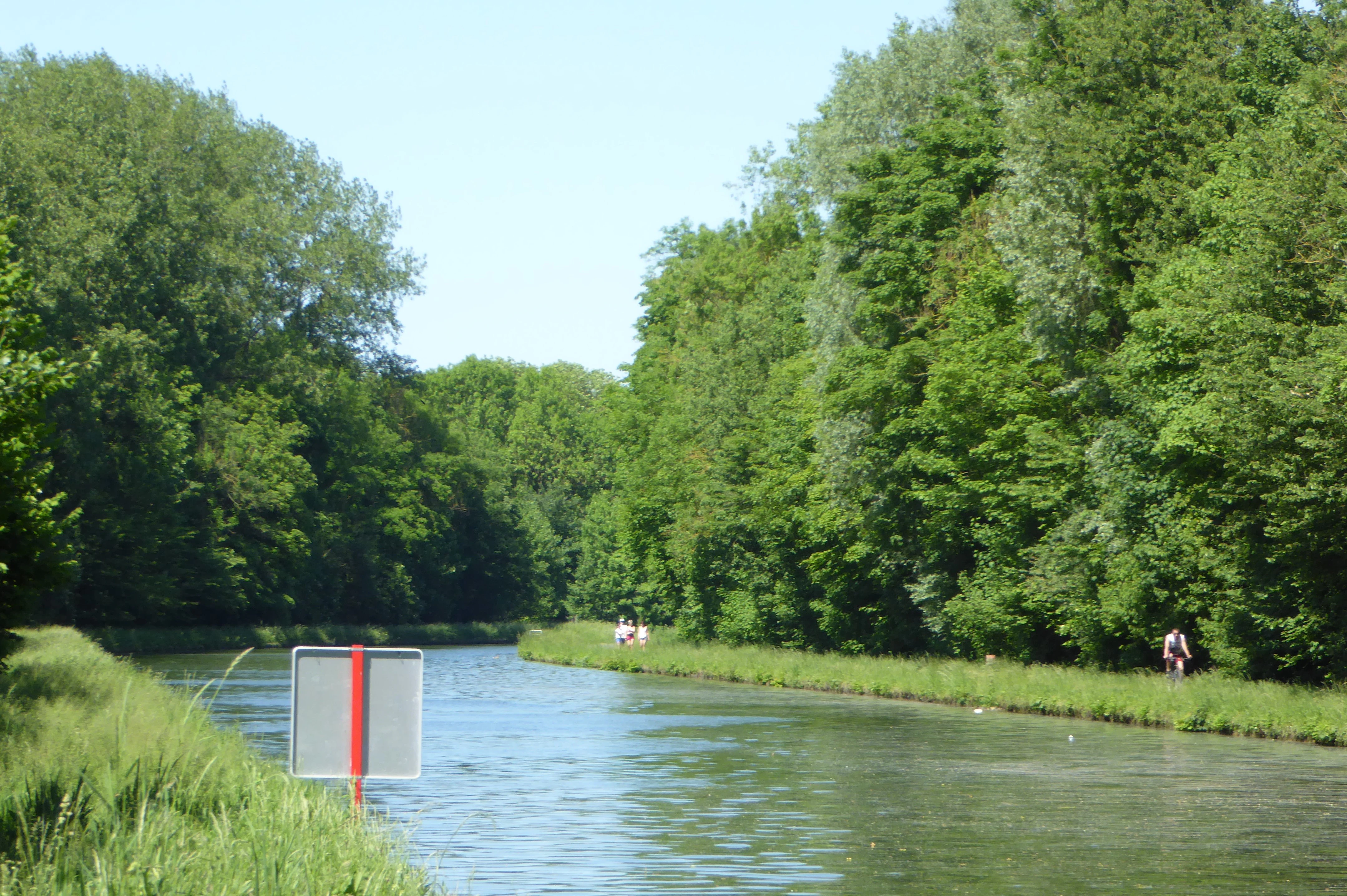
A peaceful canal or river flowing through a lush green forest, with a metal sign visible in the foreground and a grassy towpath on the right.
A view of the Escaut river within the nature reserve, flanked by lush alluvial forest and a grassy bank.

Réserve naturelle régionale de l'Escaut-rivière ecosystems, habitats, and plant life

Ecologically, the reserve is a remarkable example of a temperate alluvial complex that combines three main habitat types: wet meadows maintained by late mowing and extensive grazing on the left bank, a mosaic of marshes, ditches and reedbeds, and a young alluvial woodland in active regeneration on the right bank. The vegetation pattern includes reed communities dominated by Phragmites australis, sedge-dominated caricaies, willow formations, ash-alder forests with bird cherry, and wet meadows associated with Filipendula ulmaria.

Around twenty distinct biotopes have been identified on the site, and the management plan aims to maintain this diversity as the forest continues to evolve naturally. The reserve's botanical interest includes species such as the stream avens (Geum rivale), the sneezewort (Achillea ptarmica), the autumn crocus (Colchicum autumnale), the marsh orchid Dactylorhiza praetermissa, the aquatic buttercup Ranunculus aquatilis and the European white elm (Ulmus laevis). The yellow wood anemone (Anemone ranunculoides), absent for about a century, was rediscovered in the Bois Chenu in 2010.

More broadly, the reserve is part of a broader ecological network that includes the green and blue infrastructure of the Hauts-de-France region and Natura 2000 valleys of the Scarpe and the Escaut further downstream, supporting ecological continuity along one of Europe's major river corridors.

Réserve naturelle régionale de l'Escaut-rivière wildlife and species highlights

By 2012, inventories had identified around 220 animal species on the site, including roughly 25 considered of heritage value, while more than three quarters of the plant formations are themselves of regional heritage interest. The reserve's fauna reflects its mosaic of wet meadows, marshes, reedbeds and forest, with several emblematic groups well represented.

Among the invertebrates, the reserve hosts at least seven dragonfly species of determinant status, including Lestes dryas, Calopteryx virgo, Ischnura pumilio, Coenagrion scitulum, Sympetrum danae and Sympetrum flaveolum, alongside the rare Lesser Purple Emperor butterfly (Apatura ilia), a species characteristic of alluvial woodlands and now very uncommon in northern France. The fish community includes protected pike (Esox lucius), the European eel (Anguilla anguilla) and the bitterling (Rhodeus sericeus), which is essential for the reproduction of native freshwater mussels.

Birds include the Marsh Harrier (Circus aeruginosus), which nests in the reedbeds and is listed on Annex I of the Birds Directive, the Bluethroat (Luscinia svecica), the Water Rail (Rallus aquaticus), the European Kingfisher (Alcedo atthis), the Cetti's Warbler (Cettia cetti) and the Sedge Warbler (Acrocephalus schoenobaenus), along with the recently returned Aquatic Warbler (Acrocephalus paludicola). Molluscs include the European protected Desmoulin's whorl snail (Vertigo moulinsiana). Fungi are also a major component of biodiversity: the Bois Chenu alone supports more than 350 recorded mushroom species, around ten percent of the region's known fungal diversity, with the rare Rhodotus palmatus again observed thanks to the reintroduction of dead wood.

Réserve naturelle régionale de l'Escaut-rivière conservation status and protection priorities

From a conservation standpoint, the reserve protects one of the last large remnants of a habitat type, the alluvial complex of the upper Escaut, that has become among the most threatened in Western Europe. Wetland meadows, marshlands and ash-alder forests of this type were once widespread in northern France floodplains but have been largely eliminated by drainage, agricultural intensification and canalization. Their loss is particularly severe in the Cambrésis, where wetlands now cover less than one percent of the territory.

The reserve combines a strong management role with active ecological restoration. Since the clear-cut of the former poplar grove in 1994, the site has been progressively restored through a renaturation approach that lets natural dynamics drive woodland recovery while using late mowing and extensive grazing to keep meadows open. Dead wood is deliberately retained to support saproxylic species and fungi, and experimental plantations by INRA and the regional forestry centre have compared different silvicultural approaches in alluvial conditions.

Beyond its local value, the reserve contributes to wider conservation frameworks, including the Hauts-de-France regional green and blue infrastructure, the national Trame verte et bleue as a recognized biodiversity reservoir, and the pan-European ecological network. It plays a tangible role in flood regulation, water filtration and climate moderation at the local scale, while serving as a key node on one of Europe's largest fluvial ecological corridors.

Réserve naturelle régionale de l'Escaut-rivière cultural meaning and human context

The reserve occupies a stretch of valley that has supported human activity since at least Neolithic times and was clearly used during the Roman period. The Napoleonic cadastral maps already show a pattern of long, narrow parcels along the Escaut, a typical signature of riverbank hay meadows and small-scale gardening that persisted into the modern era. Old local toponyms such as Les Prés, Les Foursières and Les Riez preserve the memory of a working rural landscape shaped by fishing, haymaking and seasonal grazing.

The Bois Chenu and the adjacent meadows were privately held for generations, most notably by the Chenu family, whose nineteenth- and twentieth-century stewardship shaped the area before public acquisition. The restoration effort that followed has also become a model of participatory conservation: the project received several regional eco-action awards in the late 1990s and early 2000s, and today the site hosts school activities, teacher training by the national education system and an interpretive area named the Espace Chico Mendes.

Top sights and standout views in Réserve naturelle régionale de l'Escaut-rivière

The reserve's standout qualities include its status as the last natural reach of the upper Escaut, its pioneering alluvial forest regenerating spontaneously since 1994, and its role as one of the few wetland biodiversity reservoirs in the historically arid Cambrésis plain. It combines a functioning mosaic of meadows, marshes and woodland on a remarkably small surface area.

Equally notable are its richness in indicator and protected species, including the Marsh Harrier, the European Kingfisher, the Desmoulin's whorl snail and more than 350 fungal species, and its situation within the broader Escaut river corridor, one of Europe's major fluvial biological corridors connecting France, Belgium and the Netherlands.

Best time to visit Réserve naturelle régionale de l'Escaut-rivière

The reserve can be visited year-round along the Chemin Noir walking trail, which crosses the wet meadow sector from east to west, and along the woodland path looping around the Bois Chenu. A footbridge over the Escaut connects the two sides. The site lies in a temperate oceanic-to-transitional climate zone, with relatively low regional rainfall of around 645 mm per year, and water levels generally lower in summer and higher in winter.

Spring and early summer are particularly rewarding for observing the wetland flora, reedbed birds and dragonflies that emerge as temperatures rise. Autumn brings fungal activity and changing woodland colours, while winter offers the highest water levels and the best chance to observe waterbirds and the dynamics of the river's floodplain. Sturdy footwear is recommended in all seasons because much of the ground is regularly saturated.


Monthly climate preview

Long-term representative point measurements tracking monthly temperature ranges and precipitation rates

Réserve naturelle régionale de l'Escaut-rivière Climate Normals And Annual Temperature Rhythm

Representative coordinates record measured monthly temperature ranges and precipitation rates across the annual cycle for Réserve naturelle régionale de l'Escaut-rivière. Examining the complete twelve-month profile provides detailed meteorological context for evaluating long-term environmental patterns.
Annual mean10 °C
3 °C18 °C
Jan
Feb
Mar
Apr
May13°
Jun16°
Jul18°
Aug18°
Sep14°
Oct11°
Nov
Dec
Warmest month
July

17.9 °C

Coolest month
January

2.6 °C

Wettest month
December

2.6 mm/day

Driest month
April

1.5 mm/day

Park location guide

Geography guide, regional context, and park location map for Réserve naturelle régionale de l'Escaut-rivière

Réserve naturelle régionale de l'Escaut-rivière park geography, regions, and map view in France

Understand where Réserve naturelle régionale de l'Escaut-rivière sits in France through a broader geographic reading of the surrounding landscape, nearby location context, and its mapped position within the national park landscape.

How Réserve naturelle régionale de l'Escaut-rivière fits into France

France is a unitary semi-presidential republic and one of the world's largest economies. It borders Belgium, Luxembourg, Germany, Switzerland, Italy, Monaco, Andorra, and Spain, with a maritime border to the United Kingdom. The country is known for its cultural influence, art, cuisine, and political history spanning centuries.

Wider geography shaping Réserve naturelle régionale de l'Escaut-rivière in France

France is located in Western Europe. Metropolitan France extends from the Rhine to the Atlantic Ocean and from the Mediterranean Sea to the English Channel and North Sea. The country borders Belgium, Luxembourg, Germany, Switzerland, Italy, Monaco, Andorra, Spain, and has a maritime border with the United Kingdom.

Map view of Réserve naturelle régionale de l'Escaut-rivière

Use this park location map to pinpoint Réserve naturelle régionale de l'Escaut-rivière in France, understand its exact geographic position, and read its mapped placement within the surrounding landscape more clearly.

Pigeon | © OpenStreetMap contributors

Location context for Réserve naturelle régionale de l'Escaut-rivière

Hauts-de-France

Visualizing alluvial forests, wet meadows, and rare valley floor habitats across the protected Escaut corridor

Réserve naturelle régionale de l'Escaut-rivière Landscapes and Protected Area Photos

Photographic archives capture the varied terrain, slow-flowing river channels, and regenerating woodland habitats defining Réserve naturelle régionale de l'Escaut-rivière. Visual records reveal the distinct ecological character of these protected wetlands within the broader Cambrésis plain.

Two common kingfishers with bright blue wings and orange bellies perched on a bare wooden branch against a blurred green background.

A close up view of a bell-shaped, fuzzy reddish-brown water avens flower hanging downwards against a dark background.

A peaceful canal or river flowing through a lush green forest, with a metal sign visible in the foreground and a grassy towpath on the right.

Park atlas

Compare surrounding valley ecosystems and regional nature reserves across northern France

Parks Near Réserve Naturelle Régionale de l'Escaut-Rivière and Protected Landscapes

Visitors exploring Réserve naturelle régionale de l'Escaut-rivière can examine nearby protected areas and similar alluvial valley ecosystems within the surrounding region. Comparing adjacent lowland habitats and river corridors provides broader geographic context for northern French wetland conservation.
Protected areaNord
About 22 km away#1 closest

Northeast

Vallées de la Scarpe et de l'Escaut Protected Landscape Geography and Map Context

Wetland mosaic, subsidence lakes, and river floodplains in Nord

Examine the physical geography of the Scarpe and Escaut Valleys, a premier wetland site in northern France. The protected area features a mosaic of marshes, wet meadows, and mining-subsidence lakes that provide vital habitats for migratory waterbirds and support carbon storage through rare alkaline peatlands.

Area
276.22 km²
Established
2020
Relief
Lowland
Scope
Terrestrial
Protected areaHauts-de-France
About 23 km away#2 closest

East

Neuvilly Protected Area: Geography, Mapped Boundaries, and Regional Landscape Context

A detailed geographic overview of protected lands in Hauts-de-France.

Gain insights into the Neuvilly protected area through detailed mapping and geographic analysis. This resource provides a clear breakdown of the site footprint and its place within the Hauts-de-France landscape, ensuring a structured understanding of its ecological boundaries and regional significance for mapping and environmental study.

Area
0.193 km²
Established
1990
Climate
Temperate
Scope
Terrestrial
A panoramic watercolor painting showing a winding river in a green meadow, with a line of trees on the right and purple mountains in the background.
Nature reserveHauts-de-France
About 26 km away#3 closest

North

Réserve naturelle régionale de la tourbière de Vred: Protected Peatbog and Wetland Map

Geographic landscape in the Hauts-de-France alluvial plain

Vred Peatbog is an ecologically significant protected site in northern France, known for its floating sphagnum-bearing peat formation. The reserve contains a mosaic of managed drainage channels, reedbeds, and woodlands that provide a critical sanctuary for wetland species within the Scarpe valley landscape. This mapping data provides a detailed look at the site's unique alluvial basin and regional conservation status.

Area
0.41 km²
Established
2008
IUCN
IV
Relief
Lowland
Nature reserveHauts-de-France
About 27 km away#4 closest

North

Réserve naturelle régionale du marais de Wagnonville: Protected Wetland and Bog Geography

A resilient marshland ecosystem in the Douai urban landscape.

This reserve provides a comprehensive look at the surviving wetlands of the Escrebieux valley. Covering 20 hectares, the area hosts a dense variety of habitats from open ponds to rare sphagnum peat bogs, marking an essential node of biodiversity and ecological restoration within the northern French administrative landscape.

Area
0.2 km²
Established
1994
IUCN
IV
Relief
Lowland
Nature reserveHauts-de-France
About 28 km away#5 closest

North

Réserve naturelle régionale des Annelles, Lains et Pont Pinnet: Protected Landscape Geography

A unique biodiversity refuge in the Hauts-de-France region of France.

The Réserve naturelle régionale des Annelles, Lains et Pont Pinnet showcases a dense patchwork of 26 natural habitats across a 14-hectare expanse. Its mapped boundaries reveal a mosaic of wet marshes, coal-shale terrils, and peat-forming ecosystems that support a significant variety of amphibians, dragonflies, and metallophyte flora. This protected area offers a clear look at how industrial landscapes can transition into essential botanical refuges within the northern French coal basin.

Area
0.146 km²
Established
2010
IUCN
IV
Relief
Lowland
Watercolor painting of a soft, hazy landscape featuring low hills in the background and marshy wetlands in the foreground with pastel shades of green, yellow, and soft pink.
Nature reserveHauts-de-France
About 29 km away#6 closest

North

Réserve naturelle régionale du pré des Nonnettes: Regional Nature Reserve and Wetland Atlas

Alluvial marshland and hay meadow terrain in the Hauts-de-France

The Réserve naturelle régionale du pré des Nonnettes preserves a rare wet hay meadow habitat within the Marais du Vivier. Located in the lower Scarpe river valley, this nature reserve integrates marshy ground, ponds, and riparian woods to support a concentrated mosaic of wetland biodiversity. MoriAtlas provides detailed geographic context for this protected site and its significance within the larger Hauts-de-France wetland conservation network.

Area
0.173 km²
Established
2008
IUCN
IV
Relief
Lowland
A watercolor painting showing a soft, panoramic landscape with green hills in the distance, a meandering stream in the foreground, and grassy banks with subtle pink floral highlights.
Nature reserveHauts-de-France
About 38 km away#7 closest

East

Réserve naturelle régionale des Prairies du Val de Sambre: Regional Nature Reserve Atlas

Wetland floodplain meadows in the middle Sambre valley

The Réserve naturelle régionale des Prairies du Val de Sambre protects essential wet grassland habitats in northern France. Spanning approximately 49 hectares along the canalised Sambre, this protected area maintains traditional meadow systems that support wetland-dependent species; it represents a key junction in the regional landscape between the Mormal forest and Thiérache bocage.

Area
0.494 km²
Established
2012
IUCN
IV
A wide watercolor illustration showing a calm river reflecting pink and yellow hues, bordered by green trees and vegetation on both banks.
Nature reserveHauts-de-France
About 43 km away#8 closest

Northeast

Réserve naturelle régionale du bois d'Encade: Protected Woodland and Quarry Mosaic

Regional Nature Reserve in the Hauts-de-France river valley.

Spanning a compact stretch of the Hogneau valley, this nature reserve protects diverse habitats including fern-rich rock crevices and mature forest stands. The site represents a crucial ecological stepping stone that provides refuge for numerous bird, bat, and invertebrate species within a heavily cultivated agricultural corridor of northern France.

Area
0.021 km²
Established
2001
IUCN
IV
Relief
Lowland

Common questions about visiting, size, designation, and location context for Réserve naturelle régionale de l'Escaut-rivière

Réserve naturelle régionale de l'Escaut-rivière FAQs for park facts, access, geography, and protected area context

Find quick answers about Réserve naturelle régionale de l'Escaut-rivière, including protected-area facts, park geography, trail and visitor context, and how the park fits into its surrounding country and regional landscape.
MoriAtlas Explorer

Continue Your Protected Areas Search Across the Global Atlas

Deepen your exploration by continuing the structured search for national parks and protected areas worldwide. Utilize the comprehensive filtering capabilities to compare different conservation landscapes and refine your understanding of global park geography. Discover more about the distribution and characteristics of protected natural areas.

Global natural geography