Mori Atlas logo
Nature reserveRéserve naturelle régionale de la ferme de Choisy

A regional nature reserve defined by pastoral wet meadows, bird migration routes, and reclaimed marshland geography.

Réserve naturelle régionale de la ferme de Choisy: Mapping Protected Wetland Landscapes in the Pays de la Loire

(Réserve naturelle régionale de la ferme de Choisy (RNR261))

Located in the Vendée department, Réserve naturelle régionale de la ferme de Choisy preserves 80 hectares of sub-brackish wet meadows within the historic Marais poitevin marshlands. This protected area functions as a vital refuge for migratory waterbirds and rare botanical species, sustained by traditional mowing and grazing practices. Its flat, low-lying terrain reveals the complex hydrological history of the Atlantic coastal hinterland, offering deep insight into the region's managed pastoral ecosystems.

regional nature reservewet meadowssub-brackish marshlandMarais poitevinVendéePays de la Loire

Réserve naturelle régionale de la ferme de Choisy

Nature reserve

Park overview

Structured park overview, official facts, and landscape profile for Réserve naturelle régionale de la ferme de Choisy

Réserve naturelle régionale de la ferme de Choisy park facts, protected area profile, and essential visitor context

Review the core facts for Réserve naturelle régionale de la ferme de Choisy, including designation, size, terrain, visitor scale, habitats, and operating context in one park-focused overview.

About Réserve naturelle régionale de la ferme de Choisy

The Réserve naturelle régionale de la ferme de Choisy is a regional-level protected natural area in the Pays de la Loire region of western France, embedded within the larger Marais poitevin wetland complex. Although small at about 80 hectares, the reserve represents one of the most characteristic expressions of the human-shaped wet grasslands that define this part of the Atlantic coastal hinterland. Its setting, on reclaimed land that was once part of the historic Chaussées domain, gives the site a layered cultural as well as ecological identity.

Ecologically, the site is distinguished by its sub-brackish meadows, a transitional environment between freshwater marsh and true coastal salt marsh. This character is maintained not by natural tidal influence but by centuries of pastoral practice, including mowing and cattle grazing, which keep the landscape open and prevent scrub encroachment. The result is a mosaic of humid grassland habitats that support a particularly high density of botanical and ornithological interest relative to the reserve's size.

The reserve sits in the commune of Saint-Michel-en-l'Herm in the Vendée department and lies very close to another protected wetland, the national nature reserve of the communal marsh of Saint-Denis-du-Payré. Together, these sites form a small network of protected marshland in an area where wetland conservation has become increasingly important due to long-term drainage and agricultural conversion pressures. The site is administered by the département federation of hunters of Vendée, reflecting the historic role of hunting associations in French wetland stewardship. Management follows a multi-year plan, currently structured around the 2013 to 2018 cycle, with the regional classification renewable every six years.

Quick facts and research context for Réserve naturelle régionale de la ferme de Choisy

The reserve is located in the Vendée department, in the Pays de la Loire region of western France, on the territory of Saint-Michel-en-l'Herm, within the Marais poitevin. It was first established as a voluntary nature reserve (réserve naturelle volontaire) on 6 May 1991 and was reclassified as a regional nature reserve on 19 November 2012, with a classification period of six years renewable.

It covers about 80 hectares of sub-brackish wet meadows maintained by mowing and cattle grazing, similar in ecological character to salt marshes. The site supports 137 flowering plant species and at least 142 bird species, along with amphibians such as the agile frog and European tree frog, and mammals including the European otter. It is managed by the Fédération départementale des chasseurs de Vendée under a management plan covering 2013 to 2018.

Protection and recognition

Review documented terrestrial protection scope, designation year, and international recognition records.

Protection Status and Designation History for Réserve naturelle régionale de la ferme de Choisy

Terrestrial protection status for Réserve naturelle régionale de la ferme de Choisy is documented alongside official designation history established in 2012. Records outline the designated management scope and available international recognition sources for this protected natural area.

Protection details

Protection scope
Terrestrial
Designated year
2012
Transboundary protection
No
WDPA ID
555559613
Park context

Deeper park guide and search-rich context for Réserve naturelle régionale de la ferme de Choisy

Réserve naturelle régionale de la ferme de Choisy history, landscape, wildlife, and travel context

Explore Réserve naturelle régionale de la ferme de Choisy through its history, landscape character, ecosystems, wildlife, conservation priorities, cultural context, and seasonal travel timing in a structured park guide built for atlas discovery and search intent.

Why Réserve naturelle régionale de la ferme de Choisy stands out

The reserve is best known for its sub-brackish wet meadows that mimic the ecological character of salt marshes, sustained by traditional mowing and cattle grazing rather than salinity. These pastoral wetlands form a key habitat for waterbirds, functioning simultaneously as a wintering site, a migratory stopover, and a breeding area within the Marais poitevin. Its birdlife diversity is a defining feature: the reserve hosts more than 140 recorded bird species, including greylag goose, wigeon, teal, golden plover, black-tailed godwit, black tern, common redshank, and black-winged stilt. Botanically, the wet meadows also shelter rare plants such as the ophioglossus-leaved buttercup, starfruit, and Iris spuria, reinforcing the reserve's reputation as a compact but ecologically rich wetland refuge.

Réserve naturelle régionale de la ferme de Choisy history and protected-area timeline

The land on which the reserve sits has a long history shaped by human engagement with the coastal marshes. The site once belonged to the historic Chaussées domain, an area of land reclaimed from the sea around the 12th century. In 1850, this domain was divided into three separate farming operations, fragmenting the landscape into smaller agricultural holdings that today form the broader matrix around the reserve.

The reserve itself began as a hunting reserve under the ownership of the Fédération départementale des chasseurs de Vendée. Its formal protection history began on 6 May 1991, when it was designated as a réserve naturelle volontaire, an early French designation for privately or locally driven conservation sites. Following changes in French nature protection law, the site was reclassified by decision of the Regional Council on 19 November 2012 as a full réserve naturelle régionale, a status conferring stronger and more durable legal protection. The classification was granted for an initial period of six years, subject to renewal, marking a new chapter in the long history of human management of these reclaimed marshes.

Réserve naturelle régionale de la ferme de Choisy landscape and geographic character

The reserve occupies a flat expanse of reclaimed coastal plain within the Marais poitevin, a vast wetland region shaped over centuries by drainage channels, embankments, and agricultural use. At about 80 hectares, the site is a relatively small but well-defined portion of this larger marshland matrix. The terrain is low-lying and open, dominated by wet meadows traversed by a network of ditches and small water channels that recall the engineered hydrology of the surrounding marshlands.

Although technically inland, the meadows carry a sub-brackish character that visually and ecologically resembles coastal salt marsh habitat. This affinity is not incidental: the broader Marais poitevin was once connected to marine influence, and the soils here retain traces of salinity and hydrological patterns typical of transitional coastal wetlands. The result is a damp, treeless pastoral landscape framed by embankments and watercourses, an understated but visually distinctive environment within the Atlantic coastal marshlands of western France.

Réserve naturelle régionale de la ferme de Choisy ecosystems, habitats, and plant life

Ecologically, the reserve belongs to the family of sub-brackish wet meadows that fringe the Atlantic coast of France. The habitat is maintained in an open state by traditional agricultural practices, particularly mowing and cattle grazing, which mimic the disturbance regimes that shaped similar coastal grasslands elsewhere. Without this management, the meadows would rapidly succeed toward scrub or woodland, losing their value for ground-nesting birds and specialised wetland flora.

The vegetation is botanically diverse for such a small area, with 137 species of flowering plants recorded. Among these are several species of conservation interest, including the ophioglossus-leaved buttercup, starfruit, Iris spuria, small-flowered bittercress, hornwort, and Micheli's clover. These plants are closely associated with seasonal flooding, nutrient-rich wet soils, and the open structure maintained by grazing, making the reserve a useful reference site for understanding sub-brackish grassland ecology in the Marais poitevin.

Réserve naturelle régionale de la ferme de Choisy wildlife and species highlights

The reserve is primarily recognised for its birdlife, with 142 bird species recorded using the site. The wet meadows function simultaneously as a wintering area, a migratory stopover, and a breeding habitat, allowing the reserve to play multiple roles across the annual cycle. In winter, the site hosts flocks of greylag goose, Eurasian wigeon, and common teal, while migratory passages bring golden plover, black-tailed godwit, black tern, common redshank, and black-winged stilt through its meadows and channels.

Beyond birds, the reserve supports a notable amphibian community, including agile frog, European tree frog, and natterjack toad, reflecting the network of ditches and seasonal pools that intersect the meadows. The European otter is also recorded as a visitor to the site, using the watercourses that connect the reserve to the wider marshland hydrology. Together, these groups illustrate how the reserve's combination of open wet habitat and connected water network supports a broad slice of wetland fauna.

Réserve naturelle régionale de la ferme de Choisy conservation status and protection priorities

The reserve's conservation significance lies in its preservation of a working pastoral wetland in a region where such landscapes are under sustained pressure from drainage, agricultural intensification, and land-use change. By anchoring traditional mowing and grazing as ongoing management practices, the reserve maintains a living example of sub-brackish meadow habitat rather than a static, abandoned site, a model increasingly valued in European wetland conservation.

Within the Marais poitevin, the reserve contributes to a wider conservation network alongside the nearby national nature reserve of Saint-Denis-du-Payré. Its regional designation, classified by the Conseil régional in 2012, provides a renewable legal protection framework that locks in habitat continuity for six-year periods. The involvement of the local hunters' federation as manager also reflects a feature of French conservation practice, in which local land users play a central role in sustaining protected wetlands across generations.

Réserve naturelle régionale de la ferme de Choisy cultural meaning and human context

The reserve sits within a landscape whose human history stretches back nearly a millennium. The site was once part of the Chaussées domain, reclaimed from the sea during the Middle Ages, a deliberate project of polder creation that transformed coastal estuarine land into productive farmland. The 1850 division of this domain into three separate farms established the pattern of small, family-scale pastoral holdings that continues to influence land use here.

The ongoing practice of cattle grazing and haymaking on the reserve's meadows is therefore not merely an ecological tool but a continuation of centuries-old land stewardship. This rural cultural heritage, embedded in the marshland identity of the Vendée and the wider Marais poitevin, gives the reserve a dual significance, ecological and cultural, as a fragment of reclaimed marshland kept alive through traditional use.

Top sights and standout views in Réserve naturelle régionale de la ferme de Choisy

A compact regional nature reserve of about 80 hectares centred on sub-brackish wet meadows within the Marais poitevin, maintained by mowing and cattle grazing. Hosts more than 140 bird species across wintering, migratory, and breeding seasons, alongside a botanical inventory of 137 flowering plants. Located in Saint-Michel-en-l'Herm, Vendée, and closely associated with the neighbouring national nature reserve of Saint-Denis-du-Payré in a network of protected marshlands on France's Atlantic coast.

Best time to visit Réserve naturelle régionale de la ferme de Choisy

The reserve changes character with the seasons, reflecting its strong ornithological role. In winter, the wet meadows fill with flocks of geese, ducks, and waders seeking refuge in the mild Atlantic coastal climate, making the site a particularly rewarding season for waterbird observation. Spring brings migratory passage and the return of breeding species, while the open meadows and ditches become active with amphibians and the visible flowering of wetland plants. Summer and autumn, marked by traditional haymaking and cattle grazing, sustain the open habitat structure that defines the reserve year-round.
Monthly climate preview

Long-term monthly temperature averages and precipitation statistics for this protected area

Réserve naturelle régionale de la ferme de Choisy Climate Normals and Annual Weather Patterns

Historical climate data recorded at a representative coordinate reveals measured annual temperature fluctuations and monthly precipitation rhythms across the protected landscape. Examining the full twelve-month profile provides detailed meteorological context for tracking long-term environmental patterns.
Annual mean12 °C
6 °C20 °C
Jan
Feb
Mar
Apr11°
May14°
Jun18°
Jul20°
Aug20°
Sep17°
Oct13°
Nov
Dec
Warmest month
August

19.6 °C

Coolest month
January

5.9 °C

Wettest month
November

3.2 mm/day

Driest month
July

1.5 mm/day

Park location guide

Geography guide, regional context, and park location map for Réserve naturelle régionale de la ferme de Choisy

Réserve naturelle régionale de la ferme de Choisy park geography, regions, and map view in France

Understand where Réserve naturelle régionale de la ferme de Choisy sits in France through a broader geographic reading of the surrounding landscape, nearby location context, and its mapped position within the national park landscape.

How Réserve naturelle régionale de la ferme de Choisy fits into France

France is a unitary semi-presidential republic and one of the world's largest economies. It borders Belgium, Luxembourg, Germany, Switzerland, Italy, Monaco, Andorra, and Spain, with a maritime border to the United Kingdom. The country is known for its cultural influence, art, cuisine, and political history spanning centuries.

Wider geography shaping Réserve naturelle régionale de la ferme de Choisy in France

France is located in Western Europe. Metropolitan France extends from the Rhine to the Atlantic Ocean and from the Mediterranean Sea to the English Channel and North Sea. The country borders Belgium, Luxembourg, Germany, Switzerland, Italy, Monaco, Andorra, Spain, and has a maritime border with the United Kingdom.

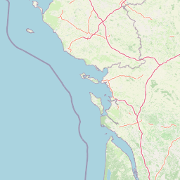
Map view of Réserve naturelle régionale de la ferme de Choisy

Use this park location map to pinpoint Réserve naturelle régionale de la ferme de Choisy in France, understand its exact geographic position, and read its mapped placement within the surrounding landscape more clearly.

Pigeon | © OpenStreetMap contributors

Location context for Réserve naturelle régionale de la ferme de Choisy

Pays de la Loire
Park atlas

Compare adjacent wetland reserves and protected landscapes across the Atlantic coastal hinterland

Parks Near Réserve naturelle régionale de la ferme de Choisy and Surrounding Marshlands

Discover protected areas and wetland reserves located near Réserve naturelle régionale de la ferme de Choisy in the historic Marais poitevin marshlands. Comparing these adjacent regional habitats provides broader geographic context for wetland conservation networks in western France.
A horizontal watercolor painting depicting a winding river or lagoon flowing through rolling green hills and wetlands.
Nature reserveVendée
About 8.4 km away#1 closest

Southwest

Réserve naturelle nationale de la casse de la Belle-Henriette: Geography and Protection

Coastal lagoon and dune habitat atlas in Vendée

Covering a narrow strip of the Atlantic coast, Réserve naturelle nationale de la casse de la Belle-Henriette protects essential marine lagoon and saltmarsh habitats. This data set explores the reserve's shifting dune morphology and its significance as a migratory bird corridor within the broader coastal geography of the Pays de la Loire region.

Area
3.37 km²
Established
2011
IUCN
IV
Relief
Lowland
Watercolor painting of a wetland landscape featuring grassy banks, calm water, and soft rolling hills in the background.
Nature reservePays de la Loire
About 12 km away#2 closest

East

Réserve naturelle régionale du marais de la Vacherie: Protected Wetland Geography and Maps

Ecological mosaic of the Marais poitevin in Pays de la Loire

The Réserve naturelle régionale du marais de la Vacherie protects a high-quality fragment of historical marshland. Defined by flat terrain, winter-flooded depressions, and a complex system of drainage channels, the site serves as a crucial habitat for rare wetland flora and migratory waterbirds. This protected landscape offers insight into the sediment-rich, gently undulating terrain that characterizes the back-marsh zones of the Atlantic seaboard.

Area
1.81 km²
Established
2008
IUCN
IV
Relief
Lowland
Nature reservePays de la Loire
About 26 km away#3 closest

East

Réserve naturelle régionale du marais communal du Poiré-sur-Velluire Regional Nature Reserve

Mapping wetland biodiversity in the Pays de la Loire region

Spanning over 240 hectares of reclaimed marshland, this protected area stands as a unique ecological stronghold in France. The reserve demonstrates how traditional collective land management sustains a rich mosaic of freshwater and brackish habitats, supporting more than 177 bird species and heritage livestock breeds in an expansive, open terrain.

Area
2.41 km²
Established
2012
IUCN
IV
Scope
Terrestrial
Nature reserveNouvelle-Aquitaine
About 58 km away#4 closest

East

Réserve naturelle régionale du marais de Galuchet et des boucles de la Sèvre Niortaise Geography and Map

Urban protected wetland in the Nouvelle-Aquitaine region of France

This urban nature reserve protects 151 hectares of diverse wetland habitats along the Sèvre Niortaise. The landscape is defined by river meanders, wet meadows, and riparian corridors, making it a critical site for regional biodiversity and urban ecological connectivity in the Deux-Sèvres department.

Area
1.51 km²
Established
2025
IUCN
IV
Relief
Lowland
Nature reserveDeux-Sèvres
About 69 km away#5 closest

East

Réserve naturelle régionale du bocage des Antonins: Protected Landscape and Geographic Atlas

Detailed ecological mapping of the Gâtine armoricaine countryside

The Réserve naturelle régionale du bocage des Antonins occupies a distinct space in the Deux-Sèvres department. This protected area serves as a repository for the traditional bocage countryside, featuring a complex arrangement of pollarded trees, wet meadows, and the historic étang des Forges. The site offers a significant look at the structural history of rural western France through its preserved environmental matrix.

Area
0.226 km²
Established
2015
IUCN
IV
Relief
Lowland
Nature reserveNouvelle-Aquitaine
About 72 km away#6 closest

South

Réserve naturelle régionale de la Massonne: Geographic Atlas and Protected Area Map

Mapped ecosystems within the Nouvelle-Aquitaine marshlands

Réserve naturelle régionale de la Massonne serves as a significant ecological corridor in western France, defined by its abrupt transition from coastal Brouage marshes to acidic heath. This atlas entry provides essential data on the reserve boundaries, mapped terrain types, and the structural diversity of its protected wetlands and shrublands, highlighting its role as a sanctuary for diverse nocturnal fauna.

Area
2.023 km²
Established
1997
IUCN
IV
Relief
Lowland
Nature reservePays de la Loire
About 75 km away#7 closest

North

Réserve naturelle régionale du bocage humide des Cailleries: Protected Landscape and Regional Map

Wet bocage and oak woodland in the Lake Grand-Lieu watershed

Covering roughly 18 hectares, this protected area features a fine-textured mosaic of woody hedgerows, wet meadows, and multiple small ponds. The site acts as a functional refuge for varied flora and fauna, illustrating the traditional Atlantic landscape character within western France through its structured management of meadows and pond systems.

Area
0.182 km²
Established
2012
IUCN
IV
Relief
Lowland
Nature reserveRomania
About 83 km away#8 closest

Northwest

Réserve naturelle régionale des marais du Bout de Sac: Protected Marsh Geography

Coastal wetland habitat and protected marshland terrain

The Réserve naturelle régionale des marais du Bout de Sac represents 187.1 hectares of preserved wetland habitat. Its landscape includes reclaimed polders, wet meadows, and a network of tidal channels. This site offers significant value for understanding the ecological structure of coastal marshlands and their role as habitats for waterbird populations near the Atlantic interface.

Established
2025
Relief
Lowland
Water
Water-dominated

Common questions about visiting, size, designation, and location context for Réserve naturelle régionale de la ferme de Choisy

Réserve naturelle régionale de la ferme de Choisy FAQs for park facts, access, geography, and protected area context

Find quick answers about Réserve naturelle régionale de la ferme de Choisy, including protected-area facts, park geography, trail and visitor context, and how the park fits into its surrounding country and regional landscape.
MoriAtlas Explorer

Continue Your Protected Areas Search Across the Global Atlas

Deepen your exploration by continuing the structured search for national parks and protected areas worldwide. Utilize the comprehensive filtering capabilities to compare different conservation landscapes and refine your understanding of global park geography. Discover more about the distribution and characteristics of protected natural areas.

Global natural geography