
Mori Atlas logo
Nature reserveRéserve naturelle régionale de la grotte des Sadoux

Examining the ecological boundaries and habitat mosaic of this specialized Drôme conservation zone

Réserve naturelle régionale de la grotte des Sadoux: A Protected Karst Cave and Woodland Landscape in Auvergne-Rhône-Alpes

(Réserve naturelle régionale de la grotte des Sadoux (RNR80))

The Réserve naturelle régionale de la grotte des Sadoux sits on a steep, east-facing coteau within the forested hills of the Diois in the southern Drôme. Spanning approximately 30 hectares, this protected area preserves a 300-meter-long cave system that serves as a critical maternity and hibernation site for multiple bat species. The surrounding terrain features a diverse mosaic of limestone rocky outcrops, garrigue vegetation, and Mediterranean-influenced woodlands of pubescent oak and Scots pine, which form a vital connected foraging environment for the resident chiroptera populations.

caveskarstbatschiropteraregional nature reserveDrôme
A digital illustration featuring a mountainous landscape with a small waterfall, evergreen trees in the foreground, and layers of rock formations under a soft sky.

Réserve naturelle régionale de la grotte des Sadoux

Nature reserve

Park overview

Structured park overview, official facts, and landscape profile for Réserve naturelle régionale de la grotte des Sadoux

Réserve naturelle régionale de la grotte des Sadoux park facts, protected area profile, and essential visitor context

Review the core facts for Réserve naturelle régionale de la grotte des Sadoux, including designation, size, terrain, visitor scale, habitats, and operating context in one park-focused overview.

About Réserve naturelle régionale de la grotte des Sadoux

The Réserve naturelle régionale de la grotte des Sadoux is a compact protected area in southeastern France whose identity is shaped almost entirely around a single ecological priority: safeguarding a cave that is biologically important for bats. Located on a steep hillside above the petite vallée de la Courance, the reserve links the protection of an underground roost with the conservation of the surface habitats that the animals depend on for feeding.

The cave itself is approximately 300 meters long and opens on an east-facing coteau, an orientation that strongly influences its internal microclimate and its suitability for bat hibernation and reproduction. The reserve's perimeter of about 30 hectares wraps around the cave entrance and extends into the surrounding forested slopes of the forêt domaniale de la Roanne, ensuring that foraging habitat is not separated from the sheltering cavity.

In ecological and administrative terms, the site is unusual in France for its single-species focus: while many regional nature reserves are defined by broader landscapes, the Sadoux reserve exists essentially to maintain a quiet, undisturbed environment around a known chiroptera site. This narrow but vital mandate has shaped every aspect of its management, from year-round access restrictions to the cooperative role of foresters and conservationists in guarding the cave.

Quick facts and research context for Réserve naturelle régionale de la grotte des Sadoux

The Réserve naturelle régionale de la grotte des Sadoux lies in the commune of Pradelle, in the Diois area of the Drôme department, at about 840 meters in altitude within the forêt domaniale de la Roanne. The reserve covers approximately 30 hectares, centered on an east-facing cave of roughly 300 meters in length, set on a steep coteau overlooking the vallée de la Courance.

Administratively it is a regional nature reserve (RNR80) classified by decision on 22 January 2010, following an earlier designation as a voluntary nature reserve in 1991. It is also part of the Natura 2000 site "Grotte à chauves-souris des Sadoux," covering about 1,316 hectares, and falls within a ZNIEFF of type I for the Vallée de la Courance.

Protection and recognition

Explore documented terrestrial protection scopes and official registry records for this protected landscape.

Réserve naturelle régionale de la grotte des Sadoux Protection Status and Mapped Protected Area Records

Terrestrial protection status records outline the official designation framework and boundary parameters established for Réserve naturelle régionale de la grotte des Sadoux. Global registry entries assemble verified conservation parameters to support detailed park research and geographical analysis.

Protection details

Protection scope
Terrestrial
Transboundary protection
No
WDPA ID
555514337
Park context

Deeper park guide and search-rich context for Réserve naturelle régionale de la grotte des Sadoux

Réserve naturelle régionale de la grotte des Sadoux history, landscape, wildlife, and travel context

Explore Réserve naturelle régionale de la grotte des Sadoux through its history, landscape character, ecosystems, wildlife, conservation priorities, cultural context, and seasonal travel timing in a structured park guide built for atlas discovery and search intent.

Why Réserve naturelle régionale de la grotte des Sadoux stands out

The reserve is best known as a critical underground refuge for cave-dwelling bats, particularly the Schreibers' long-fingered bat (Minioptère de Schreibers), the greater mouse-eared bat, and the lesser mouse-eared bat, which use the cave as an important breeding site. Other notable chiroptera documented here include the greater horseshoe bat, the lesser horseshoe bat, the Mediterranean horseshoe bat, and the Western barbastelle. Beyond its cave fauna, the reserve is also recognized for the way its surrounding woodlands, garrigue, and rocky slopes function as a connected foraging landscape for these bat populations, making the protection of both the cavity and its habitat envelope essential.
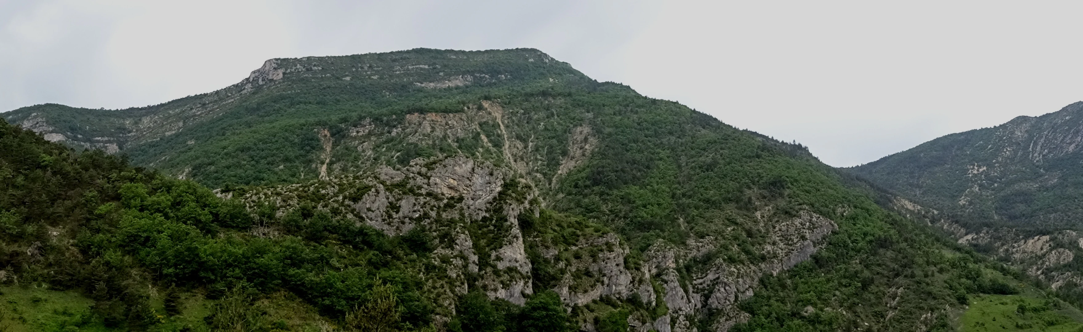
A wide panoramic landscape shot showing a rocky limestone mountain slope covered in green forest vegetation under a cloudy sky.
Panoramic view of the Courance Valley, home to the Grotte des Sadoux.

Réserve naturelle régionale de la grotte des Sadoux history and protected-area timeline

The site was first given formal protection in 1991 as a réserve naturelle volontaire, an older French designation that allowed private or communal owners to commit to conservation management on a voluntary basis. That early status laid the groundwork for stronger, regionally backed protection.

On 22 January 2010, the site was officially reclassified as a réserve naturelle régionale, deepening its legal protection and transferring oversight to regional authorities. It was also folded into the Natura 2000 network in 2014 through the designation "Grotte à chauves-souris des Sadoux," and is additionally recognized within the national ZNIEFF inventory for the Vallée de la Courance.

Réserve naturelle régionale de la grotte des Sadoux landscape and geographic character

The reserve sits on a steep, east-facing coteau above the Courance valley, within the forested hills of the Diois in the southern Drôme. The topography is shaped by limestone slopes interrupted by rocky outcrops, scrubby garrigue patches, and stretches of Mediterranean-influenced woodland that give the area a transitional character between mountain and southern woodland landscapes.

The cave that gives the reserve its name opens directly into this hillside, and its 300-meter-long subterranean gallery reflects the karstic geology of the region. Above ground, the relief alternates between denser forest stands of pubescent oak and Scots pine and more open, rocky terrain, producing the type of edge-rich mosaic that is highly favorable for insect-rich bat foraging grounds.

Réserve naturelle régionale de la grotte des Sadoux ecosystems, habitats, and plant life

Ecologically, the Réserve naturelle régionale de la grotte des Sadoux is a dual system, combining a subterranean cavity with the Mediterranean-margin vegetation that surrounds its entrance. The habitats within the reserve include garrigue communities, rocky slopes, and oak-pine woodlands characteristic of the transitional landscapes between the Alps and Provence.

These surface habitats are valued not as scenic environments but as foraging territory for bats emerging from the cave. The combination of sheltered underground conditions and a varied, insect-rich surface landscape is precisely what makes the site functional as a long-term bat refuge, and it is the reason protection extends beyond the cave mouth itself into the surrounding forest parcel.

Réserve naturelle régionale de la grotte des Sadoux wildlife and species highlights

Wildlife interest at the Sadoux reserve is dominated by bats, and specifically by cave-dwelling chiroptera. The cave serves as a major breeding site for Schreibers' long-fingered bat, the greater mouse-eared bat, and the lesser mouse-eared bat, three species of European conservation concern.

Additional species recorded at the site include the greater horseshoe bat, the lesser horseshoe bat, the Mediterranean horseshoe bat, and the Western barbastelle. Because all of these species are highly vulnerable to disturbance during hibernation and the maternity period, the reserve's strict access rules effectively serve as its primary wildlife protection tool.

Réserve naturelle régionale de la grotte des Sadoux conservation status and protection priorities

The reserve's conservation significance is narrowly targeted but regionally meaningful: protecting a known bat cave and its connected foraging landscapes in a region where cave-dwelling chiroptera face widespread pressures. The site's 2014 inclusion in the Natura 2000 network, via the "Grotte à chauves-souris des Sadoux" zone of about 1,316 hectares, broadened the conservation envelope well beyond the original 30-hectare reserve.

Management is shared between the Office National des Forêts (ONF) Drôme Ardèche, which oversees the forested estate, and the Ligue pour la Protection des Oiseaux (LPO) Drôme, which brings ornithological and general naturalist expertise. This joint stewardship reflects the dual nature of the site: a forest ecosystem wrapped around a highly sensitive underground refuge whose quietness must be preserved across both the hibernation and reproduction seasons.

Top sights and standout views in Réserve naturelle régionale de la grotte des Sadoux

The defining feature of the Sadoux reserve is not a sweeping landscape but a quiet, carefully protected cave used as a maternity and hibernation site by multiple threatened bat species, including Schreibers' long-fingered bat and the greater and lesser mouse-eared bats.

Equally distinctive is the way the reserve binds a 30-hectare forested coteau to a much larger Natura 2000 bat cave zone, producing one of the Drôme's more targeted examples of cave-and-habitat conservation. Strict public access rules reinforce the site's identity as a conservation-first, rather than a visitor-facing, reserve.

Best time to visit Réserve naturelle régionale de la grotte des Sadoux

Because the reserve is closed to the public to avoid disturbing bat colonies during hibernation and reproduction, there is no traditional season for visitation. For general awareness or educational contexts, late spring and summer are typically the months when bat populations are most active above ground elsewhere in the region, but the site itself remains off-limits and its value lies in undisturbed protection rather than visitor access.
Monthly climate preview

Long-term representative temperature ranges and precipitation patterns across the protected terrain

Annual Climate Normals and Weather by Month for Réserve naturelle régionale de la grotte des Sadoux

Representative coordinate records show measured monthly temperature variations alongside steady precipitation averages throughout the year. Examining the full twelve-month profile provides complete climate data for comparative analysis across the protected area.
Annual mean12 °C
2 °C22 °C
Jan
Feb
Mar
Apr10°
May15°
Jun19°
Jul22°
Aug22°
Sep17°
Oct12°
Nov
Dec
Warmest month
July

22.3 °C

Coolest month
January

2.5 °C

Wettest month
November

3.3 mm/day

Driest month
July

1.3 mm/day

Park location guide

Geography guide, regional context, and park location map for Réserve naturelle régionale de la grotte des Sadoux

Réserve naturelle régionale de la grotte des Sadoux park geography, regions, and map view in France

Understand where Réserve naturelle régionale de la grotte des Sadoux sits in France through a broader geographic reading of the surrounding landscape, nearby location context, and its mapped position within the national park landscape.

How Réserve naturelle régionale de la grotte des Sadoux fits into France

France is a unitary semi-presidential republic and one of the world's largest economies. It borders Belgium, Luxembourg, Germany, Switzerland, Italy, Monaco, Andorra, and Spain, with a maritime border to the United Kingdom. The country is known for its cultural influence, art, cuisine, and political history spanning centuries.

Wider geography shaping Réserve naturelle régionale de la grotte des Sadoux in France

France is located in Western Europe. Metropolitan France extends from the Rhine to the Atlantic Ocean and from the Mediterranean Sea to the English Channel and North Sea. The country borders Belgium, Luxembourg, Germany, Switzerland, Italy, Monaco, Andorra, Spain, and has a maritime border with the United Kingdom.

Map view of Réserve naturelle régionale de la grotte des Sadoux

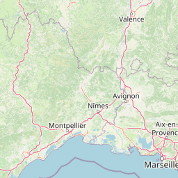
Use this park location map to pinpoint Réserve naturelle régionale de la grotte des Sadoux in France, understand its exact geographic position, and read its mapped placement within the surrounding landscape more clearly.

Pigeon | © OpenStreetMap contributors

Location context for Réserve naturelle régionale de la grotte des Sadoux

Auvergne-Rhône-Alpes

Visualizing the rocky coteau slopes, woodlands, and protected habitats of the reserve

Réserve naturelle régionale de la grotte des Sadoux Photos and Landscape Views

Visual records capture the steep limestone topography, garrigue patches, and oak woodlands defining the protected environment around the subterranean bat habitat. Examining these landscape photographs provides concrete insight into the terrain and ecological mosaic of Réserve naturelle régionale de la grotte des Sadoux.

A wide panoramic landscape shot showing a rocky limestone mountain slope covered in green forest vegetation under a cloudy sky.

Park atlas

Compare nearby regional reserves, forested coteau terrain, and karst habitats in southeastern France

Parks Near Réserve Naturelle Régionale de la Grotte des Sadoux and Surrounding Protected Areas

Browse protected areas and forested natural reserves located near Réserve naturelle régionale de la grotte des Sadoux to evaluate regional conservation landscapes. Comparing adjacent limestone habitats and wildlife zones provides deeper geographical context for the surrounding Diois hills.
Nature reserveAuvergne-Rhône-Alpes
About 17 km away#1 closest

West

Réserve naturelle régionale du réseau de grottes à chauves-souris en Drôme et en Ardèche: Protected Area Overview

Subterranean habitat protection within the Auvergne-Rhône-Alpes regional geography.

This regional nature reserve secures vital karst cavities serving as essential refuges for multiple bat species. By bridging administrative boundaries in southeastern France, the protected area demonstrates a precise focus on underground ecology and the preservation of irreplaceable subterranean environments across the departments of Drôme and Ardèche.

Area
0.49 km²
Established
2019
IUCN
IV
Relief
Mixed relief
A watercolor illustration of a serene landscape with rolling hills, a meandering river, and soft light.
Regional parkAuvergne-Rhône-Alpes
About 47 km away#2 closest

West

Parc naturel régional des Monts d'Ardèche: Protected Landscapes and Geographic Map Context

Volcanic highland terrain within the Auvergne-Rhône-Alpes region

Covering over 248,000 hectares, Parc naturel régional des Monts d'Ardèche represents a significant protected area in the southern Massif Central. The region is marked by its distinctive volcanic sucs, including Mont Gerbier-de-Jonc, and a complex network of Cévenol river valleys. It remains a focal point for understanding the transition between high volcanic plateaus and traditional terraced agricultural slopes in southeastern France.

Area
2,280 km²
Established
2001
IUCN
V
A soft watercolor illustration depicting layered rolling hills, distant mountain silhouettes, and clusters of trees in a pale color palette.
Regional parkProvence-Alpes-Côte d'Azur
About 58 km away#3 closest

South

Parc naturel régional du Luberon: Regional Park Boundaries and Protected Landscape Atlas

Geology, mountain ridges, and Mediterranean ecosystems of Provence

Parc naturel régional du Luberon serves as a vital protected corridor in southeastern France. The park features three parallel limestone massifs, dramatic ochre formations, and fossil-rich plateaus. Its geography offers a case study in integrating sustainable land use with rich biodiversity across the Vaucluse and Alpes-de-Haute-Provence departments.

Area
1,747.26 km²
Established
1977
IUCN
V
Visitors
350K annual
Watercolor illustration showing mountains, a winding river, and pine trees in a landscape
National parkFrance
About 62 km away#4 closest

East

Écrins National Park: Alpine Glaciated Terrain and Protected Landscape Details

Mapped boundaries and regional geography of a major French National Park.

Delve into Écrins National Park, a defining national park within the French Alps. This page provides a comprehensive overview of its protected landscape, focusing on its dramatic glaciated terrain, significant peaks such as the Barre des Écrins, and its position within the regional geographic context. Explore the mapped extent and understand the unique alpine environment of this protected area.

Area
925 km²
Established
1973
IUCN
II
Visitors
800K annual
A soft watercolor painting depicting a winding river through a lush green valley with distant hills in the background.
Nature reserveAuvergne-Rhône-Alpes
About 63 km away#5 closest

Northeast

Réserve naturelle régionale des Isles du Drac: Braided River Landscape and Regional Map Context

A vital riverine conservation corridor in the Auvergne-Rhône-Alpes region of France

The Réserve naturelle régionale des Isles du Drac occupies an expansive alluvial floodplain where the river transitions into a braided system. This reserve preserves dynamic gravel bars and woodland habitats that support exceptional biodiversity within the northern Alpine landscape. It offers a detailed look at how riverine corridors persist alongside significant hydroelectric and industrial infrastructure in the Grenoble area.

Area
8.048 km²
Established
2009
IUCN
IV
Relief
Lowland
Nature reserveProvence-Alpes-Côte d'Azur
About 63 km away#6 closest

South

Réserve naturelle régionale Ermitage-Escampeaux: A Protected Landscape in the Vaucluse Department

Mapping regional nature reserves within inland Provence-Alpes-Côte d'Azur.

Located in the Villes-sur-Auzon commune, the Réserve naturelle régionale Ermitage-Escampeaux stands as a significant addition to the protected lands of Provence-Alpes-Côte d'Azur. This 252.9-hectare reserve offers a focused look at the transition between Mediterranean garrigue and the higher Provençal uplands, providing essential habitat conservation within a traditional rural mosaic.

Area
2.529 km²
Established
2026
IUCN
IV
A soft watercolor illustration featuring rolling green hills, a winding path, and distant mountain ridges in a muted, painterly style.
Nature reserveFrance
About 67 km away#7 closest

Northeast

Réserve naturelle nationale de la haute vallée du Béranger: Mountain Protected Area Map

Tracing the alpine terrain and torrent corridors in the French Alps.

Covering roughly 84 hectares in the Isère region, this nature reserve integrates traditional pastoral landscapes with steep-sided forest slopes and rocky alpine ridges. It functions as a key protective buffer for the larger Écrins National Park, preserving a representative slice of southern French Alpine geography within a single, cohesive valley setting.

Area
0.84 km²
Established
1974
Relief
Mountain
Climate
Alpine
A pale, soft watercolor illustration showing a horizontal landscape of a pond and wetlands bordered by trees, with faint mountain silhouettes in the distance.
Nature reserveIsère
About 67 km away#8 closest

Northeast

Réserve naturelle régionale de l'étang de Haute-Jarrie, Isère Protected Wetland Landscape

Regional nature reserve and migratory bird sanctuary

Situated on the Plateau de Champagnier in Isère, this regional nature reserve offers a concentrated example of glacial pond ecology and wetland biodiversity. Covering 11 hectares, it acts as a critical stopover within the Grésivaudan valley migratory corridor. This protected site features diverse habitats, including reedbeds and wet meadows, that support hundreds of recorded bird species and a variety of dragonflies and amphibians, making it a significant area for ecological study.

Area
0.11 km²
Established
2008
IUCN
IV
Relief
Upland

Common questions about visiting, size, designation, and location context for Réserve naturelle régionale de la grotte des Sadoux

Réserve naturelle régionale de la grotte des Sadoux FAQs for park facts, access, geography, and protected area context

Find quick answers about Réserve naturelle régionale de la grotte des Sadoux, including protected-area facts, park geography, trail and visitor context, and how the park fits into its surrounding country and regional landscape.
MoriAtlas Explorer

Continue Your Protected Areas Search Across the Global Atlas

Deepen your exploration by continuing the structured search for national parks and protected areas worldwide. Utilize the comprehensive filtering capabilities to compare different conservation landscapes and refine your understanding of global park geography. Discover more about the distribution and characteristics of protected natural areas.

Global natural geography