
Mori Atlas logo
Nature reserveRéserve naturelle régionale de la haute vallée de la Vézère

Mapped peatland habitats and bog terrain within the Plateau de Millevaches highlands.

Réserve naturelle régionale de la haute vallée de la Vézère: Protected Wetland Landscapes

(Réserve naturelle régionale de la haute vallée de la Vézère (RNR306))

The Réserve naturelle régionale de la haute vallée de la Vézère safeguards a mosaic of fragmented wetland habitats across the Corrèze department in Nouvelle-Aquitaine. This protected area features a unique concentration of peat bogs, wet meadows, and small ponds set within the rolling upland plateau of the Massif Central. Discover the geographic distribution of its four distinct parcels and examine how these critical water-dependent environments are preserved across the upper Vézère river basin.

peatlandbogwetlandupland plateauMassif CentralLimousin
A stylized vector illustration showing a winding river flowing through a forested valley flanked by rocky cliffs and a small waterfall under a soft sun.

Réserve naturelle régionale de la haute vallée de la Vézère

Nature reserve

Park overview

Structured park overview, official facts, and landscape profile for Regional Natural Reserve of the Upper Vézère Valley

Regional Natural Reserve of the Upper Vézère Valley park facts, protected area profile, and essential visitor context

Review the core facts for Regional Natural Reserve of the Upper Vézère Valley, including designation, size, terrain, visitor scale, habitats, and operating context in one park-focused overview.

About Regional Natural Reserve of the Upper Vézère Valley

The Regional Natural Reserve of the Upper Vézère Valley is a relatively recent addition to France's regional nature reserve network, established in November 2015 by the regional council of what is now Nouvelle-Aquitaine. With an area of about 196 hectares, it is a compact but ecologically focused reserve, designed to conserve specific habitat types that have become rare or threatened across much of the broader French countryside.

The reserve is unusual in spatial structure: rather than forming a single contiguous block, its territory is divided into four separate parcels. This fragmented pattern reflects the patchwork of small natural sites that the Conservatoire d'espaces naturels du Limousin has long worked to protect across the upper Vézère basin. The reserve lands lie within the communes of Saint-Merd-les-Oussines and Tarnac, both of which sit on the high country of the Plateau de Millevaches, where the Vézère river begins its descent toward the lowlands.

Ecologically, the reserve sits within one of the most important wetland regions of the Massif Central. Its most photographed and emblematic feature is the tourbière-étang (peatland-pond) of Chabannes, near Saint-Merd-les-Oussines, which illustrates the close relationship between acidic peat soils, open water, and surrounding moorland vegetation typical of this area. The reserve's IUCN Category IV designation underscores its role in the active conservation of particular habitats and species rather than in wilderness preservation.

Because the reserve is administered by an established regional conservatoire, it forms part of a broader conservation strategy for the former Limousin region, complementing other nature reserves and protected sites that together aim to maintain the integrity of peatland, bog, and wet meadow ecosystems on this part of the Massif Central.

Quick facts and research context for Regional Natural Reserve of the Upper Vézère Valley

The reserve sits in the Corrèze department of Nouvelle-Aquitaine, on the upper Vézère watershed. It was established by regional council deliberation on 20 November 2015 and is managed by the Conservatoire d'espaces naturels du Limousin. Its territory is split into four non-contiguous sections on the communes of Saint-Merd-les-Oussines and Tarnac, totaling about 196 hectares. It carries IUCN Category IV status.

Protection and recognition

Explore documented terrestrial protection scope and international recognition records for this conservation area.

Réserve naturelle régionale de la haute vallée de la Vézère Protection Status and Designation

Terrestrial protection status records outline the administrative framework and designated management scope established for Réserve naturelle régionale de la haute vallée de la Vézère. Verified conservation databases supply structured baseline facts regarding international recognition and geographic boundary attributes.

Protection details

Protection scope
Terrestrial
Transboundary protection
No
WDPA ID
555597282
Park context

Deeper park guide and search-rich context for Regional Natural Reserve of the Upper Vézère Valley

Regional Natural Reserve of the Upper Vézère Valley history, landscape, wildlife, and travel context

Explore Regional Natural Reserve of the Upper Vézère Valley through its history, landscape character, ecosystems, wildlife, conservation priorities, cultural context, and seasonal travel timing in a structured park guide built for atlas discovery and search intent.

Why Regional Natural Reserve of the Upper Vézère Valley stands out

The reserve is best known for protecting peatland and bog habitats of the upper Vézère valley, including the tourbière-étang de Chabannes, a representative example of the wetland systems characteristic of the Plateau de Millevaches in the Limousin highlands.
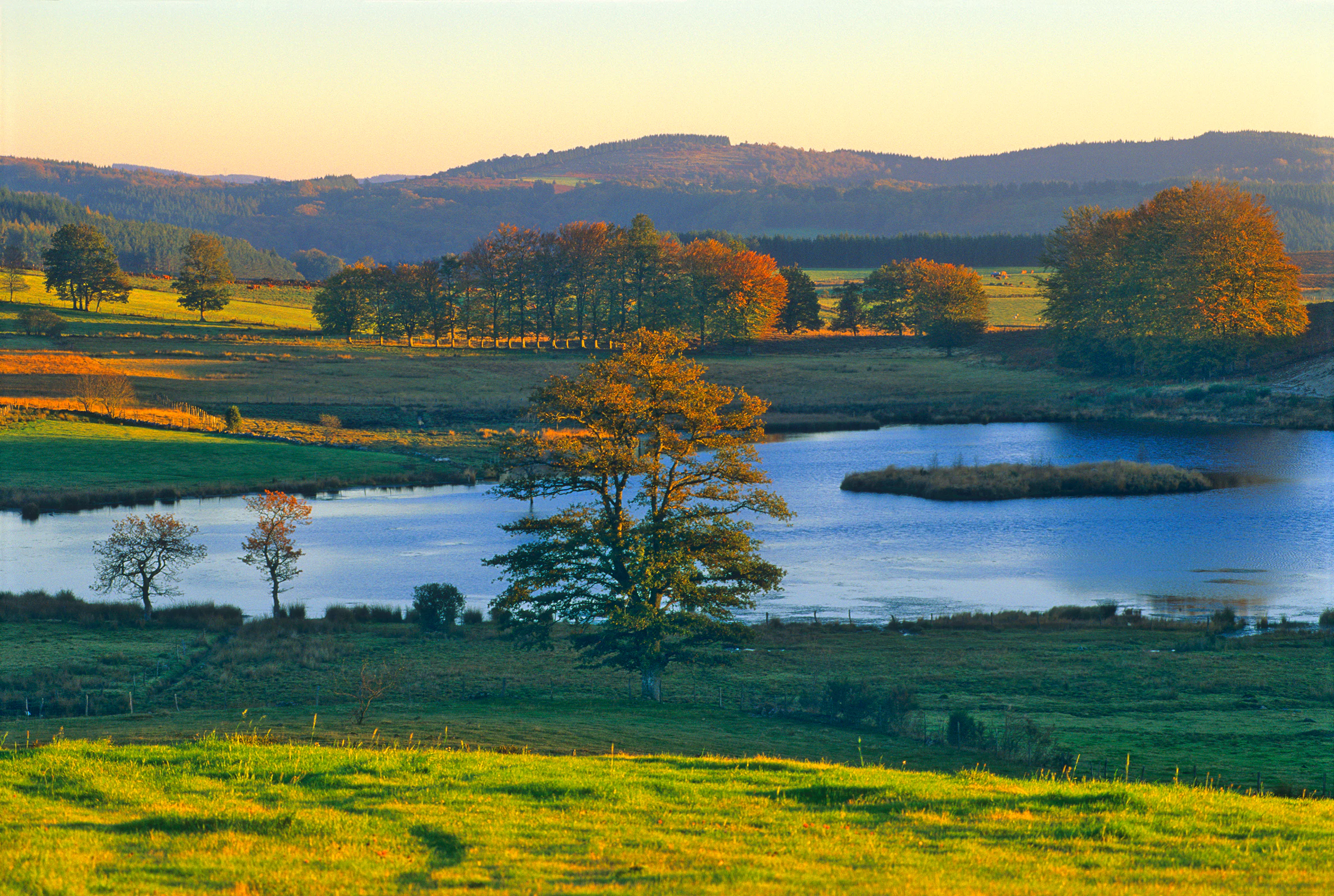
A peaceful landscape view of a small pond surrounded by grassy fields and autumnal trees, with rolling hills in the background under a soft golden sunset sky.
The Chabannes peatland pond at sunset in the Haute Vallée de la Vézère nature reserve.

Regional Natural Reserve of the Upper Vézère Valley history and protected-area timeline

The Regional Natural Reserve of the Upper Vézère Valley was formally created by a deliberation of the Conseil régional on 20 November 2015. Its creation reflects the longstanding work of the Conservatoire d'espaces naturels du Limousin in assembling and managing discrete sites across the upper Vézère basin, eventually bringing them together under a single legal protection framework. Further historical detail is not documented in the available source.

Regional Natural Reserve of the Upper Vézère Valley landscape and geographic character

The reserve occupies a segment of the upper Vézère valley on the Corrèze high country, near the heart of the Plateau de Millevaches. This is rolling, elevated terrain characterized by acidic soils, peat deposits, small ponds, wet meadows, and patches of moorland, with the Vézère and its tributaries cutting shallow valleys through the plateau.

A defining landform is the tourbière-étang de Chabannes near Saint-Merd-les-Oussines, a peatland-pond complex that illustrates how water collects within depressions of the plateau surface to form bogs and shallow pools. The reserve's four separate parcels fragment rather than concentrate this landscape, creating a small-scale mosaic of peatland, wet grassland, and adjacent upland habitats typical of the Massif Central highlands.

Regional Natural Reserve of the Upper Vézère Valley ecosystems, habitats, and plant life

The reserve protects representatives of the peatland and wetland habitats that are characteristic of the upper Vézère basin and the broader Plateau de Millevaches. These habitats include acidic peat bogs, associated shallow étangs, and surrounding wet meadows that depend on consistent hydrological conditions. Such systems support specialized flora and fauna adapted to nutrient-poor, waterlogged environments and are of particular conservation interest in the Limousin region, where they have been reduced in extent by historical drainage and land use change. The reserve's IUCN Category IV status reflects its focus on specific habitat conservation rather than large-scale ecosystem protection.

Regional Natural Reserve of the Upper Vézère Valley wildlife and species highlights

Detailed species information is not documented in the available source material. The reserve can be assumed to support the fauna typical of Limousin peatlands and wet meadows, which generally includes bog-associated invertebrates, amphibians adapted to acidic ponds, and birdlife associated with open wetland and moorland habitats. No specific species list is provided in the source.

Regional Natural Reserve of the Upper Vézère Valley conservation status and protection priorities

The reserve's IUCN Category IV designation reflects a focus on conservation through the protection of particular habitats and species. As a regional nature reserve, it fits into the French system of reserves established at the regional level, providing legal protection on top of any site-level management by the Conservatoire d'espaces naturels du Limousin. Its fragmented, four-parcel structure suggests a strategy of linking small but ecologically important peatland and wetland sites into a single protected framework, supporting the continuity of bog, pond, and wet meadow habitats in the Corrèze highlands. The reserve contributes to wider landscape-scale efforts to maintain the integrity of the upper Vézère basin and the Plateau de Millevaches.

Regional Natural Reserve of the Upper Vézère Valley cultural meaning and human context

The reserve lies in a region historically shaped by traditional upland land use, including pastoral grazing and small-scale peatland management that has long characterized the Plateau de Milveshes and surrounding parts of the Corrèze. The communities of Saint-Merd-les-Oussines and Tarnac are small rural communes whose identities are closely tied to the high valley landscapes the reserve now targets for protection.

Top sights and standout views in Regional Natural Reserve of the Upper Vézère Valley

The reserve's standout features are its peatland-pond systems, most notably the tourbière-étang de Chabannes, and its role as a regional-level legal protection mechanism for fragmented wetland habitats. It is managed by a specialized regional conservatoire and sits within one of the most significant highland wetland regions of the Massif Central.

Best time to visit Regional Natural Reserve of the Upper Vézère Valley

Seasonal guidance is not documented in the available source material. In the Limousin highlands, such peatland and upland landscapes are generally most vividly experienced in late spring and early summer, when wetland vegetation is at its peak, and in autumn, when moisture levels rise and the moorland color palette shifts. Winter conditions on the Plateau de Millevaches can be harsh, with snow and cold temperatures altering both access and scenery.
Monthly climate preview

Long term monthly temperature and precipitation patterns derived from representative coordinates

Réserve naturelle régionale de la haute vallée de la Vézère Climate and Annual Temperature Normals

Representative baseline coordinates record an annual thermal progression spanning from subzero winter minimums to warm summer maximums alongside steady monthly precipitation rates. Analyzing complete monthly climate normals illuminates detailed seasonal variations across this protected upland landscape.
Annual mean10 °C
2 °C19 °C
Jan
Feb
Mar
Apr
May13°
Jun16°
Jul19°
Aug19°
Sep15°
Oct11°
Nov
Dec
Warmest month
August

19.2 °C

Coolest month
January

2.1 °C

Wettest month
November

3.2 mm/day

Driest month
July

2 mm/day

Park location guide

Geography guide, regional context, and park location map for Regional Natural Reserve of the Upper Vézère Valley

Regional Natural Reserve of the Upper Vézère Valley park geography, regions, and map view in France

Understand where Regional Natural Reserve of the Upper Vézère Valley sits in France through a broader geographic reading of the surrounding landscape, nearby location context, and its mapped position within the national park landscape.

How Regional Natural Reserve of the Upper Vézère Valley fits into France

France is a unitary semi-presidential republic and one of the world's largest economies. It borders Belgium, Luxembourg, Germany, Switzerland, Italy, Monaco, Andorra, and Spain, with a maritime border to the United Kingdom. The country is known for its cultural influence, art, cuisine, and political history spanning centuries.

Wider geography shaping Regional Natural Reserve of the Upper Vézère Valley in France

France is located in Western Europe. Metropolitan France extends from the Rhine to the Atlantic Ocean and from the Mediterranean Sea to the English Channel and North Sea. The country borders Belgium, Luxembourg, Germany, Switzerland, Italy, Monaco, Andorra, Spain, and has a maritime border with the United Kingdom.

Map view of Regional Natural Reserve of the Upper Vézère Valley

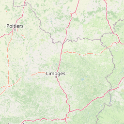
Use this park location map to pinpoint Regional Natural Reserve of the Upper Vézère Valley in France, understand its exact geographic position, and read its mapped placement within the surrounding landscape more clearly.

Pigeon | © OpenStreetMap contributors

Location context for Regional Natural Reserve of the Upper Vézère Valley

Nouvelle-Aquitaine

Explore protected landscape photography, upland terrain views, and peatland habitat character.

Visualizing Réserve naturelle régionale de la haute vallée de la Vézère Photos and Scenery

Visual documentation captures the distinctive wetland habitats, peat bogs, and rolling plateau terrain defining Réserve naturelle régionale de la haute vallée de la Vézère. Examining these protected area photographs reveals the ecological character and upland scenery spanning the upper Vézère basin.

A peaceful landscape view of a small pond surrounded by grassy fields and autumnal trees, with rolling hills in the background under a soft golden sunset sky.

Park atlas

Compare surrounding upland protected areas and regional wetland landscapes

Parks Near Réserve Naturelle Régionale de la Haute Vallée de la Vézère

Visitors can browse other protected areas and wetland reserves located near Réserve naturelle régionale de la haute vallée de la Vézère within the highlands. Extending the geographic comparison reveals broader regional conservation patterns and connected plateau terrain.
A soft watercolor painting of a wide, gently rolling landscape with green fields, forested hills in the distance, and native vegetation in the foreground.
Nature reserveHaute-Vienne
About 48 km away#1 closest

West

Lande de la Flotte et du Cluzeau: Geological Landscapes of Haute-Vienne, France

Nature reserve featuring rare serpentinite heathland habitats

Lande de la Flotte et du Cluzeau preserves a rare type of serpentine heathland on the Limousin plateau. By protecting stony outcrops that contrast with the local forest and farmland, this reserve maintains a significant botanical environment within Haute-Vienne, reflecting the complex metamorphic history of the region.

Area
132 km²
Established
1993
IUCN
IV
A soft watercolor painting of a natural landscape showing rolling green hills, a distant purple mountain range, and a calm body of water reflecting the light, with green foliage on the right bank.
Nature reserveNouvelle-Aquitaine
About 63 km away#2 closest

Northwest

Réserve naturelle régionale des Sauvages: Protected Landscape and Regional Geography

Mapped Habitat Mosaic in the Haute-Vienne of Nouvelle-Aquitaine

Discover the geographic composition of Réserve naturelle régionale des Sauvages, a protected nature reserve in France that integrates diverse habitats including heather-dominated moorland, peatland, beech forest, and historical ponds. This site serves as a key component of the regional conservation landscape within the Haute-Vienne.

Area
0.826 km²
Established
2015
IUCN
IV
Relief
Upland
A soft watercolor painting of a wide, rolling landscape with green hills, pale mountain silhouettes in the background, and a faint reddish-brown foreground, presented on a white background.
Natural monumentAuvergne-Rhône-Alpes
About 65 km away#3 closest

East

Chaîne des Puys - faille de Limagne: Mapping Volcanic and Tectonic Protected Landscapes

Geological exploration of the Auvergne-Rhône-Alpes volcanic chain

Spanning a rhythmic skyline of roughly eighty volcanoes, the Chaîne des Puys - faille de Limagne represents a premier site for studying continental rifting and volcanic landforms. This protected monument offers a clear view into the interplay between the ancient mountain basement, the massive Limagne fault, and the resulting volcanic edifices that define the regional identity of the Auvergne-Rhône-Alpes area.

Area
242.23 km²
Established
2018
Relief
Mountain
Climate
Temperate
Watercolor painting depicting a soft green landscape with rolling hills, riverbank vegetation, and a central waterway.
Nature reserveNouvelle-Aquitaine
About 66 km away#4 closest

South

Réserve naturelle régionale des gorges de la Maronne et Tours de Merle: Protected Gorge Geography

Mapping the Maronne river basin and medieval towers in Nouvelle-Aquitaine

This protected area captures the distinct vertical relief of the Maronne river valley. The landscape profile includes steep rocky outcrops, narrow riparian corridors, and the historic site of the Tours de Merle. Exploring this regional reserve offers an understanding of how northern Massif Central ecosystems and medieval stone structures coexist within a protected framework in the heart of the Corrèze region.

Area
2.059 km²
Established
2025
IUCN
IV
Relief
Upland
Watercolor painting of a soft, hazy mountain landscape with rolling green fields and a distant forest, set against a light, warm, pale background.
Nature reserveAuvergne-Rhône-Alpes
About 80 km away#5 closest

Southeast

Réserve naturelle régionale des tourbières du Jolan et de la Gazelle: Geographic Overview

A vital wetland protected area in the Auvergne volcanic highlands.

Located in the Cantal department, the Réserve naturelle régionale des tourbières du Jolan et de la Gazelle features a unique collection of peatland habitats, trembling mires, and acidic grasslands. This area sits within the broader volcanic terrain of the Parc naturel régional des Volcans d'Auvergne, offering a protected catchment for diverse marshland flora and fauna.

Area
1.558 km²
Established
2018
IUCN
IV
Relief
Highland
Nature reservePuy-de-Dôme
About 80 km away#6 closest

East

Réserve naturelle régionale des cheires et grottes de Volvic: Volcanic Landscapes and Bat Habitats

A regional nature reserve within the Puy-de-Dôme volcanic terrain

This protected area captures the geological signature of the Puy de la Nugère, where trachy-andésite lava flows form a stark surface landscape known as cheires. Beneath these flows, an extensive network of abandoned quarries provides stable cavities for diverse bat species, creating a dual-layered ecological site within the Chaîne des Puys.

Area
0.613 km²
Established
2014
IUCN
IV
Visitors
100K annual
Nature reserveNouvelle-Aquitaine
About 81 km away#7 closest

West

Réserve naturelle régionale du réseau de landes atlantiques du Parc naturel régional Périgord-Limousin

A networked regional nature reserve in Nouvelle-Aquitaine.

This protected area serves as a critical network of Atlantic heathland sites embedded within the larger Périgord-Limousin Regional Natural Park. By conserving these scattered clearings of acidic soil and low vegetation, the reserve maintains a distinct biogeographic feature far from the French coast, offering a clear view into how regional authorities manage fragmented open habitats in the Haute-Vienne.

Area
0.409 km²
Established
2015
IUCN
IV
Scope
Terrestrial
A soft watercolor painting depicting rolling green hills and distant faint mountains under a light sky.
Nature reservePuy-de-Dôme
About 81 km away#8 closest

East

Réserve naturelle nationale du rocher de la Jaquette Protected Area and Volcanic Landscape

Explore rocky cliffs and rare entomological habitats in the Puy-de-Dôme region.

Situated on the flanks of a volcanic outcrop above the Rentières valley, this nature reserve protects a diverse habitat mosaic within the Massif Central. The site provides essential breeding grounds for protected raptors and represents one of the most significant insect sites in central France, offering a clear view into regional volcanic ecology and mountain-valley geography.

Area
0.362 km²
Established
1976
IUCN
IV
Relief
Mountain

Common questions about visiting, size, designation, and location context for Regional Natural Reserve of the Upper Vézère Valley

Regional Natural Reserve of the Upper Vézère Valley FAQs for park facts, access, geography, and protected area context

Find quick answers about Regional Natural Reserve of the Upper Vézère Valley, including protected-area facts, park geography, trail and visitor context, and how the park fits into its surrounding country and regional landscape.
MoriAtlas Explorer

Continue Your Protected Areas Search Across the Global Atlas

Deepen your exploration by continuing the structured search for national parks and protected areas worldwide. Utilize the comprehensive filtering capabilities to compare different conservation landscapes and refine your understanding of global park geography. Discover more about the distribution and characteristics of protected natural areas.

Global natural geography