Mori Atlas logo
Nature reserveRéserve naturelle régionale de Nyer

Examining the altitudinal range, steep gorges, and alpine summit geography of this Pyrenean nature reserve

Réserve naturelle régionale de Nyer: A Protected Mountain Landscape in the Occitanie Region of France

The Réserve naturelle régionale de Nyer encompasses a dramatic vertical expanse in the eastern Pyrenees, stretching from the deep, narrow gorges of the Têt river up to the alpine heights of the Pic de Serra Gallinera. This protected landscape serves as a critical geographic bridge within the Haut-Conflent area, integrating varied terrain that ranges from sun-facing Mediterranean slopes to cool, high-altitude granite plateaus. Through this detailed atlas record, observe the complex ecological mosaic and structural landforms that define this unique French regional nature reserve.

regional nature reservePyreneeseastern PyreneesConflentHaut-ConflentPyrénées-Orientales

Réserve naturelle régionale de Nyer

Nature reserve

Park overview

Structured park overview, official facts, and landscape profile for Réserve naturelle régionale de Nyer

Réserve naturelle régionale de Nyer park facts, protected area profile, and essential visitor context

Review the core facts for Réserve naturelle régionale de Nyer, including designation, size, terrain, visitor scale, habitats, and operating context in one park-focused overview.

About Réserve naturelle régionale de Nyer

The Réserve naturelle régionale de Nyer is a regional nature reserve in the eastern chain of the Pyrenees, located in the Pyrénées-Orientales department within the historical region of Conflent. The protected area covers approximately 2,190 hectares on the right bank of the Têt river, almost entirely on the commune of Nyer, where it accounts for roughly sixty percent of the municipal territory. Its setting places it at the heart of a broader Pyrenean conservation network, bordered by the Réserve naturelle nationale de Py to the north and the Réserve naturelle nationale de Mantet to the south, with all three forming a large, interconnected block of protected mountain landscape in Haut-Conflent.

The reserve is defined above all by its verticality and its physical diversity. The northern entrance is marked by a tight, dramatic gorge, one of the rare geological curiosities of the region, while the elevation rises from the valley floor near 730 meters to the summit of the Pic de Serra Gallinera at about 2,663 meters. Two inverse triangles shape the territory: a northern triangle oriented toward the village of Nyer, and a southern triangle that includes the Mantet valley and the eastern slopes of the Carança valley, meeting at the Pla de l'Orry. The result is a compact reserve that folds together lower Mediterranean slopes, middle-elevation forests, high pastures, cliffs, and alpine zones.

Geologically, the reserve belongs to the Massif de la Carança. Most of the area consists of augen gneiss of the Carança, interrupted by three sub-sectors where alkaline granites intrude. The northern tip of the reserve presents a far more complex geological mosaic, with micaschistes, mylonites, calc-alkaline granites, fine gneisses, calcitic marbles, and dolomites interleaved together. This geological variety reinforces the diversity of soils, exposures, and habitats, giving the reserve an unusually rich ecological character for its area.

Ecologically, the territory under protection is exceptional within the French Pyrenees. Botanical inventories have recorded more than 850 plant species, of which around 80 are considered to have particular protection status or floristic significance. The animal inventory is equally rich, with about 1,365 recorded animal species, including more than 90 bird species, over 500 species of butterflies, amphibians and reptiles characteristic of both mountain and Mediterranean climates, fish such as brown trout in the Mantet river, mammals like the isard, the European wildcat, the pine marten, and the Pyrenean desman, and 14 recorded bat species.

The reserve is also a site of territorial and cultural significance. It was created through a deliberate conservation strategy aimed at preventing speculative pressure on an exceptionally rich mountain property that had been acquired by the local council. Today, it is administered by the Conseil départemental des Pyrénées-Orientales and serves as a place of public education through its on-site visitor center, as well as a vector of local economic activity in a historically underprivileged canton. Its combination of dramatic Pyrenean scenery, deep biodiversity, and strong local engagement makes it one of the emblematic regional nature reserves of the French Pyrenees.

Quick facts and research context for Réserve naturelle régionale de Nyer

The Réserve naturelle régionale de Nyer is a French regional nature reserve covering about 2,190 hectares in the eastern Pyrenees. It lies in the Pyrénées-Orientales department, in the Haut-Conflent area, on the right bank of the Têt river, on the commune of Nyer. The reserve stretches from approximately 730 meters up to about 2,660 meters at the Pic de Serra Gallinera, making it a true vertical mountain reserve dominated by deep gorges, forests, and high alpine terrain.

It was first protected as a voluntary nature reserve in 1998, then reclassified as a regional nature reserve in 2007, and is managed by the Conseil départemental des Pyrénées-Orientales. Classified as an IUCN Category IV area, it works in concert with the neighboring reserves of Py and Mantet to protect one of the most ecologically rich sections of the French Pyrenees.

Protection and recognition

Terrestrial conservation framework and official designation metrics for regional protected lands.

Réserve naturelle régionale de Nyer Protection Status and Mapped Designation History

Protected area records for Réserve naturelle régionale de Nyer outline terrestrial conservation status established in 2007. Documented management scope and international recognition metrics provide essential baseline data for this regional landscape.

Protection details

Protection scope
Terrestrial
Designated year
2007
Transboundary protection
No
WDPA ID
555514318
Park context

Deeper park guide and search-rich context for Réserve naturelle régionale de Nyer

Réserve naturelle régionale de Nyer history, landscape, wildlife, and travel context

Explore Réserve naturelle régionale de Nyer through its history, landscape character, ecosystems, wildlife, conservation priorities, cultural context, and seasonal travel timing in a structured park guide built for atlas discovery and search intent.

Why Réserve naturelle régionale de Nyer stands out

The Nyer reserve is especially known for its spectacular narrow gorges and exceptional altitudinal range, which together create a striking transition from Mediterranean-influenced lower slopes to true alpine environments at the Pic de Serra Gallinera. This vertical zonation supports a remarkable mix of habitats in a relatively compact area, from rocky cliffs and chestnut forests up to mountain pastures and high granite plateaus. Equally distinctive is the reserve's biodiversity profile at the meeting point of Mediterranean and mountain climates. It shelters a wide range of species, including golden eagles, blue rock thrushes, isards (Pyrenean chamois), wildcats, Pyrenean desmans, and the Apollo butterfly. The combination of dramatic geology, varied habitats, and rich fauna makes Nyer a textbook example of a Pyrenean mountain reserve where landscape, geology, and wildlife converge.

Réserve naturelle régionale de Nyer history and protected-area timeline

The history of the Nyer reserve begins with a deliberate public acquisition strategy. In October 1995, the Conseil général des Pyrénées-Orientales acquired a 2,265-hectare property on the commune of Nyer, with financial support from the European Union and the French state, to prevent speculative development on a site of very high natural value. To secure long-term protection, the council opted in 1996 for the creation of a voluntary nature reserve (Réserve naturelle volontaire), beginning with a scientific inventory carried out by the Charles Flahault association in 1996, which highlighted the area's landscape value, biodiversity, the predominance of forest habitats, and rich cultural heritage.

Following this preparatory work, the Préfecture des Pyrénées-Orientales approved the creation of the Réserve naturelle volontaire de Nyer on 21 January 1998 via prefectoral order number 178/98, giving the property formal protection under the voluntary reserve system of the time. After France's 2002 law on proximity democracy reformed the protected area framework, all voluntary nature reserves were declassified, requiring a reclassification process. In response, the Conseil régional de Languedoc-Roussillon adopted deliberation number 07/15.256 on 18 October 2007, formally creating the Réserve naturelle régionale de Nyer, valid for ten years and renewable under the Environment Code.

Since 1998, the Conseil général (now Conseil départemental) des Pyrénées-Orientales has remained both landowner and manager of the site, and continues to manage it today through a delegated management agreement. The reserve is administered under IUCN Category IV criteria, with a regulated framework built jointly with local users, including hunters, livestock farmers, and the commune of Nyer, balancing habitat protection, scientific monitoring, and public outreach.

Réserve naturelle régionale de Nyer landscape and geographic character

The landscape of the Nyer reserve is defined by an exceptional altitudinal range compressed into a single protected block. The territory begins in the north with a dramatic gorge, one of the rare such landforms in the eastern Pyrenees, opening onto the right bank of the Têt river and the commune of Nyer. From an entrance near 730 meters elevation, the land climbs steeply through forested middle slopes, eventually reaching the Pic de Serra Gallinera at about 2,663 meters and the high-altitude plateau of Serra Gallinera, one of the reserve's distinctive geomorphological features.

The reserve is naturally split into two inverse triangles that meet at the Planell de l'Orry. The northern triangle points toward the village of Nyer and is marked by the narrow gorges that introduce the protected area. The southern triangle extends toward the Mantet valley and the eastern side of the Carança valley, dominated by the massif of Serra Gallinera and a sequence of cliffs, slopes, and upper cirques. Throughout the reserve, exposures alternate between warm, sun-facing Mediterranean slopes and cooler north-facing mountain flanks, generating striking contrasts in vegetation, soil, and climate at very short distances.

The geological substrate of mostly Carança augen gneiss, interrupted by alkaline granite intrusions and a complex mix of metamorphic rocks in the north, produces varied terrain with sharp cliffs, rocky outcrops, deep valleys, and high ledges. Together, these landforms give the reserve its strongly vertical, three-dimensional character: a Pyrenean landscape where steep gorges give way to open forest, and where the terrain finally opens into the bare rock and alpine pastures typical of the high Pyrenees.

Réserve naturelle régionale de Nyer ecosystems, habitats, and plant life

The nature of the Nyer reserve reflects the meeting point of Mediterranean and mountain climates, producing a remarkable diversity of habitats within a relatively small surface area. The altitudinal gradient from around 730 meters to over 2,600 meters compresses into a single territory a succession that elsewhere spreads across many kilometers: thermophilic lower slopes, montane forests, subalpine formations, alpine heaths, cliffs, and rocky plateaus. This habitat zonation is amplified by the alternation of warm and cold exposures along steep relief and by contrasting geological substrates.

Forests are a central element of the reserve's ecological identity, reflecting the historic dominance of woodland in the area. As elevation rises, vegetation shifts through different stages, giving way above the treeline to open rocky environments and high pastures still shaped by traditional pastoralism, a practice that the management plan explicitly tries to maintain because of its close link to habitat diversity. The mosaic of cliffs, gorges, slopes, and plateaus creates highly varied microhabitats, from shaded wet rock faces to sun-baked limestone and dolomite outcrops in the north of the reserve.

Overall, the Nyer reserve stands out ecologically for the unusually high concentration of different habitat types and the way Mediterranean, montane, and alpine influences overlap on the same slopes. With more than 850 recorded plant species, including about 80 of particular conservation interest, the territory offers an unusually dense botanical richness for a regional reserve of this size, and provides the foundation for the equally diverse fauna recorded across the site.

Réserve naturelle régionale de Nyer wildlife and species highlights

The wildlife of the Nyer reserve is exceptionally rich given its surface area, with about 1,365 animal species recorded to date. The territory supports a particularly well-documented butterfly fauna, with more than 500 species of Lepidoptera inventoried, including the Apollo butterfly, a protected emblem of mountain environments, along with species such as the Proserpine and the large blue of the thyme. Dragonflies are also present in ten recorded species, reflecting the site's value for freshwater invertebrates wherever suitable water bodies exist.

Fish fauna is concentrated in the Mantet river, the local name for the watercourse running through the reserve, where brown trout maintain populations despite the difficult access of the riverbed. Reptiles and amphibians have been inventoried since 2001, with eight reptile and three amphibian species currently documented, including both Mediterranean species such as the eyed lizard and montane species such as the common frog and the fire salamander, whose females return each year to tributaries of the Mantet and Carança rivers to give birth. Eleven mollusk species have also been recorded.

Birds are among the most visible elements of the reserve's wildlife, with 93 species documented. The cliffs and gorges favor large raptors such as the golden eagle, while open rock and scrub habitats host passerines including the blue rock thrush and the wood lark. Among mammals, the isard, the emblematic Pyrenean chamois, shares the reserve with species such as the European wildcat, the pine marten, the genet, the Pyrenean desman, the marmot, and 14 bat species. All bat species in France are legally protected, and their monitoring since 2002 has become an important component of the reserve's conservation work.

Réserve naturelle régionale de Nyer conservation status and protection priorities

The conservation significance of the Nyer reserve lies in its protection of a remarkably dense and diverse Pyrenean ecosystem within a single, well-defined territory. By safeguarding nearly sixty percent of the commune of Nyer, the reserve protects a continuum of habitats, from Mediterranean lowland forests up to alpine summits, that would otherwise be exposed to fragmentation, land-use change, or speculative pressure. Its classification as an IUCN Category IV protected area reflects its primary purpose: the management of habitats and species of high conservation value.

The reserve's regulations were developed jointly with the local users of the site, including hunters, livestock farmers, and the commune of Nyer, with the aim of consolidating habitat protection while preserving traditional activities such as pastoralism. Active management includes scientific monitoring of species and habitats on an ongoing basis, to ensure that decisions on intervention or non-intervention are grounded in current ecological knowledge. Specific concerns include the limited availability of water points on the site, which restricts the presence of certain amphibians and the conditions for pastoralism; restoration or rehabilitation of such water points is identified as a priority in the management approach.

Beyond direct habitat protection, the reserve contributes to a broader network of protected areas in the eastern Pyrenees, adjoining the national nature reserves of Py and Mantet to form a large, continuous block of conserved mountain landscape. This network-level role, combined with its function as a refuge for sensitive species such as the Pyrenean desman, the Apollo butterfly, golden eagles, and the full range of French bat species, gives the Nyer reserve an outsized conservation importance at the regional scale of the French Pyrenees.

Réserve naturelle régionale de Nyer cultural meaning and human context

The Nyer reserve sits in Haut-Conflent, a historical Pyrenean region of the Pyrénées-Orientales with a strong Catalan cultural identity. Its mountains have long supported traditional mountain economies combining forestry, small-scale agriculture, and seasonal pastoralism, all of which have shaped the present-day landscapes of forests and open pastures. The reserve's management framework explicitly recognizes this heritage by integrating local stakeholders such as hunters, farmers, and the commune into the regulatory process.

The pre-protection cultural inventory carried out by the Charles Flahault association in 1996 highlighted not only the ecological richness of the property but also the cultural richness of the territory, including its built heritage, agricultural patterns, and traditional land uses. Today, the reserve plays an active role in local identity and rural development, providing employment, visitor activity, and educational resources in a historically disadvantaged mountain canton. The maison de la Réserve, accessible to visitors with disabilities and used by school groups, has become a center for both nature awareness and the transmission of regional mountain heritage.

Top sights and standout views in Réserve naturelle régionale de Nyer

What sets the Nyer reserve apart is the combination, within a single protected area, of dramatic vertical relief, a continuous habitat gradient from Mediterranean slopes to high alpine zones, and an exceptionally rich fauna and flora. The northern entry gorges are among the most striking geological features of the eastern Pyrenees, while the Pic de Serra Gallinera and its surrounding plateau dominate the southern half of the reserve.

Ecologically, the reserve functions as a key link between the national nature reserves of Py and Mantet, extending protection across a major block of the eastern Pyrenees. Botanically, more than 850 plant species are recorded; zoologically, about 1,365 animal species, including more than 90 bird species and more than 500 species of butterflies, give the reserve a scientific importance well beyond its modest size. Visually, scenically, and ecologically, Nyer offers one of the most concentrated examples of Pyrenean mountain nature accessible through a regional nature reserve in France.

Best time to visit Réserve naturelle régionale de Nyer

The Nyer reserve spans a wide altitudinal range, so the best time to visit depends strongly on what kind of landscape a visitor wants to experience. Late spring and early summer, from roughly May to early July, are usually the most rewarding periods for visitors interested in wildflowers, butterflies such as the Apollo, and the fresh green landscapes of forests and alpine meadows, before the high summer heat in the lower gorges.

Monthly climate preview

Long-term monthly temperature averages and precipitation patterns sampled from representative park terrain

Annual Climate Normals and Temperature Rhythms for Réserve naturelle régionale de Nyer

Representative point measurements reveal long-term average monthly temperatures spanning sub-zero winter minimums to warm summer highs alongside recorded daily precipitation rates. Examining the full twelve-month profile provides complete historical climate data and detailed monthly meteorological baselines.
Annual mean11 °C
3 °C20 °C
Jan
Feb
Mar
Apr
May13°
Jun18°
Jul20°
Aug20°
Sep16°
Oct12°
Nov
Dec
Warmest month
July

20.4 °C

Coolest month
January

2.8 °C

Wettest month
October

2.3 mm/day

Driest month
July

1 mm/day

Park location guide

Geography guide, regional context, and park location map for Réserve naturelle régionale de Nyer

Réserve naturelle régionale de Nyer park geography, regions, and map view in France

Understand where Réserve naturelle régionale de Nyer sits in France through a broader geographic reading of the surrounding landscape, nearby location context, and its mapped position within the national park landscape.

How Réserve naturelle régionale de Nyer fits into France

France is a unitary semi-presidential republic and one of the world's largest economies. It borders Belgium, Luxembourg, Germany, Switzerland, Italy, Monaco, Andorra, and Spain, with a maritime border to the United Kingdom. The country is known for its cultural influence, art, cuisine, and political history spanning centuries.

Wider geography shaping Réserve naturelle régionale de Nyer in France

France is located in Western Europe. Metropolitan France extends from the Rhine to the Atlantic Ocean and from the Mediterranean Sea to the English Channel and North Sea. The country borders Belgium, Luxembourg, Germany, Switzerland, Italy, Monaco, Andorra, Spain, and has a maritime border with the United Kingdom.

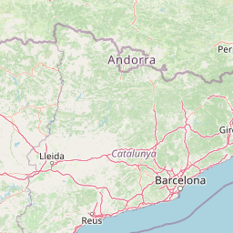
Map view of Réserve naturelle régionale de Nyer

Use this park location map to pinpoint Réserve naturelle régionale de Nyer in France, understand its exact geographic position, and read its mapped placement within the surrounding landscape more clearly.

Pigeon | © OpenStreetMap contributors

Location context for Réserve naturelle régionale de Nyer

Occitanie
Park atlas

Compare adjacent mountain landscapes and connected protected areas across the eastern Pyrenees.

Parks Near Réserve Naturelle Régionale de Nyer and Surrounding Pyrenean Reserves

Browsing other protected areas near Réserve naturelle régionale de Nyer reveals a continuous network of mountain reserves sharing similar alpine terrain. Expanding the geographic comparison highlights broader regional conservation patterns and connected geological corridors.
Nature reserveOccitanie
About 34 km away#1 closest

Northwest

Réserve naturelle nationale de la Grotte du T.M. 71: Geological Protected Area Map

Subterranean karst exploration in the Aude department of Occitanie

Located in the foothills bordering the Pyrenees, the Réserve naturelle nationale de la Grotte du T.M. 71 protects a sprawling network of limestone passages. This site represents a key protected area for the study of subterranean mineral formations and Pyrenean karst evolution, featuring kilometres of mapped galleries maintained under a strict integral conservation framework.

Area
0.96 km²
Established
1987
IUCN
III
Protected areaAndorra
About 50 km away#2 closest

West

Madriu-Perafita-Claror Valley: Geographic Overview of Andorra's Premier Protected Landscape

An examination of glacial landforms and historic mountain heritage.

Spanning nine percent of Andorra, the Madriu-Perafita-Claror Valley remains a rare example of a preserved Pyrenean cultural landscape. This protected area features granite cliffs, glacial cirques, and historic ironworking remnants, offering a deep look into the environmental legacy of mountain societies within a remote, foot-access-only basin.

Area
42.47 km²
Established
2004
Relief
Mountain
Climate
Alpine
Watercolor painting of a tranquil natural landscape with a stream flowing through grassy hills, wildflowers, and a backdrop of distant purple-toned mountains.
Nature reserveOccitanie
About 61 km away#3 closest

East

Réserve naturelle nationale de la forêt de la Massane: Geographic and Protected Area Map

Ancient beech forest terrain in the Occitanie mountain landscape

Situated in the upper valley of the Massane river, this protected reserve provides a rare glimpse into ancient forest evolution. With its dense concentration of documented species and unique geological base, it stands as a reference point for studying climate change impacts on Mediterranean mountain terrain and protected woodland architecture.

Area
3.4 km²
Established
1973
IUCN
IV
Visitors
40K annual
Watercolor painting of a river winding through a valley with green fields, trees, and distant hills
Protected areaAndorra
About 65 km away#4 closest

West

Parc Natural Comunal de les Valls del Comapedrosa: Andorra's Highest Protected Alpine Landscape

Explore the Pyrenean terrain and mapped boundaries of Andorra's summit park.

Parc Natural Comunal de les Valls del Comapedrosa is the primary high-altitude protected area in Andorra, defined by its rugged alpine terrain and the presence of Coma Pedrosa, the country's highest peak. This protected landscape offers a significant geographic anchor for exploring the Pyrenees, highlighting the unique mountain conservation efforts. Its mapped boundaries encompass dramatic valleys and steep ridges, providing a clear context for understanding Andorra's mountainous geography through a structured atlas lens.

Area
15.43 km²
Established
2003
IUCN
IV
Relief
Mountain
Watercolor painting depicting a landscape with marshy green foreground, winding water, distant trees, and mountains under a light sky.
Nature reserveOccitanie
About 88 km away#5 closest

Northeast

Réserve naturelle régionale de Sainte-Lucie: Protected Coastal Geography in Occitanie

Coastal lagoons, island habitats, and Mediterranean marshlands.

This protected area profile explores the physical geography of Réserve naturelle régionale de Sainte-Lucie. Understand the interplay between the central island landform, brackish lagoon networks, and the Mediterranean beach ecosystems that define this unique French conservation landscape.

Area
8.25 km²
Established
2009
IUCN
IV
Relief
Lowland
Watercolor illustration of a mountainous landscape with a river, green vegetation, and distant peaks under a light sky
National parkProvince of Lleida
About 100 km away#6 closest

West

Aigüestortes i Estany de Sant Maurici National Park: Pyrenean High Mountain National Park Landscape

Explore glacial lakes and winding waterways in Catalonia.

Aigüestortes i Estany de Sant Maurici National Park is a premier national park in the Pyrenees, celebrated for its extensive network of almost 200 glacial lakes and the dramatic natural beauty of the Sant Maurici lake. Its landscape is defined by high mountain terrain, characterized by U-shaped valleys, sharp ridges, and unique hydrological features like the Aigüestortes plain's meandering streams. This protected area in the Province of Lleida offers a rich setting for understanding alpine environments and Pyrenean geography through detailed mapping and atlas exploration.

Area
141 km²
Established
1955
IUCN
II
Visitors
525K annual
Nature reserveOccitanie
About 122 km away#7 closest

North

Réserve naturelle régionale de Cambounet-sur-le-Sor: Protected Wetland Geography

Alluvial floodplain habitat in the Tarn, Occitanie

Situated in the Tarn department of Occitanie, this nature reserve guards a dense wetland habitat shaped by the confluence of the Sor and Agout rivers. The area stands as an ecological centerpiece, providing sheltered riparian woodland and marshy terrain for more than one hundred and seventy recorded bird species, making it a distinct study in French riverine conservation.

Area
0.309 km²
Established
1990
IUCN
IV
Relief
Lowland
A wide, soft-focus watercolor painting showing a winding river through a lush green valley with rolling hills in the background.
Nature reserveOccitanie
About 134 km away#8 closest

Northwest

Réserve naturelle régionale Confluence Garonne-Ariège: Protected Riverine Geography and Mapping

A significant riparian landscape in the Occitanie region

Discover the protected river corridors and diverse natural terrain of the Réserve naturelle régionale Confluence Garonne-Ariège. This regional nature reserve marks the confluence of the Garonne and Ariège rivers, showcasing a complex mosaic of alluvial forest, riparian wetlands, and dry hillside woodlands that characterize the geography south of Toulouse.

Area
5.791 km²
Established
2015
IUCN
IV
Relief
Mixed relief

Common questions about visiting, size, designation, and location context for Réserve naturelle régionale de Nyer

Réserve naturelle régionale de Nyer FAQs for park facts, access, geography, and protected area context

Find quick answers about Réserve naturelle régionale de Nyer, including protected-area facts, park geography, trail and visitor context, and how the park fits into its surrounding country and regional landscape.
MoriAtlas Explorer

Continue Your Protected Areas Search Across the Global Atlas

Deepen your exploration by continuing the structured search for national parks and protected areas worldwide. Utilize the comprehensive filtering capabilities to compare different conservation landscapes and refine your understanding of global park geography. Discover more about the distribution and characteristics of protected natural areas.

Global natural geography