Mori Atlas logo
Nature reserveRéserve naturelle régionale de Saint-Maurin

A specialized regional nature reserve within the Verdon gorge featuring distinct tufa geological formations

Réserve naturelle régionale de Saint-Maurin: Mapped Travertine Landscapes and Gorge Geography

The Réserve naturelle régionale de Saint-Maurin is a protected area located at the western entrance of the Gorges du Verdon in southeastern France. This reserve is defined by its unusual travertine formations and mineral-rich springs that have sculpted limestone cliff faces over time. The site preserves a concentrated habitat for bat colonies and diverse bryophyte flora within its compact territorial boundaries in the Provence-Alpes-Côte d'Azur region.

regional nature reservetravertine formationstufa cavesgorge landscapeVerdonProvence-Alpes-Côte d'Azur

Réserve naturelle régionale de Saint-Maurin

Nature reserve

Park overview

Structured park overview, official facts, and landscape profile for Réserve naturelle régionale de Saint-Maurin

Réserve naturelle régionale de Saint-Maurin park facts, protected area profile, and essential visitor context

Review the core facts for Réserve naturelle régionale de Saint-Maurin, including designation, size, terrain, visitor scale, habitats, and operating context in one park-focused overview.

About Réserve naturelle régionale de Saint-Maurin

The Réserve naturelle régionale de Saint-Maurin is a compact yet highly focused protected area that preserves a very specific combination of geology, caves, and Mediterranean gorge habitat at the western threshold of the Verdon canyon. Although the reserve covers only around 25 hectares, its value lies in the rarity of what it protects rather than its scale.

The defining feature of Saint-Maurin is its travertine landscape. As waters from various springs flow through limestone bedrock, they release calcium carbonate that precipitates and slowly builds up the porous, sculpted tufa formations the reserve is named for. These formations are not only scenic but ecologically important, because the constantly moist, mineral-rich surfaces support specialist plant and bryophyte communities found in few other places in the region.

Carved into these same tufa deposits are the Saint-Maurin caves, which carry a long human history as well as natural history. Nearby communities have used the cavities for centuries, mainly for religious purposes, and the reserve today helps reconcile heritage, geology, and biodiversity in a single protected perimeter.

Administratively, the reserve sits within the Verdon Regional Natural Park and benefits from three-way governance involving the local commune of La Palud-sur-Verdon, the regional Conservatoire d'espaces naturels, and the park authority itself. Its management reflects the increasing importance in France of small, locally anchored nature reserves designed around precise natural heritage targets.

Quick facts and research context for Réserve naturelle régionale de Saint-Maurin

The Réserve naturelle régionale de Saint-Maurin is a French regional nature reserve (réserve naturelle régionale) created by deliberation on 30 October 2009. It lies in the commune of La Palud-sur-Verdon, in the Alpes-de-Haute-Provence department, within the Provence-Alpes-Côte d'Azur region.

It is classified as an IUCN Category IV protected area and falls inside the larger Parc naturel régional du Verdon. The reserve covers about 25 hectares and is managed jointly by the commune of La Palud-sur-Verdon, the Conservatoire d'espaces naturels de Provence-Alpes-Côte d'Azur, and the Verdon Regional Natural Park.

Protection and recognition

Documented terrestrial protection scope and international recognition records

Réserve naturelle régionale de Saint-Maurin Protection Status and Recognition

Terrestrial protection status records for Réserve naturelle régionale de Saint-Maurin outline the established management scope and administrative designation details. Reference data tracks official conservation frameworks, protected area boundaries, and international recognition sources without assuming active management outcomes.

Protection details

Protection scope
Terrestrial
Transboundary protection
No
WDPA ID
555514402
Park context

Deeper park guide and search-rich context for Réserve naturelle régionale de Saint-Maurin

Réserve naturelle régionale de Saint-Maurin history, landscape, wildlife, and travel context

Explore Réserve naturelle régionale de Saint-Maurin through its history, landscape character, ecosystems, wildlife, conservation priorities, cultural context, and seasonal travel timing in a structured park guide built for atlas discovery and search intent.

Why Réserve naturelle régionale de Saint-Maurin stands out

Saint-Maurin is best known for its travertine formations, mineral deposits built up over time as calcium carbonate-rich spring waters precipitate along the lower reaches of the Gorges du Verdon. Within these tufa masses sit the Saint-Maurin caves, a small but geologically distinctive cavity system. Beyond geology, the reserve is recognized for hosting a remarkable concentration of bat species in a very small area, greeting visiting birdlife such as the griffon vulture near the gorge entrance, and supporting a rich bryophyte and vascular flora shaped by the variety of microhabitats across slopes, springs, and cliff faces.
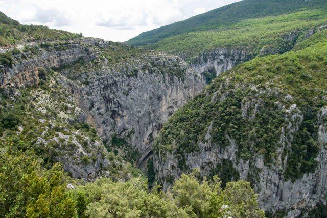
A wide, high-angle view looking down into a deep river gorge with sheer limestone cliffs covered in green Mediterranean scrub vegetation.
A view overlooking the deep, limestone-walled gorge of the Verdon River near La Palud-sur-Verdon.

Réserve naturelle régionale de Saint-Maurin history and protected-area timeline

The reserve follows a long period in which the Saint-Maurin caves and their travertine surroundings held cultural significance. For a considerable time, the cave site was used by religious communities, embedding the location into local heritage as much as natural history.

Modern recognition of its ecological and geological value culminated in the formal creation of the Réserve naturelle régionale de Saint-Maurin on 30 October 2009. The decision brought the travertine formations, springs, and caves under a dedicated protection regime that places the site within the broader framework of the Parc naturel régional du Verdon. By handing management to the commune of La Palud-sur-Verdon alongside the regional nature conservancy and the Verdon park, the reserve reflects a governance model built on local anchoring and regional partnership.

Réserve naturelle régionale de Saint-Maurin landscape and geographic character

The reserve occupies a narrow but visually dramatic strip of terrain at the mouth of the Gorges du Verdon, where the canyon begins to tighten and the limestone walls close in around the waters of the Verdon. This is classic Provençal gorge country, defined by steep cliffs, sheltered ledges, and a marked contrast between sun-baked rock faces and perpetually moist zones near springs.

The most distinctive element of the landscape is the travertine. Instead of the bare white limestone for which the Verdon is best known, Saint-Maurin offers a softer, more sculpted topography of tufa terraces, cascades, and rimstone-like surfaces built mineral by mineral as spring water emerges and cools. These formations create a constantly shifting microtopography of basins, ledges, and porous outcrops.

Below the tufa, the Saint-Maurin caves open as hollow chambers and passages shaped in the same deposits, adding an underground dimension to the visible landscape. The surrounding slopes, road corridors, and the old GR4 long-distance trail give visitors a way to read this landscape at multiple scales, from the gorge itself to the smallest travertine cascade.

Réserve naturelle régionale de Saint-Maurin ecosystems, habitats, and plant life

The ecological character of Saint-Maurin is shaped by the interplay of travertine, springs, caves, cliffs, and surrounding Mediterranean vegetation. The constantly wet mineral surfaces create habitats very different from the dry garrigue and woodland that dominate the Verdon region, and the steep topography creates a wide range of exposures, from full sun to deep shade.

The diversity of these microhabitats supports a particularly rich flora and bryophyte community for so small a site. Moist tufa surfaces host specialist mosses and liverworts, while warmer rock faces and ledges carry more typical upland Mediterranean plant species. This combination of dry cliff habitats and permanently humid travertine is what makes the reserve an unusually rewarding place for botanists.

The mosaic of cliff, woodland, water, and cave also extends what the reserve offers ecologically. The transition between canyon mouth and limestone plateau means the reserve functions almost like an ecological frontier, combining species characteristic of the gorge interior with those of the broader Provençal countryside.

Réserve naturelle régionale de Saint-Maurin wildlife and species highlights

Although the reserve is small, it harbors a distinctive wildlife profile linked to its cliffs, caves, and travertine habitats. The open sky above the gorge entrance is used by soaring birds, including the griffon vulture, one of the most emblematic species of the Verdon region. Visitors with patience can often observe these large raptors riding thermals along the cliff faces near the reserve.

The caves and travertine cavities shelter a particularly notable bat fauna. Several species are reported around the site, including lesser horseshoe bats, notch-eared bats, mountain long-eared bats, and European free-tailed bats. The combination of roosting cavities, proximity to water, and insect-rich habitats makes the reserve especially valuable for chiropterans relative to its size.

Beyond these headline species, the reserve supports the broader invertebrate and small vertebrate life typical of the lower Verdon, with cave-dwelling fauna, spring-associated insects, and reptiles adapted to the warm rocky terrain all contributing to the site-level biodiversity.

Réserve naturelle régionale de Saint-Maurin conservation status and protection priorities

The conservation significance of Saint-Maurin lies above all in the protection of its travertine formations, a relatively rare habitat type in France and a high-priority target for habitat conservation. Because tufa deposits are built up over long periods through a delicate hydrological and chemical balance, they are vulnerable to changes in water quality and flow, making formal protection especially important.

Its IUCN Category IV designation as a regional nature reserve reflects this targeted approach. Rather than protecting a large expanse of general landscape, the reserve conserves a specific natural heritage feature, the travertine-cavity complex, along with the species communities that depend on it.

The reserve also strengthens the conservation network of the Parc naturel régional du Verdon. By integrating Saint-Maurin into a broader protected-mosaic strategy, regional managers ensure that the very specific geological and ecological values of the site complement, rather than duplicate, the work being done across the wider Verdon territory.

Réserve naturelle régionale de Saint-Maurin cultural meaning and human context

The reserve's cultural context is rooted in the Saint-Maurin caves themselves. These cavities, formed in the travertine that the reserve protects, were used by religious communities over an extended period, giving the site a heritage dimension beyond its natural value.

As part of the commune of La Palud-sur-Verdon and the broader Verdon region, Saint-Maurin also sits within a landscape shaped by traditional Provençal life: hill villages perched above the gorge, terraced agriculture on the plateau, and a long history of pastoral and rural land use. The reserve today functions as a small but meaningful place where this human and religious history meets the geological story of the gorge.

Top sights and standout views in Réserve naturelle régionale de Saint-Maurin

Saint-Maurin's standout quality is its travertine landscape, a sculpted tufa terrain whose rarity and ecological richness punch well above the reserve's modest size. The integration of these formations with the Saint-Maurin caves, where geology and centuries-old human use intersect, gives the site an unusually layered character.

Equally notable is the reserve's wildlife profile, particularly its bat community and the presence of griffon vulture, alongside a bryophyte and plant richness driven by the diversity of microhabitats within a few hectares.

Best time to visit Réserve naturelle régionale de Saint-Maurin

Spring and early summer are particularly rewarding for Saint-Maurin, when spring flows are typically at their most active, giving the travertine formations their freshest, wettest appearance and supporting the richest bryophyte and plant growth. This is also a good period for general botanical interest and bat cave visits.

Late spring through early autumn also offers good conditions for observing vultures and other soaring birds along the gorge, with stable weather and warm cliff faces favoring raptor activity. Winter visits are possible and quieter but coincide with lower water flow and reduced vegetation, making the travertine formations and caves the main focus rather than the broader biological richness.

Monthly climate preview

Long-term temperature ranges and monthly precipitation patterns derived from representative terrain coordinates.

Réserve naturelle régionale de Saint-Maurin Climate Normals and Annual Weather Rhythm

Recorded monthly climate data for Réserve naturelle régionale de Saint-Maurin tracks measured shifts in average daily temperatures and precipitation rates across a representative elevation point. Reviewing the complete twelve-month profile provides deeper analytical context for long-term meteorological normals across the protected landscape.
Annual mean10 °C
1 °C21 °C
Jan
Feb
Mar
Apr
May13°
Jun18°
Jul21°
Aug21°
Sep16°
Oct11°
Nov
Dec
Warmest month
July

21 °C

Coolest month
January

1.2 °C

Wettest month
November

3.2 mm/day

Driest month
July

0.8 mm/day

Park location guide

Geography guide, regional context, and park location map for Réserve naturelle régionale de Saint-Maurin

Réserve naturelle régionale de Saint-Maurin park geography, regions, and map view in France

Understand where Réserve naturelle régionale de Saint-Maurin sits in France through a broader geographic reading of the surrounding landscape, nearby location context, and its mapped position within the national park landscape.

How Réserve naturelle régionale de Saint-Maurin fits into France

France is a unitary semi-presidential republic and one of the world's largest economies. It borders Belgium, Luxembourg, Germany, Switzerland, Italy, Monaco, Andorra, and Spain, with a maritime border to the United Kingdom. The country is known for its cultural influence, art, cuisine, and political history spanning centuries.

Wider geography shaping Réserve naturelle régionale de Saint-Maurin in France

France is located in Western Europe. Metropolitan France extends from the Rhine to the Atlantic Ocean and from the Mediterranean Sea to the English Channel and North Sea. The country borders Belgium, Luxembourg, Germany, Switzerland, Italy, Monaco, Andorra, Spain, and has a maritime border with the United Kingdom.

Map view of Réserve naturelle régionale de Saint-Maurin

Use this park location map to pinpoint Réserve naturelle régionale de Saint-Maurin in France, understand its exact geographic position, and read its mapped placement within the surrounding landscape more clearly.

Pigeon | © OpenStreetMap contributors

Location context for Réserve naturelle régionale de Saint-Maurin

Provence-Alpes-Côte d'Azur

Visualizing travertine formations, limestone cliffs, and protected gorge habitats

Réserve naturelle régionale de Saint-Maurin Photos and Landscape Scenery

Visual documentation reveals the striking topography of travertine terraces, tufa cascades, and sheltered cave entrances defining the protected reserve. Examining these detailed landscape photographs provides clear insight into the rare mineral formations and microhabitats characterizing the canyon environment.

A wide, high-angle view looking down into a deep river gorge with sheer limestone cliffs covered in green Mediterranean scrub vegetation.

Park atlas

Compare surrounding gorge landscapes and regional natural reserves in southeastern France.

Explore Protected Areas and Parks Near Réserve naturelle régionale de Saint-Maurin

Browse protected areas and regional parks located near Réserve naturelle régionale de Saint-Maurin to continue your geographic comparison of the surrounding limestone terrain. Discover adjacent conservation landscapes and similar protected habitats across the wider Provençal region.
A soft watercolor painting of a rolling hilly landscape with muted greens, yellows, and purples on a white background.
Nature reserveProvence-Alpes-Côte d'Azur
About 31 km away#1 closest

North

Réserve naturelle géologique de Haute-Provence: Geological Protected Area and Map Atlas

Tracing fossil-rich outcrops across the French Pre-Alps regional landscape

Spanning 269 hectares, the Réserve naturelle géologique de Haute-Provence preserves iconic fossil sites like the Dalle aux Ammonites and diverse tectonic terrains. This repository offers insight into the reserve's unique sedimentary layers, folded mountain strata, and deeply incised river valleys that document prehistoric marine environments in France.

Area
2.69 km²
Established
1984
IUCN
III
Relief
Mountain
A soft watercolor illustration depicting layered rolling hills, distant mountain silhouettes, and clusters of trees in a pale color palette.
Regional parkProvence-Alpes-Côte d'Azur
About 32 km away#2 closest

West

Parc naturel régional du Luberon: Regional Park Boundaries and Protected Landscape Atlas

Geology, mountain ridges, and Mediterranean ecosystems of Provence

Parc naturel régional du Luberon serves as a vital protected corridor in southeastern France. The park features three parallel limestone massifs, dramatic ochre formations, and fossil-rich plateaus. Its geography offers a case study in integrating sustainable land use with rich biodiversity across the Vaucluse and Alpes-de-Haute-Provence departments.

Area
1,747.26 km²
Established
1977
IUCN
V
Visitors
350K annual
A wide watercolor painting showing a landscape with green trees and bushes in the midground, purple hills in the background, and a pinkish foreground.
Nature reserveProvence-Alpes-Côte d'Azur
About 46 km away#3 closest

South

Réserve naturelle nationale de la plaine des Maures: Protected Areas and Regional Landscape

Mediterranean habitats, cork oak forests, and temporary pool networks.

This nature reserve in the Var department protects a rare confluence of Mediterranean maquis, stone pines, and sandstone-based vernal pools. As a primary mainland habitat for the Hermann's tortoise, the area offers a significant study of lowland ecology and traditional Provençal land use within the broader Massif des Maures context.

Area
52.76 km²
Established
2009
IUCN
IV
Relief
Mixed relief
A watercolor illustration showing a landscape with red rock formations, green vegetation, and a winding blue river.
Nature reserveProvence-Alpes-Côte d'Azur
About 54 km away#4 closest

Northeast

Réserve naturelle régionale des gorges de Daluis: Red Rock Canyon and Geological Atlas

Protected canyon landscape in Provence-Alpes-Côte d'Azur

Defined by its vivid red pelite cliffs, Réserve naturelle régionale des gorges de Daluis functions as a significant protected canyon system. The terrain preserves rare mineralogy and diverse microhabitats, ranging from river-carved walls to upland slopes that support unique regional biodiversity in the Alpes-Maritimes.

Area
10.82 km²
Established
2012
IUCN
IV
Relief
Mountain
Watercolor illustration of a mountainous landscape featuring a river, rolling hills, and green vegetation
National parkFrance
About 54 km away#5 closest

Northeast

Mercantour National Park: Mapped Alpine Protected Landscape and Regional Geography

Explore France's dramatic Alps, park boundaries, and unique ecotones.

Mercantour National Park stands as a premier protected area within the French Alps, distinguished by its remarkable geographic diversity and ecological significance. This national park encompasses mountainous terrain featuring dramatic peaks, deep glacial valleys, and a unique ecotone where Mediterranean and Alpine ecosystems converge. MoriAtlas facilitates a detailed atlas-style exploration of Mercantour National Park, highlighting its mapped protected boundaries, varied natural landscapes, and its pivotal role in regional geography and conservation efforts.

Area
679 km²
Established
1979
IUCN
II
Visitors
800K annual
Marine protected areaFrance
About 57 km away#6 closest

East

Sanctuaire Pelagos Marine Protected Area: Mediterranean Geography and Seascape

A transboundary conservation zone spanning 87,500 square kilometers.

Sanctuaire Pelagos represents a unique collaborative effort in marine conservation across the Mediterranean. Spanning the waters between France, Italy, and Monaco, this protected maritime area is defined by its deep-sea canyons and nutrient-rich currents that sustain diverse cetacean populations. Its immense scale and international governance make it a focal point for understanding Mediterranean marine biodiversity and environmental policy.

Area
87,500 km²
Established
1999
IUCN
IV
Relief
Lowland
State or regional parkAlpes-Maritimes
About 60 km away#7 closest

East

Parc naturel départemental de l'Estéron: Riverside Geography in Alpes-Maritimes

A departmental park focusing on the wild Estéron River corridor

Located in the hinterland of the Côte d'Azur, Parc naturel départemental de l'Estéron provides a protected environment focused on the Estéron river valley. Its geography encompasses sun-exposed Mediterranean hillsides and riparian zones, reflecting the intersection of mountain terrain and historic cross-border heritage in the Alpes-Maritimes department.

Area
0.2 km²
Established
2011
Scope
Terrestrial
Water
Major water bodies
Nature reserveProvence-Alpes-Côte d'Azur
About 62 km away#8 closest

West

Réserve naturelle nationale géologique du Luberon: Geological Atlas and Protected Park Sites

Mapping Cenozoic fossil sites and limestone terrains in Provence

This protected area consists of 28 scattered sites documenting life from the Cenozoic Era through fossil-rich limestone, marl basins, and ancient lake sediments. It serves as a vital reference for field research and earth sciences, featuring rare trace fossils and mammal trackways embedded within the wider Provençal countryside.

Area
3.12 km²
Established
1987
IUCN
III

Common questions about visiting, size, designation, and location context for Réserve naturelle régionale de Saint-Maurin

Réserve naturelle régionale de Saint-Maurin FAQs for park facts, access, geography, and protected area context

Find quick answers about Réserve naturelle régionale de Saint-Maurin, including protected-area facts, park geography, trail and visitor context, and how the park fits into its surrounding country and regional landscape.
MoriAtlas Explorer

Continue Your Protected Areas Search Across the Global Atlas

Deepen your exploration by continuing the structured search for national parks and protected areas worldwide. Utilize the comprehensive filtering capabilities to compare different conservation landscapes and refine your understanding of global park geography. Discover more about the distribution and characteristics of protected natural areas.

Global natural geography