
Mori Atlas logo
Nature reserveRéserve naturelle régionale des étangs du Petit et du Grand Loc'h

A diverse protected landscape of freshwater ponds, historic polders, and coastal dunes in Morbihan

Réserve naturelle régionale des étangs du Petit et du Grand Loc'h: Mapped Coastal Wetland Geography

(Réserve naturelle régionale des étangs du Petit et du Grand Loc'h (RNR197))

The Réserve naturelle régionale des étangs du Petit et du Grand Loc'h comprises a distinct coastal strip in Morbihan, France, spanning 118 hectares of managed freshwater wetlands and former polders. This protected area features the shallow Petit Loc'h pond connected to the sea and the extensive Grand Loc'h plains, creating a vital mosaic of wet meadows and dune depressions. The region serves as a significant site for migratory waterbirds and waders, offering a look into the transformation of coastal rias into preserved natural habitats.

wetlandsfreshwater pondcoastal wetlandbirdwatchingmigratory birdswaders
Stylized digital illustration showing a stone fort sitting on a grassy hill above a marshy pond with distant rolling hills under a bright sun.

Réserve naturelle régionale des étangs du Petit et du Grand Loc'h

Nature reserve

Park overview

Structured park overview, official facts, and landscape profile for Réserve naturelle régionale des étangs du Petit et du Grand Loc'h

Réserve naturelle régionale des étangs du Petit et du Grand Loc'h park facts, protected area profile, and essential visitor context

Review the core facts for Réserve naturelle régionale des étangs du Petit et du Grand Loc'h, including designation, size, terrain, visitor scale, habitats, and operating context in one park-focused overview.

About Réserve naturelle régionale des étangs du Petit et du Grand Loc'h

The Réserve naturelle régionale des étangs du Petit et du Grand Loc'h is a small but ecologically rich coastal wetland reserve in southern Brittany, France. It occupies a narrow coastal strip near Guidel, between the inland farmland and the Atlantic shore, and protects two interconnected wetland complexes. To the south lies the Petit Loc'h, a shallow freshwater pond that is connected to the sea by a flap valve allowing fresh water to drain while preventing salt water from entering. To the north, the Grand Loc'h encompasses former low-lying meadows and polders that once belonged to the sea but were reclaimed as farmland in the nineteenth century.

The protected area was formally designated as a regional nature reserve in December 2008, placing it under the regional natural reserve system of France. It is managed by the Fédération départementale des chasseurs du Morbihan, working to maintain habitat quality for waterbirds, amphibians, and wetland flora. The reserve's location close to Lorient, combined with its direct coastal context, makes it accessible to both researchers and visitors interested in wetland ecology.

Although compact at around 118 hectares, the reserve concentrates a remarkable diversity of habitats: open freshwater, brackish-influenced edges, seasonally flooded meadows along the Saudraye stream, intradunal depressions, and tall herb communities known as megaphorbiaies. This habitat mosaic supports an unusually high number of species for such a small site, especially birds. The reserve thus serves as a focal point for wetland conservation, ecological monitoring, and public appreciation of coastal freshwater environments in Brittany.

Quick facts and research context for Réserve naturelle régionale des étangs du Petit et du Grand Loc'h

The Réserve naturelle régionale des étangs du Petit et du Grand Loc'h is a regional natural reserve (IUCN Category IV) covering approximately 118 hectares in the Morbihan department of Brittany. Created on 20 December 2008 by the Brittany regional council, it is administered by the Fédération départementale des chasseurs du Morbihan (Morbihan Hunters' Federation) and registered as RNR197 in the French network of regional nature reserves.

The reserve stretches more than three kilometres along the coast near Guidel, protecting the shallow freshwater Pond of Petit Loc'h and the older polders of Grand Loc'h. The site was originally a marine ria, and the Grand Loc'h polder was established in 1884. Its avifauna of 147 recorded species gives the reserve particular ecological significance on the Atlantic coast of Brittany.

Protection and recognition

Review documented terrestrial protection scope, management records, and official atlas data.

Protection Status and International Recognition for Réserve naturelle régionale des étangs du Petit et du Grand Loc'h

Terrestrial protection status records for Réserve naturelle régionale des étangs du Petit et du Grand Loc'h outline established management scope and verified database metrics. Official conservation tracking details provide comprehensive protected area data for atlas navigation and geographic reference.

Protection details

Protection scope
Terrestrial
Transboundary protection
No
WDPA ID
555514351
Park context

Deeper park guide and search-rich context for Réserve naturelle régionale des étangs du Petit et du Grand Loc'h

Réserve naturelle régionale des étangs du Petit et du Grand Loc'h history, landscape, wildlife, and travel context

Explore Réserve naturelle régionale des étangs du Petit et du Grand Loc'h through its history, landscape character, ecosystems, wildlife, conservation priorities, cultural context, and seasonal travel timing in a structured park guide built for atlas discovery and search intent.

Why Réserve naturelle régionale des étangs du Petit et du Grand Loc'h stands out

The reserve is best known for its coastal freshwater wetlands and exceptional birdlife, with 147 recorded bird species including large numbers of migrating and wintering waders. The combination of shallow open water, wet meadows, intradunal depressions, and tall herb communities creates a sequence of distinct habitats within a relatively small area. It is also notable as one of the few protected sites in southern Brittany where a former ria has been transformed into managed freshwater wetlands, offering both ecological and landscape heritage interest. The reserve is a recognised stopover for migratory species such as ospreys and a refuge for wintering shorebirds, making it a key birdwatching site along the Atlantic coast of Brittany.
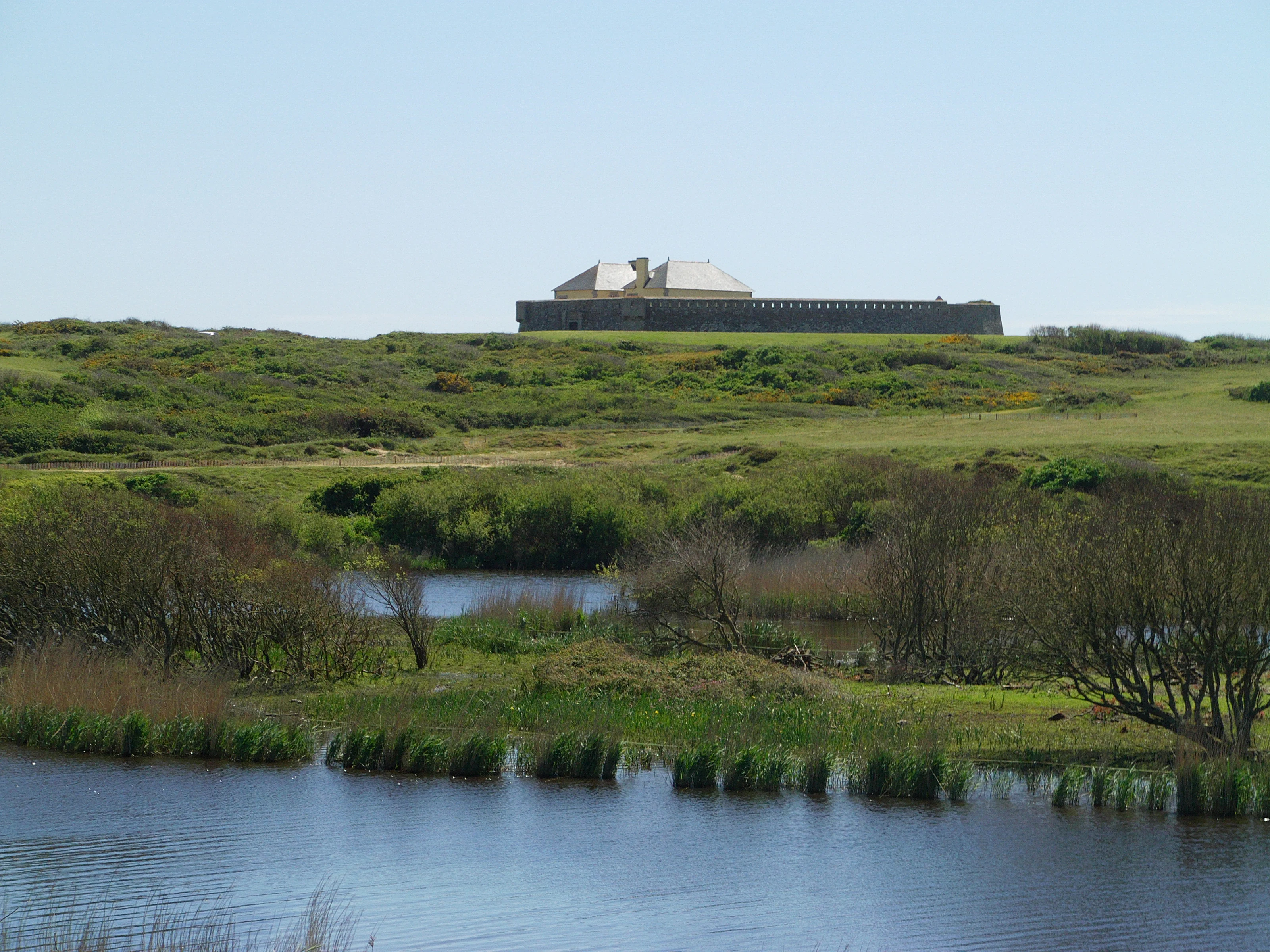
A wide view of a stone fort with a gabled roof sitting on a green grassy hill above a marshy pond area.
The historic Fort du Loch overlooking the coastal wetlands of the nature reserve.

Réserve naturelle régionale des étangs du Petit et du Grand Loc'h history and protected-area timeline

The landscape of the Étangs du Petit et du Grand Loc'h reflects centuries of natural and human transformation. The site was originally a marine inlet, or ria, connected to the Atlantic Ocean. The ancient shoreline is still visible to the north of the Grand Loc'h, marking the original extent of the former sea arm.

In 1884, the Grand Loc'h was progressively drained and converted into polders for agricultural use, marking a significant human intervention in the hydrology of the area. The Petit Loc'h remained an open, shallow freshwater body influenced by the sea, with a flap valve later installed to manage water levels and salinity exchange.

By the early twenty-first century, the ecological value of these wetlands had become widely recognised. On 20 December 2008, the regional council of Brittany formally classified the area as a regional nature reserve, creating the RNR197 designation and placing the site under structured conservation management. The reserve has since been managed by the Fédération départementale des chasseurs du Morbihan, an unusual choice that reflects the strong role of hunting federations in regional nature reserve management in France.

Réserve naturelle régionale des étangs du Petit et du Grand Loc'h landscape and geographic character

The reserve occupies a narrow coastal band of about three kilometres near Guidel, west of Lorient. Its landscape is shaped by the contrast between the open water of the Petit Loc'h and the low-lying, reclaimed plains of the Grand Loc'h, which run in parallel along the coast.

The Petit Loc'h is a shallow freshwater pond whose water level and salinity exchange are regulated by a flap valve connecting it to the nearby sea. The Grand Loc'h is characterised by former polders, ponds, and seasonally flooded meadows arranged along the Saudraye stream, giving the area a flat, water-dominated character.

Dunes and intradunal depressions add further geological variety to the reserve, creating small but ecologically important variations in soil moisture and vegetation. The site therefore combines water bodies, low-lying wet meadows, and sandy coastal forms into a compact but varied wetland landscape.

Réserve naturelle régionale des étangs du Petit et du Grand Loc'h ecosystems, habitats, and plant life

The ecological identity of the reserve rests on a mosaic of freshwater, transitional, and damp terrestrial habitats. Among the most remarkable features are intradunal depressions and megaphorbiaies, the tall herb communities that develop on moist, nutrient-rich soils.

Wetland vegetation is particularly diverse. Characteristic species include Puccinellia distans (a saline-tolerant grass) and Potamogeton berchtoldii, an aquatic plant typical of shallow fresh waters. The flora also supports orchids adapted to damp habitats, notably the lax-flowered orchid (Orchis laxiflora), the green-winged orchid (Anacamptis morio), and the marsh helleborine (Epipactis palustris). On the drier southern edge of the site, species such as Potentilla neumaniana, Asterolinon linum-stellatum, and the sand toadflax (Linaria arenaria) reflect transitional zones between wetland and dune habitats.

The combination of open water, wet meadows, and dune depressions gives the reserve its distinctive ecological character, supporting both aquatic and terrestrial species within a small coastal area.

Réserve naturelle régionale des étangs du Petit et du Grand Loc'h wildlife and species highlights

Despite its modest size, the reserve supports a dense and varied fauna. Mammals include the European otter, a key indicator of healthy freshwater systems, as well as the European badger and at least eight species of bats.

The most prominent feature of the reserve's wildlife is its rich avifauna, with 147 recorded bird species. Waders dominate, particularly during migration and winter. Regular visitors and residents include oystercatcher, curlew and whimbrel, avocet, bar-tailed and black-tailed godwits, common redshank, spotted redshank, greenshank, ruff, common, green and wood sandpipers, curlew and sanderling, knot, little stint, dunlin, ringed and little ringed plovers, and jack and common snipes. Marine birds such as terns and gulls also use the site. The reserve is a regular stopover for ospreys, whose fishing behaviour along the ponds is a notable sight.

Invertebrates include the Mercury damselfly, a Species of European conservation interest, and the willowherb hawk-moth. Reptiles are represented by the grass snake, the slow worm, the common wall lizard, and the European green lizard, contributing to the broader biodiversity of the site.

Réserve naturelle régionale des étangs du Petit et du Grand Loc'h conservation status and protection priorities

The reserve's conservation significance lies in its protection of a rare sequence of coastal freshwater habitats in Brittany. By safeguarding both open freshwater ponds and former polders from further drainage or development, the reserve preserves hydrological conditions that have become scarce along the French Atlantic coast.

Its designation as a regional nature reserve in 2008 provided formal protection against habitat degradation and established a structured framework for monitoring biodiversity. The reserve plays a particularly important role in supporting migratory and wintering waterbirds along the Atlantic flyway, serving as both a stopover and a refuge during harsh weather conditions.

Management by the Fédération départementale des chasseurs du Morbihan reflects a broader model in France where hunting federations act as stewards of regional nature reserves. This arrangement supports ongoing habitat management, ecological monitoring, and the maintenance of wetland conditions favourable to species of conservation concern such as the European otter and the Mercury damselfly.

Réserve naturelle régionale des étangs du Petit et du Grand Loc'h cultural meaning and human context

The reserve reflects the long interaction between human activity and coastal hydrology in southern Brittany. The transformation of the former ria into polders in 1884, and the later installation of a flap valve to control the exchange between the pond and the sea, illustrates the historically close management of coastal wetlands by local communities.

The name Loc'h, meaning 'lake' or 'pond' in Breton, also signals the site's longstanding place in regional identity and traditional land use. Today, the reserve balances its agricultural and hydrological heritage with contemporary biodiversity conservation, adding a cultural dimension to its ecological role.

Top sights and standout views in Réserve naturelle régionale des étangs du Petit et du Grand Loc'h

The reserve's standout features include the Petit Loc'h freshwater pond with its sea-control valve, the historic Grand Loc'h polders dating from 1884, and the unusual habitat mosaic of open water, wet meadows, intradunal depressions, and megaphorbiaies within a single coastal strip. The site is a nationally recognised wetland for migrating and wintering waterbirds, with 147 recorded bird species providing exceptional diversity for such a small area.

Equally notable is the reserve's blend of natural and cultural heritage, combining a former marine ria, reclaimed farmland, and active conservation under the Morbihan Hunters' Federation. This combination gives the Étangs du Petit et du Grand Loc'h a distinctive character among Brittany's regional nature reserves.

Best time to visit Réserve naturelle régionale des étangs du Petit et du Grand Loc'h

The reserve is most rewarding for visitors during the cooler months, when migratory waders arrive from the north and settle along the ponds and meadows. Autumn and winter offer the richest birdwatching, with curlews, godwits, plovers, and other shorebirds using the site as a stopover or wintering ground.

Spring brings renewed water levels and the flowering of wetland plants, including several orchid species characteristic of damp meadows, while summer offers warmer conditions and active reptile and insect life around the pond edges. As the reserve lies next to the coastal road near Lorient, it can be experienced comfortably throughout much of the year, though winter often delivers the most concentrated wildlife displays.
Monthly climate preview

Long term temperature and precipitation records across representative coordinate sampling points

Annual Climate Normals and Weather Patterns at Réserve naturelle régionale des étangs du Petit et du Grand Loc'h

Representative coordinates document sustained monthly shifts in temperature and precipitation across the protected area. Detailed climate normals reveal complete twelve month climatology profiles for advanced geographical comparison.
Annual mean12 °C
6 °C18 °C
Jan
Feb
Mar
Apr10°
May13°
Jun16°
Jul18°
Aug18°
Sep16°
Oct13°
Nov
Dec
Warmest month
August

18.1 °C

Coolest month
February

6.1 °C

Wettest month
December

3.5 mm/day

Driest month
July

1.6 mm/day

Park location guide

Geography guide, regional context, and park location map for Réserve naturelle régionale des étangs du Petit et du Grand Loc'h

Réserve naturelle régionale des étangs du Petit et du Grand Loc'h park geography, regions, and map view in France

Understand where Réserve naturelle régionale des étangs du Petit et du Grand Loc'h sits in France through a broader geographic reading of the surrounding landscape, nearby location context, and its mapped position within the national park landscape.

How Réserve naturelle régionale des étangs du Petit et du Grand Loc'h fits into France

France is a unitary semi-presidential republic and one of the world's largest economies. It borders Belgium, Luxembourg, Germany, Switzerland, Italy, Monaco, Andorra, and Spain, with a maritime border to the United Kingdom. The country is known for its cultural influence, art, cuisine, and political history spanning centuries.

Wider geography shaping Réserve naturelle régionale des étangs du Petit et du Grand Loc'h in France

France is located in Western Europe. Metropolitan France extends from the Rhine to the Atlantic Ocean and from the Mediterranean Sea to the English Channel and North Sea. The country borders Belgium, Luxembourg, Germany, Switzerland, Italy, Monaco, Andorra, Spain, and has a maritime border with the United Kingdom.

Map view of Réserve naturelle régionale des étangs du Petit et du Grand Loc'h

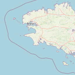
Use this park location map to pinpoint Réserve naturelle régionale des étangs du Petit et du Grand Loc'h in France, understand its exact geographic position, and read its mapped placement within the surrounding landscape more clearly.

Pigeon | © OpenStreetMap contributors

Location context for Réserve naturelle régionale des étangs du Petit et du Grand Loc'h

BretagneMorbihan

Explore protected coastal wetlands, shallow ponds, and diverse regional scenery.

Visualizing Réserve naturelle régionale des étangs du Petit et du Grand Loc'h Landscapes and Habitats

Visual documentation reveals the distinctive terrain, open freshwater bodies, and wetland habitats shaping Réserve naturelle régionale des étangs du Petit et du Grand Loc'h. Photographic records provide clear insight into the protected coastal landscape, local vegetation patterns, and wildlife environments across the reserve.

A wide view of a stone fort with a gabled roof sitting on a green grassy hill above a marshy pond area.

Park atlas

Compare regional wetlands, coastal reserves, and protected areas across western France.

Parks Near Réserve Naturelle Régionale des Étangs du Petit et du Grand Loc'h

Browse nearby protected landscapes and coastal wetland reserves connected to the regional geography of Brittany. Comparing adjacent conservation areas reveals broader patterns in coastal bird habitats and lowland water ecosystems.
A watercolor painting showing a soft, panoramic view of a coastal wetland with small islands in the distance and grassy foreground dunes.
Regional parkBretagne
About 37 km away#1 closest

East

Parc naturel régional du Golfe du Morbihan: Coastal Landscape and Marine Park Geography

Protected maritime territory and island geography in Bretagne

Covering over 80,000 hectares of combined land and marine space, Parc naturel régional du Golfe du Morbihan offers a unique view into the intersection of Atlantic coastal heritage and environmental conservation. Learn about the park's structural role in the Bretagne region through its intricate network of inlets, peninsulas, and marshland habitats that define its distinctive maritime character.

Area
642 km²
Established
2014
IUCN
V
Nature reserveFinistère
About 48 km away#2 closest

Northwest

Vallée de l'Aulne Nature Reserve: A Detailed Mapping of Finistère River Valley Geography

Protected riparian landscapes, watershed ecology, and regional basin boundaries

The Vallée de l'Aulne serves as a central artery for the natural landscapes of western France. Spanning from inland Brittany toward the Atlantic, this protected reserve encompasses riverine corridors, bocage terrain, and tidal estuary zones. Use this detailed profile to examine the geographic distribution of protected habitats, river basin features, and the integrated environmental protections that define this key Finistère landscape.

Area
35.64 km²
Established
2014
Relief
Lowland
Climate
Temperate
A watercolor painting showing a soft, stylized landscape of green hills, marshy fields, and patches of pink wildflowers or heathland against a white background.
Nature reserveBretagne
About 50 km away#3 closest

North

Réserve naturelle régionale des landes et marais de Glomel: Protected Bog and Heathland Atlas

A rare inland wetland refuge within the Bretagne Montagnes Noires

Explore the geographic mosaic of the Réserve naturelle régionale des landes et marais de Glomel, a protected area in Bretagne comprising dual sites of peat bogs, wet heaths, and marshy meadows. This atlas entry details the internal terrain, including the Grazius stream network and the historic canal environment, essential for understanding the habitat distribution and conservation of this distinct inland landscape.

Area
1.078 km²
Established
2008
IUCN
IV
Relief
Upland
A watercolor painting showing a wide, panoramic view of a marshy landscape with green clumps of grass in the foreground and soft purple hills in the distance.
Nature reserveFinistère
About 73 km away#4 closest

Northwest

Réserve naturelle nationale du Venec: Protected Peatland and Monts d'Arrée Geography

A core nature reserve and active sphagnum bog ecosystem in Finistère

Located in central Brittany, the Réserve naturelle nationale du Venec represents the only remaining large, active raised bog in the region. This protected area within the Finistère department offers deep insight into the geomorphology of the Yeun-Elez basin, mapping the transition from granite-edged dry moorland through marshy transition zones to the central, ombrotrophic peat dome.

Area
3.341 km²
Established
1993
IUCN
IV
Relief
Upland
A horizontal watercolor illustration of a soft green landscape with rolling hills, patches of grass, and distant tree lines against a white background.
Nature reserveBretagne
About 76 km away#5 closest

North

Réserve naturelle régionale des landes et tourbières du Cragou et du Vergam: Regional Park Geography

Protected granite ridges and Atlantic peatland ecosystems in Finistère

The Réserve naturelle régionale des landes et tourbières du Cragou et du Vergam stands as a critical reference for understanding Breton upland ecology. Spanning the Monts d'Arrée, these protected sites provide a distinct map of wet heath, acidic flushes, and diverse botanical habitats that define the inland character of northwestern France.

Area
3.434 km²
Established
2008
IUCN
IV
Relief
Upland
Watercolor painting of soft, rolling green hills and pinkish, jagged coastal cliffs on a white background.
Nature reserveBretagne
About 87 km away#6 closest

Northwest

Réserve naturelle régionale des sites d'intérêt géologique de la presqu'île de Crozon: Protected Area and Atlas

Coastal geological heritage and maritime landscapes in the heart of Bretagne.

Spanning 27 distinct locations, the Réserve naturelle régionale des sites d'intérêt géologique de la presqu'île de Crozon documents millions of years of volcanic, tectonic, and sedimentary evolution. The reserve anchors its scientific value in its open-air exposures of Paleozoic rock, while simultaneously providing a sanctuary for specialized coastal flora and fauna along the Atlantic edge of Bretagne.

Area
1.564 km²
Established
2013
IUCN
IV
Relief
Upland
Nature reserveLoire-Atlantique
About 88 km away#7 closest

East

Réserve naturelle régionale de l'étang du pont de fer: Protected Wetlands of Loire-Atlantique

Coastal freshwater pond, wooded buffers, and wetland connectivity.

This regional nature reserve encompasses a sizeable freshwater pond and surrounding marshes, serving as a vital link in the chain of wetlands between the Vilaine estuary and the Guérande region. Its distinctive landscape, defined by floating sedge islets and dense alder woodland, supports a high density of avifauna and rare plant species. As a key component of the protected terrain in Loire-Atlantique, the reserve offers insight into coastal wetland ecosystems and their function as biodiversity corridors in western France.

Area
0.626 km²
Established
2008
IUCN
IV
Relief
Lowland
Nature reserveBretagne
About 90 km away#8 closest

North

Réserve naturelle régionale des landes, prairies et étangs de Plounérin: Protected Habitat Atlas

Inland Bretagne landscape mosaic and regional nature reserve mapping

This protected area in the heart of Brittany serves as a vital refuge for heathland, meadows, and ponds. Examine the site's mapped boundaries and understand its role as an IUCN Category IV conservation landscape within the broader geography of the Côtes-d'Armor department.

Area
1.607 km²
Established
2016
IUCN
IV

Common questions about visiting, size, designation, and location context for Réserve naturelle régionale des étangs du Petit et du Grand Loc'h

Réserve naturelle régionale des étangs du Petit et du Grand Loc'h FAQs for park facts, access, geography, and protected area context

Find quick answers about Réserve naturelle régionale des étangs du Petit et du Grand Loc'h, including protected-area facts, park geography, trail and visitor context, and how the park fits into its surrounding country and regional landscape.
MoriAtlas Explorer

Continue Your Protected Areas Search Across the Global Atlas

Deepen your exploration by continuing the structured search for national parks and protected areas worldwide. Utilize the comprehensive filtering capabilities to compare different conservation landscapes and refine your understanding of global park geography. Discover more about the distribution and characteristics of protected natural areas.

Global natural geography