Mori Atlas logo
Nature reserveRéserve naturelle régionale du lac de Malaguet

Tracing the medieval water boundaries and forest mosaic of the Massif Central margins

Réserve naturelle régionale du lac de Malaguet: A Protected Wetland and Regional Nature Reserve

Réserve naturelle régionale du lac de Malaguet represents a significant protected area within the Haute-Loire department of Auvergne-Rhône-Alpes. This regional nature reserve preserves a centuries-old artificial lake and its surrounding wetland, forest, and meadow ecosystems, providing critical habitats for the European otter, various bat species, and diverse waterbirds. Our detailed atlas maps the intersection of this historic hydraulic heritage and modern biodiversity stewardship across the gently sloping terrain of the Borne occidentale valley.

wetlandlakeuplandotter habitatwaterbirdsamphibians

Réserve naturelle régionale du lac de Malaguet

Nature reserve

Park overview

Structured park overview, official facts, and landscape profile for Regional Nature Reserve of Lake Malaguet

Regional Nature Reserve of Lake Malaguet park facts, protected area profile, and essential visitor context

Review the core facts for Regional Nature Reserve of Lake Malaguet, including designation, size, terrain, visitor scale, habitats, and operating context in one park-focused overview.

About Regional Nature Reserve of Lake Malaguet

The Regional Nature Reserve of Lake Malaguet sits in the central-southern uplands of France, within the Haute-Loire department of the Auvergne-Rhône-Alpes region. The site occupies a relatively compact footprint on the communes of Félines, Monlet, and Sembadel, in the transitional landscapes between the Margeride highlands and the hills of the Livradois-Forez area. Its protected perimeter wraps around an artificial lake and its immediate hydrographic, forest, and meadow surroundings, creating a representative sample of upland central French ecosystems.

The lake itself is the defining feature of the reserve. Originally created by the barons of Allègre through the construction of a dam on the Borne occidentale, it has been referenced in written records since the 14th century. Over the following centuries it served as a working water resource, supporting fish farming, multiple mills, a sawmill, a passementerie (textile trim workshop), a flour mill, and eventually a small hydroelectric facility in the early 20th century. The reserve today preserves the hydrological and ecological integrity of this long-influenced landscape.

Ecologically, the protected area sits at the meeting point of several habitat types. The lake and its marshy margins support aquatic vegetation and waterfowl, while surrounding woodlands and open meadows provide complementary conditions for forest birds, insects, amphibians, and larger mammals. This habitat diversity, within a relatively small perimeter, is a defining characteristic of the reserve and the main reason it was elevated from a ZNIEFF inventory site to a formal regional protection status in 2014.

As a regional rather than national reserve, Lake Malaguet is part of France's network of Reserves Naturelles Régionales, smaller-scale protected areas that emphasize regional management responsibility and close ties to local stakeholders. Administration is entrusted to the Parc naturel régional Livradois-Forez, an institution with deep experience in balancing rural land use, cultural heritage, and biodiversity conservation across the broader Livradois-Forez territory.

Quick facts and research context for Regional Nature Reserve of Lake Malaguet

Established by deliberation of the Auvergne Regional Council on 23 September 2014, the reserve lies on the territory of the communes of Félines, Monlet, and Sembadel in Haute-Loire. It is classified as a Regional Nature Reserve (Réserve Naturelle Régionale) under IUCN Category IV and is managed by the Parc naturel régional Livradois-Forez. The protected area covers approximately 54 hectares and is built around Lake Malaguet, an artificial body of water created by the barons of Allègre on the Borne occidentale and first documented in the 14th century.

Protection and recognition

Examine documented terrestrial protection metrics and official conservation status data.

Réserve naturelle régionale du lac de Malaguet Protection Status and Designated Area Record

Comprehensive protected area records outline the terrestrial scope and official registration details for Réserve naturelle régionale du lac de Malaguet. Structured conservation data provides reliable framework context for reviewing international database entries.

Protection details

Protection scope
Terrestrial
Transboundary protection
No
WDPA ID
555561978
Park context

Deeper park guide and search-rich context for Regional Nature Reserve of Lake Malaguet

Regional Nature Reserve of Lake Malaguet history, landscape, wildlife, and travel context

Explore Regional Nature Reserve of Lake Malaguet through its history, landscape character, ecosystems, wildlife, conservation priorities, cultural context, and seasonal travel timing in a structured park guide built for atlas discovery and search intent.

Why Regional Nature Reserve of Lake Malaguet stands out

The reserve is best known for combining a centuries-old artificial lake with unusually rich biodiversity for its size. Its emblematic species is the European otter, a strong indicator of clean freshwater and healthy riparian habitat. The lake and its surroundings also host a wide variety of breeding and migratory waterbirds, eleven bat species, and a notable population of common toads, making the site a compact showcase of upland wetland, forest, and meadow ecology. Equally distinctive is the reserve's layered human history: the same water that once powered mills, a sawmill, and later a small hydroelectric installation now anchors a modern biodiversity protection project, illustrating the transition from utilitarian exploitation of water resources to ecological stewardship.

Regional Nature Reserve of Lake Malaguet history and protected-area timeline

The history of the Lake Malaguet site stretches back to the Middle Ages, when the barons of Allègre built a dam across the Borne occidentale to create an artificial lake. Already noted in the 14th century, the lake was used primarily for fish farming, and its stored water was gradually harnessed over the following centuries for industrial and artisanal activity. Mills, a sawmill, a passementerie, a flour mill, and, in the early 20th century, a small hydroelectric installation all drew on its hydraulic power, marking the site as a multi-purpose rural-industrial water resource well into the modern era.

Recognition of the site's ecological value came much later. In 1982, Lake Malaguet and its surroundings were included in the ZNIEFF inventory of natural areas of ecological, faunistic, and floristic interest, formally flagging the biological importance of the lake, its wetlands, and associated woodlands. Around the beginning of the 1990s, managers began pursuing stronger protection for the area. A project for a voluntary nature reserve was put forward in 1997, with renewed momentum in 2002 under the stewardship of the Livradois-Forez Regional Natural Park.

The initiative evolved through several iterations. Initially pursued as a project for a voluntary nature reserve, it was reframed in 2004 as a regional nature reserve project, aligning the site with the French regional protection framework. After years of preparation and consultation, the Auvergne Regional Council formally classified Lake Malaguet as a Réserve Naturelle Régionale on 23 September 2014. The reserve is now identified administratively as RNR279 and is managed by the Parc naturel régional Livradois-Forez, which has continued the long tradition of human engagement with the lake in a contemporary conservation role.

Regional Nature Reserve of Lake Malaguet landscape and geographic character

The relief of the reserve is shaped by the modest valley of the Borne occidentale, where the man-made Lake Malaguet occupies a central position. The lake, formed by an old dam, defines the hydrology and visual character of the site, surrounded by gently sloping upland terrain typical of the eastern Massif Central margins. The combination of standing water, periodically inundated margins, and adjacent dry slopes creates a transition between wetland and terrestrial environments within a small area.

Surrounding the lake, the landscape is a mosaic of forested patches and open meadows, with small streams feeding into and out of the lake along the historic dam-controlled watershed. The terrain is gentle rather than dramatic, but the layering of artificial lake, riparian zones, wet meadows, and woodland edges provides the structural diversity that supports the site's biodiversity. The setting also preserves visible traces of past human use, including the historic dam and remnants of former mill sites along the watercourse.

Regional Nature Reserve of Lake Malaguet ecosystems, habitats, and plant life

The reserve protects an unusually compressed cross-section of habitats, which is one of its main ecological strengths. Aquatic and riparian habitats dominate the lake itself, with submerged and emergent vegetation favored by the calm, nutrient-managed waters. Beyond the shoreline, damp meadows, wet woodland margins, drier upland forests, and open grassy areas round out the habitat spectrum, creating a series of ecological transitions within a short distance of the lake.

A wide range of plant species reflects this habitat diversity. Moist-loving flowering plants such as marsh cinquefoil (Comarum palustre), marsh yellow-cress (Rorippa palustris), and various pondweeds occupy the wetter zones, while species like purple foxglove (Digitalis purpurea) and great willowherb (Epilobium hirsutum) thrive in transitional habitats. The reserve also hosts notable lower plants, including the green alga Nitella hyalina and several characteristic lichens, which add to its botanical interest. Wetland habitats provide particularly rich conditions for both flora and fauna, demonstrating the value of even small protected water bodies in central France.

Regional Nature Reserve of Lake Malaguet wildlife and species highlights

The wildlife of the reserve is structured around the lake and its mosaic of surrounding habitats. Among mammals, the European otter is the site's flagship species, an indicator of healthy waterways and intact riparian corridors. It shares the reserve with other forest and countryside mammals, including the stoat (ermine), pine marten, red squirrel, roe deer, and wild boar, which move between woodland and open spaces.

Birds are a notable feature of the reserve, which supports both breeding and migratory species. Open-country species such as the woodlark, tree pipit, yellowhammer, and red-backed shrike are found in the meadows and heath-like edges, while forest specialists including the black woodpecker and treecreeper inhabit wooded areas. The lake and its margins host breeding mallard, Eurasian coot, and grey heron, and also serve as a stopover and feeding site for migratory species such as the osprey and black tern.

The reserve additionally supports a remarkable diversity of bats, with eleven recorded species including the western barbastelle and several noctule species. Reptiles such as the grass snake and viviparous lizard occupy the wet margins and sunny clearings, while amphibians including the alpine newt, palmate newt, and a substantial population of common toad rely on the marshy edges of the lake and its small tributaries. Together, these groups reflect a functional, interconnected ecosystem rather than a narrow single-species habitat.

Regional Nature Reserve of Lake Malaguet conservation status and protection priorities

The conservation significance of the Lake Malaguet reserve lies in its ability to concentrate multiple high-quality habitats into a compact, well-managed perimeter. Its designation as a Réserve Naturelle Régionale under IUCN Category IV reflects its role in protecting specific species and habitat features rather than a vast wilderness, and this targeted approach suits the site's scale. The reserve extends and formalizes the earlier ZNIEFF recognition from 1982, giving the area a stronger legal and management framework.

Management by the Parc naturel régional Livradois-Forez places the site within a wider regional strategy for biodiversity, rural land use, and ecological connectivity in the Livradois-Forez area. The presence of sensitive and legally protected species, including the otter and multiple bat species, gives the reserve measurable ecological importance beyond its size. It also demonstrates the broader conservation value of small wetland-and-forest complexes in central France, where such sites act as stepping stones for biodiversity across a predominantly agricultural and forested matrix.

Regional Nature Reserve of Lake Malaguet cultural meaning and human context

Lake Malaguet carries a deep cultural imprint rooted in medieval seigneurial enterprise. The artificial lake was originally conceived as part of the barons of Allègre's management of the Borne occidentale valley, reflecting the historical pattern of noble-driven water management in the Auvergne highlands. From the Middle Ages onward, the lake was woven into the rural economy, supplying fish and powering successive waves of mill-based activity through the early modern and industrial periods.

The passage of these activities, from mills to a sawmill to a small hydroelectric installation, mirrors the broader transition of rural French landscapes from diversified artisanal production to modernized utilities. Today, the conservation mandate of the reserve represents a further evolution: the lake's water, once harnessed for profit, is now valued primarily for the biodiversity and habitat diversity it sustains. This layered history of artisanal, industrial, and ecological roles gives the reserve a distinctive cultural-territorial identity within the Livradois-Forez cultural landscape, with references in regional historical literature such as local history journals continuing to document its past.

Top sights and standout views in Regional Nature Reserve of Lake Malaguet

A compact but layered protected area in Haute-Loire, the reserve combines medieval hydraulic heritage with strong present-day ecological value. Its emblematic European otter, eleven recorded bat species, and diverse breeding and migratory birdlife make it disproportionately rich for its size. The lake's continuity from 14th-century fish farm to 21st-century biodiversity refuge stands out as a particularly compelling example of long-term landscape transformation.

Best time to visit Regional Nature Reserve of Lake Malaguet

As a small, ecologically focused reserve rather than a heavily visited park, Lake Malaguet offers more atmospheric and wildlife-interest variation across the year than logistical operational ones. Spring and early summer tend to be the most rewarding periods for observing breeding waterbirds on the lake, amphibian activity along the marshy margins, and rich vegetation across the meadows and forests. Late spring and early summer also maximize the chances of spotting woodland and open-country songbirds.

Autumn brings quieter conditions, cooler temperatures, and increased mammalian activity as species such as roe deer and wild boar move more visibly in the surrounding woodlands, while the lake remains an attractive feature in its own right. Winter visits appeal more to those interested in the stillness of the landscape, frozen-edge wetland views, and the migratory waterbirds that periodically use the lake as a stopover. Across all seasons, the reserve rewards visitors interested in ecological detail rather than dramatic vistas, given its modest scale.
Monthly climate preview

Long-term representative point measurements tracking twelve-month thermal and precipitation cycles

Annual Climate Normals and Temperature Patterns at Réserve naturelle régionale du lac de Malaguet

Historical data recorded at a representative elevation of 703 meters establishes multi-year temperature extremes and daily precipitation averages for Réserve naturelle régionale du lac de Malaguet. Detailed monthly climatology breakdowns provide broader context for studying long-term environmental patterns across the protected landscape.
Annual mean9 °C
1 °C19 °C
Jan
Feb
Mar
Apr
May12°
Jun16°
Jul19°
Aug19°
Sep14°
Oct10°
Nov
Dec
Warmest month
July

19.2 °C

Coolest month
January

0.8 °C

Wettest month
May

2.5 mm/day

Driest month
March

1.2 mm/day

Park location guide

Geography guide, regional context, and park location map for Regional Nature Reserve of Lake Malaguet

Regional Nature Reserve of Lake Malaguet park geography, regions, and map view in France

Understand where Regional Nature Reserve of Lake Malaguet sits in France through a broader geographic reading of the surrounding landscape, nearby location context, and its mapped position within the national park landscape.

How Regional Nature Reserve of Lake Malaguet fits into France

France is a unitary semi-presidential republic and one of the world's largest economies. It borders Belgium, Luxembourg, Germany, Switzerland, Italy, Monaco, Andorra, and Spain, with a maritime border to the United Kingdom. The country is known for its cultural influence, art, cuisine, and political history spanning centuries.

Wider geography shaping Regional Nature Reserve of Lake Malaguet in France

France is located in Western Europe. Metropolitan France extends from the Rhine to the Atlantic Ocean and from the Mediterranean Sea to the English Channel and North Sea. The country borders Belgium, Luxembourg, Germany, Switzerland, Italy, Monaco, Andorra, Spain, and has a maritime border with the United Kingdom.

Map view of Regional Nature Reserve of Lake Malaguet

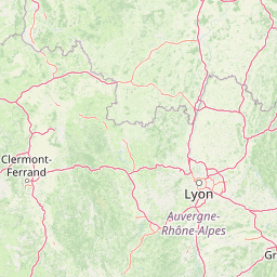
Use this park location map to pinpoint Regional Nature Reserve of Lake Malaguet in France, understand its exact geographic position, and read its mapped placement within the surrounding landscape more clearly.

Pigeon | © OpenStreetMap contributors

Location context for Regional Nature Reserve of Lake Malaguet

Auvergne-Rhône-Alpes
Recorded earthquake history

Explore Historical Earthquake Records near Réserve naturelle régionale du lac de Malaguet

View the historical seismic catalogue for Réserve naturelle régionale du lac de Malaguet. This MoriAtlas resource provides recorded earthquake data organized by proximity and magnitude to help users better understand the historical seismic landscape of this region without implying current hazard or risk.

Réserve naturelle régionale du lac de Malaguet earthquake records

Catalogued events

17 events

Strongest magnitude

Magnitude 3.5

Most recent event

Nov 5, 2001

This history includes earthquakes recorded inside the park or within 50 km of its borders

Park atlas

Compare adjacent wetland reserves, upland forests, and protected landscapes in central France

Other Parks Near Réserve naturelle régionale du lac de Malaguet and Regional Protected Areas

Continue exploring protected areas near Réserve naturelle régionale du lac de Malaguet to compare neighboring wetland habitats, upland forests, and regional nature reserves. Expanding the search helps reveal broader ecological patterns and connected conservation landscapes across the surrounding region.
A watercolor illustration of a serene landscape with rolling hills, a meandering river, and soft light.
Regional parkAuvergne-Rhône-Alpes
37 km away#1 closest

Southeast

Parc naturel régional des Monts d'Ardèche: Protected Landscapes and Geographic Map Context

Volcanic highland terrain within the Auvergne-Rhône-Alpes region

Covering over 248,000 hectares, Parc naturel régional des Monts d'Ardèche represents a significant protected area in the southern Massif Central. The region is marked by its distinctive volcanic sucs, including Mont Gerbier-de-Jonc, and a complex network of Cévenol river valleys. It remains a focal point for understanding the transition between high volcanic plateaus and traditional terraced agricultural slopes in southeastern France.

Area
2,280 km²
Established
2001
IUCN
V
A soft watercolor painting of a rolling landscape with green fields, distant purple hills, and patches of yellow and pink vegetation.
Nature reserveAuvergne-Rhône-Alpes
43 km away#2 closest

North

Réserve naturelle régionale des Jasseries de Colleigne Protected Area and Landscape Atlas

High-altitude moorlands and glacial geography in the Monts du Forez

This regional nature reserve provides a critical look at the Hautes Chaumes du Forez, an upland plateau in the Massif Central characterized by open grasslands and peat bogs. The site serves as a vital case study for the conservation of rare montane habitats maintained through traditional pastoral farming practices. Map the glacial Chorsin valley and explore the diverse botanical landscape contained within these protected high-altitude boundaries.

Area
2.85 km²
Established
1985
IUCN
IV
Relief
Mountain
A horizontal watercolor painting showing a soft, stylized river winding through green hills and forests.
Regional parkAuvergne-Rhône-Alpes
44 km away#3 closest

Northeast

Réserve naturelle régionale des gorges de la Loire: Landscape and Protected Area Geography

Regional nature reserve in the Auvergne-Rhône-Alpes landscape.

The Réserve naturelle régionale des gorges de la Loire protects a rugged stretch of the Loire River valley in the eastern Massif Central. Discover the geographic mosaic of rocky outcrops, shrubby heaths, and woodland slopes that define this protected area, and see how the terrain shapes its distinct biodiversity and river corridor boundaries.

Area
3.55 km²
Established
1988
IUCN
IV
Relief
Upland
A soft watercolor painting depicting rolling green hills and distant faint mountains under a light sky.
Nature reservePuy-de-Dôme
About 57 km away#4 closest

West

Réserve naturelle nationale du rocher de la Jaquette Protected Area and Volcanic Landscape

Explore rocky cliffs and rare entomological habitats in the Puy-de-Dôme region.

Situated on the flanks of a volcanic outcrop above the Rentières valley, this nature reserve protects a diverse habitat mosaic within the Massif Central. The site provides essential breeding grounds for protected raptors and represents one of the most significant insect sites in central France, offering a clear view into regional volcanic ecology and mountain-valley geography.

Area
0.362 km²
Established
1976
IUCN
IV
Relief
Mountain
Nature reserveAuvergne-Rhône-Alpes
About 63 km away#5 closest

Northwest

Réserve naturelle régionale du Puy de Marmant: Volcanic Geography and Protected Terrain

Regional nature reserve in the Auvergne-Rhône-Alpes landscape.

This protected site preserves a prominent volcanic hill and its surrounding dry grasslands within the Limagne basin. The reserve serves as an ecologically significant island, maintaining specialized thermophilous plants and rare geological formations composed of basalt and peperite. It remains an essential reference for understanding the volcanic heritage and unique botanical diversity of the Puy-de-Dôme department.

Area
0.203 km²
Established
1985
IUCN
IV
Relief
Upland
A soft watercolor painting of a wide, rolling landscape with green hills, pale mountain silhouettes in the background, and a faint reddish-brown foreground, presented on a white background.
Natural monumentAuvergne-Rhône-Alpes
66 km away#6 closest

Northwest

Chaîne des Puys - faille de Limagne: Mapping Volcanic and Tectonic Protected Landscapes

Geological exploration of the Auvergne-Rhône-Alpes volcanic chain

Spanning a rhythmic skyline of roughly eighty volcanoes, the Chaîne des Puys - faille de Limagne represents a premier site for studying continental rifting and volcanic landforms. This protected monument offers a clear view into the interplay between the ancient mountain basement, the massive Limagne fault, and the resulting volcanic edifices that define the regional identity of the Auvergne-Rhône-Alpes area.

Area
242.23 km²
Established
2018
Relief
Mountain
Climate
Temperate
Watercolor painting of a soft, hazy mountain landscape with rolling green fields and a distant forest, set against a light, warm, pale background.
Nature reserveAuvergne-Rhône-Alpes
66 km away#7 closest

West

Réserve naturelle régionale des tourbières du Jolan et de la Gazelle: Geographic Overview

A vital wetland protected area in the Auvergne volcanic highlands.

Located in the Cantal department, the Réserve naturelle régionale des tourbières du Jolan et de la Gazelle features a unique collection of peatland habitats, trembling mires, and acidic grasslands. This area sits within the broader volcanic terrain of the Parc naturel régional des Volcans d'Auvergne, offering a protected catchment for diverse marshland flora and fauna.

Area
1.558 km²
Established
2018
IUCN
IV
Relief
Highland
Watercolor illustration of green fields, a river, and mountains under a soft pink and yellow sky
National parkOccitanie
82 km away#8 closest

South

Cévennes National Park: Explore its Mapped Terrain and Protected Landscape in Occitanie

Discover the unique geographic context and park boundaries.

Cévennes National Park, situated in Occitanie, France, offers a rich exploration of mid-mountain Mediterranean geography. As a protected landscape, its mapped terrain features dramatic limestone plateaus, deep river gorges, and distinct granite massifs. This entry provides essential geographic context for Cévennes National Park, highlighting its unique natural features and its significance as a protected area within the broader regional atlas.

Area
937 km²
Established
1970
IUCN
V
Visitors
800K annual

Common questions about visiting, size, designation, and location context for Regional Nature Reserve of Lake Malaguet

Regional Nature Reserve of Lake Malaguet FAQs for park facts, access, geography, and protected area context

Find quick answers about Regional Nature Reserve of Lake Malaguet, including protected-area facts, park geography, trail and visitor context, and how the park fits into its surrounding country and regional landscape.
MoriAtlas Explorer

Continue Your Protected Areas Search Across the Global Atlas

Deepen your exploration by continuing the structured search for national parks and protected areas worldwide. Utilize the comprehensive filtering capabilities to compare different conservation landscapes and refine your understanding of global park geography. Discover more about the distribution and characteristics of protected natural areas.

Global natural geography