

Mori Atlas logo
Nature reserveRéserve naturelle régionale du marais de Reuves

Mapping the calcareous marshes, alluvial forests, and rare wetland ecosystems of this French nature reserve.

Réserve naturelle régionale du marais de Reuves: A Protected Wetland Landscape in Grand Est

(Réserve naturelle régionale du marais de Reuves (RNR31))

The Réserve naturelle régionale du marais de Reuves protects a significant fragment of the historic Marais de Saint-Gond in the Marne department. This nature reserve preserves a diverse mosaic of calcareous marshes, peat-forming bog zones, and willow woodlands within a predominantly agricultural landscape. By maintaining these essential water-based habitats, the area serves as a critical refuge for wetland flora and fauna within the broader geography of the Grand Est region.

wetland reservecalcareous marshespeatlandwet woodlandalluvial forestamphibians

Réserve naturelle régionale du marais de Reuves

Nature reserve

Park overview

Structured park overview, official facts, and landscape profile for Réserve naturelle régionale du marais de Reuves

Réserve naturelle régionale du marais de Reuves park facts, protected area profile, and essential visitor context

Review the core facts for Réserve naturelle régionale du marais de Reuves, including designation, size, terrain, visitor scale, habitats, and operating context in one park-focused overview.

About Réserve naturelle régionale du marais de Reuves

The Réserve naturelle régionale du marais de Reuves is a compact wetland reserve in northern France, designed to protect a surviving portion of the historically extensive Marais de Saint-Gond. The Saint-Gond marshes once formed a significant wetland landscape in the Marne department, and today only fragments remain. The reserve, established in 2008, holds one of these fragments and acts as an anchor of biodiversity within a surrounding region dominated by intensive agriculture.

Ecologically, the reserve is shaped by the interplay of calcareous groundwater and the topographic conditions typical of the Saint-Gond basin. Pools and calcareous marshes occur alongside willow-dominated wet woodland, alluvial forest, peat-forming areas, and drier grasslands and swards. This habitat diversity is central to the site's identity; rather than protecting a single habitat type, the reserve conserves a working wetland mosaic that supports many species tied to specific microhabitats.

The reserve is small by national standards, but its protected status allows active management aimed at maintaining open water, preventing excessive woodland encroachment after agricultural abandonment, and safeguarding peat-forming processes. Its integration into a broader network of designations, including Natura 2000 and ZICO classifications, highlights its significance for the regional conservation strategy. For visitors and local communities, the reserve also serves as an accessible introduction to the wetland heritage of Champagne, with an interpretation trail allowing direct contact with the landscape.

Quick facts and research context for Réserve naturelle régionale du marais de Reuves

The Réserve naturelle régionale du marais de Reuves (RNR31) is a French regional nature reserve situated in the commune of Reuves, in the Marne department of Grand Est. It covers approximately 64 hectares and forms part of the larger Marais de Saint-Gond wetland complex, about twelve kilometers north of Sézanne.

Classified as a regional nature reserve on 21 April 2008, the site is IUCN Category IV and is managed by the Conservatoire d'espaces naturels de Champagne-Ardenne. It overlaps with a ZNIEFF of type I, a ZICO Important Bird Area, and a Natura 2000 site, all focused on the Marais de Saint-Gond.

Protection and recognition

Documented terrestrial protected area designation and management scope details

Réserve naturelle régionale du marais de Reuves Protection Status

Terrestrial protected area records for Réserve naturelle régionale du marais de Reuves outline official conservation status and management scope. Documented recognition metadata supplies verified administrative details for structural park analysis.

Protection details

Protection scope
Terrestrial
Transboundary protection
No
WDPA ID
555514361
Park context

Deeper park guide and search-rich context for Réserve naturelle régionale du marais de Reuves

Réserve naturelle régionale du marais de Reuves history, landscape, wildlife, and travel context

Explore Réserve naturelle régionale du marais de Reuves through its history, landscape character, ecosystems, wildlife, conservation priorities, cultural context, and seasonal travel timing in a structured park guide built for atlas discovery and search intent.

Why Réserve naturelle régionale du marais de Reuves stands out

The reserve is best known for protecting a representative fragment of the Marais de Saint-Gond, one of the notable traditional wetland complexes of the Champagne region. It preserves a layered mosaic of calcareous marshes, ponds, alluvial and willow woodland, peatland, and open grasslands within a small footprint. It is also recognized for the richness of its wetland biodiversity in a heavily cultivated landscape. The site hosts rare plants such as the magnificent catchfly and marsh hog's fennel, and supports characteristic wetland fauna including marsh harriers, great crested newts, and protected dragonflies such as the Mercury bluet.
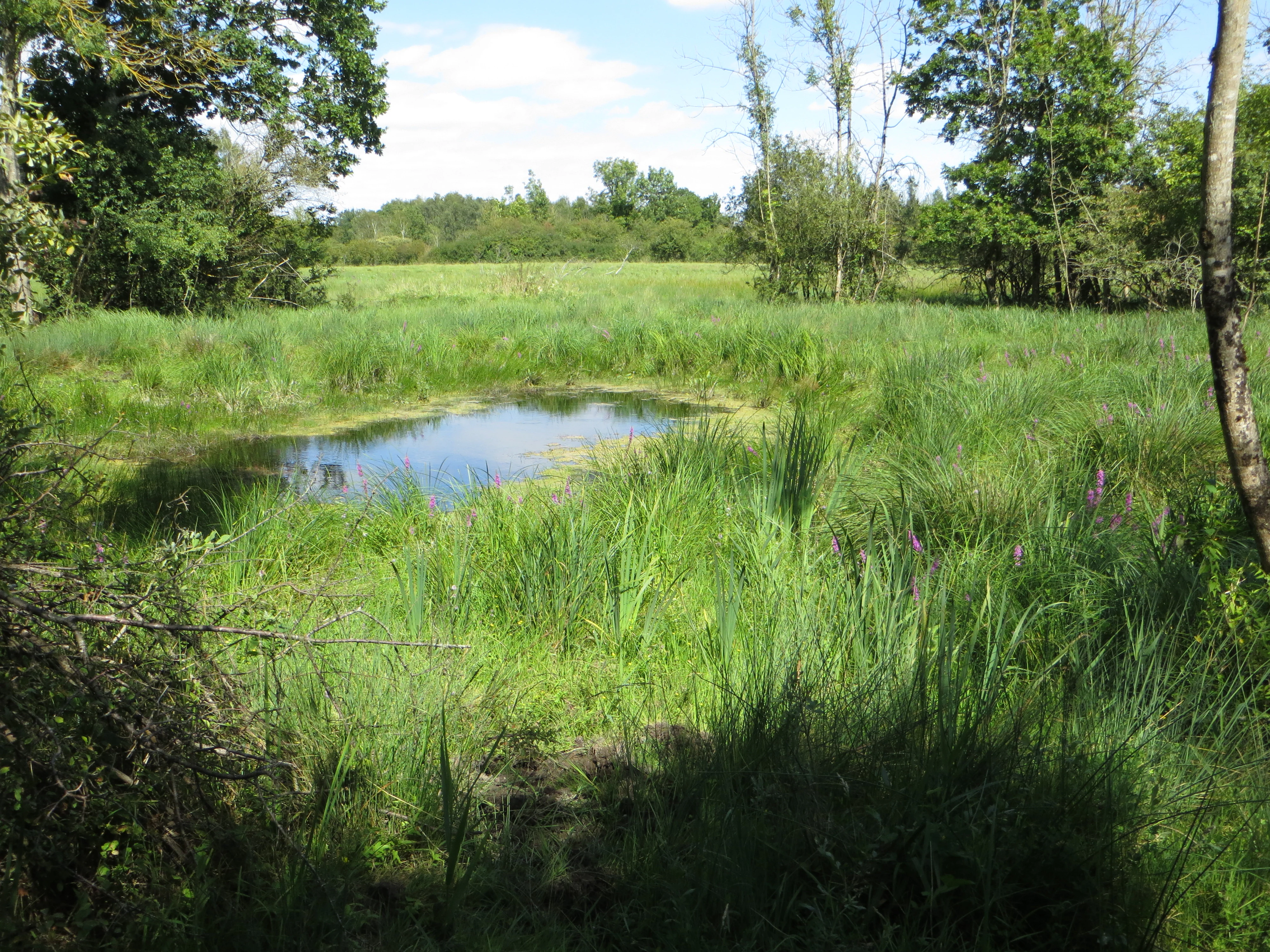
Marais de Reuves landscape
View of various marshland systems including a ditch, sedge marsh, wet meadow, and dry grassland

Réserve naturelle régionale du marais de Reuves history and protected-area timeline

The Marais de Saint-Gond, the larger wetland system of which the reserve is part, was extensively drained during the 1960s, a transformation that significantly reduced the area of open marsh and altered the hydrology of the region. In the decades that followed, the abandonment of some traditional agricultural practices contributed to the gradual closure of open habitats as woody vegetation expanded.

In response to these changes, the area received its first formal protection in 1995, when it was designated as a volontaire nature reserve on 13 January 1995. The protected area was later reclassified and formally established as the Réserve naturelle régionale du marais de Reuves by regional deliberation on 21 April 2008, reflecting an upgraded, long-term conservation commitment. Since then, the site has been managed by the Conservatoire d'espaces naturels de Champagne-Ardenne under multi-year management plans, with the 2010-2015 plan marking an early phase of structured conservation work.

Réserve naturelle régionale du marais de Reuves landscape and geographic character

The reserve sits within the Marais de Saint-Gond, a low-lying wetland region in the Marne department. Its terrain is shaped by calcareous geology, gentle topographic variation, and a hydrology historically defined by seasonal saturation and slow-moving waters. Within a small area, the landscape transitions between open water in the form of ponds and pools, open calcareous marshes, and pockets of peat-accumulating wet ground.

Around and between these open wetland areas, the reserve includes stands of willow wet woodland (saulaie) and alluvial forest, reflecting the transition zones where waterlogged soils support tolerant tree species. Drier micro-sites host grasslands and short swards, providing open structure within the broader mosaic. This combination of open and wooded wetland, interspersed with enhanced ground moisture, gives the reserve a layered visual character in which water, marsh vegetation, and woodland are closely interwoven.

Réserve naturelle régionale du marais de Reuves ecosystems, habitats, and plant life

The Marais de Reuves supports a particularly rich concentration of wetland habitats for its size. Calcareous marshes and seasonal pools form one ecological core, while willow and alluvial woodland represent another, supporting species adapted to periodically flooded conditions. Peat-forming areas within the reserve add a further dimension, maintaining conditions favorable to moisture-dependent plants and invertebrates.

The habitat mosaic is the foundation of the reserve's biodiversity. Open marsh vegetation and pools support aquatic and semi-aquatic flora, while grasslands provide space for herbaceous species that depend on periodic disturbance or mowing. Wooded zones add structural diversity, providing nesting, shelter, and feeding resources for a range of birds, amphibians, and invertebrates. Together, these habitats create a functional wetland system that mirrors, in miniature, the structure of the original Marais de Saint-Gond.

Réserve naturelle régionale du marais de Reuves wildlife and species highlights

The fauna of the Marais de Reuves reflects the wetland character of the reserve. The avifauna is particularly notable, with the marsh harrier and the hen harrier among the recorded birds, along with the red-backed shrike, a species typical of edge habitats where open ground meets shrubs and taller vegetation. These species give the reserve a strong birdwatching profile within the broader agricultural landscape.

Amphibians also play a significant role in the reserve's wildlife identity. The great crested newt, a species of conservation concern across much of Europe, is present, along with the European tree frog, both of which rely on the network of ponds and pools for breeding. Invertebrate diversity is high and includes several protected or rare species, such as the Mercury bluet, a damselfly tied to clean flowing and well-vegetated waters, the slender ringed dragonfly, and the marsh fritillary butterfly, which is protected at the national level in France.

Réserve naturelle régionale du marais de Reuves conservation status and protection priorities

The reserve's conservation value lies in its function as a refugium for wetland biodiversity in a region where wetlands have been heavily reduced. Although small, it preserves a representative cross-section of the ecological elements that once characterized the Marais de Saint-Gond, including open marsh, peatland, and wet woodland. The mosaic of habitats is what gives the site its resilience and ecological meaning.

The reserve is supported by a layered set of conservation designations. It is a regional nature reserve under French law and also falls within a ZNIEFF of type I, a ZICO Important Bird Area dedicated to the Marais de Saint-Gond, and a Natura 2000 site focused on the same wetland complex. These overlapping designations reflect both the local and the broader European importance of the Saint-Gond marshes for migratory birds, amphibians, and wetland invertebrates, and they help anchor conservation efforts within a wider, coordinated framework.

Réserve naturelle régionale du marais de Reuves cultural meaning and human context

The Marais de Saint-Gond carries long-standing regional significance as one of the traditional wetland landscapes of the Champagne countryside. Historically, such marshes shaped local land use, agriculture, and settlement patterns, and the drainage of the 1960s marked a major turning point in the relationship between the local population and the land.

The reserve today reflects a renewed recognition of the value of these landscapes. Wetlands of this type are increasingly seen as part of regional natural heritage rather than as obstacles to farming, and the establishment of the reserve in 1995 and its formal classification in 2008 mark a community and institutional shift toward protecting and interpreting this heritage. The presence of a pedagogical trail on the site, known as the sentier des rainettes, also ties the reserve to local education and place-based awareness of wetland landscapes.

Top sights and standout views in Réserve naturelle régionale du marais de Reuves

A compact Champagne wetland reserve anchored in the surviving fragment of the Marais de Saint-Gond, the site stands out for combining calcareous marshes, ponds, willow wet woodland, peatland, and grasslands within a small protected footprint. It is one of the few places in the region where all these habitat types converge under formal protection.

The reserve's biodiversity profile is unusually rich for its size, supporting rare plants, harriers and shrikes among the breeding birds, great crested newts and tree frogs, and protected dragonflies and butterflies. Its overlap with regional, national, and European conservation designations gives it significance well beyond its modest area, and its management by the Conservatoire d'espaces naturels de Champagne-Ardenne provides continuity in long-term stewardship.

Best time to visit Réserve naturelle régionale du marais de Reuves

The reserve can be appreciated year-round, but seasonal conditions strongly shape its character. Spring and early summer are particularly rewarding, when amphibian activity around the ponds is at its peak, the chestnut frogs and great crested newts are most observable, and wetland vegetation is fresh and diverse. This is also a productive period for seeing marshland birds and listening to their displays.

Late spring and early summer bring flowering of marsh plants and increased insect activity, including dragonflies. Autumn can be quieter ecologically, but the wetland landscape retains its visual character, with willow woodland turning color and wetland features standing out clearly against the surrounding farmland. Winter visits are calmer and can favor observation of certain bird visitors, though wetland vegetation is less conspicuous than in warmer months.
Monthly climate preview

Long-term temperature ranges and monthly precipitation averages across the protected area coordinate

Climate Normals and Annual Weather Patterns for Réserve naturelle régionale du marais de Reuves

Representative coordinates record measured monthly temperature swings from sub-zero winter minimums to warm summer maximums alongside steady daily precipitation averages. Examining the complete twelve-month dataset clarifies long-term climate normals and seasonal variations across the protected landscape.
Annual mean10 °C
2 °C19 °C
Jan
Feb
Mar
Apr
May13°
Jun17°
Jul19°
Aug19°
Sep15°
Oct11°
Nov
Dec
Warmest month
July

19.4 °C

Coolest month
January

2.1 °C

Wettest month
December

2.5 mm/day

Driest month
April

1.6 mm/day

Park location guide

Geography guide, regional context, and park location map for Réserve naturelle régionale du marais de Reuves

Réserve naturelle régionale du marais de Reuves park geography, regions, and map view in France

Understand where Réserve naturelle régionale du marais de Reuves sits in France through a broader geographic reading of the surrounding landscape, nearby location context, and its mapped position within the national park landscape.

How Réserve naturelle régionale du marais de Reuves fits into France

France is a unitary semi-presidential republic and one of the world's largest economies. It borders Belgium, Luxembourg, Germany, Switzerland, Italy, Monaco, Andorra, and Spain, with a maritime border to the United Kingdom. The country is known for its cultural influence, art, cuisine, and political history spanning centuries.

Wider geography shaping Réserve naturelle régionale du marais de Reuves in France

France is located in Western Europe. Metropolitan France extends from the Rhine to the Atlantic Ocean and from the Mediterranean Sea to the English Channel and North Sea. The country borders Belgium, Luxembourg, Germany, Switzerland, Italy, Monaco, Andorra, Spain, and has a maritime border with the United Kingdom.

Map view of Réserve naturelle régionale du marais de Reuves

Use this park location map to pinpoint Réserve naturelle régionale du marais de Reuves in France, understand its exact geographic position, and read its mapped placement within the surrounding landscape more clearly.

Pigeon | © OpenStreetMap contributors

Location context for Réserve naturelle régionale du marais de Reuves

Grand Est

Visual reference for calcareous marshes, ponds, and alluvial forest habitats across the Saint-Gond basin

Réserve naturelle régionale du marais de Reuves Photos and Wetland Landscape Views

Visual records reveal the diverse terrain and layered wetland habitats protected within Réserve naturelle régionale du marais de Reuves. Photographic documentation helps visitors examine calcareous marshes, open water bodies, and wet woodland vegetation in detail.

Marais de Reuves landscape

Park atlas

Compare surrounding regional reserves and wetland habitats across the Champagne landscape

Parks Near Réserve Naturelle Régionale du Marais de Reuves and Related Protected Landscapes

Browse protected areas situated near Réserve naturelle régionale du marais de Reuves to examine related wetland reserves and regional conservation networks. Extending the geographic comparison reveals broader ecological patterns across the surrounding Marne department and wider Grand Est terrain.
Nature reserveGrand Est
About 49 km away#1 closest

Northeast

Réserve naturelle régionale du Savart de la Folie: Regional Protected Landscape Analysis

Tracing the dry grassland ecosystems of the Grand Est region

Deep dive into the geography of the Réserve naturelle régionale du Savart de la Folie in France. This site highlights the preservation of steppe-like savart habitats within the Champagne region, showcasing the importance of regional nature reserves in protecting specific dry, chalky grasslands.

Area
0.636 km²
Established
2026
IUCN
IV
Scope
Terrestrial
Nature reserveGrand Est
About 50 km away#2 closest

Northeast

Réserve naturelle régionale du marais « Les trous de Leu » Protected Area Map

Wetland geography and alluvial habitats in Grand Est, France

Investigate the layered terrain and diverse marshland habitats of Réserve naturelle régionale du marais « Les trous de Leu ». This regional reserve showcases the importance of base-rich alkaline peatlands and alluvial woodlands situated between the Vesle river and the historic Aisne-à-la-Marne canal.

Area
0.33 km²
Established
2014
IUCN
IV
Nature reserveHauts-de-France
About 66 km away#3 closest

North

Réserve naturelle régionale des coteaux du Chemin des Dames Protected Landscape Atlas

Mapped limestone coteaux and grassland mosaic in Aisne

Covering roughly 47 hectares across nine communes, this nature reserve protects the chalky hillslopes characteristic of the Picardy landscape. Its fragmented site structure serves as a key focus for regional biodiversity, maintaining dry calcareous grasslands and scrubland corridors within a wider agricultural matrix.

Area
0.476 km²
Established
2015
IUCN
IV
Scope
Terrestrial
Nature reserveGrand Est
About 67 km away#4 closest

Southeast

Réserve naturelle régionale des prairies humides de Courteranges: Protected Landscape Map

Barse Valley wetlands and meadow mosaic in Grand Est

This protected area preserves an intricate network of humid grasslands and traditional hay meadows along the Barse river. Its geography showcases a rare mosaic of wetland vegetation and managed habitats that provide critical ecological continuity within the Grand Est natural network.

Area
0.277 km²
Established
2010
IUCN
IV
Relief
Lowland
Nature reserveGrand Est
About 69 km away#5 closest

Southeast

Réserve naturelle nationale de la forêt d'Orient: Protected Landscapes and Wetland Mapping

Key protected area in the Grand Est region of France

Investigate the geographic structure of Réserve naturelle nationale de la forêt d'Orient, a reserve shaped by reservoir-driven water cycles. This protected area features a diverse arrangement of lake-edge mudflats, expansive reedbeds, and temperate forest cover. Gain insight into the regional importance of these habitats as a node for migratory bird pathways and native terrestrial biodiversity in eastern France.

Area
15.6 km²
Established
2002
IUCN
IV
Relief
Lowland
Nature reserveGrand Est
About 71 km away#6 closest

East

Réserve naturelle régionale de l'étang et prairie humide des Paquis: Regional Nature Reserve Geography

Wetland habitat mapping in the Marne department of Grand Est, France

This regional nature reserve encompasses a compact 8.31 hectare wetland complex comprising an étang and a surrounding prairie humide. Its significance lies in its role as a concentrated biodiversity node amidst the open agricultural landscape of the Champagne region, managed primarily for habitat conservation and avian protection.

Area
0.083 km²
Established
2014
IUCN
IV
Nature reserveÎle-de-France
About 77 km away#7 closest

Southwest

Réserve naturelle régionale de la colline Saint-Martin et des Rougeaux: Protected Area Atlas

Mapping limestone hill and dry valley habitats in Seine-et-Marne

Spanning roughly 28 hectares near the Seine valley, this nature reserve showcases a complex intersection of former quarry lands and limestone ecosystems. The site provides a critical protected corridor for bat fauna and diverse botanical species, serving as a distinct example of peri-urban conservation in north-central France.

Area
0.277 km²
Established
2024
IUCN
IV
Relief
Upland
Nature reserveGrand Est
About 80 km away#8 closest

Southeast

Réserve naturelle régionale de l'étang de Ramerupt: Geography and Protected Wetland Atlas

Mapping the historic Champagne humide pond landscape in Grand Est

Examine the dense wetland mosaic of Réserve naturelle régionale de l'étang de Ramerupt, a 33-hectare sanctuary in the Aube department. This resource traces the pond edges, reedbed structures, and wet woodland terrain that comprise this essential regional nature reserve, highlighting the intersection of human water management and natural marshland succession in the French countryside.

Area
0.336 km²
Established
2010
IUCN
IV
Relief
Lowland

Common questions about visiting, size, designation, and location context for Réserve naturelle régionale du marais de Reuves

Réserve naturelle régionale du marais de Reuves FAQs for park facts, access, geography, and protected area context

Find quick answers about Réserve naturelle régionale du marais de Reuves, including protected-area facts, park geography, trail and visitor context, and how the park fits into its surrounding country and regional landscape.
MoriAtlas Explorer

Continue Your Protected Areas Search Across the Global Atlas

Deepen your exploration by continuing the structured search for national parks and protected areas worldwide. Utilize the comprehensive filtering capabilities to compare different conservation landscapes and refine your understanding of global park geography. Discover more about the distribution and characteristics of protected natural areas.

Global natural geography