Mori Atlas logo
Nature reserveRéserve naturelle régionale du marais de Wagnonville

Discover the ecological history and physical boundaries of this unique marshland remnant in northern France.

Réserve naturelle régionale du marais de Wagnonville: Protected Wetland Geography and Map

Réserve naturelle régionale du marais de Wagnonville stands as a critical protected fragment of the historic Escrebieux river valley within the urbanized landscape of Hauts-de-France. This detailed geographic profile examines the park's compact mosaic of wetlands, including sphagnum peat bogs, willow woodlands, and alluvial ponds. The site provides a rare look at how specialized flora and waterbird populations persist within a peri-urban environment through dedicated habitat restoration and management.

wetlandpeat bogregional nature reserveurban nature reserveHauts-de-Francemarshland

Réserve naturelle régionale du marais de Wagnonville

Nature reserve

Park overview

Structured park overview, official facts, and landscape profile for Réserve naturelle régionale du marais de Wagnonville

Réserve naturelle régionale du marais de Wagnonville park facts, protected area profile, and essential visitor context

Review the core facts for Réserve naturelle régionale du marais de Wagnonville, including designation, size, terrain, visitor scale, habitats, and operating context in one park-focused overview.

About Réserve naturelle régionale du marais de Wagnonville

The Réserve naturelle régionale du marais de Wagnonville is a compact regional nature reserve in the Nord department of northern France, set on the western fringe of the historic Scarpe alluvial plain between Douai and Flers-en-Escrebieux. Although the protected area covers only around 20 hectares, it carries a significance that far exceeds its footprint, because it preserves a rare relic of the wetland landscape that once characterized the Escrebieux valley.

Its placement is one of its defining features. The reserve lies less than two kilometers from the center of Douai, in a region shaped by coal mining, heavy industry, cereal farming, and dense urban settlement. It is bordered to the east by a military site, to the west by the Rue de la Motte-Julien and the Charles-Fenain park, and to the north by drinking-water catchment fields managed by the regional water utility. Within this heavily shaped human landscape, the marsh functions as a breathing patch of natural habitat and a reminder of the wider wetland system that has otherwise been drained, filled, or built over.

The territory of the reserve is structured around three main ecological zones. Aquatic and wetland habitats include an étang, a network of small pools and ditches, a mudflat, and a peat bog dominated by sphagnum mosses. Woodlands are well represented on the northern and western edges and include acidiphilous willow stands, shrub thickets, an older wooded park area, and poplar plantations. Open habitats occupy a low hill on the site and include a restored hygrophilous meadow along with graminoid fallow vegetation. Together these zones create a small but varied mosaic of conditions suited to wetland, woodland, and meadow species.

The site is managed jointly by the Commune of Douai, which has overseen most on-the-ground work since 1994 through its green-space services, and by the Conservatoire d'espaces naturels du Nord et du Pas-de-Calais. Public access is intentionally limited, with the reserve open only during guided visits; this policy preserves the quiet conditions that waterbirds, amphibians, and bats require while allowing structured public engagement with the site.

Quick facts and research context for Réserve naturelle régionale du marais de Wagnonville

The Réserve naturelle régionale du marais de Wagnonville is a French regional nature reserve covering about 20 hectares in the Nord department of Hauts-de-France, on the edge of Douai. It was first established as a voluntary nature reserve in 1994 and was reclassified as a regional nature reserve in November 2007; it carries the operational code RNR23. The site is classified under IUCN Category IV as a habitat and species management area and is jointly managed by the Conservatoire d'espaces naturels du Nord et du Pas-de-Calais and the Commune of Douai. Surveys have documented roughly 220 plant species and around 140 animal species, including 87 bird species, in an exceptionally small wetland footprint bordered by a military site, a public park, and drinking-water catchment fields.

Protection and recognition

Documented protection history, terrestrial scope, and designation records

Réserve naturelle régionale du marais de Wagnonville Protection Status

Terrestrial protection status records for Réserve naturelle régionale du marais de Wagnonville outline the formal designation history established in 2007. Official conservation databases catalog these boundaries to support ongoing geographical analysis of protected areas.

Protection details

Protection scope
Terrestrial
Designated year
2007
Transboundary protection
No
WDPA ID
555514381
Park context

Deeper park guide and search-rich context for Réserve naturelle régionale du marais de Wagnonville

Réserve naturelle régionale du marais de Wagnonville history, landscape, wildlife, and travel context

Explore Réserve naturelle régionale du marais de Wagnonville through its history, landscape character, ecosystems, wildlife, conservation priorities, cultural context, and seasonal travel timing in a structured park guide built for atlas discovery and search intent.

Why Réserve naturelle régionale du marais de Wagnonville stands out

The reserve is best known as a surviving fragment of the lost wetlands of the lower Escrebieux valley, hidden inside the urban sprawl of Douai. Its botanical signature is a small but ecologically exceptional sphagnum peat bog that hosts the only known population of Sphagnum russowii in northern France, one of five sphagnum species recorded on the site. Beyond the bog, the reserve is appreciated by naturalists for its compact concentration of wetland habitats and its easily observed waterbirds, which still visit a marsh landscape surrounded by roads, fields, and military land. Equally distinctive is the site's character as a place where conservation and heavy human pressure meet. Intensive groundwater pumping for drinking water in the 1960s dried up the Escrebieux, and a landfill operated on its eastern edge from 1955 to the late 1980s, yet the surviving 20 hectares still harbor rare plants, marshland birds, dragonflies, and a whiskered bat colony, illustrating the resilience that careful habitat management can support.
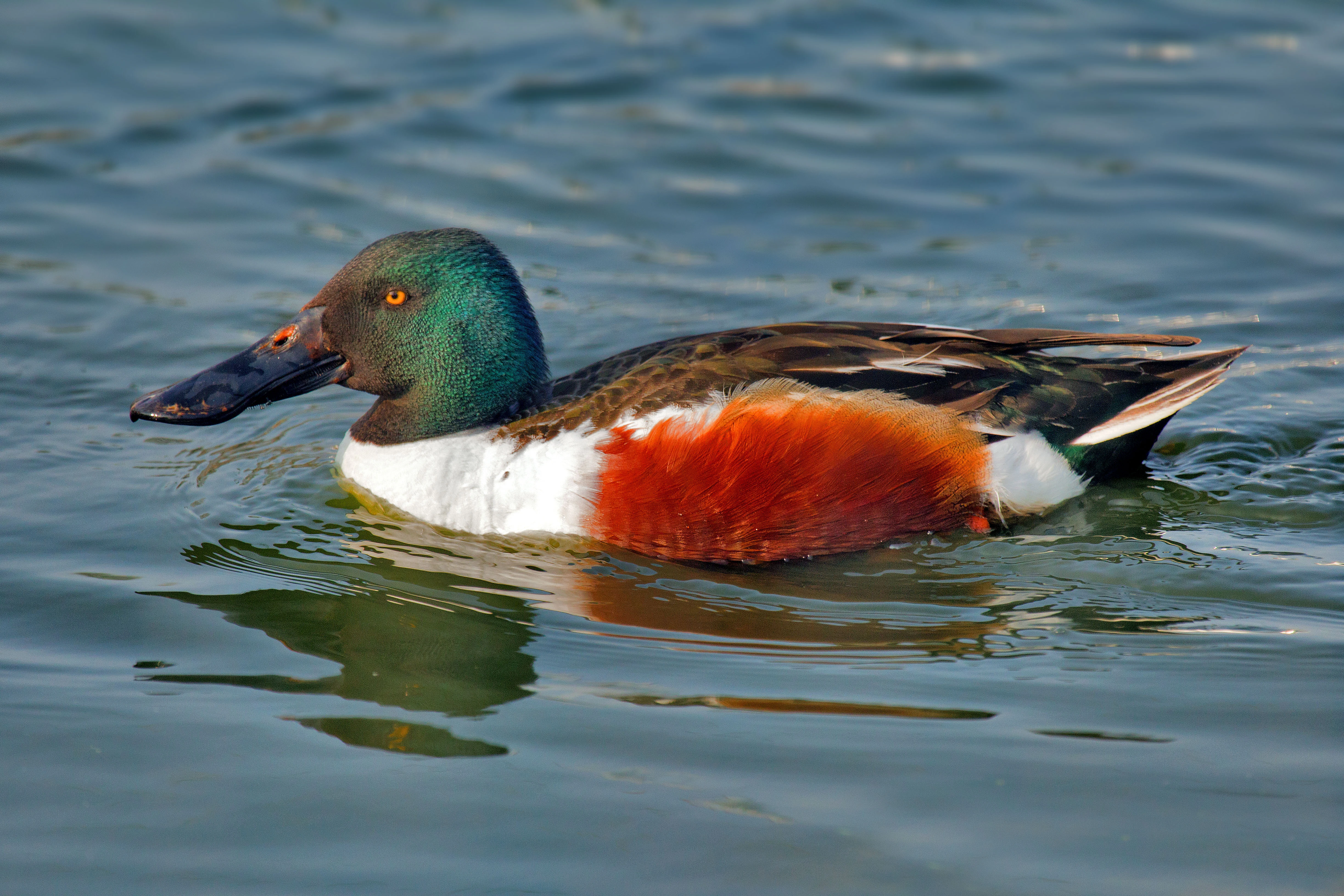
A male Northern Shoveler duck with a distinctive green head and rusty orange flank swimming on calm water.
A male Northern Shoveler swimming in the wetlands of Wagnonville Marsh.

Réserve naturelle régionale du marais de Wagnonville history and protected-area timeline

The hydrological history of the Wagnonville area goes back far beyond formal nature protection. The Escrebieux basin was once a vast alluvial wetland, a character still echoed in the name of Flers-en-Escrebieux, derived from the old word fleot, meaning water-covered terrain. In the nineteenth century, the marsh supported fish farming, with English monks establishing ponds that gave rise to the surviving local place name 'bois des Anglais'.

Throughout the twentieth century, the wetlands shrank steadily. Draining, drying, filling, and crop conversion reduced the once extensive marshes of the Escrebieux valley. In 1955 a landfill was established on the eastern edge of the Wagnonville marsh and expanded for several decades until its closure in the late 1980s. In 1960 the Escrebieux itself stopped flowing, as the creation and intensive use of drinking-water boreholes at Flers-en-Escrebieux, with annual extractions of around 18 million cubic meters by 1986, depressed the local water table and dried the river. Wagnonville thus became a rare surviving fragment of a much larger lost wetland network.

Recognition of the site's natural value emerged in 1990, when members of the GON (Groupement Ornithologique Naturel) carried out the first inventories, highlighted the ornithological interest of the marsh, and alerted the municipality of Douai. In 1994 this concern translated into formal protection with the creation of the Réserve naturelle volontaire du marais de Wagnonville. Following the 2002 'démocratie de proximité' law, which abolished all voluntary reserve classifications, the site was re-examined and, on 12 November 2007, was officially classified by the Nord-Pas-de-Calais regional council as a Réserve naturelle régionale, with the operational reference RNR23.

Réserve naturelle régionale du marais de Wagnonville landscape and geographic character

The physical shape of the Wagnonville reserve is small, low-lying, and unusually diverse for its size. Its southern and central portions belong to the floodplain ecology of the Escrebieux valley, with an étang, a scattering of smaller pools, drainage ditches, a soft muddy shore area, and the most unusual landform on the site, a sphagnum peat bog, set among surrounding wet ground.

A low hill breaks the otherwise flat profile of the reserve and supports an open habitat block, including a restored hygrophilous meadow and grass-dominated fallows that contrast visually with the wetter zones. Along the northern and western margins, woodlands soften the boundary with the surrounding urban and agricultural matrix, combining older park-like planting, recent poplar stands, acid-loving willow scrub, and denser shrub thickets. The result is a landscape of frequent contrasts, where open water, muddy ground, raised bog, meadow, and woodland stand within a few hundred meters of one another, all enclosed inside a dense peri-urban setting.
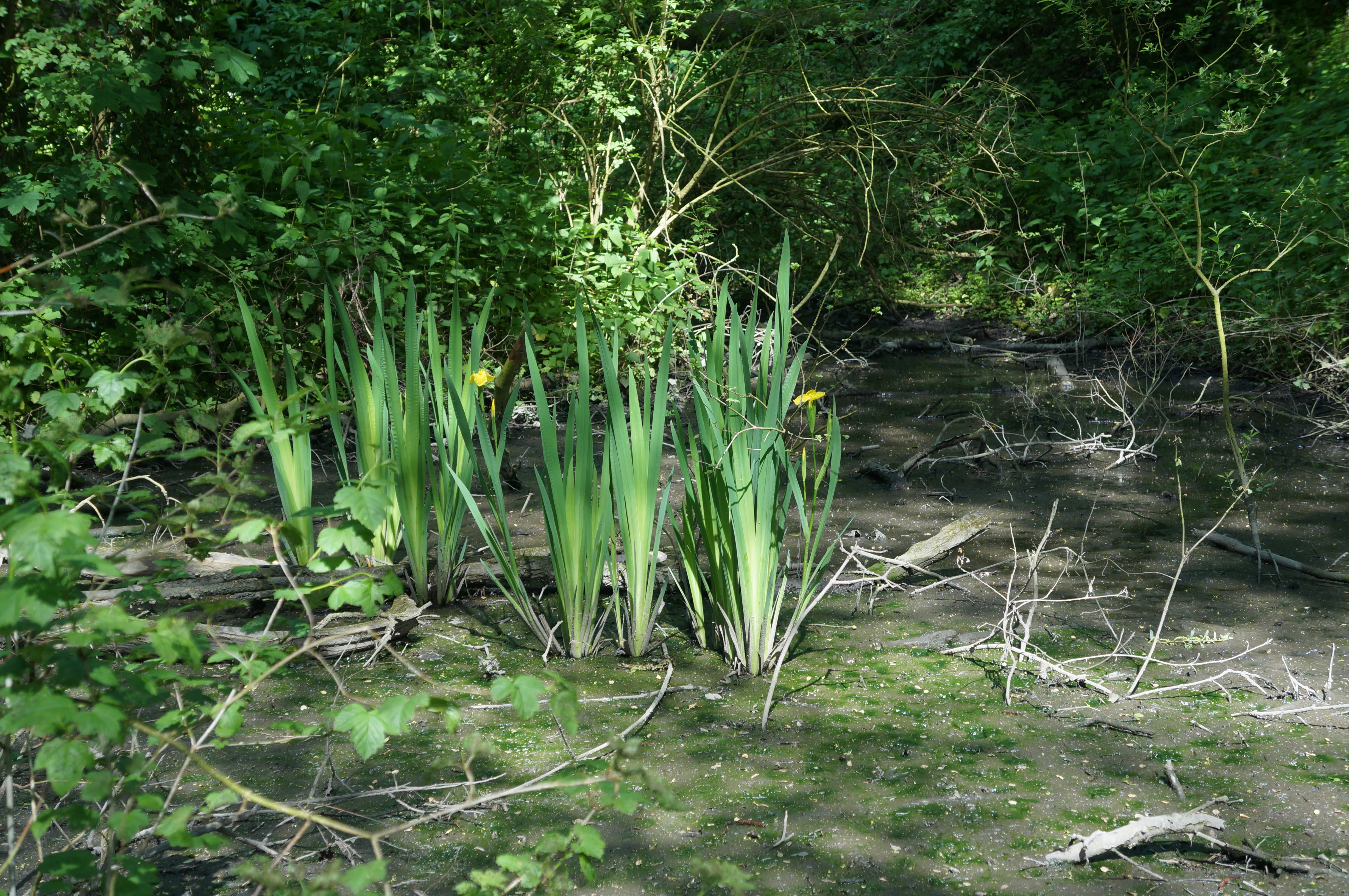
A cluster of yellow irises with tall green leaves growing in a muddy, shadowed wetland area backed by dense green foliage.
Yellow iris (Iris pseudacorus) blooming in the wetland habitat of Wagnonville Marsh Regional Nature Reserve.

Réserve naturelle régionale du marais de Wagnonville ecosystems, habitats, and plant life

Ecologically, the reserve is defined by its juxtaposition of wetland, woodland, and open-ground habitats within a very small area. The aquatic core is the most distinctive element: ponds and ditches fed by the local water table support emergent vegetation, while the sphagnum bog and associated muddy edge form a specialized micro-habitat that has no real equivalent left in the surrounding region.

The woodland component includes acidiphilous willow stands that thrive on the wetter, more acidic soils, mixed shrub formations, an older park-like wooded sector, and poplar plantations planted before the site's formal protection. The open habitats on the hill support hygrophilous meadow species and graminoid communities; the meadow has been actively restored, while the fallow areas reflect a more transitional character.

Botanical surveys in 2015 identified around 220 plant species across these zones. At least three are considered patrimonial for the region: the marsh willowherb Epilobium palustre, found in wet meadows and the bog; Rorippa palustris, growing in marshy conditions; and Sphagnum russowii, whose tiny bog station is the only known occurrence of this moss in northern France, alongside four other sphagnum species also recorded in the peat bog. The marsh also supports the locally uncommon Hippuris vulgaris, sometimes called mare's tail or aquatic bread, which has become rare across much of its natural range. The site is, however, also affected by invasive plants, including Japanese knotweed, Sakhalin knotweed, smooth goldenrod, and black locust, all of which are monitored as ongoing management concerns.

Réserve naturelle régionale du marais de Wagnonville wildlife and species highlights

The animal life of the Wagnonville marsh mirrors the diversity of its habitats. Around 140 animal species have been recorded on or around the 20-hectare site, with birds forming the most conspicuous element: 87 bird species overall, including waterfowl and wetland raptors that find refuge in the ponds, ditches, and reed-fringed bog.

The most easily observed species are visible waterbirds such as the northern shoveler and the grey heron, which use the open water and muddy edges. Four species have regional heritage value: the reed grasshopper Conocephalus dorsalis, the common pochard, the whiskered bat Myotis mystacinus, and the marsh harrier, a wetland raptor especially dependent on the reed and sedge habitats the reserve protects.

Mammal records include eight species, with bat presence confirmed through the whiskered bat record. Five amphibian and reptile species complete the vertebrate list. The invertebrate fauna is also substantial for such a small reserve, with 19 butterfly species, 7 grasshopper and cricket species, and 12 dragonfly and damselfly species documented, the latter reflecting the quality of the standing water and bog habitats that the site continues to support within an otherwise heavily urbanized landscape.

Réserve naturelle régionale du marais de Wagnonville conservation status and protection priorities

From a conservation perspective, the Wagnonville reserve matters because it preserves, in a small envelope, a habitat type that has otherwise almost disappeared from its region. The Escrebieux valley once held an extensive alluvial wetland, but successive waves of drainage, agricultural conversion, landfill expansion, and groundwater extraction reduced it to scattered fragments; the Wagnonville marsh is now one of the very last of these fragments and effectively serves as a reference site for the lost Escrebieux wetlands.

Its designation reflects a layered legal and institutional effort. National recognition came first through a voluntary reserve in 1994, and regional recognition followed in 2007 after the voluntary designation framework was reformed. IUCN protection is registered as Category IV, recognizing the site as a habitat and species management area. The Conservatoire d'espaces naturels du Nord et du Pas-de-Calais and the Commune of Douai share management responsibilities, with detailed management plans guiding habitat restoration, invasive species control, and long-term monitoring of flora, fauna, and habitats.

Equally important is the conservation work focused on the bog itself, which shelters the only known population of Sphagnum russowii in northern France and which therefore has an interest well beyond regional boundaries. Active management of hygrophilous meadows, control of invasive knotweeds and goldenrod, and ongoing faunal and floral inventories sustain the site's ability to function as a refuge for wetland species in a heavily modified peri-urban environment.

Réserve naturelle régionale du marais de Wagnonville cultural meaning and human context

The cultural context of the reserve is woven into the older landscape rather than into recent human activity. The Escrebieux basin is associated with medieval and early modern land use, and the nineteenth-century fish ponds dug by English monks explain the persistence of the local place name 'bois des Anglais' within the protected area, a small linguistic trace of the site's pisciculture past.

The town's name Flers-en-Escrebieux preserves a more ancient layer of meaning: the toponym fleot, meaning water-covered ground, reflects how dominant wetland once was in the local identity. Today, the reservoir's cultural role is more contemporary, linked to environmental awareness and education, with guided visits allowing local residents, school groups, and naturalists to engage with a piece of living wetland history surrounded by the dense and heavily industrialized Hauts-de-France urban fabric.

Top sights and standout views in Réserve naturelle régionale du marais de Wagnonville

Among the strongest distinguishing traits of the reserve is its peat bog, only 20 hectares in total yet hosting the only known station of Sphagnum russowii in northern France. Equally notable is the site's densely packed habitat mosaic, in which ponds, ditches, sphagnum bog, willow woodland, poplar plantation, and restored hygrophilous meadow coexist within walking distance of Douai's center. The reserve is also remarkable as a recovery story, achieved despite the loss of the Escrebieux river and the legacy of a long-running landfill on its eastern edge, both of which shaped its twentieth-century history.

Best time to visit Réserve naturelle régionale du marais de Wagnonville

The Wagnonville reserve is most rewarding in late spring and early summer, when sphagnum bog vegetation, marsh plants such as marsh willowherb, and restored hygrophilous meadows are at their most visible, and when dragonflies, damselflies, and wetland birds are most active around the ponds and ditches. Migratory and breeding waterbirds are also typically easier to observe during this window. Because access is limited to guided visits, visitors generally experience the site as a quiet, structured outing rather than a freely walked landscape; late spring through summer highlights the bog and meadow flora, while visits in late autumn or winter can offer a calmer atmosphere and good viewing conditions for overwintering waterfowl. Detailed seasonal access is best confirmed through the Conservatoire d'espaces naturels du Nord et du Pas-de-Calais, which organizes public events on the site.


Monthly climate preview

Long term temperature and precipitation records measured at a representative coordinate

Réserve naturelle régionale du marais de Wagnonville Climate Normals and Weather by Month

Representative coordinate records show average temperatures ranging from sub-zero winter minimums to warm summer highs alongside steady monthly precipitation throughout the year. Examining the full twelve-month profile provides complete historical climate data for analyzing annual environmental rhythms.
Annual mean10 °C
3 °C18 °C
Jan
Feb
Mar
Apr
May13°
Jun16°
Jul18°
Aug18°
Sep15°
Oct11°
Nov
Dec
Warmest month
July

18 °C

Coolest month
January

2.9 °C

Wettest month
December

2.5 mm/day

Driest month
April

1.5 mm/day

Park location guide

Geography guide, regional context, and park location map for Réserve naturelle régionale du marais de Wagnonville

Réserve naturelle régionale du marais de Wagnonville park geography, regions, and map view in France

Understand where Réserve naturelle régionale du marais de Wagnonville sits in France through a broader geographic reading of the surrounding landscape, nearby location context, and its mapped position within the national park landscape.

How Réserve naturelle régionale du marais de Wagnonville fits into France

France is a unitary semi-presidential republic and one of the world's largest economies. It borders Belgium, Luxembourg, Germany, Switzerland, Italy, Monaco, Andorra, and Spain, with a maritime border to the United Kingdom. The country is known for its cultural influence, art, cuisine, and political history spanning centuries.

Wider geography shaping Réserve naturelle régionale du marais de Wagnonville in France

France is located in Western Europe. Metropolitan France extends from the Rhine to the Atlantic Ocean and from the Mediterranean Sea to the English Channel and North Sea. The country borders Belgium, Luxembourg, Germany, Switzerland, Italy, Monaco, Andorra, Spain, and has a maritime border with the United Kingdom.

Map view of Réserve naturelle régionale du marais de Wagnonville

Use this park location map to pinpoint Réserve naturelle régionale du marais de Wagnonville in France, understand its exact geographic position, and read its mapped placement within the surrounding landscape more clearly.

Pigeon | © OpenStreetMap contributors

Location context for Réserve naturelle régionale du marais de Wagnonville

Hauts-de-France

Visualizing wetland habitats, peat bogs, and protected marsh terrain

Réserve naturelle régionale du marais de Wagnonville Photos and Landscape Scenery

Visual records reveal the diverse mosaic of ponds, willow woodlands, and rare sphagnum peat bogs defining the protected wetland. Detailed photography highlights the unique terrain and ecological contrast preserved within a densely urbanized northern French landscape.

A male Northern Shoveler duck with a distinctive green head and rusty orange flank swimming on calm water.

A close-up of a pale pink, four-petaled flower with delicate veins and a prominent central stamen, set against a blurred blue and green background.

A cluster of yellow irises with tall green leaves growing in a muddy, shadowed wetland area backed by dense green foliage.

Park atlas

Compare adjacent wetland habitats, regional nature reserves, and connected northern French landscapes.

Parks Near Réserve Naturelle Régionale du Marais de Wagnonville and Surrounding Protected Areas

Browsing protected areas near Réserve naturelle régionale du marais de Wagnonville reveals a wider network of alluvial valleys and lowland marshes. Examining adjacent regional reserves provides valuable context on periurban conservation challenges and surviving wetland ecosystems.
Nature reserveHauts-de-France
About 2.5 km away#1 closest

Northeast

Réserve naturelle régionale des Annelles, Lains et Pont Pinnet: Protected Landscape Geography

A unique biodiversity refuge in the Hauts-de-France region of France.

The Réserve naturelle régionale des Annelles, Lains et Pont Pinnet showcases a dense patchwork of 26 natural habitats across a 14-hectare expanse. Its mapped boundaries reveal a mosaic of wet marshes, coal-shale terrils, and peat-forming ecosystems that support a significant variety of amphibians, dragonflies, and metallophyte flora. This protected area offers a clear look at how industrial landscapes can transition into essential botanical refuges within the northern French coal basin.

Area
0.146 km²
Established
2010
IUCN
IV
Relief
Lowland
Protected areaNord
About 3.7 km away#2 closest

East

Vallées de la Scarpe et de l'Escaut Protected Landscape Geography and Map Context

Wetland mosaic, subsidence lakes, and river floodplains in Nord

Examine the physical geography of the Scarpe and Escaut Valleys, a premier wetland site in northern France. The protected area features a mosaic of marshes, wet meadows, and mining-subsidence lakes that provide vital habitats for migratory waterbirds and support carbon storage through rare alkaline peatlands.

Area
276.22 km²
Established
2020
Relief
Lowland
Scope
Terrestrial
A panoramic watercolor painting showing a winding river in a green meadow, with a line of trees on the right and purple mountains in the background.
Nature reserveHauts-de-France
About 12 km away#3 closest

East

Réserve naturelle régionale de la tourbière de Vred: Protected Peatbog and Wetland Map

Geographic landscape in the Hauts-de-France alluvial plain

Vred Peatbog is an ecologically significant protected site in northern France, known for its floating sphagnum-bearing peat formation. The reserve contains a mosaic of managed drainage channels, reedbeds, and woodlands that provide a critical sanctuary for wetland species within the Scarpe valley landscape. This mapping data provides a detailed look at the site's unique alluvial basin and regional conservation status.

Area
0.41 km²
Established
2008
IUCN
IV
Relief
Lowland
Watercolor painting of a soft, hazy landscape featuring low hills in the background and marshy wetlands in the foreground with pastel shades of green, yellow, and soft pink.
Nature reserveHauts-de-France
About 14 km away#4 closest

East

Réserve naturelle régionale du pré des Nonnettes: Regional Nature Reserve and Wetland Atlas

Alluvial marshland and hay meadow terrain in the Hauts-de-France

The Réserve naturelle régionale du pré des Nonnettes preserves a rare wet hay meadow habitat within the Marais du Vivier. Located in the lower Scarpe river valley, this nature reserve integrates marshy ground, ponds, and riparian woods to support a concentrated mosaic of wetland biodiversity. MoriAtlas provides detailed geographic context for this protected site and its significance within the larger Hauts-de-France wetland conservation network.

Area
0.173 km²
Established
2008
IUCN
IV
Relief
Lowland
Watercolor painting of a marshy wetland landscape featuring rolling hills, green trees, and foreground grasses against a white background.
Nature reservePas-de-Calais
About 27 km away#5 closest

Northwest

Marais de Cambrin, Annequin, Cuinchy et Festubert Regional Nature Reserve: Protected Wetland Atlas

Alluvial floodplains and biodiversity refuges in Pas-de-Calais

Trace the boundaries and protected features of the Marais de Cambrin, Annequin, Cuinchy et Festubert Regional Nature Reserve. This site preserves an essential mosaic of open water, peat-rich fens, and damp alluvial woods that function as a crucial nesting ground for waterfowl and a repository for rare botanical heritage in northern France.

Area
0.742 km²
Established
2009
IUCN
IV
Relief
Lowland
A watercolor illustration of a natural reserve landscape featuring foreground shrubs and grasses with a distant treeline, set against a plain white background.
Nature reserveHauts-de-France
About 27 km away#6 closest

North

Réserve naturelle régionale du Héron: Wetland and Birding Landscape in Hauts-de-France

Periurban protected area near Lille.

Located in the Hauts-de-France region, Réserve naturelle régionale du Héron serves as an important ornithological site centered on the Lac du Héron. The protected boundaries encompass a diverse terrain of wetlands, reed-fringed margins, and woodland that support significant migratory avian populations within an urban-adjacent setting.

Area
0.732 km²
Established
2012
IUCN
IV
Relief
Lowland
A soft, painterly watercolor illustration showing a winding river flowing through a lush green valley with rolling hills in the background.
Nature reserveHauts-de-France
About 27 km away#7 closest

South

Réserve naturelle régionale de l'Escaut-rivière: Protected Wetland and Alluvial Corridor

Regional nature reserve in the Hauts-de-France floodplain

Spanning sixty hectares in the Cambrésis plain, this reserve protects a unique alluvial floodplain mosaic. The site provides a critical habitat refuge of wet meadows and regenerating woodland, marking a significant success in ecological restoration and fluvial corridor protection along the Escaut river.

Area
0.594 km²
Established
2011
IUCN
IV
Relief
Lowland
A soft watercolor painting showing a panoramic landscape with light green trees and low hills in the background, set against a pale, washed-out sky.
Nature reserveHauts-de-France
About 37 km away#8 closest

Northwest

Réserve naturelle régionale des prés du Moulin Madame: Regional Protected Meadow Map

Riverine floodplain landscapes in the Hauts-de-France region

The Réserve naturelle régionale des prés du Moulin Madame protects an 8.52 hectare corridor along the Lys river. This site highlights the preservation of traditional flood meadows that are increasingly rare in northern France. Users can examine the park boundaries, understand the flat lowland terrain, and trace the riverine geography that defines this unique protected cultural landscape.

Area
0.085 km²
Established
2015
IUCN
IV

Common questions about visiting, size, designation, and location context for Réserve naturelle régionale du marais de Wagnonville

Réserve naturelle régionale du marais de Wagnonville FAQs for park facts, access, geography, and protected area context

Find quick answers about Réserve naturelle régionale du marais de Wagnonville, including protected-area facts, park geography, trail and visitor context, and how the park fits into its surrounding country and regional landscape.
MoriAtlas Explorer

Continue Your Protected Areas Search Across the Global Atlas

Deepen your exploration by continuing the structured search for national parks and protected areas worldwide. Utilize the comprehensive filtering capabilities to compare different conservation landscapes and refine your understanding of global park geography. Discover more about the distribution and characteristics of protected natural areas.

Global natural geography