

Mori Atlas logo
Nature reserveRéserve naturelle régionale des prés du Moulin Madame

Mapping the cultural history and floodplain geography of the historic Lys river valley

Réserve naturelle régionale des prés du Moulin Madame: Protected Wetland and River Landscapes

Réserve naturelle régionale des prés du Moulin Madame preserves a rare expanse of wet meadows, known as prés de fauche, within the lowland Lys valley of northern France. This regional nature reserve serves as an ecologically valuable mosaic of riverine habitats shaped by centuries of traditional meadow management. The site demonstrates the intersection of historical linen-bleaching industry and modern conservation, providing a distinct geographic perspective on protected land within the densely settled Hauts-de-France region.

regional nature reservewet meadowsfloodplainriverine habitatLys valleyhay meadows
A digital illustration depicting a sunny mountain landscape with a waterfall feeding into a river, surrounded by pine forests and cliffs under a soft-colored sky.

Réserve naturelle régionale des prés du Moulin Madame

Nature reserve

Park overview

Structured park overview, official facts, and landscape profile for Réserve naturelle régionale des prés du Moulin Madame

Réserve naturelle régionale des prés du Moulin Madame park facts, protected area profile, and essential visitor context

Review the core facts for Réserve naturelle régionale des prés du Moulin Madame, including designation, size, terrain, visitor scale, habitats, and operating context in one park-focused overview.

About Réserve naturelle régionale des prés du Moulin Madame

The Réserve naturelle régionale des prés du Moulin Madame is a small but ecologically meaningful regional nature reserve set along the banks of the Lys river in the Pas-de-Calais department of northern France. Covering roughly 8.52 hectares, it represents one of the many modest yet targeted nature reserves that make up the French regional protection network, designed to safeguard specific habitats of regional importance.

The reserve sits within the Hauts-de-France region, on the territory of the commune of Sailly-sur-la-Lys, and forms part of a broader landscape shaped by the Lys valley and its historic relationship with the textile industry. The site preserves a fragment of the prés de fauche, traditional wet meadows that were once central to a flourishing linen bleaching economy. These meadows were managed through regular mowing, allowing a rich flora to develop over centuries of consistent, low-intensity agricultural use.

Although the reserve is small in area, its ecological value lies in the preservation of habitat types that have largely disappeared elsewhere in northern France. As a Category IV protected area under the IUCN framework, it is classified specifically for habitat and species management, indicating that its principal role is to maintain and restore riverine meadow ecosystems rather than to provide strict wilderness protection. The reserve is administered by the Conservatoire d'espaces naturels du Nord et du Pas-de-Calais, a regional conservation body with broad experience in managing small protected natural sites across northern France.

Beyond its conservation role, the site also functions as a local amenity. A discovery trail runs along the river and through the flowering wet meadows, with interpretive panels explaining the history, flora, and cultural heritage of the area. This combination of ecological preservation and public engagement is a defining feature of many regional nature reserves in France, which serve both biodiversity protection and environmental education goals.

Quick facts and research context for Réserve naturelle régionale des prés du Moulin Madame

The Réserve naturelle régionale des prés du Moulin Madame lies in the Hauts-de-France region, in the Pas-de-Calais department, on the territory of the commune of Sailly-sur-la-Lys. It sits beside the Lys river, a tributary of the Scheldt, and forms a typical example of a lowland river valley protected site.

Classified on 16 February 2015 by a decision of the Regional Council, the reserve covers around 8.52 hectares and is managed by the Conservatoire d'espaces naturels du Nord et du Pas-de-Calais. It carries the designation RNR283 and falls under IUCN Category IV, meaning it is managed primarily for the conservation of habitats and species. The reserve is officially listed in international databases, including the World Database on Protected Areas.

Protection and recognition

Documented conservation status and protected area designation records

Réserve Naturelle Régionale des Prés du Moulin Madame Protection Status

Protected area records for Réserve naturelle régionale des prés du Moulin Madame compile verified management scope and official designation data. Conservation status details and international recognition metrics offer reliable context for ecological research.

Protection details

WDPA ID
555597272
Park context

Deeper park guide and search-rich context for Réserve naturelle régionale des prés du Moulin Madame

Réserve naturelle régionale des prés du Moulin Madame history, landscape, wildlife, and travel context

Explore Réserve naturelle régionale des prés du Moulin Madame through its history, landscape character, ecosystems, wildlife, conservation priorities, cultural context, and seasonal travel timing in a structured park guide built for atlas discovery and search intent.

Why Réserve naturelle régionale des prés du Moulin Madame stands out

The reserve is best known for preserving a stretch of wet meadows, or prés de fauche, along the Lys river. These traditional hay meadows, once used for spreading and bleaching linen cloth during the 19th century, are ecologically valuable as flower-rich floodplain grasslands that have become increasingly rare in intensively farmed northern France.
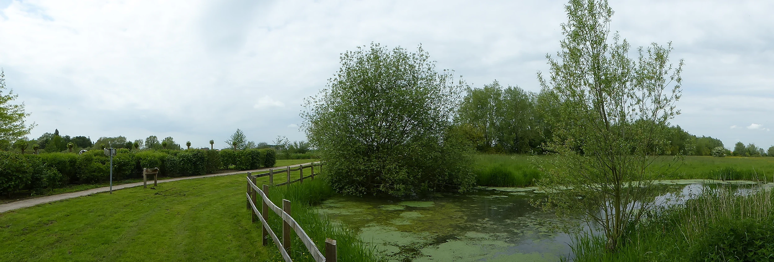
A panoramic landscape view showing a grassy meadow, a small pond with surface vegetation, and a wooden fence bordering a path in a nature reserve under a cloudy sky.
A view of the wet meadows and canalized water at Réserve naturelle régionale des prés du Moulin Madame.

Réserve naturelle régionale des prés du Moulin Madame history and protected-area timeline

The wet meadows along the Lys river that now make up the reserve have a long cultural history tied to the textile industry. In the 19th century, this section of the Lys valley was a thriving center for linen bleaching, where large expanses of meadow, known as prés de fauche, were used to spread and bleach woven cloth laid out on the grass. The practice of bleaching linen in open meadows required vast, well-maintained grasslands, and the resulting low-intensity mowing regime is what preserved the botanical richness of these floodplain meadows over time.

While the industrial bleaching activity eventually declined and disappeared, the meadows that supported it survived in the landscape. Their recognition as a site of regional ecological importance came in the early 21st century, when conservation bodies in the Hauts-de-France region identified them as a valuable refuge for traditional meadow habitats under pressure from modern agriculture and urban development.

The reserve itself was formally established on 16 February 2015, when the Regional Council adopted the classification decision creating the Réserve naturelle régionale des prés du Moulin Madame. From the outset, management of the site was entrusted to the Conservatoire d'espaces naturels du Nord et du Pas-de-Calais, the regional conservation agency responsible for managing many small protected natural areas in northern France. The reserve's establishment reflects a broader French pattern of designating modest, focused regional reserves to protect fragments of culturally and ecologically significant landscapes that might otherwise be lost to land-use change.

Réserve naturelle régionale des prés du Moulin Madame landscape and geographic character

The landscape of the reserve is defined by the Lys river valley, a lowland watercourse in northern France that flows north toward the Scheldt. The protected area consists of a narrow corridor of wet meadows and riparian habitats fringing the river, set within an otherwise heavily modified agricultural and built-up region. The terrain is flat, with slight variations in elevation shaped by the river channel and seasonal flooding patterns.

The most prominent landscape feature is the expanse of prés de fauche themselves, which are open, regularly mown meadows that lie alongside the Lys. These grasslands are periodically influenced by river flooding and groundwater levels, giving them their characteristic wet-meadow character. The riverbank environment includes varying transitions between water, wet soil, and herbaceous vegetation, producing a small but varied mosaic of habitats within a compact area.

Although the visual character of the site is modest, its landscape holds cultural depth, reflecting the long interaction between human activity and the river valley. The route of the discovery trail follows the river's edge, allowing visitors to experience the open meadow panorama that has characterized this stretch of the Lys for centuries.

Réserve naturelle régionale des prés du Moulin Madame ecosystems, habitats, and plant life

The ecological focus of the reserve is the preservation of lowland riverine meadow habitats, particularly traditional flood meadows that have been maintained through long-term mowing rather than intensive agriculture. Such habitats are characterized by a diverse herbaceous flora and a close relationship with the river's hydrology, including seasonal flooding cycles.

The Lys river corridor provides an important ecological function at the local scale, supporting wetland vegetation along its banks and offering a habitat mosaic that contrasts with the surrounding agricultural land. Given the reserve's small size, its ecological value lies less in extensive habitat blocks and more in maintaining a high-quality example of a habitat type that is increasingly rare across the plains of northern France.

As a regional nature reserve, the site is intended to demonstrate how targeted protection of small habitat fragments, when integrated within broader landscape management, can contribute meaningfully to regional biodiversity conservation.

Réserve naturelle régionale des prés du Moulin Madame conservation status and protection priorities

The reserve's conservation purpose centers on the protection of riverine wet meadows that form part of the regional natural heritage of the Hauts-de-France region. Classified as an IUCN Category IV protected area, the site is managed primarily for the conservation of habitats and species, with attention to maintaining the conditions that support meadow biodiversity, including appropriate mowing regimes and the protection of the riparian zone along the Lys.

The reserve is managed by the Conservatoire d'espaces naturels du Nord et du Pas-de-Calais, an experienced regional conservation organization with a portfolio of similar sites across northern France. Its designation in 2015 added the prés du Moulin Madame to a wider network of French regional nature reserves that act as small, focused conservation areas embedded in working landscapes.

Although small, the reserve contributes to broader conservation objectives in the region by preserving an example of a threatened habitat type in a part of France where intensive agriculture, urbanization, and industrial legacies have significantly reduced the presence of traditional meadows. It also functions as a demonstration site for the long-term relationship between cultural heritage and ecological value, illustrating how centuries of low-intensity land use can produce biodiversity-rich habitats worth preserving.

Réserve naturelle régionale des prés du Moulin Madame cultural meaning and human context

The cultural identity of the site is closely tied to the historic textile industry of the Lys valley. In the 19th century, this stretch of the river was associated with linen bleaching operations that relied on large areas of well-maintained meadow to spread and whiten woven cloth. These industries, along with local mills such as the Moulin Madame that gives the reserve its name, shaped the economic life of communes along the river, including Sailly-sur-la-Lys.

Although the bleaching industry has long disappeared, its legacy persists in the surviving meadows, whose botanical richness is itself a product of centuries of low-intensity traditional management. The reserve therefore carries a layered cultural significance, linking industrial heritage, traditional agricultural practice, and the modern culture of nature conservation in one site. Interpretive elements along the discovery trail highlight this intertwined history, helping visitors understand how a working industrial landscape gave rise to a habitat now valued for its ecological character.

Top sights and standout views in Réserve naturelle régionale des prés du Moulin Madame

Among the strongest distinguishing features of the reserve is the combination of a small, high-quality wet meadow habitat with a deeply rooted cultural history tied to linen bleaching. Few protected sites elsewhere combine such a clear narrative connection between 19th-century industry and contemporary biodiversity conservation.

Its setting along the Lys river, in a heavily populated region of northern France, gives it value as a representative example of lowland riverine meadow conservation in a constrained landscape context. The presence of an accessible discovery trail with interpretive panels further distinguishes the reserve as a site where ecological protection and public education intersect on a small but meaningful scale.

Best time to visit Réserve naturelle régionale des prés du Moulin Madame

The reserve is best experienced during the warmer months when the wet meadows are in active growth and flowering, typically from late spring through summer. During this period, the herbaceous vegetation of the prés de fauche reaches its richest expression, and atmospheric conditions along the Lys river tend to be most comfortable for walking the discovery trail.

Visiting outside the peak growing season offers a quieter experience and a clearer view of the river corridor itself, though the floral character of the meadows is largely reduced in cooler months. As a small lowland site, the reserve does not depend on alpine or high-elevation seasonal effects, and its general character is shaped more by the rhythm of meadow management and river hydrology than by dramatic seasonal swings in weather.

Monthly climate preview

Long term temperature and precipitation normals for the representative park coordinate

Réserve naturelle régionale des prés du Moulin Madame Climate and Weather by Month

Measured temperature and precipitation data for Réserve naturelle régionale des prés du Moulin Madame reveal a consistent annual rhythm across all twelve recorded months. Examining the complete monthly climate profile provides deeper context for long term atmospheric patterns at the representative elevation.
Annual mean10 °C
3 °C18 °C
Jan
Feb
Mar
Apr
May13°
Jun15°
Jul18°
Aug17°
Sep15°
Oct11°
Nov
Dec
Warmest month
July

17.5 °C

Coolest month
January

3.1 °C

Wettest month
November

2.6 mm/day

Driest month
April

1.5 mm/day

Park location guide

Geography guide, regional context, and park location map for Réserve naturelle régionale des prés du Moulin Madame

Réserve naturelle régionale des prés du Moulin Madame park geography, regions, and map view in France

Understand where Réserve naturelle régionale des prés du Moulin Madame sits in France through a broader geographic reading of the surrounding landscape, nearby location context, and its mapped position within the national park landscape.

How Réserve naturelle régionale des prés du Moulin Madame fits into France

France is a unitary semi-presidential republic and one of the world's largest economies. It borders Belgium, Luxembourg, Germany, Switzerland, Italy, Monaco, Andorra, and Spain, with a maritime border to the United Kingdom. The country is known for its cultural influence, art, cuisine, and political history spanning centuries.

Wider geography shaping Réserve naturelle régionale des prés du Moulin Madame in France

France is located in Western Europe. Metropolitan France extends from the Rhine to the Atlantic Ocean and from the Mediterranean Sea to the English Channel and North Sea. The country borders Belgium, Luxembourg, Germany, Switzerland, Italy, Monaco, Andorra, Spain, and has a maritime border with the United Kingdom.

Map view of Réserve naturelle régionale des prés du Moulin Madame

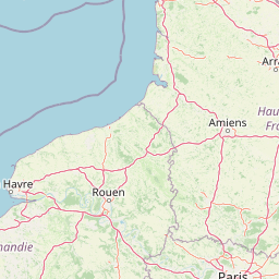
Use this park location map to pinpoint Réserve naturelle régionale des prés du Moulin Madame in France, understand its exact geographic position, and read its mapped placement within the surrounding landscape more clearly.

Pigeon | © OpenStreetMap contributors

Location context for Réserve naturelle régionale des prés du Moulin Madame

Hauts-de-France

Examine floodplain terrain, wet meadow habitats, and riverine scenery along the Lys valley.

Visual Explorer and Landscape Photos of Réserve naturelle régionale des prés du Moulin Madame

Visual records capture the open hay meadows and riparian corridors that define the protected landscape along the Lys river. Photographic documentation illustrates the wetland terrain and floodplain habitats preserved within northern France.

A panoramic landscape view showing a grassy meadow, a small pond with surface vegetation, and a wooden fence bordering a path in a nature reserve under a cloudy sky.

A small pond covered in green algae sits in the foreground with lush green grass and trees extending into the background under an overcast sky.

Park atlas

Compare adjacent river valley reserves and connected lowland floodplain habitats across northern France.

Parks Near Réserve Naturelle Régionale Des Prés Du Moulin Madame And Regional Protected Areas

Browsing other protected areas near Réserve naturelle régionale des prés du Moulin Madame reveals a wider network of lowland riverine wetlands and historic flood meadows. Comparing these regional nature reserves offers valuable geographical context into northern France conservation landscapes.
Watercolor painting of a marshy wetland landscape featuring rolling hills, green trees, and foreground grasses against a white background.
Nature reservePas-de-Calais
About 15 km away#1 closest

South

Marais de Cambrin, Annequin, Cuinchy et Festubert Regional Nature Reserve: Protected Wetland Atlas

Alluvial floodplains and biodiversity refuges in Pas-de-Calais

Trace the boundaries and protected features of the Marais de Cambrin, Annequin, Cuinchy et Festubert Regional Nature Reserve. This site preserves an essential mosaic of open water, peat-rich fens, and damp alluvial woods that function as a crucial nesting ground for waterfowl and a repository for rare botanical heritage in northern France.

Area
0.742 km²
Established
2009
IUCN
IV
Relief
Lowland
A watercolor illustration of a natural reserve landscape featuring foreground shrubs and grasses with a distant treeline, set against a plain white background.
Nature reserveHauts-de-France
About 28 km away#2 closest

East

Réserve naturelle régionale du Héron: Wetland and Birding Landscape in Hauts-de-France

Periurban protected area near Lille.

Located in the Hauts-de-France region, Réserve naturelle régionale du Héron serves as an important ornithological site centered on the Lac du Héron. The protected boundaries encompass a diverse terrain of wetlands, reed-fringed margins, and woodland that support significant migratory avian populations within an urban-adjacent setting.

Area
0.732 km²
Established
2012
IUCN
IV
Relief
Lowland
Nature reserveHauts-de-France
About 29 km away#3 closest

West

Réserve naturelle régionale du plateau des landes: Regional Nature Reserve Landscape Profile

Protected heathland geography in the Pas-de-Calais corridor.

Understand the ecological structure of the Réserve naturelle régionale du plateau des landes. This protected area features a unique crescent shape and mosaic of heathland sectors spread across several communes, offering a focused study of low-elevation inland conservation management in the heart of northern France.

Area
1.811 km²
Established
2009
IUCN
IV
A horizontal watercolor illustration depicting a soft, impressionistic landscape of wetland meadows, grassy patches, and distant trees in pastel shades of green, yellow, and soft purple.
Nature reserveHauts-de-France
About 30 km away#4 closest

Northwest

Réserve naturelle régionale du vallon de la Petite Becque: Protected Area Map and Geography

Flemish Houtland wetland conservation and regional green infrastructure

This protected area in Hauts-de-France functions as a compact, high-value laboratory for habitat restoration within the modernized Flemish countryside. It provides essential sanctuary for relict marsh flora, orchid-rich meadows, and specialized invertebrate communities, effectively acting as an ecological island amidst a vast expanse of intensively cultivated arable farmland.

Area
0.009 km²
Established
2010
IUCN
IV
Relief
Lowland
A soft watercolor painting of a green meadow, featuring gentle hills in the distance, a small stream flowing through the center, and a few scattered trees, all set against a white background.
Nature reserveHauts-de-France
About 33 km away#5 closest

Northwest

Réserve naturelle régionale des prairies du Schoubrouck: Geography and Protected Area Overview

Wet-meadow habitats and historic watergang networks in northern France.

Located in the Hauts-de-France region, Réserve naturelle régionale des prairies du Schoubrouck provides a focused look at the cultural and ecological heritage of Flemish lowland landscapes. This site preserves an essential mosaic of wet grasslands and traditional drainage systems, serving as a key example of habitat-specific conservation stewardship within the rural fabric of the Nord department.

Area
0.102 km²
Established
2012
IUCN
IV
Nature reserveHauts-de-France
About 36 km away#6 closest

Southeast

Réserve naturelle régionale des Annelles, Lains et Pont Pinnet: Protected Landscape Geography

A unique biodiversity refuge in the Hauts-de-France region of France.

The Réserve naturelle régionale des Annelles, Lains et Pont Pinnet showcases a dense patchwork of 26 natural habitats across a 14-hectare expanse. Its mapped boundaries reveal a mosaic of wet marshes, coal-shale terrils, and peat-forming ecosystems that support a significant variety of amphibians, dragonflies, and metallophyte flora. This protected area offers a clear look at how industrial landscapes can transition into essential botanical refuges within the northern French coal basin.

Area
0.146 km²
Established
2010
IUCN
IV
Relief
Lowland
Nature reserveHauts-de-France
About 37 km away#7 closest

Southeast

Réserve naturelle régionale du marais de Wagnonville: Protected Wetland and Bog Geography

A resilient marshland ecosystem in the Douai urban landscape.

This reserve provides a comprehensive look at the surviving wetlands of the Escrebieux valley. Covering 20 hectares, the area hosts a dense variety of habitats from open ponds to rare sphagnum peat bogs, marking an essential node of biodiversity and ecological restoration within the northern French administrative landscape.

Area
0.2 km²
Established
1994
IUCN
IV
Relief
Lowland
Protected areaNord
About 37 km away#8 closest

Southeast

Vallées de la Scarpe et de l'Escaut Protected Landscape Geography and Map Context

Wetland mosaic, subsidence lakes, and river floodplains in Nord

Examine the physical geography of the Scarpe and Escaut Valleys, a premier wetland site in northern France. The protected area features a mosaic of marshes, wet meadows, and mining-subsidence lakes that provide vital habitats for migratory waterbirds and support carbon storage through rare alkaline peatlands.

Area
276.22 km²
Established
2020
Relief
Lowland
Scope
Terrestrial

Common questions about visiting, size, designation, and location context for Réserve naturelle régionale des prés du Moulin Madame

Réserve naturelle régionale des prés du Moulin Madame FAQs for park facts, access, geography, and protected area context

Find quick answers about Réserve naturelle régionale des prés du Moulin Madame, including protected-area facts, park geography, trail and visitor context, and how the park fits into its surrounding country and regional landscape.
MoriAtlas Explorer

Continue Your Protected Areas Search Across the Global Atlas

Deepen your exploration by continuing the structured search for national parks and protected areas worldwide. Utilize the comprehensive filtering capabilities to compare different conservation landscapes and refine your understanding of global park geography. Discover more about the distribution and characteristics of protected natural areas.

Global natural geography