
Mori Atlas logo
Nature reserveRéserve naturelle régionale du vallon de la Petite Becque

Mapping the ecological sanctuary and relictual bocage geography of the Flemish Houtland

Réserve naturelle régionale du vallon de la Petite Becque: A Protected Wetland Landscape Atlas

(Réserve naturelle régionale du vallon de la Petite Becque (RNR223))

The Réserve naturelle régionale du vallon de la Petite Becque stands as a vital protected area within the Hauts-de-France region of northern France. This site preserves a rare fragment of the traditional Flemish bocage landscape, featuring wet meadows, pollarded willows, and stream corridors that survived intensive land consolidation. As a strategic node in the regional green infrastructure, it serves as a critical biodiversity stepping-stone for the surrounding agricultural plains.

regional nature reservewet meadowspond ecosystempollarded willowshedgerow conservationbocage relic
A flat-style digital illustration depicting a mountain landscape with a central cliff, a waterfall flowing into a stream, and surrounding pine forests under a pale sun.

Réserve naturelle régionale du vallon de la Petite Becque

Nature reserve

Park overview

Structured park overview, official facts, and landscape profile for Réserve naturelle régionale du vallon de la Petite Becque

Réserve naturelle régionale du vallon de la Petite Becque park facts, protected area profile, and essential visitor context

Review the core facts for Réserve naturelle régionale du vallon de la Petite Becque, including designation, size, terrain, visitor scale, habitats, and operating context in one park-focused overview.

About Réserve naturelle régionale du vallon de la Petite Becque

The Réserve naturelle régionale du vallon de la Petite Becque sits in a shallow valley bottom in the Houtland, the natural region of French Flanders that lies south of the Dunkirk coastal plain, between the villages of Herzeele and Bambecque in the Nord department. The site lies west of the D 167 departmental road, on the floodplain and lower slopes of the Petite Becque, a small stream belonging to the Yser basin. The entire reserve covers only about 0.943 hectares, yet within that compact footprint it concentrates an unusually rich mosaic of habitats: wet meadows, a central pond, bankside vegetation along the stream, hedgerows, and a row of old pollarded willows.

These habitats are fragments of the traditional Flemish bocage, the field-and-hedge landscape that dominated this part of northern France until the major remembrement campaigns of the 1960s through the 1990s reshaped almost the entire Houtland into open arable plains. Because the valley floor was too wet to be cultivated profitably, the site escaped the plough and gradually became a refuge for the species that had been pushed out of the wider countryside by drainage, pesticides, hedge grubbing, deep ploughing and the flattening of earth banks. Today the reserve is consciously managed to keep that contrast alive, while also serving as a small conservation laboratory where traditional management tools, from summer hay cutting to pollarding, are maintained for their biodiversity value.

Beyond its local interest, the site has a strategic role in the regional ecological network. It is one of the small, well-preserved patches on which the Hauts-de-France green infrastructure (trame verte) and the Dunkerquois ecological corridors rely for the recolonization of the surrounding plain. Its size is small, but its function as a biodiversity stepping-stone, a teaching site, and a memory of the lost Flemish countryside gives it a significance well beyond its surface area. It is administered by the Conservatoire d'espaces naturels du Nord et du Pas-de-Calais in partnership with the local drainage union and other local stakeholders.

Site management combines restoration and tradition: previously dredged sediments deposited along the stream have been removed to restore the stream-meadow transition, the pond has been cleared after silting up, the willows are periodically pollarded to maintain cavities for cavity-nesting and saproxylic species, a new hedge has been planted as a buffer against spray drift from neighbouring fields, and the meadows are mown each summer with the cuttings removed, a practice that favours the orchids for which the reserve is best known.

Quick facts and research context for Réserve naturelle régionale du vallon de la Petite Becque

The Réserve naturelle régionale du vallon de la Petite Becque is a French regional nature reserve (réserve naturelle régionale, code RNR223) located in the Hauts-de-France region, in the Nord department between the villages of Herzeele and Bambecque, west of the D 167 road and within the basin of the Yser river. Its total area is only about 0.943 hectares, making it one of the smallest protected sites in the regional network. It carries IUCN protected-area category IV (habitat or species management area).

The reserve was classified as a voluntary nature reserve in 1996 and reclassified as a regional nature reserve on 4 October 2010. It is managed by the Conservatoire d'espaces naturels du Nord et du Pas-de-Calais in partnership with the local drainage union, and focuses on the conservation of wet meadows, ponds, pollarded willows, hedgerows, and the banks and bed of the Petite Becque stream. Despite its size it shelters 111 recorded vascular plant species, several protected or regionally threatened, alongside characteristic dragonflies, damselflies, grasshoppers, saproxylic invertebrates, and small fish such as the three-spined stickleback.

Protection and recognition

Documented terrestrial protection scope, designation year, and official recognition records

Réserve naturelle régionale du vallon de la Petite Becque Protection Status and Designation History

Terrestrial protection status and designation history for Réserve naturelle régionale du vallon de la Petite Becque outline the formal administrative scope established in 2010. Official records cataloged within the protected area database document management parameters without additional international recognition sources.

Protection details

Protection scope
Terrestrial
Designated year
2010
Transboundary protection
No
WDPA ID
555514394
Park context

Deeper park guide and search-rich context for Réserve naturelle régionale du vallon de la Petite Becque

Réserve naturelle régionale du vallon de la Petite Becque history, landscape, wildlife, and travel context

Explore Réserve naturelle régionale du vallon de la Petite Becque through its history, landscape character, ecosystems, wildlife, conservation priorities, cultural context, and seasonal travel timing in a structured park guide built for atlas discovery and search intent.

Why Réserve naturelle régionale du vallon de la Petite Becque stands out

The reserve is best known as a surviving fragment of the pre-remembrement Flemish countryside, a tiny wetland pocket that escaped the drainage, ploughing, hedge removal and field consolidation that transformed almost all of the surrounding Houtland into open arable fields. Its defining features are the wet meadows along the Petite Becque stream, the old pollarded willows (saules têtards), a pond rich in dragonflies and damselflies, and the rare orchids and relictual marsh plants, including Dactylorhiza praetermissa, Valeriana dioica and Scirpus sylvaticus, that still find refuge here. The site is also recognized as one of the small stepping-stones of the regional green infrastructure (trame verte) of the Dunkerquois, providing an anchor from which biodiversity can slowly recolonize the surrounding intensively cultivated plain. Its value lies less in dramatic scenery than in being a meticulously preserved relict of the traditional bocage landscape of French Flanders.
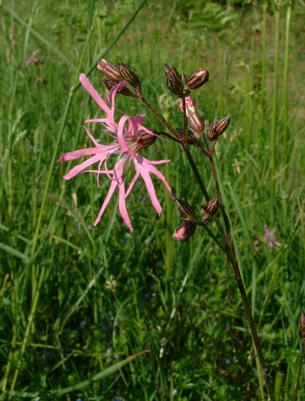
A close-up view of a pink Ragged Robin flower with deeply divided petals blooming in a green meadow.
Ragged Robin (Lychnis flos-cuculi) wildflower in the meadow habitat of the Petite Becque reserve.

Réserve naturelle régionale du vallon de la Petite Becque history and protected-area timeline

Long before it was legally protected, the site that is now the Réserve naturelle régionale du vallon de la Petite Becque was simply a wet valley-bottom pasture, crossed by the Petite Becque stream and dotted with a pond surrounded by willows. Local farmers kept the area as pasture or hay meadow because the heavy, flooded soils could not be cropped profitably; the surrounding bocage of hedges and small parcels was typical of the Flemish Houtland until the middle of the twentieth century.

The decisive break came in the second half of the twentieth century, when the countryside around Herzeele and Bambecque was transformed by post-war agricultural modernization: large-scale drainage, pesticide use, hedge removal, deep ploughing of old meadows, and the flattening of earthen banks. These changes turned the majority of the Houtland into open arable fields and pushed wild plants and animals out of the working landscape. The Petite Becque site, too wet to drain economically, was spared, and quietly became a refuge for the species the modernized plain could no longer host.

Formal recognition came in 1996, when the site was designated as a Réserve Naturelle Volontaire (RNV), a voluntary agreement between landowners and the regional naturalist network. When French legislation in 2002 (the loi "démocratie de proximité") abolished the RNV category, the site had to be reclassified. The reclassification procedure culminated on 4 October 2010, when the Réserve naturelle régionale du vallon de la Petite Becque (RNR223) was officially created and entrusted to the Conservatoire d'espaces naturels du Nord et du Pas-de-Calais, which continues to manage it today in close partnership with the local drainage union.

Réserve naturelle régionale du vallon de la Petite Becque landscape and geographic character

The Petite Becque reserve lies in a low-lying valley floor of the Houtland, the interior Flemish natural region that lies inland of the Dunkirk coastal plain. Its landform is essentially a flat or gently sloping wet valley-bottom, with the small meandering channel of the Petite Becque cutting through it. To the south of the site rises the gentle relief of the surrounding plateau, but within the reserve the visible scenery is dominated by open meadows, a pond framed by old willows, a single planted hedge, and the reed-fringed banks of the stream itself.

The micromosaic is very compact. Stripped of any major topographic drama, the landscape's character comes instead from the contrast between this small, lush, green wetland pocket and the wide, open, openfield-dominated plateau around it. The horizontal spread of water-meadow, the vertical accents of pollarded willows, and the linear fringe of the stream create a strongly pastoral scene that reads, at close range, as a relic of the bocage that once covered the whole Houtland, but from a wider perspective appears as a small island inside the modern arable matrix.
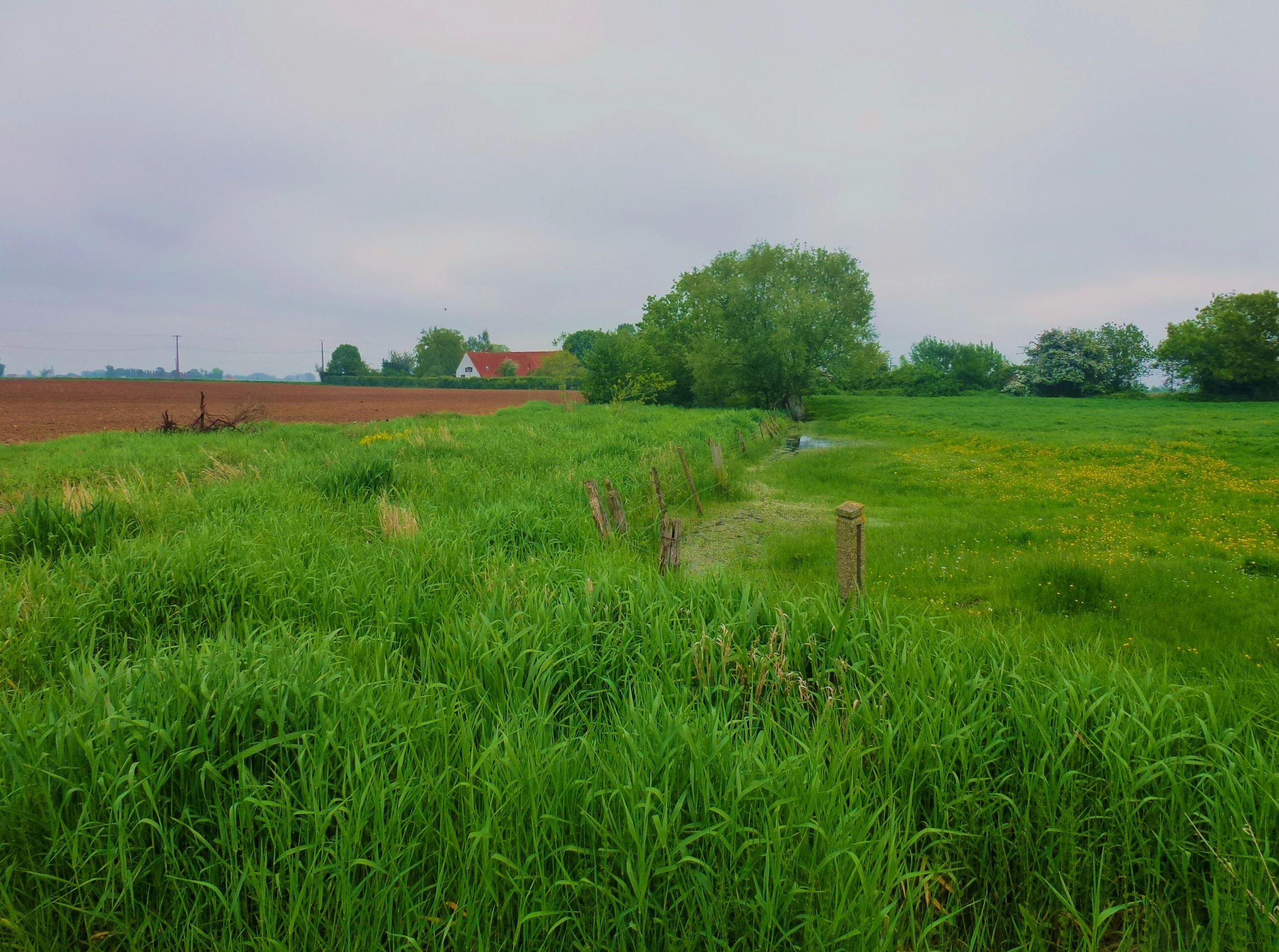
A landscape view showing a grassy field with a fence line, leading toward trees and a building in the distance under an overcast sky.
A view of the humid meadows and landscape in the Petite Becque valley.

Réserve naturelle régionale du vallon de la Petite Becque ecosystems, habitats, and plant life

Ecologically, the reserve functions as a small relictual wetland system and as a reference site for the lost bocage habitats of French Flanders. The biotopes the management plan prioritizes are the wet meadows, the pollarded willows, the hedge, the pond and the bed and banks of the Petite Becque. Together these form a tight ecological network in which aquatic, semi-aquatic, meadow and woody habitats sit side by side, supporting species that could not survive in any one of these habitats alone.

The plant communities are essentially herbaceous, dominated by species of wet and marshy ground. Around the pond and along the stream edges, communities of yellow iris and marsh marigold mingle with ragged-robin and other damp-meadow plants. The meadows themselves contain a rich grassland flora that includes several protected or regionally threatened species of the former Nord-Pas-de-Calais region, notably the southern marsh-orchid (Dactylorhiza praetermissa), the marsh valerian (Valeriana dioica) and the wood club-rush (Scirpus sylvaticus). The old willows and the dead wood they carry support a distinctive saproxylic community, including the fungi and invertebrates that depend on decaying wood, while the moss and leaf-litter layer of the undisturbed meadow is unusually rich in soil invertebrates because the ground has never been ploughed.

In a wider regional perspective, the site is also a reservoir of the traditional agro-ecosystem of the Flemish Houtland, an area that was once wooded, then became a bocage of hedges, ponds and small fields, before being reshaped into open arable country by the great remembrements of the second half of the twentieth century. This makes the reserve simultaneously a piece of living natural heritage and a memory of how the surrounding landscape used to function.
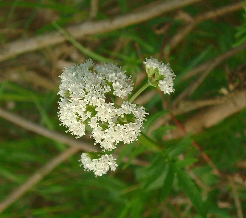
A close-up shot of a cluster of small white flowers on a thin green stem, surrounded by blurred green vegetation.
A close-up view of a marsh valerian flower, often found in wetland habitats within the nature reserve.

Réserve naturelle régionale du vallon de la Petite Becque wildlife and species highlights

The fauna of the Petite Becque reserve is closely tied to its mosaic of wet meadows, ponds, hedges and old willows. Birds are typical of open countryside and of habitats associated with willows and hedgerows: species that find nesting sites in the willow crowns and songbirds and small game that use the dense, low cover of the hedge corridor. Small mammals shelter in the same hedge-and-meadow complex.

The stream itself is one of the reserve's signature features for wildlife. The Petite Becque still holds populations of the three-spined stickleback and the smaller nine-spined stickleback, two small fish that were once extremely common across western Europe but have sharply retreated from modernized agricultural landscapes, making their presence here a meaningful conservation signal. The bank vegetation and the undisturbed silty bottom also support a rich invertebrate community.

Invertebrate diversity is one of the reserve's strengths. The meadow is home to several grasshoppers and bush-crickets, including the long-winged conehead and the meadow grasshopper. The pond is colonized by several dragonflies and damselflies, with species such as the blue-tailed damselfly, the azure damselfly and the black-tailed skimmer breeding in its open water. Below the surface, the protected meadows shelter a community of soil invertebrates that has benefited from the absence of ploughing. Finally, the old pollarded willows and their dead wood provide habitat for cavity-nesting birds and bats, as well as a saproxylic invertebrate community dependent on decaying wood, all reinforced by the presence of saproxylic fungi.

Réserve naturelle régionale du vallon de la Petite Becque conservation status and protection priorities

Conservation-wise, the Petite Becque reserve is significant far out of proportion to its size. It is one of the very few surviving fragments of the traditional bocage of French Flanders in this part of the Houtland, all of which was otherwise swept away by mid-twentieth-century agricultural modernization. By preserving wet meadows, ponds, hedgerows and old willows within a single small site, it protects not just individual species but a functional agro-ecological ensemble that has all but disappeared from the surrounding Dunkerquois plain.

The reserve is also recognized as a strategic node of the regional ecological network. The Hauts-de-France green infrastructure (trame verte) and the Dunkerquois ecological corridors rely on small, well-managed stepping-stones like this one to allow woodland, wetland and meadow species to move through a landscape that is otherwise dominated by intensive arable fields. The site's classification under IUCN Category IV, as a habitat/species management area, reflects exactly this role: it is protected and actively managed to maintain the habitats that make recolonization of the wider plain possible.

Management practice matches that role. The Conservatoire d'espaces naturels du Nord et du Pas-de-Calais, working with the local drainage union, has restored the polluted pond, removed dredged sediments dumped along the stream, replanted a hedge as a buffer against agricultural drift, resumed pollarding the willows to maintain nesting and saproxylic habitat, and reintroduced summer hay-cutting with exported cuttings, a regime that explicitly favours the orchid-rich meadows for which the site is most valued.

Réserve naturelle régionale du vallon de la Petite Becque cultural meaning and human context

Beyond strictly ecological value, the reserve carries a clear cultural message. It preserves a working memory of how the Flemish Houtland used to look and function, before the great remembrements of the 1960s through the 1990s converted a wooded and bocage landscape into vast open arable fields. The pastoral meadow, the pond once used to water livestock, the willows traditionally cut for wood poles, the hedge as field boundary, and the small stream used by the rural community together represent the everyday rural environment of generations of Flemish farmers.

Present-day management deliberately keeps several of these traditional elements alive: the willows are still pollarded in the old style to provide perches and to support wildlife, the meadows are still mown for hay, and the partnerships with local authorities and landowners reflect the social fabric of rural Flanders. In this sense the Petite Becque reserve is as much a piece of regional heritage as a strictly natural area, an example of how nature conservation in northern France is inseparable from the cultural landscape of villages like Herzeele and Bambecque.

Top sights and standout views in Réserve naturelle régionale du vallon de la Petite Becque

The Petite Becque reserve is a compact showcase of an entire vanished Flemish bocage landscape compressed into less than one hectare: wet meadows, a pond, a hedge-fringed stream corridor and a line of old pollarded willows. It shelters 111 recorded plant species, including protected orchids and relict marsh plants that have been pushed out of the surrounding intensive farmland; it is a stronghold of sticklebacks and dragonflies whose regional populations are otherwise declining; and its pollarded willows harbour an unusual saproxylic community. It also operates as a working laboratory for integrating traditional rural practices with modern ecological restoration in intensively farmed northern France.

Best time to visit Réserve naturelle régionale du vallon de la Petite Becque

The reserve has gentle, low-lying terrain and a strongly seasonal ecological character shaped by its wet meadows and pond. Late spring and early summer are typically the most rewarding window for wildflower diversity, when orchids, ragged-robin, yellow iris and marsh marigold are at their peak along the stream and around the pond. Dragonflies and damselflies tend to be most active in the warmer, still days of mid to late summer around the open water. Late summer and early autumn are also the period when the management hay cut takes place, leaving the meadows briefly open before they regrow. Access is allowed only on part of the site, and dogs are not permitted.
Monthly climate preview

Long-term representative point measurements tracking monthly temperature and precipitation rhythms

Annual Climate Normals and Temperature Patterns for Réserve naturelle régionale du vallon de la Petite Becque

Representative coordinates record measured multi-year averages spanning cool winter lows and warmer summer maximums alongside steady daily precipitation. Detailed monthly climate records outline the full annual cycle for this protected area.
Annual mean11 °C
4 °C18 °C
Jan
Feb
Mar
Apr
May13°
Jun15°
Jul17°
Aug18°
Sep15°
Oct12°
Nov
Dec
Warmest month
August

17.7 °C

Coolest month
January

4.3 °C

Wettest month
November

2.7 mm/day

Driest month
April

1.4 mm/day

Park location guide

Geography guide, regional context, and park location map for Réserve naturelle régionale du vallon de la Petite Becque

Réserve naturelle régionale du vallon de la Petite Becque park geography, regions, and map view in France

Understand where Réserve naturelle régionale du vallon de la Petite Becque sits in France through a broader geographic reading of the surrounding landscape, nearby location context, and its mapped position within the national park landscape.

How Réserve naturelle régionale du vallon de la Petite Becque fits into France

France is a unitary semi-presidential republic and one of the world's largest economies. It borders Belgium, Luxembourg, Germany, Switzerland, Italy, Monaco, Andorra, and Spain, with a maritime border to the United Kingdom. The country is known for its cultural influence, art, cuisine, and political history spanning centuries.

Wider geography shaping Réserve naturelle régionale du vallon de la Petite Becque in France

France is located in Western Europe. Metropolitan France extends from the Rhine to the Atlantic Ocean and from the Mediterranean Sea to the English Channel and North Sea. The country borders Belgium, Luxembourg, Germany, Switzerland, Italy, Monaco, Andorra, Spain, and has a maritime border with the United Kingdom.

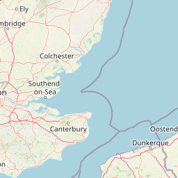
Map view of Réserve naturelle régionale du vallon de la Petite Becque

Use this park location map to pinpoint Réserve naturelle régionale du vallon de la Petite Becque in France, understand its exact geographic position, and read its mapped placement within the surrounding landscape more clearly.

Pigeon | © OpenStreetMap contributors

Location context for Réserve naturelle régionale du vallon de la Petite Becque

Hauts-de-France

Visual reference guide to wet meadows, pollarded willows, and relict Flemish habitats

Réserve naturelle régionale du vallon de la Petite Becque Photos and Protected Landscape Scenery

Visual documentation captures the rare wetland habitats, winding stream corridors, and traditional bocage remnants preserved within Réserve naturelle régionale du vallon de la Petite Becque. Detailed photography reveals the distinctive micro-mosaics of this protected Flemish reserve against the surrounding agricultural plains.

A close-up view of a pink Ragged Robin flower with deeply divided petals blooming in a green meadow.

A green, grassy field with white wildflowers, framed by dense green bushes and trees under an overcast sky.

A landscape view showing a grassy field with a fence line, leading toward trees and a building in the distance under an overcast sky.

A close-up shot of a cluster of small white flowers on a thin green stem, surrounded by blurred green vegetation.

Park atlas

Compare nearby protected areas and regional wetland landscapes across northern France

Parks Near Réserve Naturelle Régionale Du Vallon De La Petite Becque

Browse other protected areas and regional nature reserves situated across the surrounding Flemish Houtland. Comparing adjacent wetland habitats and valley ecosystems helps contextualize local conservation networks.
A soft watercolor painting of a green meadow, featuring gentle hills in the distance, a small stream flowing through the center, and a few scattered trees, all set against a white background.
Nature reserveHauts-de-France
About 18 km away#1 closest

Southwest

Réserve naturelle régionale des prairies du Schoubrouck: Geography and Protected Area Overview

Wet-meadow habitats and historic watergang networks in northern France.

Located in the Hauts-de-France region, Réserve naturelle régionale des prairies du Schoubrouck provides a focused look at the cultural and ecological heritage of Flemish lowland landscapes. This site preserves an essential mosaic of wet grasslands and traditional drainage systems, serving as a key example of habitat-specific conservation stewardship within the rural fabric of the Nord department.

Area
0.102 km²
Established
2012
IUCN
IV
Watercolor painting showing layered rolling hills or dunes in shades of green, purple, and pale pink against a white background.
Nature reserveHauts-de-France
About 20 km away#2 closest

North

Réserve naturelle nationale de la dune Marchand: Protected Coastal Dune Landscapes

Coastal Flemish dunes and North Sea protected geography

Located in the Hauts-de-France region, the Réserve naturelle nationale de la dune Marchand is a protected area defined by its rare continuity of dune habitats. From wind-scoured slacks to established grey dunes and wetland pockets, the reserve provides a critical study of coastal topography and endemic species preservation within an active maritime border landscape.

Area
1.13 km²
Established
1974
IUCN
IV
Relief
Lowland
Nature reserveHauts-de-France
About 21 km away#3 closest

Northwest

Réserve naturelle régionale de Grande-Synthe: Protected Geography and Regional Mapping

Nature reserve landscapes in the Hauts-de-France coastal plain

Spanning 174 hectares on the edge of the Dunkirk urban zone, this protected area serves as a model for ecological restoration. Examine the patchwork of sandy grasslands, wetlands, and mature hedgerows that define the reserve, and see its position as a link in the regional green and blue ecological corridor of northern France.

Area
1.74 km²
Established
2015
Relief
Lowland
Climate
Temperate
Nature reserveHauts-de-France
About 26 km away#4 closest

Southwest

Réserve naturelle régionale du plateau des landes: Regional Nature Reserve Landscape Profile

Protected heathland geography in the Pas-de-Calais corridor.

Understand the ecological structure of the Réserve naturelle régionale du plateau des landes. This protected area features a unique crescent shape and mosaic of heathland sectors spread across several communes, offering a focused study of low-elevation inland conservation management in the heart of northern France.

Area
1.811 km²
Established
2009
IUCN
IV
A soft watercolor painting showing a panoramic landscape with light green trees and low hills in the background, set against a pale, washed-out sky.
Nature reserveHauts-de-France
About 30 km away#5 closest

Southeast

Réserve naturelle régionale des prés du Moulin Madame: Regional Protected Meadow Map

Riverine floodplain landscapes in the Hauts-de-France region

The Réserve naturelle régionale des prés du Moulin Madame protects an 8.52 hectare corridor along the Lys river. This site highlights the preservation of traditional flood meadows that are increasingly rare in northern France. Users can examine the park boundaries, understand the flat lowland terrain, and trace the riverine geography that defines this unique protected cultural landscape.

Area
0.085 km²
Established
2015
IUCN
IV
A horizontal watercolor painting showing a soft coastal scene with rolling dunes, sparse grasses, and a calm shoreline under a light sky.
Nature reservePas-de-Calais
About 34 km away#6 closest

West

Réserve naturelle nationale du Platier d'Oye: Protected Coastal Landscape and Wetland Geography

Coastal dunes and migratory bird habitats in Pas-de-Calais

Located along the Opal Coast, the Réserve naturelle nationale du Platier d'Oye represents a complex mosaic of tidal flats, mobile sand dunes, and humid polder meadows. This protected area offers unique insight into the ecological intersection of maritime forces and terrestrial environments, functioning as a primary staging ground for diverse migratory species within the Hauts-de-France coastal region.

Area
3.91 km²
Established
1987
IUCN
IV
Relief
Lowland
A soft watercolor painting of a grassy landscape with exposed limestone rock faces and green vegetation.
Nature reserveHauts-de-France
About 38 km away#7 closest

Southwest

Réserve naturelle régionale des anciennes carrières de Cléty: Protected Geological Landscape

Regional nature reserve in the Hauts-de-France, France

A significant geological protected area in the Pas-de-Calais, this reserve features an exposed chalk quarry face that serves as a stratigraphic record for the Cretaceous period. The landscape hosts a rare intersection of geological heritage and diverse ecosystems, including orchids, butterflies, and bat colonies, within a compact footprint.

Area
0.02 km²
Established
2011
IUCN
IV
Nature reserveHauts-de-France
About 39 km away#8 closest

West

Réserve naturelle régionale de Pont d'Ardres: Mapped Wetland Geography and Protected Lands

A restored industrial landscape in the Hauts-de-France coastal hinterland.

Situated southeast of Calais, this reserve represents a rare success in ecological restoration. The former sugar factory basins now provide vital habitats for shorebirds and nesting species, maintaining an essential wetland presence in an otherwise cultivated landscape of northern France.

Area
0.663 km²
Established
2012
IUCN
IV
Relief
Lowland

Common questions about visiting, size, designation, and location context for Réserve naturelle régionale du vallon de la Petite Becque

Réserve naturelle régionale du vallon de la Petite Becque FAQs for park facts, access, geography, and protected area context

Find quick answers about Réserve naturelle régionale du vallon de la Petite Becque, including protected-area facts, park geography, trail and visitor context, and how the park fits into its surrounding country and regional landscape.
MoriAtlas Explorer

Continue Your Protected Areas Search Across the Global Atlas

Deepen your exploration by continuing the structured search for national parks and protected areas worldwide. Utilize the comprehensive filtering capabilities to compare different conservation landscapes and refine your understanding of global park geography. Discover more about the distribution and characteristics of protected natural areas.

Global natural geography