
Mori Atlas logo
Nature reserveRéserve naturelle régionale du Massif du Montious

Geographic analysis of granitic mountain terrain, glacial lakes, and montane ecosystems

Réserve naturelle régionale du Massif du Montious: Central Pyrenees Protected Landscape

(Réserve naturelle régionale du Massif du Montious (RNR326))

The Réserve naturelle régionale du Massif du Montious protects a diverse mosaic of Central Pyrenean environments across 740 hectares within the Hautes-Pyrénées. This protected area showcases a complete ecological gradient, from montane forests and high-altitude grasslands to headwater wetlands and the glacial Lac de Bordères. The reserve serves as a critical geological reference site, revealing the Hercynian mountain chain formation through its complex granitic outcrops and plutonic rock structures.

regional nature reservePyreneesCentral PyreneesHercynian geologygranitic massifglacial lake
A stylized flat vector illustration of mountain peaks above a forest and a small lake, set against a pale sky with white clouds.

Réserve naturelle régionale du Massif du Montious

Nature reserve

Park overview

Structured park overview, official facts, and landscape profile for Réserve naturelle régionale du Massif du Montious

Réserve naturelle régionale du Massif du Montious park facts, protected area profile, and essential visitor context

Review the core facts for Réserve naturelle régionale du Massif du Montious, including designation, size, terrain, visitor scale, habitats, and operating context in one park-focused overview.

About Réserve naturelle régionale du Massif du Montious

The Réserve naturelle régionale du Massif du Montious occupies a privileged position on the flanks of the Montious massif in the Vallée du Louron, in the heart of the Central Pyrenees. Encompassing the entire range of elevations found locally between forested slopes and alpine summits, the reserve brings together habitats that in many mountain regions are scattered across much wider distances. The result is a compact, ecologically dense protected area where transitions between forest, wetland, meadows, and high-altitude rocky environments can be observed within a single site.

Its environmental mission is closely tied to the protection of Pyrenean biodiversity. The mosaic of habitats here shelters species that have become priorities for conservation at both regional and national levels, ranging from small aquatic mammals like the Pyrenean desman to large forest birds such as the Western Capercaillie. The presence of such species throughout the site's recent history has shaped successive protection efforts, beginning with earlier biological and hunting reserves and culminating in the Regional Nature Reserve designation in 2020.

Beyond its ecological functions, the reserve is also a site of significant geological and scientific interest. The Montious exposures are formally described as the best local example of the stages of formation of a granitic pluton within the Hercynian orogen, providing an open-air reference for plutonic and metamorphic processes. This combination of ecological richness and geological heritage gives the reserve a dual identity: it is simultaneously a refuge for living Pyrenean nature and an archive of deep mountain-building history.

The practical experience of the reserve is shaped by its dual-zone management approach, which distinguishes a general Protection Zone around the lake from a Reinforced Protection Zone requiring strict trail adherence. Educational programming organised by the co-management team extends the reserve's role beyond conservation, positioning it as an outdoor classroom for understanding the central Pyrenean environment.

Quick facts and research context for Réserve naturelle régionale du Massif du Montious

The Réserve naturelle régionale du Massif du Montious is a French Regional Nature Reserve classified on 16 July 2020 by the Occitanie Regional Council. It lies entirely on the commune of Bordères-Louron in the Hautes-Pyrénées department, within the Vallée du Louron. Its area spans approximately 738 hectares at elevations ranging from about 1,590 metres to 2,171 metres, the latter corresponding to the summit of Montious.

The reserve is classified as IUCN Category IV (Habitat/Species Management Area) and registered in the World Database on Protected Areas. It is co-managed by the commune of Bordères-Louron and the association Nature En Occitanie. The site includes the Lac de Bordères, montane forest cover, alpine pastures, headwater wetlands, and a notable Hercynian-era granitic geological formation. Western Capercaillie presence has historically been a central driver of its protection.

Protection and recognition

Documented protected area designation records and official database metrics

Protection Status and International Recognition for Réserve naturelle régionale du Massif du Montious

Protected area designation records for Réserve naturelle régionale du Massif du Montious outline the formal management scope and baseline geographic status. Official database entries aggregate available administrative metrics to establish a clear framework for conservation tracking.

Protection details

WDPA ID
555702232
Park context

Deeper park guide and search-rich context for Réserve naturelle régionale du Massif du Montious

Réserve naturelle régionale du Massif du Montious history, landscape, wildlife, and travel context

Explore Réserve naturelle régionale du Massif du Montious through its history, landscape character, ecosystems, wildlife, conservation priorities, cultural context, and seasonal travel timing in a structured park guide built for atlas discovery and search intent.

Why Réserve naturelle régionale du Massif du Montious stands out

The reserve is best known for combining a diverse Pyrenean ecological mosaic with exceptional geological heritage. Within its relatively compact area, visitors and researchers find glacial lake environments, montane forests, high-altitude grasslands, and headwater wetlands that together represent the full ecological gradient of the Central Pyrenees. The Lac de Bordères serves as both a scenic landmark and a sensitive aquatic habitat, hosting species such as the grass-leaved pondweed. Equally important is the reserve's geological significance, where the rocky exposures around Montious are recognised as one of the best local illustrations of the formation of the Hercynian mountain chain. The presence of gabbros, leucocratic rocks, diorites, and granitic chaos offers a tangible record of plutonic intrusion processes. The reserve is also recognised for its Western Capercaillie populations, which have shaped its long conservation history.
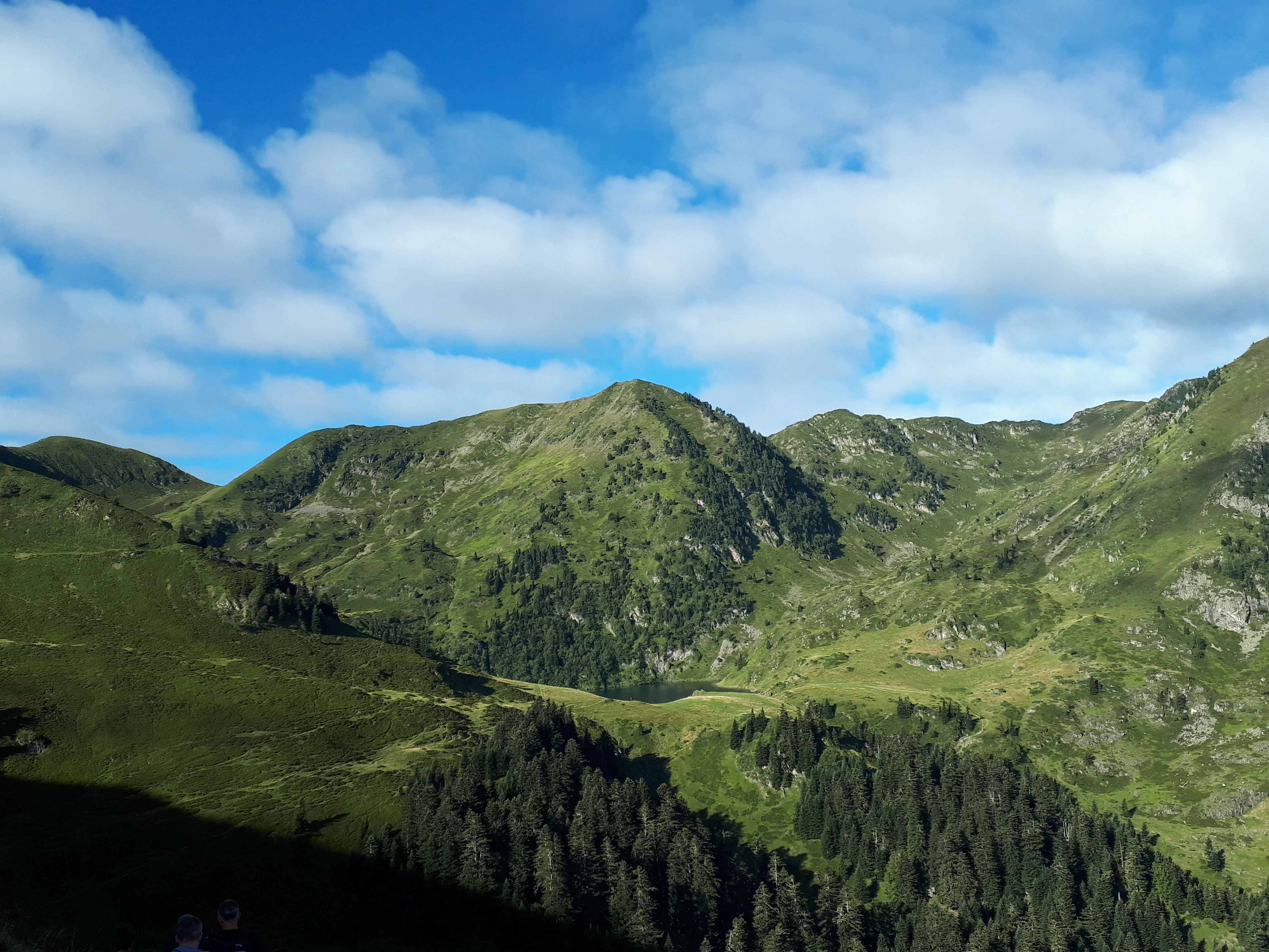
A wide view of green mountain slopes and pine forests in the Pyrenees under a sky with scattered white clouds.
A scenic view of the mountainous landscape within the Massif du Montious Regional Nature Reserve.

Réserve naturelle régionale du Massif du Montious history and protected-area timeline

Long before its formal protection, the Massif du Montious was recognised locally as an area of exceptional natural value. Between 1993 and 1995, the commune of Bordères-Louron explored the possibility of classifying the site as a managed biological forest reserve, but the project was ultimately not pursued. In September 1996, the presence of the Western Capercaillie on the massif led to the designation of a wildlife and hunting reserve, marking the first formal protective status for the area.

The next major step came in November 2013, when the municipal council of Bordères-Louron voted in favour of pursuing a Regional Nature Reserve classification based on a project presented by the mayor. A formal classification request was then submitted to the Occitanie region on 15 October 2018. Following several years of preparation and review, the Occitanie Regional Council, meeting in plenary assembly, formally created the Réserve Naturelle Régionale du Massif du Montious on 16 July 2020.

This designation made it the 14th Regional Nature Reserve in the Occitanie region and brought the site's protection under a long-term framework co-managed by the commune and the Nature En Occitanie association. The reserve's history therefore reflects a progression from species-focused protection, through an ambitious but unrealised forest reserve plan, to a comprehensive regional designation that integrates ecological, geological, and educational objectives.

Réserve naturelle régionale du Massif du Montious landscape and geographic character

The Montious massif rises to 2,171 metres at its summit, the highest point within the reserve, while the lower boundary of the protected area descends to around 1,590 metres. This elevation range of more than 500 metres produces sharply contrasting landscapes within the boundaries of a single property. The north-eastern face of Montious dominates the eastern part of the reserve, while the western portion extends across slopes with southern exposures, creating varied orientations of light, vegetation, and microclimate.

The scenery is fundamentally shaped by the underlying geology. Glacial action has left its mark on the terrain, including the Lac de Bordères, a small glacial lake that today serves as both a visual anchor for the reserve and a delicate aquatic habitat. Around the lake and across the slopes, granitic chaos and rocky outcrops punctuate the vegetated surfaces, reflecting the plutonic origins of the massif. Forest stands, particularly on the more sheltered aspects, contrast with the open, lighter tones of the alpine and subalpine grasslands above.

Headwater wetlands add a quieter, gentler dimension to the landscape, occupying transitional zones where water emerges from higher ground. Together, the lake, forests, summit pastures, and wet flushes create the visual and ecological richness that characterises the reserve, illustrating how the Central Pyrenees can compress multiple landscape characters into a relatively contained area.

Réserve naturelle régionale du Massif du Montious ecosystems, habitats, and plant life

The reserve captures a representative cross-section of vegetation types found in the Central Pyrenees, ranging from montane communities on the lower slopes to subalpine formations near the summit. Forests cover a substantial portion of the site, while higher elevations give way to pastures, rocky environments, and specialised flora adapted to alpine conditions. This layered vegetation reflects the strong elevational gradient that defines the Pyrenean ecosystems and supports a remarkable diversity of microhabitats.

Wetland systems are among the most ecologically sensitive features of the reserve. The Lac de Bordères and associated headwater wetlands host specialised aquatic and semi-aquatic plant species, and the surrounding flushes contribute to the hydrological integrity of upper catchments. Plants such as the round-leaved sundew, which thrives in nutrient-poor wet soils, illustrate the continuity between botanical and hydrological values in this kind of habitat.

The reserve also protects several plant species of conservation concern. Notable among them are the heart-leaved twayblade, an orchid species, and the Ramonda des Pyrénées, a relict plant emblematic of ancient montane floras. The presence of these species within a relatively restricted area reinforces the reserve's importance as a refuge for plant diversity typical of, and in some cases distinctive to, the Central Pyrenees.

Réserve naturelle régionale du Massif du Montious wildlife and species highlights

The wildlife of the Massif du Montious reflects the diversity of habitats and the transitional nature of the reserve between forested and open landscapes. The Western Capercaillie has been a flagship species for the site since the introduction of the first hunting and wildlife reserve in 1996, and remains an important indicator of forest quality and habitat connectivity in the upper Louron valley.

More cryptic species are equally significant for the reserve's conservation value. The Pyrenean desman, a small aquatic mammal endemic to the Pyrenees and the northern Iberian Peninsula, occupies the mountain streams and wet habitats of the area, making the reserve part of the broader network of sites essential to its long-term survival. A range of bat species, including Natterer's bat, the European free-tailed bat, grey and brown long-eared bats, and Leisler's bat, also find roosting and foraging conditions here, contributing to the site's importance for nocturnal fauna.

Among birds, the rock thrush and the Pyrenean grey partridge stand out as species of conservation interest, while invertebrates add an often-overlooked dimension. The semi-Apollo butterfly and the moraine grasshopper (Miramelle des moraines) are flagship insect species that reflect the integrity of the open rocky and meadow environments. Taken together, this combination of mammals, birds, and invertebrates confirms the reserve's ecological breadth and conservation relevance.

Réserve naturelle régionale du Massif du Montious conservation status and protection priorities

The reserve was created in 2020 as a comprehensive Regional Nature Reserve precisely because the cumulative ecological value of the site could no longer be adequately protected under more limited or temporary designations. Its IUCN Category IV status reflects a management approach centred on the conservation of specific habitats and species, while still allowing certain compatible activities within strictly defined zones.

Conservation priorities on the site focus on maintaining forest continuity for large forest species such as the Western Capercaillie, protecting sensitive wetland and lake habitats from trampling and disturbance, and preserving the open rocky environments that host specialised invertebrates. Strict regulations prohibit fires, dogs (even on a leash), swimming, drone use, motor vehicles, the installation of photography hides, and any degradation or disturbance of natural heritage, thereby limiting the most disruptive forms of impact.

Daily environmental policing operations and on-site signage support compliance with these rules. The presence of reinforced protection zones around the most sensitive areas, traversed only by a single marked trail, illustrates a precautionary approach typical of relatively young reserves still establishing their long-term management framework. The combination of legal protection, regulated access, and active educational programming positions the reserve as a working example of integrated habitat and species conservation in the Pyrenees.

Réserve naturelle régionale du Massif du Montious cultural meaning and human context

The reserve lies entirely within the commune of Bordères-Louron, which owns all the classified parcels and has been a central actor in the site's long conservation history. This strong municipal involvement gives the protected area a distinctive local identity, rooted in a small Pyrenean community that has shaped its environmental choices through successive municipal decisions spanning several decades.

While the reserve does not focus on built cultural heritage, its creation reflects a broader regional movement in which Pyrenean communities have increasingly taken ownership of biodiversity protection as part of their territorial identity. The Vallée du Louron, in which Bordères-Louron is situated, is an area where traditional relationships between mountain landscapes, forestry, pastoralism, and wildlife remain perceptible, even if these activities are not the primary focus of nature management today.

The co-management with the association Nature En Occitanie also reflects a Region-wide framework for regional nature reserves, in which local communes and specialised conservation organisations share responsibility for protected areas. This arrangement connects a small commune in the central Pyrenees with a wider Occitanie network of protected natural sites.

Top sights and standout views in Réserve naturelle régionale du Massif du Montious

Among the reserve's most distinctive features is the combination of a glacial lake, montane-to-subalpine vegetation gradient, and Hercynian-era granitic geology within a single protected territory. The Lac de Bordères is a focal point for both landscape beauty and aquatic biodiversity, with species such as grass-leaved pondweed reflecting the fragility of the lake environment.

The geological exposures around Montious are a particular scientific highlight, recognised as the best local example of the stages of granitic pluton formation associated with the Hercynian chain. This gives the reserve value that extends well beyond its ecological role, making it a reference site for understanding the deep geological history of the Pyrenees. Forest cover, summit grasslands, and headwater wetlands complete the mosaic that makes the reserve a compact but comprehensive summary of the central Pyrenean natural environment.

Best time to visit Réserve naturelle régionale du Massif du Montious

As a high-altitude reserve ranging from roughly 1,590 to 2,171 metres, the Massif du Montious is best experienced in the milder and snow-free months, when trails around the Lac de Bordères and along the marked paths are most accessible and when the contrasts between forest cover, wet flushes, and alpine grasslands are most visible. Late spring and summer typically bring lush vegetation and active wildlife, including visible bat, bird, and insect activity, while the surrounding forests retain their full seasonal character.

Visit timing also influences how visitors perceive the geological and landscape features: exposed rocks and granitic chaos are especially visible under stable weather, and the lake environment is most safely appreciated when conditions are dry. Anyone planning to explore the reserve should keep in mind the strict regulations that prohibit dogs, drones, fires, swimming, and motor vehicles across the entire protected area, and the requirement to stay on designated trails in the most sensitive zones.

Monthly climate preview

Long term representative temperature and precipitation averages across twelve recorded monthly cycles

Annual Climate Normals and Temperature Rhythms for Réserve naturelle régionale du Massif du Montious

Representative coordinate records show wide annual temperature swings alongside steady precipitation rates across twelve monthly cycles. Reviewing the full monthly breakdown helps track detailed long term climate normals for Réserve naturelle régionale du Massif du Montious.
Annual mean10 °C
3 °C20 °C
Jan
Feb
Mar
Apr
May13°
Jun17°
Jul19°
Aug20°
Sep16°
Oct12°
Nov
Dec
Warmest month
August

19.7 °C

Coolest month
January

2.6 °C

Wettest month
November

3 mm/day

Driest month
July

1.7 mm/day

Park location guide

Geography guide, regional context, and park location map for Réserve naturelle régionale du Massif du Montious

Réserve naturelle régionale du Massif du Montious park geography, regions, and map view in France

Understand where Réserve naturelle régionale du Massif du Montious sits in France through a broader geographic reading of the surrounding landscape, nearby location context, and its mapped position within the national park landscape.

How Réserve naturelle régionale du Massif du Montious fits into France

France is a unitary semi-presidential republic and one of the world's largest economies. It borders Belgium, Luxembourg, Germany, Switzerland, Italy, Monaco, Andorra, and Spain, with a maritime border to the United Kingdom. The country is known for its cultural influence, art, cuisine, and political history spanning centuries.

Wider geography shaping Réserve naturelle régionale du Massif du Montious in France

France is located in Western Europe. Metropolitan France extends from the Rhine to the Atlantic Ocean and from the Mediterranean Sea to the English Channel and North Sea. The country borders Belgium, Luxembourg, Germany, Switzerland, Italy, Monaco, Andorra, Spain, and has a maritime border with the United Kingdom.

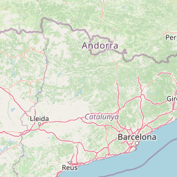
Map view of Réserve naturelle régionale du Massif du Montious

Use this park location map to pinpoint Réserve naturelle régionale du Massif du Montious in France, understand its exact geographic position, and read its mapped placement within the surrounding landscape more clearly.

Pigeon | © OpenStreetMap contributors

Location context for Réserve naturelle régionale du Massif du Montious

Occitanie

Visualizing glacial lakes, montane forests, and Hercynian geological formations across Central Pyrenean protected terrain.

Réserve naturelle régionale du Massif du Montious Photos, Scenery, and Landscapes

Photographs capture the diverse terrain of Réserve naturelle régionale du Massif du Montious, revealing glacial lakes, rocky granitic chaos, and alpine grasslands. Visual documentation clarifies the ecological gradient and protected landscape character unique to the Central Pyrenees.

A wide view of green mountain slopes and pine forests in the Pyrenees under a sky with scattered white clouds.

Park atlas

Compare nearby regional nature reserves and connected mountain landscapes across the Pyrenees.

Parks Near Réserve naturelle régionale du Massif du Montious and Surrounding Protected Areas

Browsing other protected areas near Réserve naturelle régionale du Massif du Montious reveals shared geological formations and montane ecosystems across the surrounding region. Extending the geographic comparison helps trace broader conservation patterns and regional park diversity in the Central Pyrenees.
A soft, watercolor painting depicting distant purple-hued mountain ranges fading into a pale, warm-toned sky, with light green hills and hints of pine forests in the foreground.
Nature reserveOccitanie
About 12 km away#1 closest

West

Réserve naturelle régionale d'Aulon: Mountain Geography and Protected Area Mapping

A diverse protected landscape spanning the central Pyrenees of Occitanie.

This regional nature reserve provides a focused look at central Pyrenean mountain environments. Covering over 1,200 hectares, the area features a steep altitudinal gradient, blending working pastoral meadows with critical habitats such as rocky slopes, conifer forests, and glacial landforms. The site serves as a vital anchor within the broader network of protected mountain terrain found throughout the Occitanie region.

Area
12.37 km²
Established
2001
IUCN
IV
Relief
Mountain
National parkHautes-Pyrénées
About 23 km away#2 closest

West

Pyrénées National Park: Protected Landscape & Transboundary Protected Area Atlas

Discover Hautes-Pyrénées' dramatic glacial terrain and alpine environments.

Pyrénées National Park is a significant protected area in France's Hautes-Pyrénées department, renowned for its dramatic glacial cirques, high-altitude lakes, and extensive mountain landscapes. Established as a national park, it offers rich geographic context for atlas exploration, showcasing millions of years of geological formation shaped by tectonic uplift and glacial carving. This park is also notable for its transboundary conservation efforts with Spain, contributing to a broader protected region. Explore its unique terrain, from towering limestone formations to alpine meadows, and understand its place within the Pyrenean mountain range.

Area
458 km²
Established
1967
IUCN
II
Relief
Mountain
Watercolor painting showing a mountain range with a winding river through a valley
National parkSpain
About 35 km away#3 closest

Southwest

Ordesa y Monte Perdido National Park: Glacial Terrain and Pyrenean Protected Landscape

Explore its dramatic valleys, cliffs, and alpine geography.

Ordesa y Monte Perdido National Park is a critical protected area within the Pyrenean geography, defined by its spectacular glacial valleys, towering limestone massifs, and unique karst formations. As a National Park and UNESCO World Heritage Site, it offers a rich environment for exploring mapped terrain and understanding the interplay of geology and high-alpine ecosystems. Delve into the mapped boundaries and distinct landscape features that characterize this significant protected landscape.

Area
156.08 km²
Established
1918
IUCN
II
Relief
Mountain
A soft watercolor painting of rolling green hills, distant mountain peaks, and a calm water body against a white background.
National parkOccitanie
About 41 km away#4 closest

Southwest

Pyrénées-Mont Perdu National Park: Alpine Geography and Transboundary Protected Landscapes

Glacial cirques, limestone canyons, and alpine pastoral heritage.

Spanning the high Pyrenees, Pyrénées-Mont Perdu represents a rare union of dramatic geological formations and human cultural heritage. The terrain features vertical limestone walls, deep carved canyons, and expansive cirques that host both diverse alpine ecosystems and active seasonal migration routes. This protected area remains a benchmark for studying the interplay between powerful glacial geography and historic mountain pastoralism in Europe.

Area
306.39 km²
Established
1997
Relief
Mountain
Climate
Alpine
Watercolor illustration of a mountainous landscape with a river, green vegetation, and distant peaks under a light sky
National parkProvince of Lleida
About 43 km away#5 closest

Southeast

Aigüestortes i Estany de Sant Maurici National Park: Pyrenean High Mountain National Park Landscape

Explore glacial lakes and winding waterways in Catalonia.

Aigüestortes i Estany de Sant Maurici National Park is a premier national park in the Pyrenees, celebrated for its extensive network of almost 200 glacial lakes and the dramatic natural beauty of the Sant Maurici lake. Its landscape is defined by high mountain terrain, characterized by U-shaped valleys, sharp ridges, and unique hydrological features like the Aigüestortes plain's meandering streams. This protected area in the Province of Lleida offers a rich setting for understanding alpine environments and Pyrenean geography through detailed mapping and atlas exploration.

Area
141 km²
Established
1955
IUCN
II
Visitors
525K annual
A watercolor illustration of rolling mountain ranges and stylized forest patches in soft green and earth tones against a pale background.
Nature reserveOccitanie
About 52 km away#6 closest

Northwest

Réserve naturelle régionale du massif du Pibeste-Aoulhet: Mountain Reserve Atlas

Regional protected landscape mapping in the French Pyrenees

Spanning over 5,000 hectares in the Occitanie region, the Réserve naturelle régionale du massif du Pibeste-Aoulhet serves as a critical biological corridor. This detailed record examines the massif's varied elevations, from lower broadleaf forests to high-altitude rocky cliffs, highlighting its status as one of the largest regional nature reserves in France.

Area
51.103 km²
Established
2012
IUCN
IV
Relief
Mountain
Nature reservePyrénées-Atlantiques
About 66 km away#7 closest

West

Vallée du Soussouéou Protected Nature Reserve: Geographic Atlas and Mountain Terrain

A roadless glacial valley in the French Pyrénées-Atlantiques

Vallée du Soussouéou offers a rare glimpse into a roadless Pyrenean landscape. This protected area features a classic glacial U-shaped valley, significant peatland ecosystems, and diverse alpine habitats that support Pyrenean fauna. As a quiet extension of the ecological network in the Western Pyrenees, the valley remains an important site for understanding mountain geography and glacial geomorphology in southwestern France.

Area
45.39 km²
Established
1995
Relief
Mountain
Scope
Terrestrial
Watercolor painting of a river winding through a valley with green fields, trees, and distant hills
Protected areaAndorra
About 86 km away#8 closest

East

Parc Natural Comunal de les Valls del Comapedrosa: Andorra's Highest Protected Alpine Landscape

Explore the Pyrenean terrain and mapped boundaries of Andorra's summit park.

Parc Natural Comunal de les Valls del Comapedrosa is the primary high-altitude protected area in Andorra, defined by its rugged alpine terrain and the presence of Coma Pedrosa, the country's highest peak. This protected landscape offers a significant geographic anchor for exploring the Pyrenees, highlighting the unique mountain conservation efforts. Its mapped boundaries encompass dramatic valleys and steep ridges, providing a clear context for understanding Andorra's mountainous geography through a structured atlas lens.

Area
15.43 km²
Established
2003
IUCN
IV
Relief
Mountain

Common questions about visiting, size, designation, and location context for Réserve naturelle régionale du Massif du Montious

Réserve naturelle régionale du Massif du Montious FAQs for park facts, access, geography, and protected area context

Find quick answers about Réserve naturelle régionale du Massif du Montious, including protected-area facts, park geography, trail and visitor context, and how the park fits into its surrounding country and regional landscape.
MoriAtlas Explorer

Continue Your Protected Areas Search Across the Global Atlas

Deepen your exploration by continuing the structured search for national parks and protected areas worldwide. Utilize the comprehensive filtering capabilities to compare different conservation landscapes and refine your understanding of global park geography. Discover more about the distribution and characteristics of protected natural areas.

Global natural geography