Mori Atlas logo
Nature reserveRéserve naturelle régionale du Puy de Marmant

Examining the geological heritage and thermophilous dry grassland habitats of this protected French reserve.

Réserve naturelle régionale du Puy de Marmant: A Volcanic Landscape in Auvergne-Rhône-Alpes

(Réserve naturelle régionale du puy de Marmant)

The Réserve naturelle régionale du Puy de Marmant stands as a distinct volcanic landform rising above the Limagne plain in the Auvergne-Rhône-Alpes region. This protected area preserves an ancient phreatomagmatic edifice and its surrounding dry slopes, which harbor highly specialized thermophilous flora and diverse orchid species. The site provides a concentrated view of peperite geology and unique ecosystems that remain sharply defined against the surrounding agricultural basin.

volcanic landscapedry grasslandthermophilous habitatregional nature reserveorchid habitatlimagne

Réserve naturelle régionale du Puy de Marmant

Nature reserve

Park overview

Structured park overview, official facts, and landscape profile for Réserve naturelle régionale du Puy de Marmant

Réserve naturelle régionale du Puy de Marmant park facts, protected area profile, and essential visitor context

Review the core facts for Réserve naturelle régionale du Puy de Marmant, including designation, size, terrain, visitor scale, habitats, and operating context in one park-focused overview.

About Réserve naturelle régionale du Puy de Marmant

The Réserve naturelle régionale du Puy de Marmant sits within the broad agricultural Limagne plain in central France but stands out because of its geology and ecology. Rather than a large expanse of wilderness, it is a tightly defined sanctuary built around a single old volcanic hill and the habitats that ring its flanks.

The reserve lies a short distance south of Clermont-Ferrand, the regional capital, on the commune of Veyre-Monton. Its altitude ranges roughly from 380 to 503 meters, producing a small but sharp relief above the flatter surrounding terrain. This combination of modest elevation change and varied exposure helps create the dry, sunny conditions that define the site.

Ecologically, the reserve is a refuge for thermophilous species, those that thrive in warm, dry, exposed conditions, in a region where intensive agriculture dominates the plain. The site's slopes host dry grasslands, rocky outcrops, and specialized plant communities that would otherwise be vulnerable to land-use change.

Geologically, the Puy de Marmant is the eroded base of a phreatomagmatic volcano that erupted through the marly soils of the Limagne roughly 15 million years ago. Today only the lower part of the original volcanic vent remains, composed of peperites laced with basalt, providing both a visually distinctive landform and a unique parent material for the vegetation that grows on it.

Quick facts and research context for Réserve naturelle régionale du Puy de Marmant

The Réserve naturelle régionale du Puy de Marmant is a regional nature reserve (RNR) located in the Puy-de-Dôme department, in the Auvergne-Rhône-Alpes region of central France. It covers about 20 hectares on the commune of Veyre-Monton, south of Clermont-Ferrand.

The site protects a remnant phreatomagmatic volcanic hill dating from about 15 million years ago, together with surrounding dry grassland habitats typical of the Limagne thermophilous slopes. Classified by the French IUCN system as a Category IV protected area, the reserve began life as a voluntary nature reserve in 1985 and was reclassified as a regional nature reserve in October 2015.

Protection and recognition

Explore documented terrestrial protection metrics and official registry records for this protected landscape.

Protection Status and Designation History for Réserve naturelle régionale du Puy de Marmant

Terrestrial protection status records for Réserve naturelle régionale du Puy de Marmant outline the baseline designation history established in 2015. Structured registry data details the official protected area metrics alongside international recognition parameters.

Protection details

Protection scope
Terrestrial
Designated year
2015
Transboundary protection
No
WDPA ID
555597319
Park context

Deeper park guide and search-rich context for Réserve naturelle régionale du Puy de Marmant

Réserve naturelle régionale du Puy de Marmant history, landscape, wildlife, and travel context

Explore Réserve naturelle régionale du Puy de Marmant through its history, landscape character, ecosystems, wildlife, conservation priorities, cultural context, and seasonal travel timing in a structured park guide built for atlas discovery and search intent.

Why Réserve naturelle régionale du Puy de Marmant stands out

The Puy de Marmant reserve is best known for preserving a relict volcanic landform amid the Limagne plain and for safeguarding the dry, sun-exposed grasslands that develop on its slopes. These thermophilous habitats are notable for hosting specialized plants such as Montpellier milkvetch, rosemary-leaved willowherb, Apennine rockrose, and several orchid species adapted to hot, free-draining substrates. It is also recognized for the peperite and basalt geology of the old volcanic neck, which provides the very substrate that supports this distinctive flora. The combination of volcanic geology and dry-grassland ecology makes the site a textbook example of a small but tightly focused regional nature reserve.

Réserve naturelle régionale du Puy de Marmant history and protected-area timeline

The site was first protected in 1985, when it was classified as a voluntary nature reserve by the local association Sauvegarde des sites, covering an initial surface of about 13 hectares. This early designation reflected grassroots concern for the conservation of a small but ecologically distinctive volcanic hill within a heavily farmed region.

In October 2015, the reserve was reclassified as a regional nature reserve (réserve naturelle régionale) by a deliberation of the Auvergne-Rhône-Alpes Regional Council, expanding the protected area to roughly 20 hectares and granting a renewable ten-year protection period. The reclassification secured long-term legal protection and placed the site within France's recognized network of regional nature reserves.

The site is also recorded as a ZNIEFF (Zone Naturelle d'Intérêt Écologique, Faunistique et Floristique) of type I, designated Puy de Marmant with reference number 830005670, reinforcing its recognized ecological value at the national inventory level.

Réserve naturelle régionale du Puy de Marmant landscape and geographic character

The landscape of the Puy de Marmant reserve is defined by a single rounded hill rising modestly above the Limagne plain. The terrain varies in elevation from roughly 380 to 503 meters, creating short but steep slopes that determine local exposure, drainage, and soil conditions.

This hill is the eroded remnant of a phreatomagmatic volcanic edifice that formed about 15 million of years ago when magma interacted explosively with water-saturated sediments of the Limagne basin. The remaining structure is the base of the original volcanic vent, now composed of peperites, a mixed rock formed by the interaction of magma and wet sediments, injected with basalt.

Around this rocky core, the reserve's slopes carry thin, free-draining soils that support dry grassland vegetation rather than forest. The contrast between the isolated volcanic hill, its sun-facing slopes, and the flatter marly plain beyond gives the site a strongly defined, almost island-like landscape character.

Réserve naturelle régionale du Puy de Marmant ecosystems, habitats, and plant life

The natural environment of the Puy de Marmant reserve is shaped by the interplay between its volcanic substrate and the warm, dry climate of the Limagne. Soils derived from peperite and basalt are shallow and well-drained, and combined with strong solar exposure and steep slopes, they create conditions that only a specialized suite of vegetation can tolerate.

The dominant habitat is dry grassland (pelouse sèche), typical of the thermophilous slopes scattered through the Limagne. These open grasslands support sparse, low-growing plant communities and leave much of the underlying rocky structure visible. Such habitats are uncommon and ecologically valuable in a region dominated by cultivated fields and pasture.

Because the reserve is small and ecologically focused, the vegetation is concentrated and diverse relative to the area protected. The dry conditions limit tree growth and favor specialist flowering plants, orchids, and invertebrates that rely on warm microclimates.

Réserve naturelle régionale du Puy de Marmant wildlife and species highlights

The wildlife of the Puy de Marmant reserve is shaped by its dry, open habitats and isolated hilltop character. The avifauna includes species typical of warm, exposed Mediterranean-influenced landscapes, such as the Eurasian scops owl, the Eurasian eagle-owl, and the Eurasian hoopoe, which favor rocky slopes, cavities, and sunlit open ground.

The site's invertebrate fauna is particularly notable, with butterflies, bush-crickets, and grasshoppers well represented. Species recorded include the great banded grayling, the hermit butterfly (Chazara briseis), the bicolored bush-cricket, the red-winged grasshopper, the blue-winged grasshopper, and the burnet moth Zygaena sarpedon, many of which are associated with thermophilous dry habitats.

Together, the bird and invertebrate communities reinforce the reserve's identity as a refuge for warmth-loving species at the edge of their climatic range within central France.

Réserve naturelle régionale du Puy de Marmant conservation status and protection priorities

The Puy de Marmant reserve is classified by IUCN as a Category IV protected area, recognizing its focus on the conservation of specific habitats and species through targeted management. Its long-term conservation value lies in protecting a small but ecologically distinctive site within a heavily cultivated agricultural region.

By maintaining dry grasslands and the volcanic substrate that supports them, the reserve preserves habitats that have become rare across the Limagne plain. The site also overlaps with a ZNIEFF type I inventory, a national-level ecological inventory that identifies areas of particular floristic and faunistic interest, providing additional recognition of its biodiversity value.

The progression from a voluntary nature reserve in 1985 to a regional nature reserve in 2015 strengthened the legal framework for protection and placed the site within the structured French RNR network, ensuring renewable ten-year protection cycles and greater institutional support.

Réserve naturelle régionale du Puy de Marmant cultural meaning and human context

The reserve's history is closely tied to local civic engagement rather than to long-standing traditional land use. Its original protection was driven by the association Sauvegarde des sites, a local conservation group that recognized the ecological importance of the volcanic hill and campaigned for its formal protection in the mid-1980s.

The site's continuing care is associated with regional conservation actors, including the Conservatoire d'espaces naturels d'Auvergne, which now manages or supports several natural sites in the Puy-de-Dôme, reflecting the role of organized regional conservation in maintaining small but significant natural heritage areas in central France.

Top sights and standout views in Réserve naturelle régionale du Puy de Marmant

The reserve's standout features include its rare peperite-and-basalt volcanic geology, its thermophilous dry grasslands, and its unusually rich dry-habitat flora for so small an area. It also hosts orchid species such as the early spider orchid and the woodcock orchid, and a bird community that includes scops owl, eagle-owl, and hoopoe.

Its compact size, easy access from Clermont-Ferrand, and short interpretive trail make the site a compact but information-rich example of how small regional nature reserves can preserve highly specific geological and ecological features within heavily used landscapes.

Best time to visit Réserve naturelle régionale du Puy de Marmant

The reserve's dry grasslands and thermophilous habitats are most vivid from late spring into early summer, when many of the specialized flowering plants, including orchids, are in bloom and when the associated butterflies and other invertebrates are most active. Spring and early summer also tend to bring milder walking conditions on the short interpretive trail.

Late summer visits are possible but bring hotter, drier conditions and a more parched landscape, while autumn and winter visits emphasize the site's geological and structural features rather than its flora. Because the reserve is small and ecologically sensitive, visitors are encouraged to stay on marked paths in any season.

Monthly climate preview

Track long-term climate patterns and monthly averages across the representative protected elevation

Annual Temperature and Precipitation Normals for Réserve naturelle régionale du Puy de Marmant

Long-term data records reveal distinct annual temperature swings and precipitation rates measured across the representative coordinate point at 817.7 meters. Exploring the complete monthly climate profile provides deeper context on historical weather variations throughout the year.
Annual mean9 °C
0 °C18 °C
Jan
Feb
Mar
Apr
May11°
Jun15°
Jul18°
Aug18°
Sep13°
Oct
Nov
Dec
Warmest month
August

17.9 °C

Coolest month
January

0.4 °C

Wettest month
May

2.7 mm/day

Driest month
March

1.4 mm/day

Park location guide

Geography guide, regional context, and park location map for Réserve naturelle régionale du Puy de Marmant

Réserve naturelle régionale du Puy de Marmant park geography, regions, and map view in France

Understand where Réserve naturelle régionale du Puy de Marmant sits in France through a broader geographic reading of the surrounding landscape, nearby location context, and its mapped position within the national park landscape.

How Réserve naturelle régionale du Puy de Marmant fits into France

France is a unitary semi-presidential republic and one of the world's largest economies. It borders Belgium, Luxembourg, Germany, Switzerland, Italy, Monaco, Andorra, and Spain, with a maritime border to the United Kingdom. The country is known for its cultural influence, art, cuisine, and political history spanning centuries.

Wider geography shaping Réserve naturelle régionale du Puy de Marmant in France

France is located in Western Europe. Metropolitan France extends from the Rhine to the Atlantic Ocean and from the Mediterranean Sea to the English Channel and North Sea. The country borders Belgium, Luxembourg, Germany, Switzerland, Italy, Monaco, Andorra, Spain, and has a maritime border with the United Kingdom.

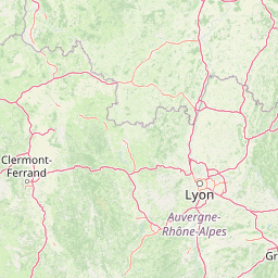
Map view of Réserve naturelle régionale du Puy de Marmant

Use this park location map to pinpoint Réserve naturelle régionale du Puy de Marmant in France, understand its exact geographic position, and read its mapped placement within the surrounding landscape more clearly.

Pigeon | © OpenStreetMap contributors

Location context for Réserve naturelle régionale du Puy de Marmant

Auvergne-Rhône-Alpes
Park atlas

Discover surrounding regional landscapes and compare adjacent volcanic terrain

Explore Protected Areas and Parks Near Réserve naturelle régionale du Puy de Marmant

Browse protected areas and natural reserves located near Réserve naturelle régionale du Puy de Marmant in central France. Comparing adjacent regional park geography provides deeper context into local volcanic formations and dry grassland ecosystems.
A soft watercolor painting of a wide, rolling landscape with green hills, pale mountain silhouettes in the background, and a faint reddish-brown foreground, presented on a white background.
Natural monumentAuvergne-Rhône-Alpes
About 3.6 km away#1 closest

Northwest

Chaîne des Puys - faille de Limagne: Mapping Volcanic and Tectonic Protected Landscapes

Geological exploration of the Auvergne-Rhône-Alpes volcanic chain

Spanning a rhythmic skyline of roughly eighty volcanoes, the Chaîne des Puys - faille de Limagne represents a premier site for studying continental rifting and volcanic landforms. This protected monument offers a clear view into the interplay between the ancient mountain basement, the massive Limagne fault, and the resulting volcanic edifices that define the regional identity of the Auvergne-Rhône-Alpes area.

Area
242.23 km²
Established
2018
Relief
Mountain
Climate
Temperate
Nature reservePuy-de-Dôme
About 24 km away#2 closest

Northwest

Réserve naturelle régionale des cheires et grottes de Volvic: Volcanic Landscapes and Bat Habitats

A regional nature reserve within the Puy-de-Dôme volcanic terrain

This protected area captures the geological signature of the Puy de la Nugère, where trachy-andésite lava flows form a stark surface landscape known as cheires. Beneath these flows, an extensive network of abandoned quarries provides stable cavities for diverse bat species, creating a dual-layered ecological site within the Chaîne des Puys.

Area
0.613 km²
Established
2014
IUCN
IV
Visitors
100K annual
A soft watercolor painting depicting rolling green hills and distant faint mountains under a light sky.
Nature reservePuy-de-Dôme
About 32 km away#3 closest

South

Réserve naturelle nationale du rocher de la Jaquette Protected Area and Volcanic Landscape

Explore rocky cliffs and rare entomological habitats in the Puy-de-Dôme region.

Situated on the flanks of a volcanic outcrop above the Rentières valley, this nature reserve protects a diverse habitat mosaic within the Massif Central. The site provides essential breeding grounds for protected raptors and represents one of the most significant insect sites in central France, offering a clear view into regional volcanic ecology and mountain-valley geography.

Area
0.362 km²
Established
1976
IUCN
IV
Relief
Mountain
A soft watercolor painting of a rolling landscape with green fields, distant purple hills, and patches of yellow and pink vegetation.
Nature reserveAuvergne-Rhône-Alpes
About 50 km away#4 closest

East

Réserve naturelle régionale des Jasseries de Colleigne Protected Area and Landscape Atlas

High-altitude moorlands and glacial geography in the Monts du Forez

This regional nature reserve provides a critical look at the Hautes Chaumes du Forez, an upland plateau in the Massif Central characterized by open grasslands and peat bogs. The site serves as a vital case study for the conservation of rare montane habitats maintained through traditional pastoral farming practices. Map the glacial Chorsin valley and explore the diverse botanical landscape contained within these protected high-altitude boundaries.

Area
2.85 km²
Established
1985
IUCN
IV
Relief
Mountain
Watercolor painting of a soft, hazy mountain landscape with rolling green fields and a distant forest, set against a light, warm, pale background.
Nature reserveAuvergne-Rhône-Alpes
About 57 km away#5 closest

Southwest

Réserve naturelle régionale des tourbières du Jolan et de la Gazelle: Geographic Overview

A vital wetland protected area in the Auvergne volcanic highlands.

Located in the Cantal department, the Réserve naturelle régionale des tourbières du Jolan et de la Gazelle features a unique collection of peatland habitats, trembling mires, and acidic grasslands. This area sits within the broader volcanic terrain of the Parc naturel régional des Volcans d'Auvergne, offering a protected catchment for diverse marshland flora and fauna.

Area
1.558 km²
Established
2018
IUCN
IV
Relief
Highland
Nature reserveAuvergne-Rhône-Alpes
About 63 km away#6 closest

Southeast

Réserve naturelle régionale du lac de Malaguet: Regional Nature Reserve and Wetland Atlas

Mapped protected landscapes in Haute-Loire, Auvergne-Rhône-Alpes

This protected area centers on a 14th-century artificial lake that now functions as a rich ecological sanctuary. Explore the confluence of medieval water infrastructure, riparian forests, and meadow zones that support diverse upland fauna. The site offers a clear example of long-term landscape transformation from industrial utility to a protected biodiversity refuge within the eastern Massif Central.

Area
0.542 km²
Established
2014
IUCN
IV
Relief
Upland
A soft, horizontal watercolor painting showing a meandering river winding through lush green riverbanks, with distant rolling hills against a white background.
Nature reserveAllier
About 76 km away#7 closest

North

Réserve naturelle nationale du val d'Allier Protected Area and River Corridor Map

Alluvial landscape and floodplain geography in central France

The Réserve naturelle nationale du val d'Allier encompasses a mosaic of gravel bars, islands, and side channels shaped by natural river dynamism. This protected expanse showcases a complete riparian forest sequence, providing a rare example of a largely untamed river floodplain preserved for its ongoing geomorphic activity.

Area
14.5 km²
Established
1994
IUCN
IV
Relief
Lowland
A horizontal watercolor painting showing a soft, stylized river winding through green hills and forests.
Regional parkAuvergne-Rhône-Alpes
About 88 km away#8 closest

East

Réserve naturelle régionale des gorges de la Loire: Landscape and Protected Area Geography

Regional nature reserve in the Auvergne-Rhône-Alpes landscape.

The Réserve naturelle régionale des gorges de la Loire protects a rugged stretch of the Loire River valley in the eastern Massif Central. Discover the geographic mosaic of rocky outcrops, shrubby heaths, and woodland slopes that define this protected area, and see how the terrain shapes its distinct biodiversity and river corridor boundaries.

Area
3.55 km²
Established
1988
IUCN
IV
Relief
Upland

Common questions about visiting, size, designation, and location context for Réserve naturelle régionale du Puy de Marmant

Réserve naturelle régionale du Puy de Marmant FAQs for park facts, access, geography, and protected area context

Find quick answers about Réserve naturelle régionale du Puy de Marmant, including protected-area facts, park geography, trail and visitor context, and how the park fits into its surrounding country and regional landscape.
MoriAtlas Explorer

Continue Your Protected Areas Search Across the Global Atlas

Deepen your exploration by continuing the structured search for national parks and protected areas worldwide. Utilize the comprehensive filtering capabilities to compare different conservation landscapes and refine your understanding of global park geography. Discover more about the distribution and characteristics of protected natural areas.

Global natural geography