
Mori Atlas logo
Nature reserveRéserve naturelle régionale du site des carrières de Tercis-les-Bains

A critical geological reference site featuring the Campanian-Maastrichtian boundary and ancient fossil sequences

Réserve naturelle régionale du site des carrières de Tercis-les-Bains Protected Area Geography

(Réserve naturelle régionale du site des carrières de Tercis-les-Bains (RNR287))

Located in the Nouvelle-Aquitaine region of France, this protected nature reserve preserves an exceptional sequence of limestone and marl exposures within former quarry landscapes. The site serves as the international stratotype for the Campanian-Maastrichtian boundary, offering researchers a continuous window into Cretaceous biological and environmental conditions. Beyond its scientific significance, the area documents a deep history of Paleolithic human activity along the Adour river corridor.

geological reservestratotype siteCretaceous fossilsCampanian-Maastrichtian boundaryabandoned quarrylimestone exposures
A digital illustration of a terraced limestone quarry surrounded by coniferous and deciduous trees under a soft, golden sunrise sky.

Réserve naturelle régionale du site des carrières de Tercis-les-Bains

Nature reserve

Park overview

Structured park overview, official facts, and landscape profile for Réserve naturelle régionale du site des carrières de Tercis-les-Bains

Réserve naturelle régionale du site des carrières de Tercis-les-Bains park facts, protected area profile, and essential visitor context

Review the core facts for Réserve naturelle régionale du site des carrières de Tercis-les-Bains, including designation, size, terrain, visitor scale, habitats, and operating context in one park-focused overview.

About Réserve naturelle régionale du site des carrières de Tercis-les-Bains

The Réserve naturelle régionale du site des carrières de Tercis-les-Bains is a French regional natural reserve dedicated almost entirely to geological heritage. Located in the Landes department of Nouvelle-Aquitaine, northwest of the village of Tercis-les-Bains, the reserve occupies the site of former industrial quarries that once supplied argillaceous limestone via a conveyor belt to the cement works of Angoumé on the opposite bank of the Adour. Mining operations ceased in 1993, and the site was acquired by the commune, setting the stage for its later protection.

The reserve's principal scientific value rests on its Cretaceous exposures. The quarries sit within the 'Ride de Tercis,' a faulted anticlinal ridge associated with underlying Triassic salt diapirism. This structural setting has produced outcrops spanning a broad interval of the late Cretaceous, from the Cenomanian up through the Maastrichtian, with additional early Paleocene (Danian) strata visible along the nearby 'Mur de Bédat' facing the Adour. The most studied interval is the Campanian-Maastrichtian transition, which is continuously exposed across more than 250 meters of alternating limestone and marl layers.

In 1995, the site was proposed as the global stratotype for the Campanian-Maastrichtian boundary at the Brussels Cretaceous Stratigraphy Congress. The reserve was formally classified two decades later, on 6 July 2015, as a regional nature reserve under the French RNR framework. Today it functions as an outdoor reference section for stratigraphers, paleontologists, and students, with the precise position of the boundary marked on site by a commemorative plaque.

Although small in area and primarily geological in focus, the reserve also encompasses ecological and cultural dimensions. The former quarry walls, reclaimed nature, and riverside habitat support localized biodiversity, while the surrounding landscape retains traces of much older human presence, including Paleolithic activity and Gravettian lithic production documented by archaeological research.

Quick facts and research context for Réserve naturelle régionale du site des carrières de Tercis-les-Bains

The reserve is a small regional protected area of roughly 45 hectares in the Landes department of Nouvelle-Aquitaine, in southwestern France. It is classified as IUCN Category IV (habitat/species management area) and is registered in the World Database on Protected Areas under the identifier 555597286. Created on 6 July 2015, the reserve encompasses disused quarries and a small section of the public fluvial domain along the Adour river.

Its core significance lies in geology rather than in biodiversity: the site preserves the global stratotype reference for the Campanian-Maastrichtian boundary, a key transition within the upper Cretaceous. The exposed sequence contains alternating limestone and marl layers documented across more than 250 meters of section, with a documented paleontological richness surpassing 900 fossil species.

Protection and recognition

Documented terrestrial protection metrics and official conservation status records

Protection Status and International Recognition for Réserve naturelle régionale du site des carrières de Tercis-les-Bains

Comprehensive protected area data details the terrestrial protection status and administrative framework established for Réserve naturelle régionale du site des carrières de Tercis-les-Bains. Structured conservation metrics outline the recorded management scope and official database identifiers for regional geographic analysis.

Protection details

Protection scope
Terrestrial
WDPA ID
555597286
Park context

Deeper park guide and search-rich context for Réserve naturelle régionale du site des carrières de Tercis-les-Bains

Réserve naturelle régionale du site des carrières de Tercis-les-Bains history, landscape, wildlife, and travel context

Explore Réserve naturelle régionale du site des carrières de Tercis-les-Bains through its history, landscape character, ecosystems, wildlife, conservation priorities, cultural context, and seasonal travel timing in a structured park guide built for atlas discovery and search intent.

Why Réserve naturelle régionale du site des carrières de Tercis-les-Bains stands out

The reserve is best known internationally for hosting the stratotype of the Campanian-Maastrichtian boundary, the global geological reference point separating two stages of the late Cretaceous period. This makes the former quarry a cornerstone site for stratigraphy, paleontology, and the study of Earth's geological timescale. It is also recognized for the exceptional density and continuity of its Cretaceous fossil record. The exposure preserves hundreds of meters of well-dated sedimentary layers, offering researchers a rare continuous window into the biological and environmental conditions of the late Cretaceous, including associated features such as the salt-driven structural geology of the Tercis Ridge and the Paleocene-aged 'Mur de Bédat' outcrop along the Adour.
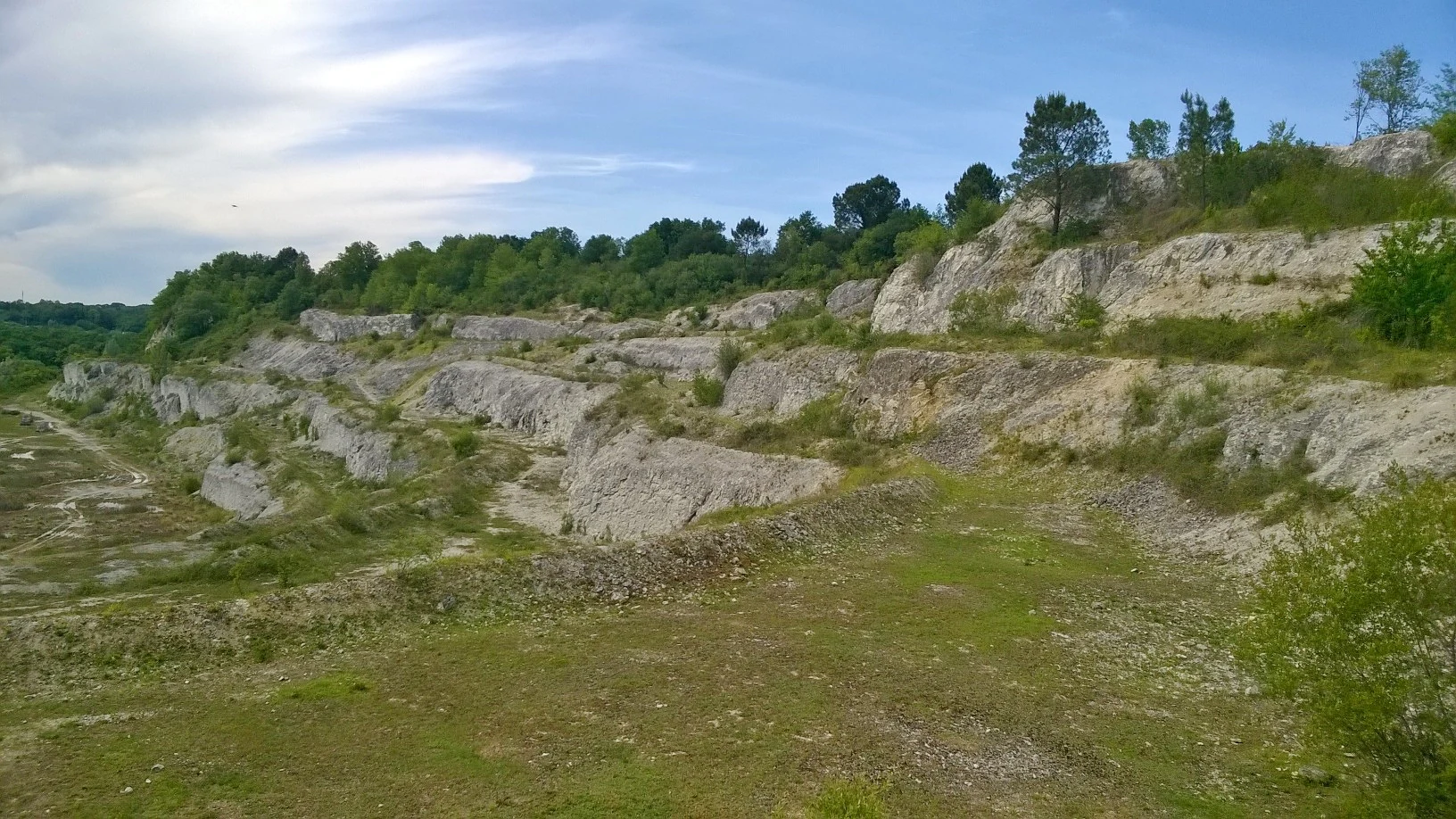
A wide, eye-level view of an abandoned, terraced limestone quarry showing exposed white rock layers, sparse grass, and scrubby vegetation against a blue sky.
The former quarry at the Réserve naturelle régionale du site des carrières de Tercis-les-Bains.

Réserve naturelle régionale du site des carrières de Tercis-les-Bains history and protected-area timeline

The reserve's history begins long before its formal protection. The site shows evidence of human activity dating back to the Paleolithic, and subsequent Gravettian-era occupants are known to have produced lithic armatures at Tercis, a topic addressed in dedicated archaeological studies of the site's prehistoric workshop.

In the modern era, the area was developed as an industrial quarry by the Société des Ciments Français. Argillaceous limestone extracted here was transported across the Adour by conveyor belt to supply the cement plant at Angoumé. Quarrying continued through much of the twentieth century before ceasing in 1993, at which point the commune of Tercis-les-Bains acquired the site.

Two decades later, the site received formal protection. In 1995, it was proposed at the Brussels Cretaceous Stratigraphy Congress as a candidate stratotype for the Campanian-Maastrichtian boundary, beginning its recognition within the international stratigraphic community. On 6 July 2015, the site was officially classified as a Réserve naturelle régionale, consolidating its transition from industrial quarry to protected scientific and natural heritage site.

Réserve naturelle régionale du site des carrières de Tercis-les-Bains landscape and geographic character

The landscape of the reserve is shaped by its geological past and its industrial past. The terraced walls of the former quarry cut sharply into the hillside, exposing layered sedimentary rock that would otherwise remain hidden beneath vegetation and soil. These artificial cliffs and benches form the visual signature of the site, viewed against the wooded slopes of the surrounding Landes countryside and the river corridor of the Adour.

Structurally, the reserve lies within the 'Ride de Tercis,' a faulted anticlinal ridge associated with deeper Triassic salt movements. The result is an unusual local relief in which older Cretaceous and even Paleocene strata have been brought toward the surface, creating exposure that geologists prize but that gives the area a distinctive, almost excavated topography. Along the riverbank, the 'Mur de Bédat' adds another dramatic vertical face of rock, displaying early Paleocene sediments directly above the older Cretaceous sequence.

Réserve naturelle régionale du site des carrières de Tercis-les-Bains ecosystems, habitats, and plant life

Although the reserve is best known for its geology, its ecological character is shaped by the interplay between abandoned quarry, recovering vegetation, and the Adour river corridor. The quarry benches and slopes have been left to recolonize naturally, generating a mosaic of open rocky habitats, scrub, and pioneer woodland that contrasts with the surrounding Landes forest landscape.

The small portion of the reserve that extends into the public fluvial domain of the Adour adds a riparian dimension to the site's nature. Together, these features create a transitional environment where exposed rock, regenerating vegetation, and riverside habitat meet, supporting a localized but distinctive set of ecological conditions for the region.

Réserve naturelle régionale du site des carrières de Tercis-les-Bains wildlife and species highlights

The reserve's specific wildlife profile is shaped primarily by its mosaic of rocky outcrops, regenerating scrub, and riverside habitat along the Adour rather than by extensive natural forest cover. The exposed quarry walls, fallow benches, and river-edge zones create microhabitats that host fauna adapted to open, mineral-rich environments.

A formal biodiversity inventory for the reserve is not elaborated in the available source material, so detailed species lists are not provided here. The site's ecological value is best understood in combination with its conservation and landscape context: a small protected area where habitat diversity arises from the meeting of geological exposure, plant recolonization, and riparian influence.

Réserve naturelle régionale du site des carrières de Tercis-les-Bains conservation status and protection priorities

The reserve's conservation significance lies primarily in the protection of geological heritage of international scientific importance. By classifying the former quarry as a regional nature reserve in 2015, France formally safeguarded the stratotype of the Campanian-Maastrichtian boundary, ensuring that this globally referenced geological section remains available for ongoing stratigraphic and paleontological research.

Classified under IUCN Category IV, the reserve operates within a habitat and species management framework, even though its central focus is the preservation of an in-situ geological record. The protection also extends to the broader site context, including part of the public fluvial domain along the Adour, allowing integrated management of rock exposures, reclaimed quarry habitats, and riverbank environments. The reserve thus occupies a distinctive niche within the French regional nature reserve network by prioritizing stratigraphic integrity and scientific access alongside ecological and landscape values.

Réserve naturelle régionale du site des carrières de Tercis-les-Bains cultural meaning and human context

Cultural context at the reserve is unusually long and layered for such a small protected area. Human presence at the site extends back to the Paleolithic, and the area has been the subject of Gravettian-era archaeological research focused on lithic knapping and the production of stone armatures. This prehistoric dimension gives the reserve a heritage value that overlaps with, but extends beyond, its geological significance.

In the more recent past, the site's industrial use under the Société des Ciments Français shaped both the local economy and the visible character of the quarry terraces, transporter routes, and former extraction zones. Once operations ceased in 1993, the transition to municipal and then regional natural reserve status reflected a deliberate local and regional choice to convert an industrial landscape into a space for science, education, and heritage.

Top sights and standout views in Réserve naturelle régionale du site des carrières de Tercis-les-Bains

Among the reserve's standout features is the global Campanian-Maastrichtian stratotype, a defining reference for late Cretaceous stratigraphy, physically marked on the quarry wall. The site's continuous sedimentary exposure and its documented record of over 900 fossil species place it among the most important Cretaceous reference localities in Europe.

Other highlights include the dramatic quarry terraces of the former limestone extraction site, the structural complexity of the underlying Tercis anticlinal ridge and its associated salt tectonics, and the Paleocene 'Mur de Bédat' outcrop along the Adour. Layered on top of these geological features is a much older human story, with the reserve preserving traces of Paleolithic and Gravettian activity that connect the deep time of the Cretaceous to the more recent history of human occupation in southwestern France.

Best time to visit Réserve naturelle régionale du site des carrières de Tercis-les-Bains

The reserve's appeal is largely geological and scientific rather than seasonal, so timing is more a matter of comfort and accessibility than of dramatic seasonal transformation. Spring and early autumn typically offer milder weather for outdoor fieldwork or guided visits along the quarry terraces and the Adour riverbank, when vegetation is active but heat and tourist congestion are lower than in mid-summer.

Winter visits are also feasible for those interested in seeing the rock exposures with minimal vegetation cover, which can help highlight the layered stratigraphy of the quarry walls. Those planning a research or educational visit should generally confirm current access arrangements in advance, as the reserve is managed as a protected scientific site rather than as a mass tourism destination.
Monthly climate preview

Long-term temperature and precipitation records measured at a representative coordinate

Climate Normals and Weather by Month for Réserve naturelle régionale du site des carrières de Tercis-les-Bains

Representative baseline measurements show average monthly temperatures ranging from 6.97 °C to 21.57 °C alongside sustained annual precipitation patterns. Detailed monthly breakdowns provide deeper analytical insight into long-term climate normals across the protected area.
Annual mean14 °C
7 °C22 °C
Jan
Feb
Mar10°
Apr12°
May15°
Jun18°
Jul21°
Aug22°
Sep19°
Oct15°
Nov10°
Dec
Warmest month
August

21.6 °C

Coolest month
January

7 °C

Wettest month
November

4.7 mm/day

Driest month
July

1.8 mm/day

Park location guide

Geography guide, regional context, and park location map for Réserve naturelle régionale du site des carrières de Tercis-les-Bains

Réserve naturelle régionale du site des carrières de Tercis-les-Bains park geography, regions, and map view in France

Understand where Réserve naturelle régionale du site des carrières de Tercis-les-Bains sits in France through a broader geographic reading of the surrounding landscape, nearby location context, and its mapped position within the national park landscape.

How Réserve naturelle régionale du site des carrières de Tercis-les-Bains fits into France

France is a unitary semi-presidential republic and one of the world's largest economies. It borders Belgium, Luxembourg, Germany, Switzerland, Italy, Monaco, Andorra, and Spain, with a maritime border to the United Kingdom. The country is known for its cultural influence, art, cuisine, and political history spanning centuries.

Wider geography shaping Réserve naturelle régionale du site des carrières de Tercis-les-Bains in France

France is located in Western Europe. Metropolitan France extends from the Rhine to the Atlantic Ocean and from the Mediterranean Sea to the English Channel and North Sea. The country borders Belgium, Luxembourg, Germany, Switzerland, Italy, Monaco, Andorra, Spain, and has a maritime border with the United Kingdom.

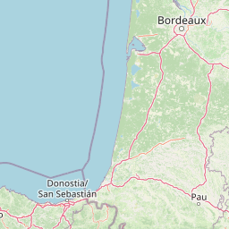
Map view of Réserve naturelle régionale du site des carrières de Tercis-les-Bains

Use this park location map to pinpoint Réserve naturelle régionale du site des carrières de Tercis-les-Bains in France, understand its exact geographic position, and read its mapped placement within the surrounding landscape more clearly.

Pigeon | © OpenStreetMap contributors

Location context for Réserve naturelle régionale du site des carrières de Tercis-les-Bains

Nouvelle-Aquitaine

Examine the exposed limestone terraces, geological formations, and protected quarry terrain.

Visualizing Réserve naturelle régionale du site des carrières de Tercis-les-Bains Photos and Landscapes

Visual records capture the distinctive terraced walls, layered sedimentary strata, and excavated topography of Réserve naturelle régionale du site des carrières de Tercis-les-Bains. Photographic documentation reveals the physical scale of the protected Cretaceous outcrops, the Adour river corridor, and the surrounding Landes landscape.

A wide, eye-level view of an abandoned, terraced limestone quarry showing exposed white rock layers, sparse grass, and scrubby vegetation against a blue sky.

Park atlas

Compare regional protected landscapes and geological reserves across southwest France

Explore Protected Areas and Parks Near Réserve naturelle régionale du site des carrières de Tercis-les-Bains

Browsing other protected areas near Réserve naturelle régionale du site des carrières de Tercis-les-Bains reveals the broader geological and ecological context of the Landes department. Comparing these neighboring natural reserves helps trace the regional spread of protected terrain across southwestern France.
Nature reserveNouvelle-Aquitaine
About 44 km away#1 closest

Southwest

Réserve naturelle régionale d'Errota Handia: Protected Wetland and Basque Geographic Atlas

Examining the ecological terrain of a historic French millpond reserve

Explore the structured geography of Réserve naturelle régionale d'Errota Handia, a compact but ecologically significant nature reserve in the Pyrénées-Atlantiques. This resource provides a detailed look at the park boundaries, wetland-woodland mosaic, and the historic hydraulic infrastructure that defines this unique Basque landscape, offering an essential perspective for understanding regional conservation in southwestern France.

Area
0.095 km²
Established
2001
IUCN
IV
National parkHautes-Pyrénées
About 94 km away#2 closest

Southeast

Pyrénées National Park: Protected Landscape & Transboundary Protected Area Atlas

Discover Hautes-Pyrénées' dramatic glacial terrain and alpine environments.

Pyrénées National Park is a significant protected area in France's Hautes-Pyrénées department, renowned for its dramatic glacial cirques, high-altitude lakes, and extensive mountain landscapes. Established as a national park, it offers rich geographic context for atlas exploration, showcasing millions of years of geological formation shaped by tectonic uplift and glacial carving. This park is also notable for its transboundary conservation efforts with Spain, contributing to a broader protected region. Explore its unique terrain, from towering limestone formations to alpine meadows, and understand its place within the Pyrenean mountain range.

Area
458 km²
Established
1967
IUCN
II
Relief
Mountain
A watercolor illustration of rolling mountain ranges and stylized forest patches in soft green and earth tones against a pale background.
Nature reserveOccitanie
About 105 km away#3 closest

Southeast

Réserve naturelle régionale du massif du Pibeste-Aoulhet: Mountain Reserve Atlas

Regional protected landscape mapping in the French Pyrenees

Spanning over 5,000 hectares in the Occitanie region, the Réserve naturelle régionale du massif du Pibeste-Aoulhet serves as a critical biological corridor. This detailed record examines the massif's varied elevations, from lower broadleaf forests to high-altitude rocky cliffs, highlighting its status as one of the largest regional nature reserves in France.

Area
51.103 km²
Established
2012
IUCN
IV
Relief
Mountain
Nature reservePyrénées-Atlantiques
About 106 km away#4 closest

Southeast

Vallée du Soussouéou Protected Nature Reserve: Geographic Atlas and Mountain Terrain

A roadless glacial valley in the French Pyrénées-Atlantiques

Vallée du Soussouéou offers a rare glimpse into a roadless Pyrenean landscape. This protected area features a classic glacial U-shaped valley, significant peatland ecosystems, and diverse alpine habitats that support Pyrenean fauna. As a quiet extension of the ecological network in the Western Pyrenees, the valley remains an important site for understanding mountain geography and glacial geomorphology in southwestern France.

Area
45.39 km²
Established
1995
Relief
Mountain
Scope
Terrestrial
Nature reserveGironde
About 115 km away#5 closest

North

Réservoirs de Piraillan Nature Reserve: Mapping the Coastal Ecology of the Cap Ferret Peninsula

A protected mosaic of saltwater basins and pine-forested islets in Gironde.

Explore the structured geography of Réservoirs de Piraillan, a forty-hectare classified natural reserve situated on the Cap Ferret peninsula in southwestern France. This site offers a rare contrast between historical fish reservoirs and dense maritime pine forest, providing a protected habitat for diverse bird and insect populations adjacent to the Bassin d'Arcachon. Understand the interplay between these saltwater pools and the wider coastal terrain of the Gironde department through detailed mapping and landscape data.

Area
0.4 km²
Established
1943
Relief
Lowland
Climate
Mediterranean
Nature reserveNouvelle-Aquitaine
About 118 km away#6 closest

North

Réserve naturelle nationale géologique de Saucats et la Brède: Geological Nature Reserve Atlas

Protected strata and Miocene fossil landscapes in Nouvelle-Aquitaine

This protected area serves as a primary European reference site for Cenozoic geology. It features distinct Miocene marine sand outcrops, fossil-rich faluns, and stream-cut sections that reveal the complex history of the Aquitaine Basin across multiple geographic sectors.

Area
0.755 km²
Established
1982
IUCN
III
Biosphere reserveBasque Country
About 124 km away#7 closest

West

Reserva de la biosfera de Urdaibai: Protected Coastal and Estuarine Geographic Atlas

Mapping wetlands, forests, and cliffs in the Basque Country

Explore the complex terrain of Reserva de la biosfera de Urdaibai, spanning the tidal Oka estuary to the peaks of Mount Oiz. This protected landscape is defined by its vast saltmarshes, Cantabrian oak forests, and dramatic coastal cliffs that anchor the natural geography of the Basque Country.

Area
224.52 km²
Established
1984
Relief
Mixed relief
Climate
Temperate
Watercolor painting showing a mountain range with a winding river through a valley
National parkSpain
About 139 km away#8 closest

Southeast

Ordesa y Monte Perdido National Park: Glacial Terrain and Pyrenean Protected Landscape

Explore its dramatic valleys, cliffs, and alpine geography.

Ordesa y Monte Perdido National Park is a critical protected area within the Pyrenean geography, defined by its spectacular glacial valleys, towering limestone massifs, and unique karst formations. As a National Park and UNESCO World Heritage Site, it offers a rich environment for exploring mapped terrain and understanding the interplay of geology and high-alpine ecosystems. Delve into the mapped boundaries and distinct landscape features that characterize this significant protected landscape.

Area
156.08 km²
Established
1918
IUCN
II
Relief
Mountain

Common questions about visiting, size, designation, and location context for Réserve naturelle régionale du site des carrières de Tercis-les-Bains

Réserve naturelle régionale du site des carrières de Tercis-les-Bains FAQs for park facts, access, geography, and protected area context

Find quick answers about Réserve naturelle régionale du site des carrières de Tercis-les-Bains, including protected-area facts, park geography, trail and visitor context, and how the park fits into its surrounding country and regional landscape.
MoriAtlas Explorer

Continue Your Protected Areas Search Across the Global Atlas

Deepen your exploration by continuing the structured search for national parks and protected areas worldwide. Utilize the comprehensive filtering capabilities to compare different conservation landscapes and refine your understanding of global park geography. Discover more about the distribution and characteristics of protected natural areas.

Global natural geography