Mori Atlas logo
Nature reserveRéserve naturelle régionale du val de Loire Bourbonnais

Mapping the Loire riverine meanders and alluvial floodplains within the Bourbonnais countryside

Réserve naturelle régionale du val de Loire Bourbonnais Protected Landscape and Geography

The Réserve naturelle régionale du val de Loire Bourbonnais protects a dynamic section of the Loire River and its surrounding floodplain habitat within the Allier department. This regional natural reserve encompasses the notable méandre des Germains, showcasing active river geomorphology and sediment processes. Discover the terrain of this protected corridor where alluvial meadows and riparian woodlands define the character of the Bourbonnais landscape.

regional natural reserveLoire Riverriverine habitatfloodplainriver meanderconservation experimentation

Réserve naturelle régionale du val de Loire Bourbonnais

Nature reserve

Park overview

Structured park overview, official facts, and landscape profile for Réserve naturelle régionale du val de Loire Bourbonnais

Réserve naturelle régionale du val de Loire Bourbonnais park facts, protected area profile, and essential visitor context

Review the core facts for Réserve naturelle régionale du val de Loire Bourbonnais, including designation, size, terrain, visitor scale, habitats, and operating context in one park-focused overview.

About Réserve naturelle régionale du val de Loire Bourbonnais

The Réserve naturelle régionale du val de Loire Bourbonnais occupies a meaningful position among France's regional natural reserves, focusing on the protection of a Loire river section and its immediate surroundings in the Allier department. The 308-hectare reserve lies within the Auvergne-Rhône-Alpes administrative region and straddles the communes of Garnat-sur-Engièvre and Saint-Martin-des-Lais, placing it firmly in the rural landscape of the Bourbonnais area, a region historically associated with the historic province of the same name.

The reserve's territory is defined by the Loire itself, Europe's last major undammed river, and by the alluvial floodplain that accompanies it. This setting gives the reserve a strongly riverine character, where the active channel of the river, its banks, islands, sandbars, and adjacent wetlands together create a mosaic of dynamic habitats. The presence of a notable meander, the méandre des Germains, gives the protected area distinctive geomorphological interest and provides opportunities to observe natural river processes such as erosion, sediment deposition, and shifting channels, which are increasingly rare on heavily regulated European rivers.

From an ecological standpoint, the reserve contributes to broader efforts in the Allier valley to maintain and restore the functionality of floodplain ecosystems. These ecosystems are known for their role in filtering water, supporting biodiversity, and reducing flood risk. The reserve's modest size is offset by its location within a wider working agricultural and pastoral landscape, allowing it to act as a refuge and stepping stone for species that depend on riverine and wetland conditions.

The reserve's identity is also tied to its management structure. The Conservatoire d'espaces naturels de l'Allier has been involved at the site since 2002, predating the formal classification of the reserve by more than a decade. This continuity has allowed for long-term experiments in habitat management and has positioned the reserve as a place where conservation practice and public education meet. The site is described as a lieu d'expérimentation et un lieu à valeur pédagogique, meaning it functions both as a laboratory for conservation approaches and as an educational setting where visitors and local communities can engage with wetland and river ecology.

For visitors and residents of the Allier department, the reserve represents a tangible local expression of regional natural heritage, complementing other efforts to maintain the Loire's status as one of Europe's most important large free-flowing rivers. While much of the detailed ecosystem information on the existing public documentation remains underdeveloped, the reserve's core significance is clear: it protects a representative segment of the Loire and its immediate floodplain in the Bourbonnais area and serves as a focal point for ongoing regional conservation.

Quick facts and research context for Réserve naturelle régionale du val de Loire Bourbonnais

The Réserve naturelle régionale du val de Loire Bourbonnais is designated as a regional natural reserve under French law and is classified as an IUCN Category IV protected area. It is situated in the Allier department in central France, covering approximately 308 hectares along the Loire River, with the territory spread across two communes: Garnat-sur-Engièvre and Saint-Martin-des-Lais.

The reserve was formally created by a deliberation of the Regional Council on 30 June 2015 and is managed by the Conservatoire d'espaces naturels de l'Allier, an organization that had been active on the site since 2002, particularly around the méandre des Germains. The reserve is referenced under code RNR299 and is registered in the World Database on Protected Areas.

Protection and recognition

Documented protection records, database identifiers, and official designation history.

Réserve Naturelle Régionale du Val de Loire Bourbonnais Protection Status

Examine the recorded protection status and official database references associated with Réserve naturelle régionale du val de Loire Bourbonnais. Designated records assemble verified administrative details and international tracking indicators for conservation analysis.

Protection details

WDPA ID
555597270
Park context

Deeper park guide and search-rich context for Réserve naturelle régionale du val de Loire Bourbonnais

Réserve naturelle régionale du val de Loire Bourbonnais history, landscape, wildlife, and travel context

Explore Réserve naturelle régionale du val de Loire Bourbonnais through its history, landscape character, ecosystems, wildlife, conservation priorities, cultural context, and seasonal travel timing in a structured park guide built for atlas discovery and search intent.

Why Réserve naturelle régionale du val de Loire Bourbonnais stands out

The reserve is best known for protecting a section of the Loire River and its associated floodplain habitats in the historic Bourbonnais region of central France. Its focal point is the méandre des Germains, a river meander that has been a focus of conservation attention by the local conservatoire since the early 2000s. As a regional natural reserve, it represents the kind of small-scale but locally significant protected area that safeguards a representative example of the Loire's dynamic riverine landscape, including the river channel itself and the surrounding alluvial formations that characterize this stretch of the upper Loire valley.

Réserve naturelle régionale du val de Loire Bourbonnais history and protected-area timeline

The history of the Réserve naturelle régionale du val de Loire Bourbonnais is rooted in the conservation efforts of the Conservatoire d'espaces naturels de l'Allier, which became active on the site as early as 2002. The conservatoire's early work centered on a particular area of the Loire known as the méandre des Germains, reflecting the growing recognition of the importance of preserving representative sections of the Loire's natural river dynamics.

This early involvement laid the groundwork for the formal establishment of the reserve, which was created by a deliberation of the Conseil régional on 30 June 2015. The decision reflected the regional council's intent to give lasting protection to a section of the Loire and to formalize the experimental and educational role that the conservatoire had been developing.

Since its classification, the reserve has been managed by the Conservatoire d'espaces naturels de l'Allier, continuing the trajectory of stewardship that began in the early 2000s and emphasizing the reserve's role as a site for conservation experimentation and public education within the Allier landscape.

Réserve naturelle régionale du val de Loire Bourbonnais landscape and geographic character

The landscape of the reserve is defined by the Loire River itself and the alluvial floodplain that accompanies it. As one of Europe's major undammed rivers, the Loire in this stretch exhibits natural dynamic processes, including meandering, bank erosion, sediment deposition, and the formation and reworking of gravel and sand bars. These processes create a constantly evolving physical setting that shapes both the visual character and the ecological value of the reserve.

The protected area includes the area known as the méandre des Germains, a clear example of the curving loops and oxbow-style formations typical of a freely meandering river. The meander gives the landscape a distinctive sinuous shape and represents a key geomorphological feature of interest within the reserve.

The surrounding terrain belongs to the Bourbonnais countryside, characterized by a mix of floodplain meadows, riparian woodland, agricultural land, and small rural settlements in communes such as Garnat-sur-Engièvre and Saint-Martin-des-Lais. The interplay between active river dynamics and traditional rural land use creates a layered landscape where natural processes and human land management coexist along a relatively narrow corridor of the upper Loire valley.

Réserve naturelle régionale du val de Loire Bourbonnais ecosystems, habitats, and plant life

The ecological character of the reserve is fundamentally riverine, centered on the Loire and its floodplain. The alluvial habitats present within the reserve represent the kind of dynamic ecosystems that develop along large free-flowing rivers, where periodic flooding, sediment turnover, and fluctuating water levels maintain a mosaic of conditions ranging from open gravel bars and sandbanks to riparian forests and wet meadows.

Such habitats are known for their importance in supporting biodiversity, particularly for species adapted to disturb-dependent or flood-influenced environments. Forested bands and shrubby riparian vegetation along the river corridor contribute structural diversity, while wet meadows and marshy zones within the broader floodplain provide additional habitat gradients.

The conservation interest of these habitats lies both in their intrinsic ecological value and in their role within the wider functioning of the Loire basin. Floodplain ecosystems along the Loire contribute to water quality regulation, groundwater recharge, and the natural moderation of flood events, while also serving as habitat for a range of plant and animal species. Although detailed species inventories are not yet well represented in the public sources available, the reserve's ecological significance is clearly tied to this combination of river dynamics and floodplain habitats.

Réserve naturelle régionale du val de Loire Bourbonnais wildlife and species highlights

The reserve's wildlife value is closely tied to its riverine and floodplain character. Habitats associated with the Loire, such as gravel bars, riverbanks, riparian woodland, and adjacent wet meadows, are known to support a variety of bird, fish, and invertebrate communities typical of large European river systems.

Migratory and resident bird species associated with river and wetland habitats would be expected to use this stretch of the Loire, particularly given the dynamic nature of the channel and the surrounding alluvial formations. The presence of varied microhabitats, from exposed sediment to vegetated banks, contributes to a structurally rich environment for fauna.

The reserve's role as a refuge for wildlife along the Allier stretch of the Loire is part of its broader conservation purpose, even though detailed species-level information is limited in currently available sources.

Réserve naturelle régionale du val de Loire Bourbonnais conservation status and protection priorities

From a conservation perspective, the reserve protects a segment of one of Europe's last major undammed rivers, along with the associated floodplain ecosystems that depend on the river's natural dynamics. The Loire's lack of major dams on its main channel makes such protected areas especially valuable for preserving river processes that have been lost elsewhere in Europe.

Classified by the International Union for Conservation of Nature as a Category IV protected area, which is the designation for habitat and species management areas, the reserve is part of France's system of regional natural reserves, which are established by regional councils to safeguard sites of regional ecological importance. The reserve is officially registered as RNR299 in French regional natural reserve numbering and appears in the World Database on Protected Areas.

The Conservatoire d'espaces naturels de l'Allier's long-term involvement at the site, beginning in 2002, reflects a sustained commitment to habitat management and the experimental development of conservation practices tailored to the local context. The reserve is explicitly conceived as both a site for testing conservation approaches and a place of public education, underscoring its role as a working conservation landscape rather than a strictly passive protected designation.

Réserve naturelle régionale du val de Loire Bourbonnais cultural meaning and human context

The reserve lies in the Bourbonnais region, a historic province in central France whose identity is closely tied to the Allier department and the upper Loire valley. The local cultural landscape reflects a long tradition of rural land use, with small river communes like Garnat-sur-Engièvre and Saint-Martin-des-Lais forming part of the traditional social and agricultural fabric of this part of France.

The Loire River itself carries deep cultural significance as one of the great rivers of France, embodying both natural heritage and centuries of human history along its banks. The reserve's location along a still predominantly free-flowing stretch of the Loire connects contemporary conservation work with this broader cultural and geographic heritage of the Bourbonnais area.

Top sights and standout views in Réserve naturelle régionale du val de Loire Bourbonnais

The reserve stands out for combining protection of a dynamic section of the Loire River with a strong regional management identity through the Conservatoire d'espaces naturels de l'Allier. Its central feature, the méandre des Germains, gives the reserve clear geomorphological character and illustrates natural river processes rarely preserved on this scale elsewhere in Europe.

Its experimental and educational role, established through more than a decade of conservatoire involvement before formal classification, also distinguishes the reserve as a place where conservation practice and public engagement with river ecology come together in a small but meaningful regional setting.

Best time to visit Réserve naturelle régionale du val de Loire Bourbonnais

Visiting the reserve is best undertaken during seasons when the riverine landscape is most accessible and visually expressive, generally late spring through early autumn, when water levels tend to be lower and the surrounding meadows and riparian vegetation are most active. Spring can highlight floodplain renewal and seasonal vegetation growth, while autumn offers quieter conditions and an emphasis on changing light along the river corridor.

Winter and early spring visits can be shaped by higher water levels on the Loire, which underscore the dynamic character of the river and may limit access to certain riverbank areas. Visitors should approach the reserve as a working conservation landscape rather than a fully equipped visitor destination.
Monthly climate preview

Long-term representative temperature and precipitation patterns across the year

Réserve naturelle régionale du val de Loire Bourbonnais Annual Climate Normals

Representative coordinates record measured monthly temperature swings from sub-zero winter minimums to warm summer maximums alongside steady daily precipitation rates. Examining the full twelve-month profile reveals complete long-term climate normals for the protected landscape.
Annual mean11 °C
2 °C21 °C
Jan
Feb
Mar
Apr10°
May14°
Jun18°
Jul21°
Aug21°
Sep16°
Oct11°
Nov
Dec
Warmest month
July

20.7 °C

Coolest month
January

2.2 °C

Wettest month
May

2.4 mm/day

Driest month
March

1.4 mm/day

Park location guide

Geography guide, regional context, and park location map for Réserve naturelle régionale du val de Loire Bourbonnais

Réserve naturelle régionale du val de Loire Bourbonnais park geography, regions, and map view in France

Understand where Réserve naturelle régionale du val de Loire Bourbonnais sits in France through a broader geographic reading of the surrounding landscape, nearby location context, and its mapped position within the national park landscape.

How Réserve naturelle régionale du val de Loire Bourbonnais fits into France

France is a unitary semi-presidential republic and one of the world's largest economies. It borders Belgium, Luxembourg, Germany, Switzerland, Italy, Monaco, Andorra, and Spain, with a maritime border to the United Kingdom. The country is known for its cultural influence, art, cuisine, and political history spanning centuries.

Wider geography shaping Réserve naturelle régionale du val de Loire Bourbonnais in France

France is located in Western Europe. Metropolitan France extends from the Rhine to the Atlantic Ocean and from the Mediterranean Sea to the English Channel and North Sea. The country borders Belgium, Luxembourg, Germany, Switzerland, Italy, Monaco, Andorra, Spain, and has a maritime border with the United Kingdom.

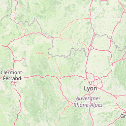
Map view of Réserve naturelle régionale du val de Loire Bourbonnais

Use this park location map to pinpoint Réserve naturelle régionale du val de Loire Bourbonnais in France, understand its exact geographic position, and read its mapped placement within the surrounding landscape more clearly.

Pigeon | © OpenStreetMap contributors

Location context for Réserve naturelle régionale du val de Loire Bourbonnais

Auvergne-Rhône-Alpes
Park atlas

Compare surrounding protected landscapes and regional river reserves in central France

Other Parks Near Réserve naturelle régionale du val de Loire Bourbonnais

Browse nearby protected areas and adjacent riverine landscapes connected to the upper Loire valley ecosystem. Comparing similar regional reserves provides a broader geographic perspective on alluvial floodplains and dynamic wetland habitats across the Bourbonnais countryside.
Watercolor painting of the Loire river showing trees along the banks and soft pink clouds in the background.
Nature reserveBourgogne-Franche-Comté
About 15 km away#1 closest

Northwest

Réserve naturelle régionale de la Loire bourguignonne: Regional Nature Reserve Map

Protected fluvial geography in Bourgogne-Franche-Comté

Located in the Nièvre department, this reserve protects an essential section of the Loire river. The landscape offers a rich mosaic of 31 natural habitats, featuring exposed gravel banks and riparian woodlands that support rare endemic flora and diverse ground-nesting bird populations.

Area
7.397 km²
Established
2015
IUCN
IV
Relief
Lowland
A soft, horizontal watercolor painting showing a meandering river winding through lush green riverbanks, with distant rolling hills against a white background.
Nature reserveAllier
About 30 km away#2 closest

Southwest

Réserve naturelle nationale du val d'Allier Protected Area and River Corridor Map

Alluvial landscape and floodplain geography in central France

The Réserve naturelle nationale du val d'Allier encompasses a mosaic of gravel bars, islands, and side channels shaped by natural river dynamism. This protected expanse showcases a complete riparian forest sequence, providing a rare example of a largely untamed river floodplain preserved for its ongoing geomorphic activity.

Area
14.5 km²
Established
1994
IUCN
IV
Relief
Lowland
A horizontal watercolor painting showing a small pond surrounded by soft green trees, grass, and a few small red flowers against a pale sky.
Nature reserveBourgogne-Franche-Comté
About 62 km away#3 closest

Northeast

Réserve naturelle régionale des tourbières du Morvan: A Geographic Study of Peatland Protection

Regional Nature Reserve in the Bourgogne-Franche-Comté landscape

This expansive network reserve protects twelve notable peatlands across the departments of Nièvre and Saône-et-Loire. From the rare raised bog at Champgazon to the peat-fringed ponds of Étang Taureau, the reserve acts as a critical conservation mosaic that maintains the ecological connectivity of diverse sphagnum habitats within the greater Morvan regional landscape.

Area
2.66 km²
Established
2015
IUCN
IV
Relief
Mountain
A horizontal watercolor painting showing a green landscape with a winding stream, patches of marshy water, and distant hills, with soft light and green trees on the sides.
Nature reserveBourgogne-Franche-Comté
About 65 km away#4 closest

Northwest

Réserve naturelle régionale des Mardelles de Prémery: Protected Wetland and Forest Geography

Mapping the peatland depressions of the Prémery forest

This nature reserve protects a rare assemblage of mardelles, shallow forest pools set within the Prémery state forest. The landscape serves as a vital ecological archive, with peat deposits documenting environmental changes over 15 millennia. Explore the unique hydrological and botanical features of this protected lowland habitat nestled in the heart of the Nièvre department.

Area
2.525 km²
Established
2015
IUCN
IV
Nature reserveAuvergne-Rhône-Alpes
About 83 km away#5 closest

West

Espace naturel sensible de la Vauvre Protected Wetland Reserve and Geographic Landscape

Mapping wetland conservation in the Allier department

Covering 46 hectares of reclaimed terrain, this protected nature reserve provides a critical sanctuary for birds and wetland species. The site functions as a documented mosaic of ponds and damp grasslands, offering a clear example of localized ecological restoration within the broader context of the Cher valley geography.

Area
0.46 km²
Established
1996
IUCN
IV
Relief
Lowland
A horizontal watercolor painting depicting a wide river valley with grassy banks and distant hills in soft pastel shades of green, yellow, and muted pink.
Nature reserveBourgogne-Franche-Comté
About 83 km away#6 closest

Northwest

Réserve naturelle nationale du val de Loire: Protected River Geography and Map

An active alluvial landscape in the French river corridor

The Réserve naturelle nationale du val de Loire preserves one of the most representative segments of a free-flowing river system in Europe. This protected corridor showcases an exceptionally active dynamic, featuring shifting sandbanks, calm backwaters, and diverse alluvial forests that define the valley floor. Learn about the geographic boundaries and the natural terrain that characterize this essential French nature reserve.

Area
14.54 km²
Established
1995
IUCN
IV
Relief
Lowland
A wide watercolor illustration showing a soft landscape with pink flowers on the left, green bushes and rocks on the right, and distant mountains across a misty valley.
Protected areaFrance
About 89 km away#7 closest

East

Site naturel protégé de la Boucherette: Protected Limestone Grasslands in Southern Burgundy

Calcareous habitat and botanical trail geography

Located in the Saône-et-Loire commune of Lugny, this 104-hectare protected area showcases a distinctive transition between limestone hills and the Saône valley. The site is recognized for its concentration of wild orchids and its integration of ecological conservation with the historical footprint of centuries-old stone quarrying and tile production.

Area
1.04 km²
Established
2000
Visitors
1K annual
Relief
Upland
A soft watercolor painting of a wide, rolling landscape with green hills, pale mountain silhouettes in the background, and a faint reddish-brown foreground, presented on a white background.
Natural monumentAuvergne-Rhône-Alpes
About 99 km away#8 closest

Southwest

Chaîne des Puys - faille de Limagne: Mapping Volcanic and Tectonic Protected Landscapes

Geological exploration of the Auvergne-Rhône-Alpes volcanic chain

Spanning a rhythmic skyline of roughly eighty volcanoes, the Chaîne des Puys - faille de Limagne represents a premier site for studying continental rifting and volcanic landforms. This protected monument offers a clear view into the interplay between the ancient mountain basement, the massive Limagne fault, and the resulting volcanic edifices that define the regional identity of the Auvergne-Rhône-Alpes area.

Area
242.23 km²
Established
2018
Relief
Mountain
Climate
Temperate

Common questions about visiting, size, designation, and location context for Réserve naturelle régionale du val de Loire Bourbonnais

Réserve naturelle régionale du val de Loire Bourbonnais FAQs for park facts, access, geography, and protected area context

Find quick answers about Réserve naturelle régionale du val de Loire Bourbonnais, including protected-area facts, park geography, trail and visitor context, and how the park fits into its surrounding country and regional landscape.
MoriAtlas Explorer

Continue Your Protected Areas Search Across the Global Atlas

Deepen your exploration by continuing the structured search for national parks and protected areas worldwide. Utilize the comprehensive filtering capabilities to compare different conservation landscapes and refine your understanding of global park geography. Discover more about the distribution and characteristics of protected natural areas.

Global natural geography