
Mori Atlas logo
Nature reserveRéserve naturelle régionale du vallon de Fontenelay

Mapping the marly grasslands and alkaline marshes of the Monts de Gy in Haute-Saône

Réserve naturelle régionale du vallon de Fontenelay: Protected Landscapes and Geography

The Réserve naturelle régionale du vallon de Fontenelay protects a specialized mosaic of marly calcareous grasslands and seepage-fed alkaline marshes within the Monts de Gy. This compact valley in the Bourgogne-Franche-Comté region serves as a vital habitat for diverse orchid species and rare wetland butterflies. By examining the local topography and soil characteristics, visitors can understand the interplay between limestone, marl, and water that defines this regional nature reserve.

regional nature reservemarly grasslandsalkaline marshseepage slopesorchidsbroadleaf forest
A flat-style digital illustration of a mountain valley with a waterfall, a winding path, a meadow, and coniferous forests, with stylized autumn leaves in the foreground.

Réserve naturelle régionale du vallon de Fontenelay

Nature reserve

Park overview

Structured park overview, official facts, and landscape profile for Réserve naturelle régionale du vallon de Fontenelay

Réserve naturelle régionale du vallon de Fontenelay park facts, protected area profile, and essential visitor context

Review the core facts for Réserve naturelle régionale du vallon de Fontenelay, including designation, size, terrain, visitor scale, habitats, and operating context in one park-focused overview.

About Réserve naturelle régionale du vallon de Fontenelay

The Réserve naturelle régionale du vallon de Fontenelay lies in the Haute-Saône department of Bourgogne-Franche-Comté, about 25 kilometers north of Besançon, between the communes of Bucey-lès-Gy and Montboillon in the Monts de Gy. Although it covers only around 41 hectares, the valley contains a striking diversity of habitats within a very small footprint, and the reserve has become a reference site for the conservation of marly grasslands and slope seepage wetlands in the region.

The land is located at the northern edge of the Fontenelay valley, on an east-facing slope threaded with seepage springs that feed a partly underground stream, the ruisseau des Merles. The valley sits within a much larger forested massif, and the reserve therefore reads as a clear ecological exception, an opening in the woodland where thin, impermeable marl layers have kept soil conditions unusually rich and moist. This has preserved a transitional landscape of dry and wet semi-open habitats that has been almost entirely lost from the surrounding farmed and forested countryside.

Ecologically, the reserve protects roughly 165 plant species, including about twenty orchid species, as well as various gentians, sedges, and other calcareous-marsh specialists. It also shelters around 57 bird species, twelve reptile, amphibian, and fish species, and a notable invertebrate community that includes several protected butterflies and dragonflies. The combination of lowland monts climate, calcareous-marl soils, and stable traditional land use, particularly extensive grazing, has shaped a site that is small but disproportionately rich for its area.

Since 2012 the reserve has been managed by the Conservatoire d'espaces naturels de Franche-Comté, following a transfer from the regional branch of France Nature Environnement. Management focuses on maintaining open habitat through light grazing and volunteer work parties, and on monitoring the rare species that justify the site's regional importance. The reserve exists alongside the regional ZNIEFF inventories that recognize both the valley itself and the broader Monts de Gy as areas of high ecological value.

Quick facts and research context for Réserve naturelle régionale du vallon de Fontenelay

The Réserve naturelle régionale du vallon de Fontenelay is a regional nature reserve located in the Haute-Saône department of Bourgogne-Franche-Comté, in eastern France. It lies about 25 kilometers north of Besançon, between the villages of Gy and Audeux, within the Monts de Gy.

Established by deliberation on 28 May 2010, the reserve covers roughly 41.6 hectares of valley terrain at an elevation of around 300 meters. It is classified as IUCN Category IV and is managed by the Conservatoire d'espaces naturels de Franche-Comté. The protected area sits within a larger ZNIEFF, and the surrounding landscape is dominated by broadleaf forest surrounding fragments of dry marly grassland and an alkaline slope marsh.

Protection and recognition

Review documented terrestrial protection scope and baseline designation records.

Protection Status and Designation History for Réserve naturelle régionale du vallon de Fontenelay

Terrestrial protection status records for Réserve naturelle régionale du vallon de Fontenelay establish a clear baseline designation from 2010. Official administrative tracking incorporates verified conservation metrics and global database identifiers for structured geographic analysis.

Protection details

Protection scope
Terrestrial
Designated year
2010
Transboundary protection
No
WDPA ID
555514368
Park context

Deeper park guide and search-rich context for Réserve naturelle régionale du vallon de Fontenelay

Réserve naturelle régionale du vallon de Fontenelay history, landscape, wildlife, and travel context

Explore Réserve naturelle régionale du vallon de Fontenelay through its history, landscape character, ecosystems, wildlife, conservation priorities, cultural context, and seasonal travel timing in a structured park guide built for atlas discovery and search intent.

Why Réserve naturelle régionale du vallon de Fontenelay stands out

The reserve is especially known for its compact but ecologically rich mosaic of marly calcareous grasslands, alkaline seepage marshes, and scattered broadleaf woodland on an east-facing slope. It is one of the few sites in Haute-Saône where marl-dependent orchid-rich grassland and a slope-fed alkaline marsh still coexist within a single small valley. The combination of dry calcareous soils, persistent surface seeps, and a partly underground stream creates habitat for unusual plant communities such as large stands of white cottongrass, along with marsh gentians, bee orchids, and the rare marsh helleborine. The site is also noted regionally for its population of the white-clawed crayfish in the small Merles stream.
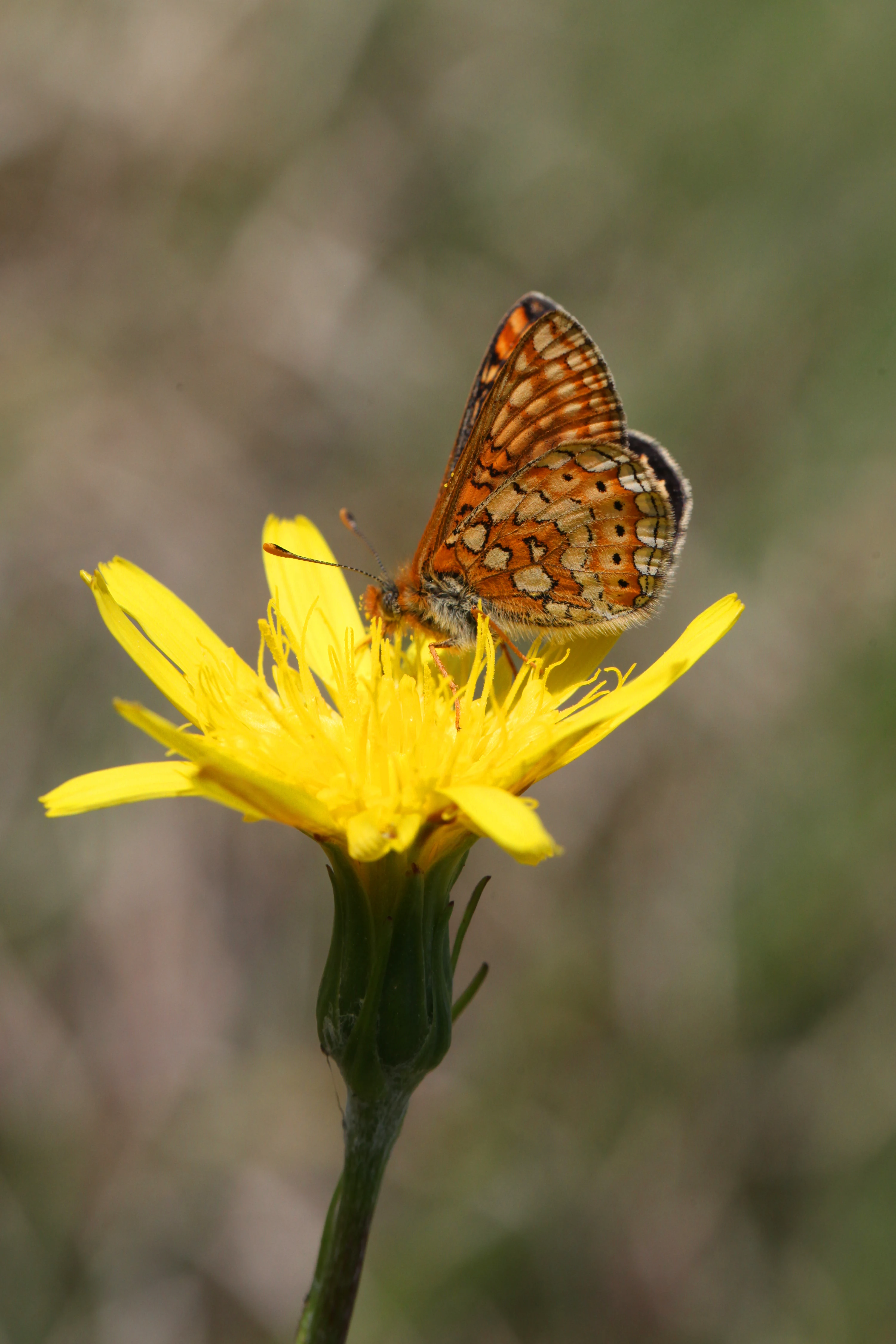
A close up view of an orange and brown checkered Marsh Fritillary butterfly resting on a bright yellow flower against a soft green blurred background.
A Marsh Fritillary butterfly perched on a yellow wildflower in the Réserve naturelle régionale du vallon de Fontenelay.

Réserve naturelle régionale du vallon de Fontenelay history and protected-area timeline

The land that now forms the reserve has long been used as a traditional mixed landscape of woodland, grassland, and marsh, sustained by extensive grazing on poor calcareous-marl soils unsuitable for cultivation. Until 2012 the site was owned and managed directly by the Fédération régionale de protection de la nature France Nature Environnement Franche-Comté, which organized volunteer work parties to maintain open habitat and monitor species.

In 2012 the federation transferred day-to-day management to the Conservatoire d'espaces naturels de Franche-Comté, which also drafted the formal management plan for the site. The reserve itself was officially classified as a Réserve naturelle régionale on 28 May 2010, by regional deliberation, for an initial renewable term of ten years. Its creation formalized the long-standing local commitment to keeping this unusual valley habitat in good conservation condition.

Réserve naturelle régionale du vallon de Fontenelay landscape and geographic character

The reserve occupies a short, narrow valley on the northern edge of the larger Fontenelay valley. The eastern slope that forms its core rises gently to a forested ridge, with the floor of the valley containing a small partly underground stream. Elevation across the site is modest, around 300 meters, and the terrain shows the influence of the surrounding Monts de Gy, a low limestone massif shaped by past forest cover and traditional rural land use.

Geologically, the Monts de Gy are formed of hard limestone, but the reserve sits on a thinner marl and limestone subsoil that is largely impermeable. This layer traps rainfall near the surface, where it re-emerges as diffuse seepage and feeds the marsh at the foot of the slope. The interplay between hard upland limestone, soft marl, and emergent groundwater has produced a landscape of small clearings, humid flushes, and scattered trees that is visually distinct from the dense forest that dominates most of the surrounding massif.
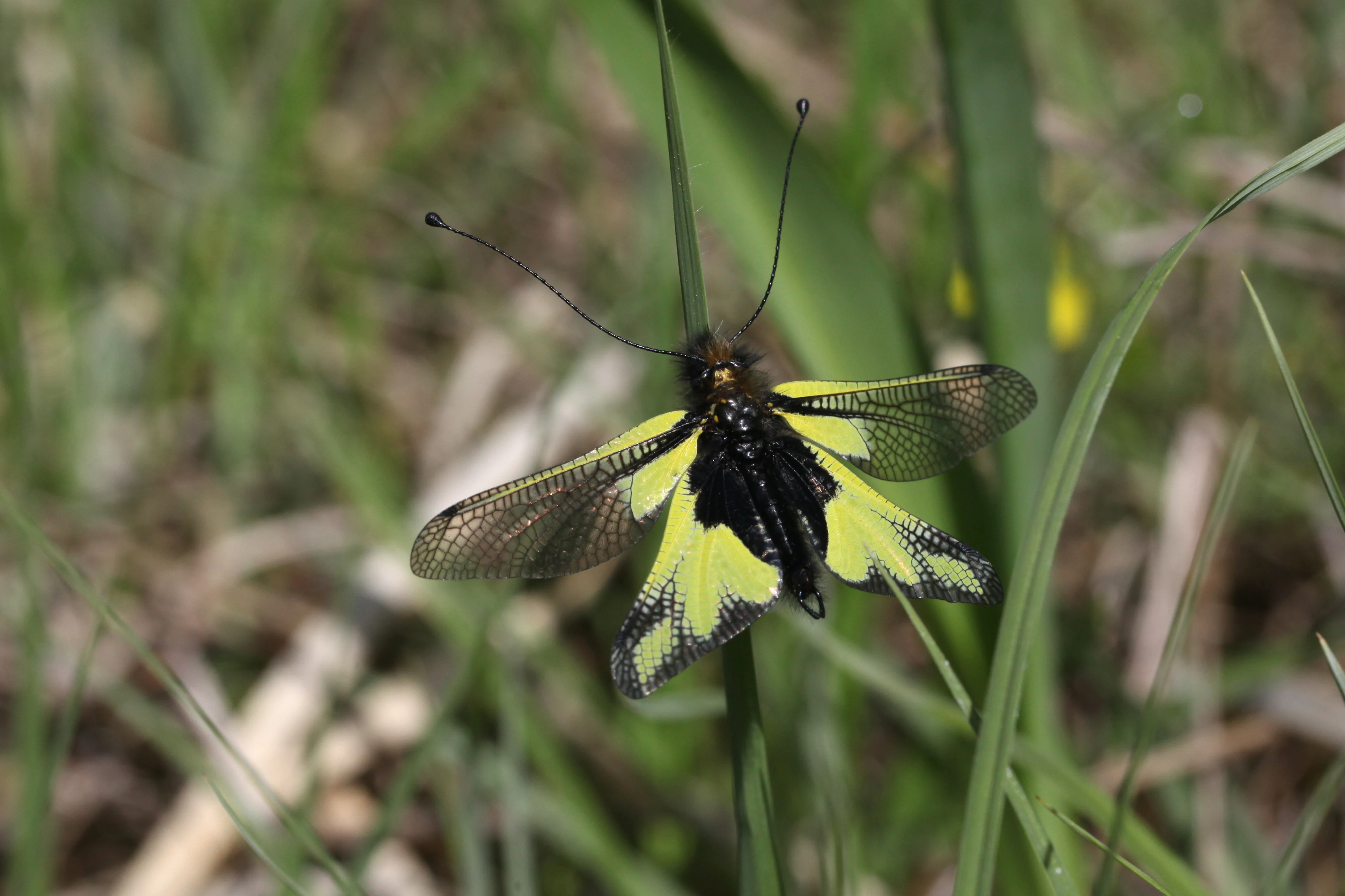
A close up view of an Ascalaphus libelloides owlfly with yellow and black patterned wings, perched on a thin green blade of grass.
An Ascalaphus libelloides resting on a blade of grass within the reserve.

Réserve naturelle régionale du vallon de Fontenelay ecosystems, habitats, and plant life

Ecologically, the reserve is defined by a tight mosaic of contrasting habitats packed into a very small area. The most distinctive communities are the marly grasslands on the upper slope, prized for orchids and other calcareous indicator species, and the alkaline slope marsh below, fed by permanent seepage and rich in cottongrass, gentians, and sedges. Between these extremes are patches of broadleaf woodland with scattered oak, rough meadows, and the partly subterranean ruisseau des Merles.

This juxtaposition of dry calcareous grassland and permanently wet alkaline marsh within one small valley is rare in Haute-Saône, and gives the site much of its conservation value. The reserve also includes transition zones, where scattered trees and shrubs create semi-open conditions that support species typical of both woodland and open ground. Vegetation patterns reflect soil chemistry and water movement rather than management alone, and the seepage lines form the ecological backbone of the site.

Approximately 165 plant species have been recorded, including around twenty orchid species such as the bee orchid and the marsh helleborine, as well as the adder's-tongue fern, fringed gentian, German gentian, yellow-wort, and the marsh sedge Carex hostiana. The flora reflects the unusual combination of calcareous and mildly saline or alkaline influence typical of marl habitats.
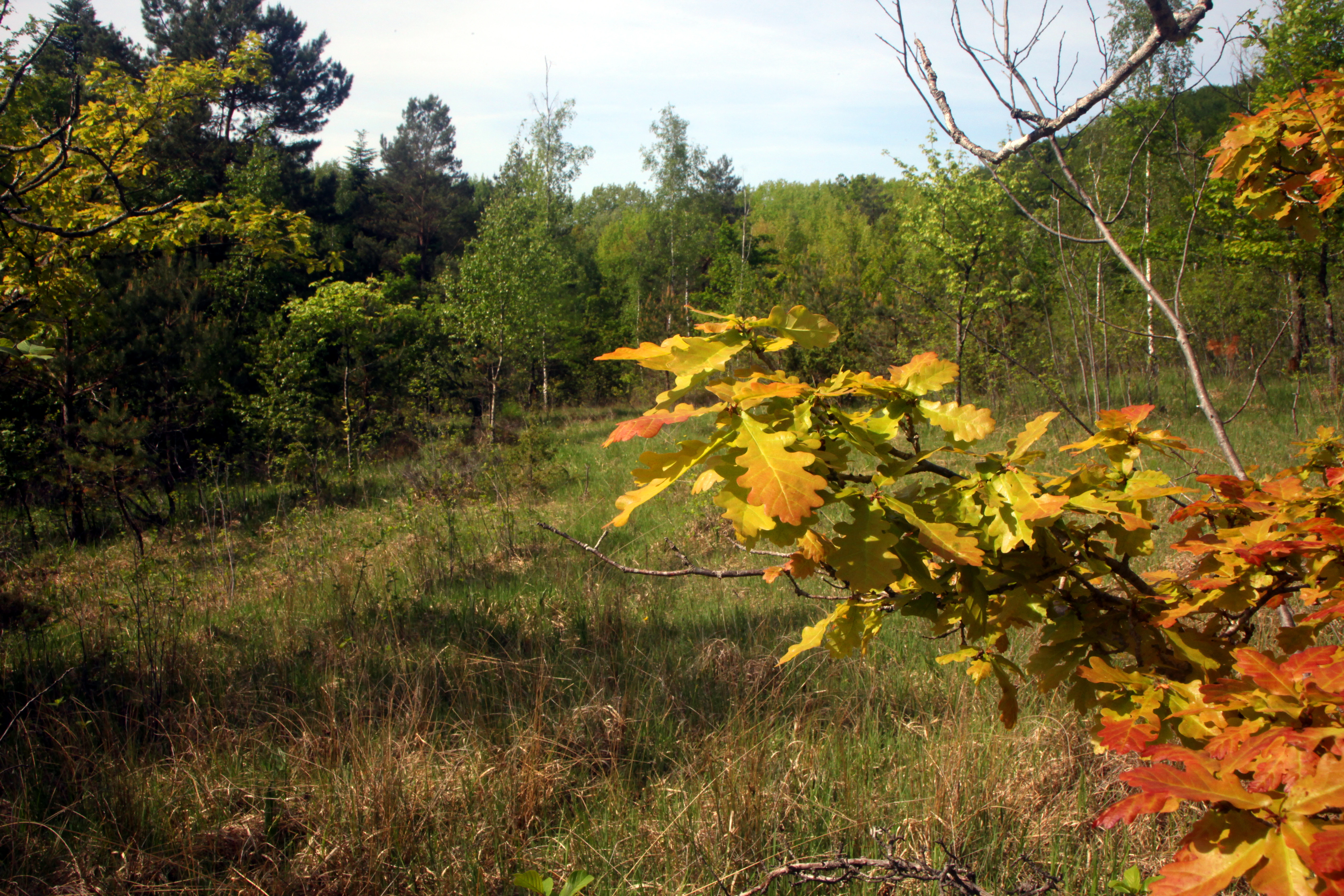
A close-up view of vibrant yellow and orange oak leaves on a branch in the foreground, with a grassy meadow and dense forest trees in the background.
Autumnal foliage of an oak tree within the Fontenelay valley wetland area.

Réserve naturelle régionale du vallon de Fontenelay wildlife and species highlights

The reserve supports a surprisingly diverse animal community for its size, shaped by the coexistence of open dry and open wet habitats. Birdlife is rich in semi-open-ground species, and around 57 species have been recorded, including the woodlark, red-backed shrike, coal tit, crested tit, and hazel grouse. These species depend on the mosaic of short grassland, scattered trees, and adjacent forest that the reserve maintains.

Reptiles, amphibians, and freshwater species are also well represented, with about twelve species recorded in this group. The fire salamander, the yellow-bellied toad, and the freshwater bullhead fish are among the species present. The small ruisseau des Merles supports a small population of the white-clawed crayfish, a regionally important species whose presence is one of the indicators of good freshwater habitat quality.

Invertebrate diversity is another strong point. The reserve hosts the yellow owl-fly, the scarce copper, the marsh fritillary, the stag beetle, the southern skimmer dragonfly, and the red-tipped grasshopper, among other species of conservation interest. Butterflies in particular benefit from the mix of dry grassland flowers and wet-meadow nectar sources that characterize the valley.
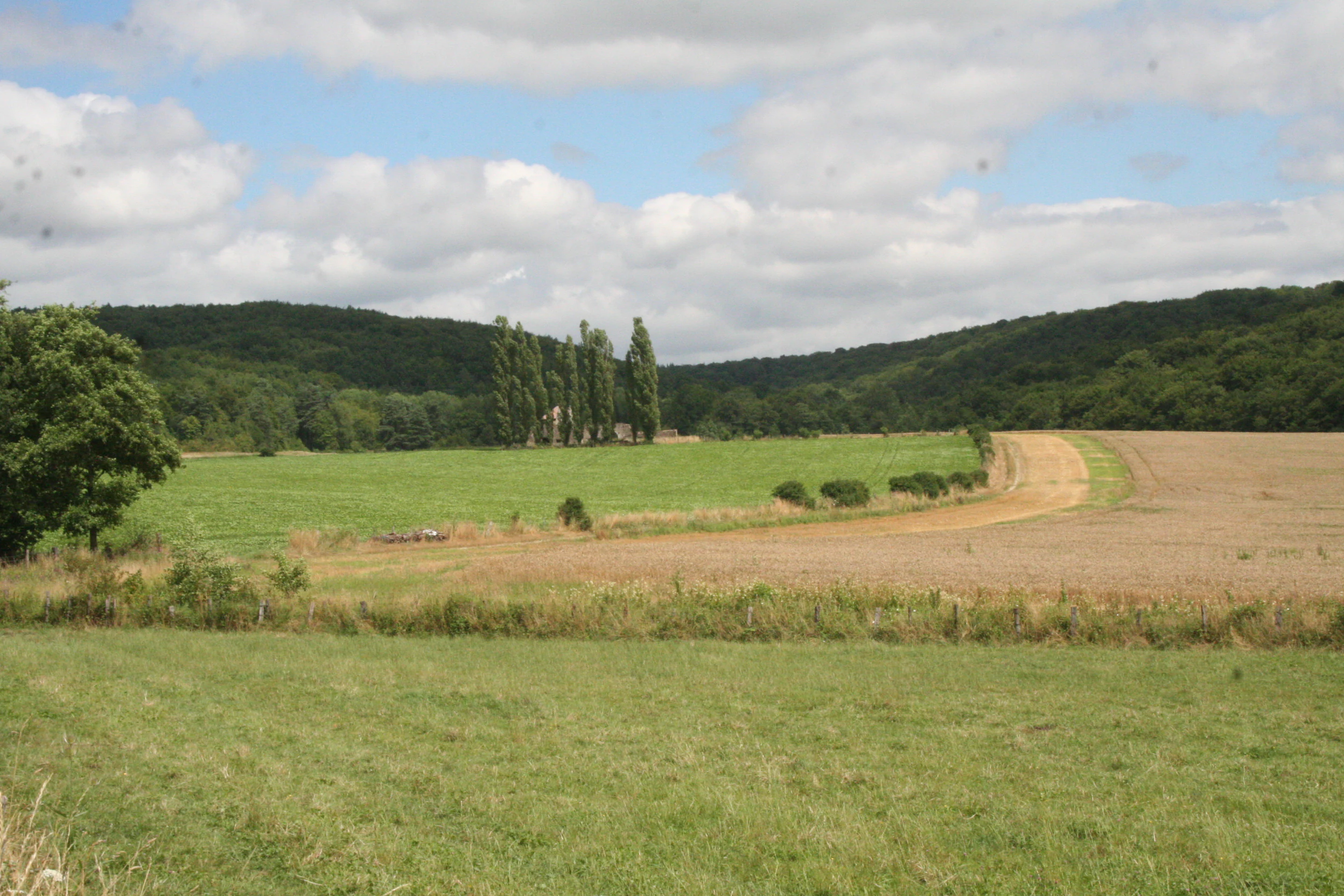
A wide outdoor view of open green fields with a dirt path winding through; in the background are low, tree-covered rolling hills under a partly cloudy sky.
A view of the landscape at the Vallon de Fontenelay nature reserve in France.

Réserve naturelle régionale du vallon de Fontenelay conservation status and protection priorities

The reserve is a small but strategically important site within the broader conservation network of Bourgogne-Franche-Comté. It preserves a combination of marly calcareous grassland and alkaline slope marsh that has been severely reduced across the wider region, and it acts as a refuge for species that have largely disappeared from surrounding farmland and forest.

Its designation as a Réserve naturelle régionale with IUCN Category IV status reflects its role in protecting specific habitats and species rather than an entire ecosystem. The site also falls within a ZNIEFF type I area covering the broader Vallon de Fontenelay and the ZNIEFF type II area covering the Monts de Gy, confirming its importance in national ecological inventories. Through management by the Conservatoire d'espaces naturels de Franche-Comté, the reserve contributes to regional efforts to maintain open habitats, support pollinator populations, and safeguard freshwater species such as the white-clawed crayfish.

Réserve naturelle régionale du vallon de Fontenelay cultural meaning and human context

The vallon de Fontenelay reflects a long tradition of low-intensity rural land use in the Haute-Saône, where poor marl soils were more easily maintained as pasture or rough meadow than plowed for crops. Extensive grazing, in particular, has kept the marly grasslands open and compatible with the orchid-rich flora that defines the site today. Volunteer work parties organized by local nature protection groups have been central to maintaining this character.

The reserve is now part of a wider set of nature-based visitor activities linked to the Monts de Gy, with the local tourist office organizing guided visits. This gives the site a quiet but real role in regional environmental education and in connecting local inhabitants and visitors to the distinctive natural heritage of the area.

Top sights and standout views in Réserve naturelle régionale du vallon de Fontenelay

Among the standout qualities of the reserve are its compact mosaic of marly grassland, alkaline marsh, and broadleaf woodland on a single east-facing slope, and its exceptional plant diversity for such a small site, including a community of around twenty orchid species.

It is also notable for supporting regionally rare wetland and grassland butterflies, amphibians, and the white-clawed crayfish in the Merles stream. The combination of a strong management presence by the Conservatoire d'espaces naturels de Franche-Comté and recognition in national ZNIEFF inventories further reinforces its regional importance.

Best time to visit Réserve naturelle régionale du vallon de Fontenelay

The reserve is best experienced in late spring and early summer, when the marly grasslands come into flower and the orchid-rich slopes are at their most visible. Early summer is also a good period to see marsh fritillaries, scarce coppers, and other characteristic butterflies, while bird species tied to semi-open habitats are most active in the morning hours.

Wetland conditions are most striking in spring, when seepage flows are strongest and the alkaline marsh is lush with cottongrass and gentians. Outside these seasons, the site remains ecologically interesting but the open grassland flora is much less visible, and the surrounding forest dominates the visual impression. As a matter of common sense, visitors should follow guidance from the Conservatoire d'espaces naturels de Franche-Comté or the local tourist office in the Monts de Gy regarding paths and seasonal conditions.

Monthly climate preview

Long-term monthly temperature averages and precipitation patterns for Réserve naturelle régionale du vallon de Fontenelay

Réserve Naturelle Régionale du Vallon de Fontenelay Climate and Temperature Normals

Representative coordinate measurements track the long-term annual temperature and precipitation rhythm across Réserve naturelle régionale du vallon de Fontenelay. Accessing the complete twelve-month climatology profile provides detailed monthly normals for deeper environmental analysis.
Annual mean10 °C
1 °C19 °C
Jan
Feb
Mar
Apr10°
May14°
Jun17°
Jul19°
Aug19°
Sep15°
Oct11°
Nov
Dec
Warmest month
July

19.3 °C

Coolest month
January

1.3 °C

Wettest month
November

3 mm/day

Driest month
March

2 mm/day

Park location guide

Geography guide, regional context, and park location map for Réserve naturelle régionale du vallon de Fontenelay

Réserve naturelle régionale du vallon de Fontenelay park geography, regions, and map view in France

Understand where Réserve naturelle régionale du vallon de Fontenelay sits in France through a broader geographic reading of the surrounding landscape, nearby location context, and its mapped position within the national park landscape.

How Réserve naturelle régionale du vallon de Fontenelay fits into France

France is a unitary semi-presidential republic and one of the world's largest economies. It borders Belgium, Luxembourg, Germany, Switzerland, Italy, Monaco, Andorra, and Spain, with a maritime border to the United Kingdom. The country is known for its cultural influence, art, cuisine, and political history spanning centuries.

Wider geography shaping Réserve naturelle régionale du vallon de Fontenelay in France

France is located in Western Europe. Metropolitan France extends from the Rhine to the Atlantic Ocean and from the Mediterranean Sea to the English Channel and North Sea. The country borders Belgium, Luxembourg, Germany, Switzerland, Italy, Monaco, Andorra, Spain, and has a maritime border with the United Kingdom.

Map view of Réserve naturelle régionale du vallon de Fontenelay

Use this park location map to pinpoint Réserve naturelle régionale du vallon de Fontenelay in France, understand its exact geographic position, and read its mapped placement within the surrounding landscape more clearly.

Pigeon | © OpenStreetMap contributors

Location context for Réserve naturelle régionale du vallon de Fontenelay

Bourgogne-Franche-Comté

Visual exploration of marly grasslands, seepage wetlands, and valley habitats

Réserve naturelle régionale du vallon de Fontenelay Photos and Protected Landscape Scenery

Visual documentation captures the unique topography of marly grasslands, slope seeps, and alkaline marshes across the protected valley. Examining terrain features and plant communities provides deeper context for understanding regional conservation habitats.

A close up view of an orange and brown checkered Marsh Fritillary butterfly resting on a bright yellow flower against a soft green blurred background.

A green grassy meadow filled with white fluffy heads of blooming cottongrass under a bright sky with a dense forest in the background.

A close up view of an Ascalaphus libelloides owlfly with yellow and black patterned wings, perched on a thin green blade of grass.

A close-up view of vibrant yellow and orange oak leaves on a branch in the foreground, with a grassy meadow and dense forest trees in the background.

A wide outdoor view of open green fields with a dirt path winding through; in the background are low, tree-covered rolling hills under a partly cloudy sky.

Park atlas

Compare nearby regional reserves and protected landscapes across the Monts de Gy hills

Parks Near Réserve Naturelle Régionale du Vallon de Fontenelay and Surrounding Protected Areas

Browsing other protected areas near Réserve naturelle régionale du vallon de Fontenelay reveals the broader ecological context of the Haute-Saône limestone terrain. Extending the search across surrounding regional nature reserves helps map connected habitats and similar valley ecosystems.
Nature reserveBourgogne-Franche-Comté
About 7.8 km away#1 closest

Southwest

Réserve naturelle régionale de la grotte de Beaumotte: Protected Karst and Cave Landscapes

A regional nature reserve focused on subterranean conservation.

Located in the Haute-Saône department, this regional nature reserve protects a critical limestone cave system that supports complex subterranean ecosystems and bat species of regional concern. The site occupies a modest surface area on the edge of the Monts de Gy massif, yet provides significant geological and ecological value through its horizontal gallery network and captured springs.

Area
0.088 km²
Established
2015
IUCN
IV
Relief
Upland
Nature reserveBourgogne-Franche-Comté
About 9.1 km away#2 closest

Northeast

Réserve naturelle régionale de la grotte de la Baume noire Protected Area Map and Geography

Regional karst landscape in Bourgogne-Franche-Comté

This 19-hectare reserve in the Monts de Gy is defined by its Jurassic limestone geology and protected cave systems. The site remains a primary focal point for monitoring subterranean bat habitats and maintaining the ecological integrity of the surrounding deciduous forest landscape.

Area
0.191 km²
Established
2015
IUCN
IV
Relief
Upland
Nature reserveBourgogne-Franche-Comté
About 28 km away#3 closest

South

Réserve naturelle régionale du gouffre du Creux à Pépé: Protected Karst and Bat Landscapes

Jura foothills nature reserve with critical cave habitats

Located in the Doubs department, the Réserve naturelle régionale du gouffre du Creux à Pépé protects a rare limestone sinkhole within a mosaic of dry calcareous grassland. This site stands as a key node in regional bat conservation efforts, providing essential wintering and spring transit roosts within the Jura mountain foothills, all anchored by a dense network of biotope and Natura 2000 protective instruments.

Area
0.007 km²
Established
2015
IUCN
IV
Relief
Upland
Watercolor painting of a hilly landscape featuring green rolling hills, a rocky cliff formation to the right, and trees against a soft white background.
Nature reserveBourgogne-Franche-Comté
About 29 km away#4 closest

South

Réserve naturelle régionale des grottes de Chenecey: Protected Karst and Limestone Cliffs

Regional Nature Reserve in the Doubs, France

This nature reserve protects a diverse mosaic of habitats along the Loue valley. The site integrates surface calcareous grasslands with fragile underground cave galleries, providing critical refuge for rare bat species. It represents a significant conservation effort in the Jura region, mapping the intersection of subterranean voids and exposed limestone terrain.

Area
0.214 km²
Established
2017
IUCN
IV
Relief
Upland
Nature reserveBourgogne-Franche-Comté
About 29 km away#5 closest

Northeast

Réserve naturelle régionale de la grotte de la Baume: Regional Nature Reserve Atlas

Mapping karst cave systems and bat habitats in Haute-Saône

The Réserve naturelle régionale de la grotte de la Baume protects a limestone cave system on the edge of the plateau near Échenoz-la-Méline. Its small but intensive protected perimeter serves as a vital hibernation site and autumn transit corridor, forming part of a broader ecological network across the Franche-Comté landscape.

Area
0.175 km²
Established
2015
IUCN
IV
Relief
Upland
A horizontal watercolor painting showing a soft, impressionistic landscape with layers of green hills and trees against a pale, light background.
Nature reserveBourgogne-Franche-Comté
About 33 km away#6 closest

Northeast

Réserve naturelle nationale du Sabot de Frotey: Geographic and Protected Area Overview

Limestone plateau and calcareous grasslands in Haute-Saône

Located near Vesoul, the Réserve naturelle nationale du Sabot de Frotey features a prominent southwest-facing cliff and a rich expanse of dry grassland. This nature reserve provides critical habitat for orchids and diverse butterfly assemblages within a landscape defined by erosion-shaped monoliths and Mediterranean-edge flora.

Area
0.98 km²
Established
1981
IUCN
IV
Relief
Upland
A horizontal watercolor painting depicting a soft-edged, green-and-white landscape of rolling hills and distant limestone ridgelines.
Nature reserveBourgogne-Franche-Comté
About 37 km away#7 closest

Southeast

Réserve naturelle nationale du ravin de Valbois: Protected Jura Blind Valley and Limestone Ravines

Geographic landscape exploration of the Doubs department's protected natural reserve.

Spanning 235 hectares, this protected nature reserve in Bourgogne-Franche-Comté preserves a textbook Jura reculée. The terrain showcases vertical limestone cliffs, deep forested ravines, and a 40-meter cascade. As a hotspot for butterfly diversity and Mediterranean-montane vegetation, the area offers a significant study in microclimatic gradients and old-growth forest conservation within the French landscape.

Area
2.35 km²
Established
1983
IUCN
IV
Relief
Mountain
Nature reserveHaute-Saône
About 38 km away#8 closest

North

Réserve naturelle nationale de la grotte du Carroussel: Limestone Cave and Bat Reserve

Protected underground landscapes in the Haute-Saône region

Investigate the unique geographic setting of the Réserve naturelle nationale de la grotte du Carroussel. Located on a forested limestone plateau in the Val de Saône, this nature reserve serves as an essential maternity and hibernation site. Learn about its cave morphology, protected forest boundaries, and role within the regional ecological network.

Area
0.023 km²
Established
1990
IUCN
IV
Relief
Upland

Common questions about visiting, size, designation, and location context for Réserve naturelle régionale du vallon de Fontenelay

Réserve naturelle régionale du vallon de Fontenelay FAQs for park facts, access, geography, and protected area context

Find quick answers about Réserve naturelle régionale du vallon de Fontenelay, including protected-area facts, park geography, trail and visitor context, and how the park fits into its surrounding country and regional landscape.
MoriAtlas Explorer

Continue Your Protected Areas Search Across the Global Atlas

Deepen your exploration by continuing the structured search for national parks and protected areas worldwide. Utilize the comprehensive filtering capabilities to compare different conservation landscapes and refine your understanding of global park geography. Discover more about the distribution and characteristics of protected natural areas.

Global natural geography