Mori Atlas logo
Wildlife reserveRideau Migratory Bird Sanctuary

Mapped riverine boundaries and strategic waterfowl staging habitat within the Rideau Valley watershed

Rideau Migratory Bird Sanctuary: Protected Riparian Corridor and Wildlife Reserve in Eastern Ontario

The Rideau Migratory Bird Sanctuary serves as a federally protected wildlife reserve safeguarding a critical 5.6 kilometer stretch of the Rideau River near Merrickville. This riparian habitat functions as an essential autumn staging area for diverse waterfowl species including Canada geese, mallards, and teal. By maintaining protected boundaries along this historic river corridor, the sanctuary secures a vital link in the regional geography connecting eastern Ontario landscapes to the broader watershed.

migratory bird sanctuarywaterfowl refugeCanada geesewaterfowl stagingriparian habitatRideau River

Rideau Migratory Bird Sanctuary

Wildlife reserve

Park overview

Structured park overview, official facts, and landscape profile for Rideau Migratory Bird Sanctuary

Rideau Migratory Bird Sanctuary park facts, protected area profile, and essential visitor context

Review the core facts for Rideau Migratory Bird Sanctuary, including designation, size, terrain, visitor scale, habitats, and operating context in one park-focused overview.

About Rideau Migratory Bird Sanctuary

The Rideau Migratory Bird Sanctuary is a federally designated bird protection area on a section of the Rideau River in eastern Ontario. Established in 1957, it lies on the western edge of Merrickville, roughly 55 km south-southwest of Ottawa. The sanctuary covers about 7.52 square kilometres, centred on a 5.6 km reach of the river together with adjacent lands on both banks.

Its purpose is straightforward: to maintain a refuge for migratory waterfowl using the Rideau corridor. The site is administered by the Canadian Wildlife Service and has no assigned IUCN protected-area category, reflecting its narrow, species-and-habitat mandate rather than a broader landscape designation.

What makes the sanctuary culturally distinctive is its layered context. The river stretch is part of the Rideau Canal, a National Historic Site of Canada and a UNESCO World Heritage Site, and the river itself is recognized as a Canadian Heritage River. As a result, a relatively small waterfowl refuge sits within one of eastern Ontario's most historically significant inland waterway systems, linking ecological protection with a corridor that has carried people and goods since the early nineteenth century.

Quick facts and research context for Rideau Migratory Bird Sanctuary

The Rideau Migratory Bird Sanctuary was established in 1957 in Ontario, Canada, and is administered by the Canadian Wildlife Service. It covers roughly 7.52 square kilometres, of which a 5.6 km stretch of the Rideau River near Merrickville forms the core. The river section is also part of the Rideau Canal, a National Historic Site and UNESCO World Heritage Site.

Protection and recognition

Examine documented protected area designation records and official database metrics.

Rideau Migratory Bird Sanctuary Protection Status and Administrative Records

Review documented protection status parameters and administrative designations established for Rideau Migratory Bird Sanctuary within global protected area datasets. Access structured governance records and official recognition metrics maintained across international conservation registries.

Protection details

WDPA ID
555758212
Park context

Deeper park guide and search-rich context for Rideau Migratory Bird Sanctuary

Rideau Migratory Bird Sanctuary history, landscape, wildlife, and travel context

Explore Rideau Migratory Bird Sanctuary through its history, landscape character, ecosystems, wildlife, conservation priorities, cultural context, and seasonal travel timing in a structured park guide built for atlas discovery and search intent.

Why Rideau Migratory Bird Sanctuary stands out

The sanctuary is best known as a staging area where Canada geese and several duck species, including mallard, blue-winged teal, and ring-necked duck, congregate during autumn migration. The protected river stretch lies within the Rideau Canal UNESCO World Heritage corridor.

Rideau Migratory Bird Sanctuary history and protected-area timeline

The sanctuary was established in 1957 as a federal Migratory Bird Sanctuary under the Canadian Wildlife Service. It has been administered continuously by that agency as part of the national network of bird sanctuaries protecting key waterfowl habitat. No deeper institutional or founding history is supported by the available source material.

Rideau Migratory Bird Sanctuary landscape and geographic character

The sanctuary's landscape is defined by a 5.6 km section of the Rideau River near Merrickville, flanked by adjoining terrestrial habitat on both banks. The river corridor sits within the broader Rideau Valley of eastern Ontario, a low-relief landscape of mixed forest, agricultural land, and wetland margins typical of the Ottawa River watershed. The protected zone follows the river rather than enclosing a large upland block, so terrain character is largely shaped by shorelines, floodplain vegetation, and riparian habitat rather than dramatic landforms. There is not enough source detail to describe specific landforms or surficial geology in more depth.

Rideau Migratory Bird Sanctuary ecosystems, habitats, and plant life

Ecologically, the sanctuary is a riparian and aquatic setting rather than a broad terrestrial ecosystem. The protected strip of river and adjacent banks functions as a continuous habitat corridor linking upstream and downstream stretches of the Rideau. The mix of open water, shoreline vegetation, mudflats, and fringing woodland typical of the Rideau at this latitude provides feeding, resting, and roosting conditions for waterfowl during migration. Its ecological value lies in concentration: although small in area, the sanctuary secures habitat at a pinch point used seasonally by large numbers of birds, which is precisely why federal protection was warranted.

Rideau Migratory Bird Sanctuary wildlife and species highlights

The sanctuary's wildlife importance is focused on migratory waterfowl. During the autumn migration season it functions as a major staging area, with flocks gathering to rest and feed before continuing south. Up to roughly 1,000 Canada geese have been recorded using the site at peak, alongside comparable aggregations of ducks. Documented duck species include mallard, blue-winged teal, and ring-necked duck, along with a 'Dunkelente' (literally 'dark duck,' typically referring to American black duck or a similar dark-plumaged dabbling species in regional terminology). The site is not described as a diverse breeding sanctuary but rather as a stopover refuge within a longer migratory network, which gives it disproportionate seasonal importance compared to its modest year-round footprint.

Rideau Migratory Bird Sanctuary conservation status and protection priorities

The sanctuary's conservation significance rests on its role within the federal Migratory Bird Sanctuary program, one of the principal tools used by the Canadian Wildlife Service to protect habitat for migratory birds. By safeguarding a key reach of the Rideau River, the site helps maintain functional stopover habitat for geese and ducks moving through eastern Ontario. The fact that the protected river stretch coincides with the Rideau Canal, a UNESCO World Heritage Site and National Historic Site, also gives the sanctuary a footprint within a broader landscape of recognized heritage and ecological corridors, even if the IUCN has not assigned it a formal protected-area category.

Rideau Migratory Bird Sanctuary cultural meaning and human context

The cultural context of the sanctuary is inseparable from its river. The protected stretch of the Rideau River lies within the Rideau Canal, a National Historic Site of Canada and a UNESCO World Heritage Site, linking the sanctuary to one of Canada's most iconic nineteenth-century engineering and navigation corridors. The Rideau River is itself designated as a Canadian Heritage River, reinforcing the region's layered identity as both a working waterway and a protected cultural landscape. The sanctuary therefore reflects a North American conservation tradition in which wildlife protection and historical waterway stewardship often overlap.

Top sights and standout views in Rideau Migratory Bird Sanctuary

Highlights of the Rideau Migratory Bird Sanctuary include its position along the Rideau River within the Rideau Canal UNESCO World Heritage corridor, its role as a major autumn staging site for Canada geese and several duck species, and its long-standing federal protection dating to 1957. Compact in size but strategically located, the sanctuary illustrates how small, targeted reserves can play an outsized role in safeguarding migratory waterfowl.

Best time to visit Rideau Migratory Bird Sanctuary

The sanctuary's character is most pronounced during autumn, when migratory waterfowl concentrate along the river for staging and feeding before continuing their migration. Visitors interested in seeing the site's defining species, Canada geese and ducks, are likely to find autumn the most rewarding period. Spring and summer are less specifically described in the available source, and broad seasonal visitor logistics are not detailed enough to support further specific advice.

Monthly climate preview

Track monthly temperature ranges and precipitation averages across the sanctuary coordinate.

Rideau Migratory Bird Sanctuary Climate Normals and Annual Temperature Patterns

Representative coordinate records outline long term monthly temperature swings alongside steady precipitation patterns for Rideau Migratory Bird Sanctuary. Detailed twelve month breakdowns offer broader context for analyzing year round thermal shifts at the protected location.
Annual mean6 °C
-10 °C21 °C
Jan-10°
Feb-9°
Mar-2°
Apr
May13°
Jun18°
Jul21°
Aug20°
Sep16°
Oct
Nov
Dec-5°
Warmest month
July

20.7 °C

Coolest month
January

-9.9 °C

Wettest month
June

3.3 mm/day

Driest month
February

1.7 mm/day

Park location guide

Geography guide, regional context, and park location map for Rideau Migratory Bird Sanctuary

Rideau Migratory Bird Sanctuary park geography, regions, and map view in Canada

Understand where Rideau Migratory Bird Sanctuary sits in Canada through a broader geographic reading of the surrounding landscape, nearby location context, and its mapped position within the national park landscape.

How Rideau Migratory Bird Sanctuary fits into Canada

Canada is a federal parliamentary constitutional monarchy spanning North America from the Atlantic to the Pacific and Arctic Oceans. With a population of over 41 million, it is officially bilingual in English and French at the federal level. The country gained independence from the United Kingdom through a gradual process culminating in 1982.

Wider geography shaping Rideau Migratory Bird Sanctuary in Canada

Canada occupies the northern portion of North America, sharing its longest international border with the United States. The country extends from the Atlantic Ocean to the Pacific Ocean and northward into the Arctic Ocean, giving it the longest coastline of any nation.

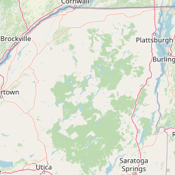
Map view of Rideau Migratory Bird Sanctuary

Use this park location map to pinpoint Rideau Migratory Bird Sanctuary in Canada, understand its exact geographic position, and read its mapped placement within the surrounding landscape more clearly.

Pigeon | © OpenStreetMap contributors

Location context for Rideau Migratory Bird Sanctuary

Ontario
Park atlas

Compare nearby protected areas and connected wildlife corridors across eastern Ontario

Parks Near Rideau Migratory Bird Sanctuary And Regional Protected Landscapes

Visitors exploring Rideau Migratory Bird Sanctuary can compare adjacent regional reserves and wetland habitats across the surrounding watershed. Evaluating these connected protected landscapes reveals broader geographic patterns in eastern Ontario conservation.
Wildlife reserveOntario
About 32 km away#1 closest

Northwest

Zugvogelschutzgebiet Mississippi Lake Protected Landscape and Wildlife Reserve Atlas

Waterfowl habitat and wetland geography in Ontario

Zugvogelschutzgebiet Mississippi Lake serves as a designated wildlife reserve providing essential staging grounds for migratory waterfowl. Located at the river-mouth interface on Mississippi Lake, the area encompasses provincially significant wetlands within Ewan Bay. This protected footprint offers a distinct look at the quiet, low-relief hydrology and marsh ecology characteristic of the broader southern Ontario basin.

Area
2.84 km²
Established
1959
IUCN
IV
Relief
Lowland
Watercolor painting of green hills, islands, and a body of water under a pale yellow sky
National parkOntario
About 40 km away#2 closest

South

Thousand Islands National Park: Exploring Ontario's Protected Landscape Geography

Discover the mapped terrain and regional context of this national park.

Uncover the protected landscape identity of Thousand Islands National Park, a key national park located in Ontario. This resource focuses on its geographic setting, mapped boundaries, and overall atlas context, providing a clear understanding of its role as a protected area. Explore how its unique terrain contributes to the regional geography and the broader national park network, offering valuable insight for landscape-focused discovery.

Area
24.4 km²
Established
1904
IUCN
II
Visitors
109.3K annual
A soft watercolor painting depicting a wide, marshy wetland scene with gentle green hills in the distance and reflections on the water surface.
Wildlife reserveQuebec
About 109 km away#3 closest

East

Réserve nationale de faune du lac-Saint-François: A Protected Wetland Landscape in Quebec

Explore wildlife reserve boundaries, riparian habitats, and St. Lawrence River geography.

This protected area safeguards a diverse freshwater wetland complex along the St. Lawrence River. Covering marshes, cedar stands, and mixed hardwood forests, the reserve provides a critical sanctuary for migratory species. The geography of the site offers a unique look at transition zones between open water and inland plains, serving as a key node for bird conservation in Quebec.

Area
15.21 km²
Established
1978
IUCN
III
Relief
Lowland
Wildlife reserveOntario
About 134 km away#4 closest

Southwest

Prince Edward Point National Wildlife Area: Protected Geography and Migration Hub

Coastal woodland and shoreline terrain in southeastern Ontario

Prince Edward Point National Wildlife Area is a federal reserve located on a narrow peninsula extending into Lake Ontario. This area features a diverse landscape of forest patches, open meadows, and jagged lakefront, providing critical refuge for migrating bird species. As a long-standing center for ornithological research, the site remains an essential node for understanding the regional migration patterns and natural heritage of the Great Lakes basin.

Area
5.6 km²
Established
1980
IUCN
Ia
Relief
Lowland
A soft, painterly watercolor illustration showing a shallow waterway, green grassy islands, and soft rolling hills in the distance.
Nature reserveQuebec
About 164 km away#5 closest

East

Îles de la Paix Migratory Bird Sanctuary: Protected Island Geography and Wetland Maps

A vital riverine habitat within the St. Lawrence River basin

Examine the unique river-island topography of the Îles de la Paix Migratory Bird Sanctuary in Quebec. This protected area offers a rare glimpse into a dynamic landscape of marshes and flooded forests, serving as a critical node in the St. Lawrence River migratory flyway near the Montreal metropolitan region.

Area
10.92 km²
Established
1972
IUCN
III
Relief
Lowland
A soft, watercolor painting of a calm river winding through a green landscape with trees and rolling hills in the background.
Wildlife reserveQuebec
About 166 km away#6 closest

East

Réserve nationale de faune des îles de la Paix: Geography of an Island Wetland Refuge

A protected wildlife corridor in southwestern Quebec

The Réserve nationale de faune des îles de la Paix comprises a cluster of islands and protected wetlands in the St. Lawrence River. This site provides critical nesting and staging grounds within a managed habitat system, connecting forested terrestrial areas with expansive aquatic zones essential for migratory bird species.

Area
1.87 km²
Established
1977
IUCN
Ia
Relief
Lowland
Marine protected areaNew York
About 169 km away#7 closest

Southwest

Lake Ontario National Marine Sanctuary: Geographic Atlas and Protected Area Overview

Mapping freshwater maritime heritage and coastal New York landscapes.

Spanning the southeastern waters of Lake Ontario, this marine protected area safeguards dozens of historic shipwrecks and vital Indigenous cultural sites. This atlas entry provides geographic context on the sanctuary boundaries, submerged archaeological zones, and the surrounding New York freshwater environment.

Area
4,460 km²
Established
2024
IUCN
V
Relief
Lowland
Wildlife reserveOntario
About 170 km away#8 closest

Southwest

Wellers Bay National Wildlife Area: Coastal and Island Geography in Ontario

An important Great Lakes barrier beach protected reserve

Wellers Bay National Wildlife Area contains a rare collection of undeveloped shorelines, including the Baldhead peninsula and offshore islands. This protected area offers a deep look into the littoral processes of Lake Ontario, providing crucial sanctuary for waterbirds and endangered species within a fragile, compact, and natural woodland environment.

Area
0.74 km²
Established
1978
IUCN
Ia
Scope
Terrestrial

Common questions about visiting, size, designation, and location context for Rideau Migratory Bird Sanctuary

Rideau Migratory Bird Sanctuary FAQs for park facts, access, geography, and protected area context

Find quick answers about Rideau Migratory Bird Sanctuary, including protected-area facts, park geography, trail and visitor context, and how the park fits into its surrounding country and regional landscape.
MoriAtlas Explorer

Continue Your Protected Areas Search Across the Global Atlas

Deepen your exploration by continuing the structured search for national parks and protected areas worldwide. Utilize the comprehensive filtering capabilities to compare different conservation landscapes and refine your understanding of global park geography. Discover more about the distribution and characteristics of protected natural areas.

Global natural geography