
Mori Atlas logo
Nature reserveRiedwiesen

A study of urban-adjacent meadow geography and fragmented floodplain ecology within the Frankfurt region.

Riedwiesen Nature Reserve: Investigating the Protected Wetland Landscapes of the Nidda Floodplain in Hessen

(Naturschutzgebiet Riedwiesen)

Riedwiesen stands as a distinct nature reserve situated on the eastern edge of the Niederursel district, serving as a vital remnant of the historic wet meadow habitat within the northern Nidda floodplain of Hessen. This 20-hectare site illustrates the conservation of traditional floodplain terrain and amphibian populations despite being embedded within a dense metropolitan environment. The reserve functions as an ecological island, preserving the character of the Grüngürtel while maintaining specific hydrological conditions critical for wet meadow flora.

wet meadowNidda floodplainnature reserveurban natureFrankfurt Grüngürtelamphibian habitat
A flat-style digital illustration showing a mountain range with a waterfall, framed by trees on the left and right in the foreground and a grassy meadow at the base.

Riedwiesen

Nature reserve

Park overview

Structured park overview, official facts, and landscape profile for Riedwiesen

Riedwiesen park facts, protected area profile, and essential visitor context

Review the core facts for Riedwiesen, including designation, size, terrain, visitor scale, habitats, and operating context in one park-focused overview.

About Riedwiesen

Riedwiesen is a formally designated nature reserve in the northern part of Frankfurt am Main, set within the open mead the Nidda river. Although small in scale, the reserve plays a meaningful role within Frankfurt's network of protected meadows and wetlands, contributing to the ecological function of the Grüngürtel that rings the inner city.

The reserve lies along the western bank of the Nidda, where historic floodplain soils and a relatively high groundwater table have allowed wet meadow vegetation to persist. The landscape includes taller herbaceous plants, sedges, and scattered trees such as silver birch that together produce the open meadow and light wet woodland mosaic typical of the area. Beyond the reserve itself, the broader Grüngürtel connects to other protected meadow sites along the Nidda, such as the Seckbacher Ried, Enkheimer Ried, and Harheimer Ried, together forming a connected corridor of semi-natural habitat.

Ecologically, the reserve is significant for maintaining wet meadow flora and for providing breeding and foraging habitat for amphibians that depend on seasonal standing water and moist soils. Even small protected areas like Riedwiesen contribute to maintaining regional biodiversity in a region dominated by urban land use, transport corridors, and agriculture.

From a planning and conservation perspective, the reserve reflects Germany's system of formally designated Naturschutzgebiete, which are the strongest form of area-based nature protection under federal and state law. The Riedwiesen is anchored in this system through its 1983 designation, its official WDPA entry, and its alignment with international IUCN classifications. Its continued protection within a heavily urbanized context makes it a useful example of where strict nature conservation, public green space, and infrastructural pressures intersect in Frankfurt am Main.

Quick facts and research context for Riedwiesen

Riedwiesen is a nature reserve (Naturschutzgebiet) located in Frankfurt am Main, Hesse, Germany, within the northern floodplain of the Nidda river. It lies on the eastern edge of the Niederursel and Mertonviertel districts and forms part of Frankfurt's broader Grüngürtel green belt. The reserve covers roughly 20.5 hectares, has the official nature reserve code 1412004, and is internationally categorized as an IUCN Category IV area. It has been protected since 1983, and its meadow habitats host characteristic wet meadow plants as well as amphibians and small mammals typical of the Nidda valley.

Protection and recognition

Examine documented protected area records and international recognition data

Riedwiesen Protection Status and Official Conservation Records

Riedwiesen maintains structured conservation data derived from official protected area databases and registry records. Review verified administrative designations and baseline protection parameters without external assumptions.

Protection details

WDPA ID
82416
Park context

Deeper park guide and search-rich context for Riedwiesen

Riedwiesen history, landscape, wildlife, and travel context

Explore Riedwiesen through its history, landscape character, ecosystems, wildlife, conservation priorities, cultural context, and seasonal travel timing in a structured park guide built for atlas discovery and search intent.

Why Riedwiesen stands out

Riedwiesen is best known as a compact example of a protected wet meadow, or 'Ried', within an urban setting, conserving a small but ecologically distinct fragment of the northern Nidda floodplain. The reserve is recognized for its characteristic meadow vegetation and for sustaining amphibians such as the northern crested newt alongside common frog and toad species. Its proximity to dense residential neighborhoods and a major motorway also makes it a notable illustration of how small nature reserves function as ecological islands inside the metropolitan landscape of Frankfurt.
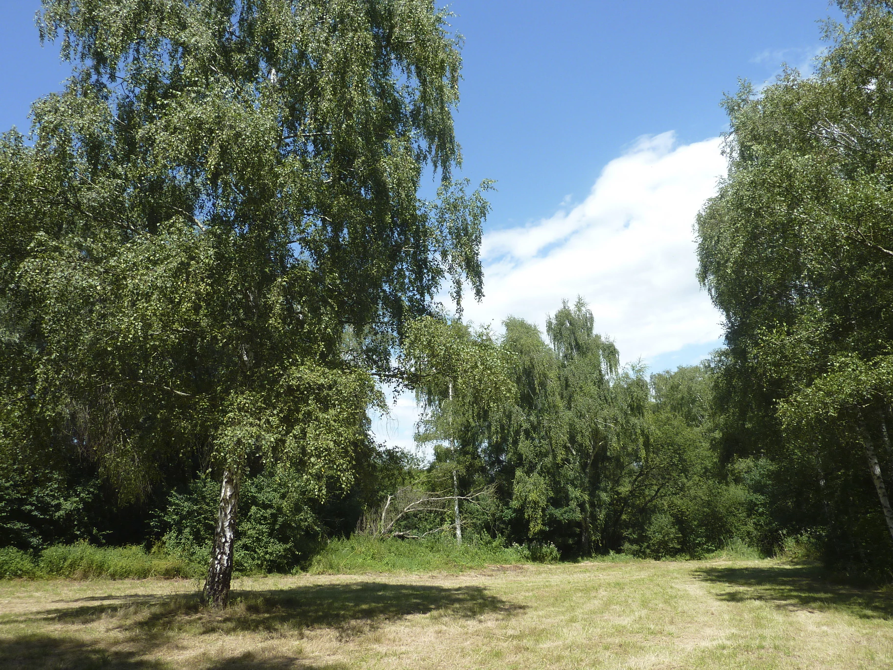
A wide, eye-level outdoor shot showing a sunlit grassy clearing at the edge of a woodland area with several tall, leafy birch trees under a clear blue sky.
A scenic view within the Riedwiesen nature reserve, featuring deciduous trees and open grassland.

Riedwiesen history and protected-area timeline

Riedwiesen has been formally protected as a nature reserve since 1983, when the Hessian authorities designated the area along the northern Nidda floodplain as a Naturschutzgebiet. The reserve carries the official code 1412004 and is entered in the World Database on Protected Areas under WDPA ID 82416, aligning it with international recording systems for protected areas. The 1983 designation reflected growing recognition, beginning in the late twentieth century, that even small wet meadow fragments inside the expanding Frankfurt urban region warranted long-term legal protection to maintain their characteristic flora and fauna. The reserve has since remained part of the city's network of protected meadow sites embedded within the Frankfurt Grüngürtel, contributing to the broader post-war effort to keep meaningful green corridors within a rapidly growing metropolitan area.

Riedwiesen landscape and geographic character

The landscape of Riedwiesen is shaped by its position in the floodplain of the Nidda river. The terrain is flat to gently undulating, typical of an alluvial valley floor, with soils that retain moisture for much of the year. The open character of the area is dominated by meadows, with scattered trees, including silver birch, breaking up the herbaceous cover.

Along the edges of the reserve, the environment transitions sharply: on one side lies the Nidda river with its riparian fringe, while on the other side are the built-up districts of Niederursel and the Mertonviertel, and on the northeastern edge, the A661 motorway. This compact setting gives the reserve a clearly defined boundary between urban infrastructure and protected meadow habitat. The Nidda itself, with its wet banks and shallow floodplain depressions, enhances the meadow's hydrological character and shapes the vegetation pattern across the site.

Within Frankfurt's larger Grüngürtel, the Riedwiesen represents a classic example of the 'Ried', a Southern German term for a wet meadow or reed-influenced grassland, that historically occurred along the lower Nidda. The present-day landscape, although reduced in extent, preserves much of the visual and ecological character of these traditional floodplain meadows.

Riedwiesen ecosystems, habitats, and plant life

Ecologically, Riedwiesen belongs to the wet meadow habitat type that develops on periodically moist, nutrient-rich floodplain soils. The reserve's vegetation reflects this setting through a mixture of tall forbs, sedges, and silver birch, producing a mosaic of open meadow and light woody cover. Characteristic plant species recorded at the site include meadowsweet, common fleabane, and tufted sedge, alongside birch, all of which are typical components of lowland wet meadows in central Germany.

The reserve's hydrology is closely tied to the Nidda floodplain, and seasonal fluctuations in groundwater and surface moisture shape the structure of the habitat. These conditions support a community of organisms that rely on consistently damp or temporarily flooded conditions. Because the area is small and bordered by urban structures, it functions as a localized ecological refuge rather than a large continuous habitat, and its ecological value depends on careful management to prevent shrub encroachment or drying out of the meadow sward.

Within Frankfurt's wider ecological network, the Riedwiesen complements nearby Ried-type reserves such as the Seckbacher Ried and Enkheimer Ried, helping maintain a chain of similar habitats along the Nidda. Together, these reserves contribute to regional biodiversity by supporting wet meadow communities that would otherwise be poorly represented in the intensively used landscape around Frankfurt.

Riedwiesen wildlife and species highlights

The wildlife of Riedwiesen is shaped by the wet meadow character of the floodplain and includes both resident meadow species and animals tied to damp microhabitats. Amphibians are among the most characteristic groups, with the northern crested newt and common toad present in suitable wet zones, along with water frogs in the more aquatic parts of the reserve.

Small mammals typical of grassland and scrub edge habitats are also recorded, including the common vole and the bank vole. These species benefit from the mix of tall herbaceous vegetation, sedges, and scattered woody cover that provides both food and refuge. The presence of these mammals in turn contributes to the food supply for predators that range through the broader Grüngürtel, such as birds of prey and foxes.

Although the reserve is small, its combination of meadow, wet depressions, and proximity to the Nidda allows it to support a relatively diverse amphibian and small mammal community. The site's location, embedded within an urban matrix, makes its value for local wildlife particularly important, as similar habitats in the surrounding area are largely absent or heavily disturbed.

Riedwiesen conservation status and protection priorities

Conservation at Riedwiesen is anchored in its formal designation as a Hessian Naturschutzgebiet, the strongest category of area-based nature protection available under German federal and state nature law. This designation, in place since 1983, requires active management to preserve the wet meadow character and associated species, rather than simply setting land aside. The reserve's IUCN Category IV classification further reinforces its international recognition as a habitat and species management area.

The conservation value of the site rests on several factors: the small but ecologically distinct wet meadow habitat it preserves, its contribution to amphibian and small mammal conservation in a heavily urbanized region, and its place within the larger Grüngürtel network of protected green spaces surrounding Frankfurt's core. Even though the area is only around 20 hectares, it supports meadow communities and species that are regionally uncommon.

From a wider perspective, Riedwiesen illustrates the importance of small reserves in metropolitan conservation strategies. Such sites act as refuges, stepping stones, and benchmarks for habitat quality within otherwise heavily altered landscapes, and they help maintain ecological functions, including floodplain water retention and local biodiversity, that are beneficial beyond the reserve boundaries. Continued management of the meadow, control of invasive or woody encroachment, and protection from the disturbance effects of the adjacent motorway and urban development are central to maintaining these values over time.

Riedwiesen cultural meaning and human context

The name 'Riedwiesen' reflects the long-standing regional terminology for wet meadows or marshy grasslands in southern Germany, where 'Ried' refers to reed- or sedge-influenced wet habitat. The reserve is part of a landscape tradition of lowland meadow use along the Nidda, where such wet grasslands once played a practical role in hay production and grazing, even as their ecological function grew in importance over time. Today, these meadows are valued primarily for their nature conservation significance rather than for agricultural use, reflecting a broader shift in how floodplain landscapes are perceived in urban Germany.

Top sights and standout views in Riedwiesen

The standout features of Riedwiesen include its well-preserved wet meadow vegetation along the northern Nidda floodplain, its ecologically valuable amphibian population, and its role as part of Frankfurt's Grüngürtel. The reserve's compact size, embedded between the Nidda, residential districts, and the A661 motorway, makes it a distinctive example of urban-adjacent nature conservation. Its long-standing protection since 1983 and its position within a chain of similar Ried-type reserves further enhance its importance as a small but resilient ecological refuge in the Frankfurt metropolitan area.

Best time to visit Riedwiesen

The wet meadow character of Riedwiesen varies with the seasons, and late spring through early summer is generally when the herbaceous layer is most developed and the meadow vegetation is at its most expressive. Warmer months also increase the likelihood of observing amphibian activity in damp zones, while autumn brings changes in grass and sedge structure. Because the reserve is small and bordered by infrastructure, visits are best undertaken during daylight hours with awareness of the limited footprint of the protected area and its proximity to busy roads.

Monthly climate preview

Long-term representative monthly averages for weather patterns in Hessen

Riedwiesen Climate Normals, Annual Temperature and Precipitation Rhythm

Representative coordinate records show measured temperature ranges alongside steady precipitation values across the twelve-month cycle. Examining the complete monthly climate normals reveals deeper temporal shifts in average conditions for this protected location.
Annual mean10 °C
0 °C21 °C
Jan
Feb
Mar
Apr10°
May14°
Jun18°
Jul21°
Aug20°
Sep15°
Oct10°
Nov
Dec
Warmest month
July

20.6 °C

Coolest month
January

0.2 °C

Wettest month
July

2.2 mm/day

Driest month
April

1.4 mm/day

Park location guide

Geography guide, regional context, and park location map for Riedwiesen

Riedwiesen park geography, regions, and map view in Germany

Understand where Riedwiesen sits in Germany through a broader geographic reading of the surrounding landscape, nearby location context, and its mapped position within the national park landscape.

How Riedwiesen fits into Germany

Germany is a federal republic in Western and Central Europe with a population of over 83 million across sixteen constituent states. It is Europe's largest economy by nominal GDP and a major global exporter and importer. The capital is Berlin, and the country borders Denmark, Poland, Czech Republic, Austria, Switzerland, France, Luxembourg, Belgium, and the Netherlands.

Wider geography shaping Riedwiesen in Germany

Germany is located in Western and Central Europe, spanning 357,022 km². It borders Denmark to the north, Poland and the Czech Republic to the east, Austria and Switzerland to the south, and France, Luxembourg, Belgium, and the Netherlands to the west. The country has coastlines on the Baltic Sea and North Sea to the north, with the Alps located in the southern region.

Map view of Riedwiesen

Use this park location map to pinpoint Riedwiesen in Germany, understand its exact geographic position, and read its mapped placement within the surrounding landscape more clearly.

Pigeon | © OpenStreetMap contributors

Location context for Riedwiesen

Hessen

Visual reference guide to floodplain habitats and protected meadow terrain

Riedwiesen Landscape Photos and Wet Meadow Scenery

Visual documentation reveals the distinct wet meadow terrain and floodplain habitats that characterize Riedwiesen. Examining field photography helps researchers evaluate urban conservation boundaries and floodplain ecology more clearly.

A wide, eye-level outdoor shot showing a sunlit grassy clearing at the edge of a woodland area with several tall, leafy birch trees under a clear blue sky.

Park atlas

Compare adjacent floodplain reserves and regional conservation areas

Explore Other Parks Near Riedwiesen And Related Protected Landscapes

Browse other protected areas near Riedwiesen to examine similar wetland habitats and regional floodplain reserves. Continuing into surrounding nature reserves reveals broader patterns of urban conservation across the wider metropolitan landscape.
A horizontal watercolor illustration showing soft, abstract layers of hills, valleys, and forest greenery in pastel tones of green, yellow, and muted pink against a white background.
Nature reserveHessen
About 7.9 km away#1 closest

East

Mühlbachtal von Bergen-Enkheim Nature Reserve: Geographic and Landscape Discovery

A protected valley refuge within the Hessen regional landscape

Mühlbachtal von Bergen-Enkheim is a nature reserve in Hessen, Germany, distinguished by its compact size and high botanical diversity. The valley, carved into the Berger Rücken ridge, maintains unique habitat types including wet meadows and traditional orchards. It provides a rare look at the floodplain forest relics that once defined the surrounding region, offering a clear study in urban-edge conservation geography.

Area
0.033 km²
Established
1986
IUCN
IV
A watercolor painting showing rolling green meadows, trees, and soft distant hills against a white background.
Nature reserveHessen
About 8.4 km away#2 closest

North

Kirdorfer Feld bei Bad Homburg: Protected Cultural Landscape and Meadow Reserve Map

Nature reserve and Natura 2000 protected land in Hessen

Kirdorfer Feld bei Bad Homburg serves as a prime example of an intact agricultural cultural landscape, defined by its traditional Streuobstwiesen orchards, damp meadow corridors, and spring-fed wetlands. This site acts as a key ecological anchor within the Taunus foothills, showcasing a unique interplay between managed farmland and protected botanical communities. Learn about the geographic composition of this designated Natura 2000 site.

Area
1.6 km²
Established
1996
Relief
Lowland
Scope
Terrestrial
A soft watercolor painting of a pond with reeds in the foreground and a tree-lined bank in the background, set against a pale, washed-out sky.
Nature reserveHesse
About 9.9 km away#3 closest

East

Enkheimer Ried Nature Reserve: Geographic Overview and Protected Area Boundaries

Wetland landscape analysis within the Hesse region of Germany

Enkheimer Ried functions as a distinct nature reserve and wetland anchor near Frankfurt. This entry examines its spatial composition, including the central Riedteich pond and the Tränkebach floodplain, providing a clear geographic context for this ecologically rich conservation site in the heart of the Rhine-Main urban environment.

Area
0.282 km²
Established
1973
IUCN
IV
Relief
Lowland
A horizontal watercolor painting showing a soft, impressionistic landscape with rolling green hills and patches of forest under a pale, muted sky.
Nature reserveHessen
About 12 km away#4 closest

West

Burghain Falkenstein Nature Reserve: Protected Woodland Map and Regional Geography

A forest enclave in the Taunus uplands of Hessen, Germany

Burghain Falkenstein stands as a prominent nature reserve and Natura 2000 site located on the slopes of the Burgberg. This compact protected area features a mosaic of beech and ravine forests, providing a rare green massif amidst the urban sprawl of the Taunus foothills. The reserve documents a complex history where natural woodland succession intersects with medieval fortification remains, offering a concentrated study of regional forest geography near Frankfurt am Main.

Area
0.363 km²
Established
1966
IUCN
IV
Relief
Mountain
Nature reserveHessen
About 14 km away#5 closest

Southeast

Bruch von Gravenbruch Nature Reserve: Geographic Profile and Protected Wetland Mapping

Hessen lowland moor and wetland habitat analysis

Examine the detailed terrain of Bruch von Gravenbruch, a notable nature reserve in Hessen characterized by its high groundwater table and intricate moisture-dependent ecosystems. The area serves as a key reference for studying lowland moor development, bog woodland structure, and the spatial distribution of protected wetland meadows across the regional landscape.

Area
0.932 km²
Established
1984
IUCN
IV
A horizontal watercolor painting showing a quiet pond or lake surrounded by low, green vegetation and soft, pastel skies.
Nature reserveHesse
About 15 km away#6 closest

South

Gehspitzweiher bei Neu-Isenburg: A Protected Nature Reserve in the Rhine-Main Region of Hesse

Mapping the ecological transition of an abandoned post-industrial extraction site

Gehspitzweiher bei Neu-Isenburg stands as an important nature reserve defined by its sunken basin and diverse habitat mosaic. Located within the Alten Heegwald forest near Frankfurt, this 25-hectare area showcases the natural recovery of former quarry lands into a hotspot for dragonfly, amphibian, and bird species within the Hesse landscape.

Area
0.25 km²
Established
1981
IUCN
IV
Nature reserveHessen
About 15 km away#7 closest

South

Luderbachaue von Dreieich: A Protected Floodplain Forest and Habitat in Hessen, Germany

Mapping the ecological geography of a significant lowland nature reserve

Spanning over 290 hectares, Luderbachaue von Dreieich serves as a major protected floodplain forest. The site preserves a diverse mosaic of oak, beech, and alder-ash woodlands that sustain rare fungal communities and old-growth timber, maintaining a vital green corridor in the urbanized Rhine-Main region.

Area
2.938 km²
Established
1996
IUCN
IV
Relief
Lowland
Watercolor painting of a green wetland landscape with trees, grasses, and distant rolling hills on a white background.
Nature reserveHessen
About 16 km away#8 closest

Southeast

Erlensteg von Bieber Nature Reserve: Geographic Map and Protected Habitat Overview

Compact wetland and forest mosaic in the Hessen region

Erlensteg von Bieber preserves a rare concentration of habitat types within a small footprint. From its moist floodplain meadows and sedge wetlands to its drier forest glades and fallow fields, this reserve showcases vital conservation management in the Rhine-Main area of Germany.

Area
0.752 km²
Established
1996
IUCN
IV

Common questions about visiting, size, designation, and location context for Riedwiesen

Riedwiesen FAQs for park facts, access, geography, and protected area context

Find quick answers about Riedwiesen, including protected-area facts, park geography, trail and visitor context, and how the park fits into its surrounding country and regional landscape.
MoriAtlas Explorer

Continue Your Protected Areas Search Across the Global Atlas

Deepen your exploration by continuing the structured search for national parks and protected areas worldwide. Utilize the comprehensive filtering capabilities to compare different conservation landscapes and refine your understanding of global park geography. Discover more about the distribution and characteristics of protected natural areas.

Global natural geography