Mori Atlas logo
State or regional parkRío Abajo State Forest

A detailed look at the mogote hills, sinkhole systems, and conservation geography of this protected forest

Río Abajo State Forest: Mapping the Karst Terrain and Protected Landscapes of Puerto Rico

(Bosque Estatal de Río Abajo)

Río Abajo State Forest sits as a major protected block within the northern karst belt of Puerto Rico, showcasing a dramatic three-dimensional landscape of limestone mogotes and deep subterranean drainage. This forest preserve offers a unique window into the Caribbean karst ecosystem, defined by its complex network of caves, ravines, and sinkholes that define the local terrain. As a significant conservation area for endangered parrot species, the forest remains a vital component of the regional geography and environmental history of the island.

karst landscapemogotessubtropical foreststate forestnational natural landmarkcave systems

Río Abajo State Forest

State or regional park

Park overview

Structured park overview, official facts, and landscape profile for Río Abajo State Forest

Río Abajo State Forest park facts, protected area profile, and essential visitor context

Review the core facts for Río Abajo State Forest, including designation, size, terrain, visitor scale, habitats, and operating context in one park-focused overview.

About Río Abajo State Forest

Río Abajo State Forest occupies a substantial tract of rugged, subtropical karst country in north-central Puerto Rico, spanning the municipalities of Arecibo and Utuado. The reserve sits within the Montebello karst and the broader Cibao formation of the island's Northern Karst zone, a region characterized by thick limestone sequences that erosion has shaped into a striking terrain of steep isolated hills, depressions, caves, and meandering ravines.

The forest takes its name from one of the local barrios of Utuado and historically encompassed forested land that was threatened by logging and agricultural clearing. Its protected status goes back to the mid-twentieth century, when the Puerto Rico Reconstruction Administration formally designated it as one of five forests aimed at preserving remaining woodland on the island. Roads cut by loggers and later by the Civilian Conservation Corps were converted into a network of hiking trails, which today form the backbone of the reserve's outdoor recreation offering.

Ecologically, Río Abajo belongs to the Puerto Rican moist forests ecoregion and features subtropical wet and moist karst forest as its dominant vegetation type. Its flora is unusually rich for an area of its size, and the forest supports several rare plant species associated specifically with limestone substrates. The reserve also protects a meaningful share of the Arecibo River hydrological basin, giving it both landscape-scale and watershed-scale significance.

The forest's profile is closely tied to the recovery story of the Puerto Rican parrot. Since 1983, captive-bred birds have been released here to establish a second wild population, supported by an on-site breeding aviary. Decades of work have made Río Abajo the home of the largest wild population of the species, marking it as a flagship site for Caribbean endangered species recovery as well as for karst conservation.

Quick facts and research context for Río Abajo State Forest

Río Abajo State Forest lies in the rugged karst country of north-central Puerto Rico, shared between Arecibo and Utuado. It is one of twenty state forests on the island, owned and administered by the Puerto Rico Department of Natural and Environmental Resources (DRNA). The reserve was first formally protected in the 1940s, recognized as a U.S. National Natural Landmark in 1980, and is classified within the Puerto Rican moist forests ecoregion. It safeguards a major section of the Arecibo River basin and supports reintroduction programs for the Puerto Rican parrot, including the largest wild population of the species as of the mid-2020s.

Protection and recognition

Terrestrial conservation scope and establishment records for Río Abajo State Forest

Río Abajo State Forest Protection Status and Designated Area History

Río Abajo State Forest maintains a documented terrestrial protection status established in nineteen eighty with managed conservation parameters. Official protection records outline the designation timeline and management scope for this protected landscape.

Protection details

Protection scope
Terrestrial
Designated year
1980
Transboundary protection
No
Park context

Deeper park guide and search-rich context for Río Abajo State Forest

Río Abajo State Forest history, landscape, wildlife, and travel context

Explore Río Abajo State Forest through its history, landscape character, ecosystems, wildlife, conservation priorities, cultural context, and seasonal travel timing in a structured park guide built for atlas discovery and search intent.

Why Río Abajo State Forest stands out

The forest is best known for its dramatic karst topography of mogotes, sinkholes, caves, and ravines, formed within limestone terrain of the Northern Karst zone. It is equally recognized as a center for conservation of the Puerto Rican parrot, hosting both the José Luis Vivaldi Lugo Aviary and the largest wild population of the species established outside its other historic range. Its recognition as a National Natural Landmark underscores its value as one of the clearest examples of Caribbean karst forest ecosystems still in existence.
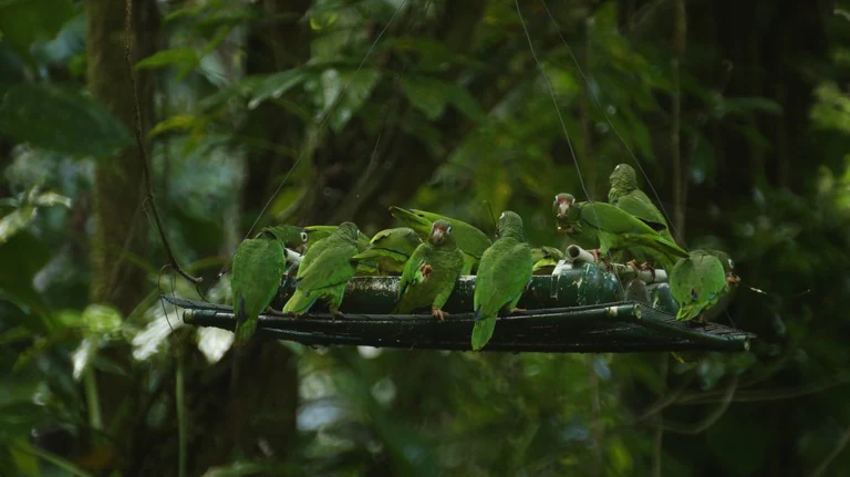
Several bright green parrots perched on a dark, horizontal feeding platform in a lush, dense forest setting.
A group of Puerto Rican parrots feeding at an aviary station within the Río Abajo State Forest.

Río Abajo State Forest history and protected-area timeline

The forest area saw substantial development during the twentieth century, when the Civilian Conservation Corps carried out much of the early roadbuilding, infrastructure, and trail work that shaped the present reserve. In 1943, the Puerto Rico Reconstruction Administration formally designated Río Abajo as one of five forests intended to protect and consolidate the remaining forested areas of the island.

Logging-era roads later became the hiking trails that visitors use today. Over time, recognition of the forest's ecological and geological value grew, and in 1980 the United States Department of Interior designated Río Abajo a National Natural Landmark, citing it as an ideal representation of karstic ecosystems in Puerto Rico and the wider Caribbean.

The forest also became a focal point for wildlife recovery beginning in 1983, when the Puerto Rico Department of Natural and Environmental Resources, working with the U.S. Fish and Wildlife Service, began reintroducing captive-bred Puerto Rican parrots into the area. The establishment of the José Luis Vivaldi Lugo Aviary cemented the reserve's role as a captive breeding and release site, and ongoing releases have built up the largest wild population of the species outside its other historic range.

Río Abajo State Forest landscape and geographic character

Río Abajo State Forest lies within the Montebello karst, a portion of the Cibao formation that defines the Northern Karst zone of Puerto Rico. The reserve's most prominent landforms are mogotes: steep, isolated hills of limestone that have resisted erosion while the surrounding rock dissolved away, leaving them standing as dramatic conical and tower-like outcrops scattered across the landscape.

Between and around the mogotes, the terrain is punctuated by sinkholes, dry and water-filled dolines, narrow canyons, and shadowy ravines that channel flow underground through the karst system. Caves are a recurring feature, with examples such as Cueva del Agua and Cueva Alta accessible within the forest limits, and the broader area offers additional cave attractions nearby, including Cueva Ventana.

The karst substrate also produces one of the forest's most notable geological features: a clear exposure of the Eocene to Oligocene unconformity, a break in the rock record visible at only a handful of sites on the island. Together, the surface relief and the underground drainage network give the forest a topography that feels unusually broken and three-dimensional, with nearly every ridge overlooking a depression or cliff.

Río Abajo State Forest ecosystems, habitats, and plant life

The vegetation of Río Abajo is dominated by subtropical wet and moist karst forest, a dense and structurally complex forest type adapted to limestone soils, rapid internal drainage, and frequent moisture. The canopy and understory together host more than 175 tree species, giving the forest an unusually high floristic richness for a relatively compact protected area.

Around 47 of these tree species are considered endangered or threatened, and the forest supports several trees specialized to limestone habitats, including Daphnopsis hellerana, erubia, palo de rosa, and the critically endangered nigua. More common canopy species include ceiba, algarrobo, jobo, maga, tabaiba, cohoba, and white fiddlewood, contributing to a mixed forest mosaic rather than a single uniform stand.

The combination of varied microhabitats on mogote slopes, in sinkholes, along ravines, and at cave mouths creates strongly contrasting light, moisture, and soil conditions across short distances. This habitat diversity is central to the forest's biodiversity, supporting a wide range of plant communities and providing refuges for species that cannot survive in more uniform lowland forest.

Río Abajo State Forest wildlife and species highlights

The forest's wildlife profile is dominated by birds, with more than 34 documented species ranging across endemic, resident, and migratory groups. Notable residents include the Puerto Rican euphonia, Puerto Rican vireo, Puerto Rican emerald, and Puerto Rican spindalis, all birds found only in the Puerto Rico archipelago.

The reserve provides key protected habitat for the endangered Puerto Rican broad-winged hawk, with an estimated population of roughly sixty individuals in and around the forest. Reptiles also feature prominently, including the Puerto Rican boa, an endemic snake of conservation concern.

The most prominent wildlife story, however, is the recovery of the Puerto Rican parrot. Río Abajo has hosted reintroduction efforts for this critically endangered species since 1983, anchored by the José Luis Vivaldi Lugo Aviary, where birds are bred for eventual release. By the mid-2020s, the surrounding forest supported the largest wild population of the species, numbering roughly 270 to 290 individuals, a major milestone for one of the rarest parrots in the Americas.

Río Abajo State Forest conservation status and protection priorities

Río Abajo State Forest's conservation significance operates at multiple scales. At the landscape scale, it protects a substantial block of northern karst forest that is otherwise increasingly fragmented by development, agriculture, and infrastructure in surrounding municipalities. Its location within the Arecibo River basin gives it additional watershed value, helping to maintain forest cover and infiltration across a hydrologically important area.

Recognition as a U.S. National Natural Landmark in 1980 highlighted the reserve's standing as a benchmark example of Caribbean karst ecosystems, a designation that underscores both its geological and its ecological representativeness at the regional level.

Beyond passive protection, the forest is an active conservation site. It has functioned since 1983 as a reintroduction site for the Puerto Rican parrot, run jointly by the Puerto Rico Department of Natural and Environmental Resources and the U.S. Fish and Wildlife Service. The on-site aviary, continued releases, and steady growth of the wild population have turned the forest into a flagship site for Caribbean endangered species recovery, while its National Natural Landmark status continues to anchor its role in karst ecosystem conservation.

Río Abajo State Forest cultural meaning and human context

The forest takes in more than just natural values; it also contains a number of archaeological sites, suggesting long-standing human presence and use of these lands, even if the reserve itself is primarily framed around its natural features. The surrounding municipalities of Arecibo and Utuado, including the nearby Caguana area, are known for pre-Columbian heritage and ceremonial sites, situating the forest within a broader landscape of indigenous and rural cultural history.

Twentieth-century response to environmental pressures also left a visible mark: the Civilian Conservation Corps and earlier logging operations shaped the existing road and trail network, a legacy that turns what was once resource extraction into today's recreational and educational infrastructure. The forest's name itself, drawn from a local Utuado barrio, reflects the way protected areas here remain embedded in longstanding community geography.

Top sights and standout views in Río Abajo State Forest

Río Abajo's strongest draws are its karst landscape, its endemic birdlife, and its global role in the recovery of the Puerto Rican parrot. Mogote hills, sinkholes, and accessible cave systems give the forest a distinctive terrain that very few other protected areas in the Caribbean can match at this scale. The on-site breeding aviary and the surrounding wild parrot population offer a rare chance to see one of the world's rarest parrots in its native forest setting. Layered on top of these features, more than seventy trails converted from historic roads make the reserve unusually accessible for hiking, birdwatching, and cave exploration within a single protected unit.

Best time to visit Río Abajo State Forest

The forest's climate is consistently warm and humid, with subtropical wet and moist forest character dominating year-round. Visits in the cooler and slightly drier winter and early spring months tend to be more comfortable for hiking the extensive trail network, while the lush green character of the wetter summer season emphasizes the forest's dense vegetation and active karst drainage. Birdwatching and parrot-related interest can justify visits at any time of year, though periods following extended dry spells can make the trail surface more comfortable and the caves more accessible.
Monthly climate preview

Long-term temperature and precipitation averages recorded at representative coordinates

Río Abajo State Forest Climate Normals and Monthly Weather Patterns

Representative coordinate records show measured monthly temperature and precipitation normals for Río Abajo State Forest from 1991 to 2020. Examining the full monthly climatology profile reveals complete seasonal temperature ranges and precipitation rhythms across the protected area.
Annual mean27 °C
25 °C28 °C
Jan25°
Feb25°
Mar25°
Apr26°
May27°
Jun27°
Jul28°
Aug28°
Sep28°
Oct27°
Nov26°
Dec26°
Warmest month
August

27.9 °C

Coolest month
January

25 °C

Wettest month
September

5.7 mm/day

Driest month
February

1.9 mm/day

Park location guide

Geography guide, regional context, and park location map for Río Abajo State Forest

Río Abajo State Forest park geography, regions, and map view in United States of America

Understand where Río Abajo State Forest sits in United States of America through a broader geographic reading of the surrounding landscape, nearby location context, and its mapped position within the national park landscape.

How Río Abajo State Forest fits into United States of America

The United States of America is a federal presidential republic and one of the world's largest countries by area and population. It consists of 50 states across a vast territory spanning multiple time zones, with its capital in Washington, D.C. and largest city in New York City. The nation has a diverse economy, influential political system, and significant cultural and military presence globally.

Wider geography shaping Río Abajo State Forest in United States of America

The United States occupies a vast territory in North America, bordered by Canada to the north and Mexico to the south. The 48 contiguous states stretch from the Atlantic to the Pacific Ocean, while Alaska occupies the northwestern region and Hawaii is an archipelago in the Pacific. The country encompasses diverse terrain including the Rocky Mountains, Appalachian Mountains, Great Plains, and extensive river systems.

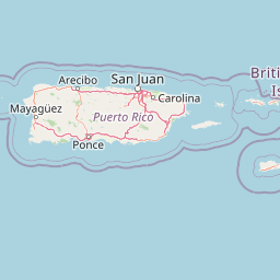
Map view of Río Abajo State Forest

Use this park location map to pinpoint Río Abajo State Forest in United States of America, understand its exact geographic position, and read its mapped placement within the surrounding landscape more clearly.

Pigeon | © OpenStreetMap contributors

Visualizing the karst terrain, mogote hills, and subtropical forest habitats

Río Abajo State Forest Photos and Landscape Scenery Exploration

Photographic collections reveal the dramatic limestone topography, steep conical hills, and sinkhole networks defining Río Abajo State Forest. Visual exploration helps observers examine the native habitats and protected-area environments supporting endangered regional wildlife.

Several bright green parrots perched on a dark, horizontal feeding platform in a lush, dense forest setting.

Park atlas

Compare regional protected areas and discover surrounding Caribbean karst terrain.

Explore Other Parks Near Río Abajo State Forest and Connected Protected Landscapes

Browse protected areas near Río Abajo State Forest to compare regional karst geography and surrounding natural reserves. This broader park exploration connects distinct limestone landscapes across the northern conservation corridor.
A wide watercolor illustration showing a forest scene with trees in the foreground, a winding path or river, and green hills in the background.
Nature reservePuerto Rico
About 16 km away#1 closest

Northeast

Cambalache Forest Reserve: A Detailed Look at Northern Puerto Rico Karst Geography

Protected karst landscape and forest mosaic

Focusing on the rugged limestone mogotes that define the Northern Karst Belt, Cambalache Forest Reserve serves as a vital protected area for endemic flora and fauna. This record provides geographic context on its low-elevation forest structure, the ecological significance of its varied microclimates, and its role as a persistent research site since the mid-twentieth century.

Established
1943
Relief
Upland
Access
Easy access
Scope
Terrestrial
Protected areaAdjuntas
About 18 km away#2 closest

South

Bosque del Pueblo: Protected Forest Geography and Cordillera Central Landscape

A mountain watershed and ecological corridor in Adjuntas

Bosque del Pueblo represents a key protected landscape within the central mountains of Puerto Rico. As a critical forest reserve located in Adjuntas, it preserves headwaters and supports rare bird populations, serving as a permanent ecological link between several major state forest units.

Area
2.987 km²
Established
1995
Relief
Mountain
Climate
Tropical
State or regional parkPuerto Rico
About 22 km away#3 closest

Southeast

Los Tres Picachos State Forest: A Geographic Guide to Puerto Rico's Mountain Protected Areas

Cloud forests, volcanic terrain, and watershed protection

Los Tres Picachos State Forest encompasses a striking landscape in the Puerto Rican interior, marked by deep river valleys and its namesake triple peaks. This atlas feature provides insights into the forest's layered ecological zones and its role as a crucial hydrological anchor for the Toro Negro and Cialitos river systems within the Cordillera Central.

Established
1999
Relief
Mountain
Climate
Tropical
Access
Remote access
State or regional parkPuerto Rico
About 26 km away#4 closest

South

Guilarte State Forest: Protected Mountain Ecosystems and Cordillera Central Geography

Highland conservation and mapped mountain terrain in central Puerto Rico

Guilarte State Forest represents a essential protected area in the Cordillera Central of Puerto Rico. The reserve encompasses steep altitudinal shifts, ranging from mid-slope palm forests to summit-level cloud forests. As a headwater region for major river basins, the forest is a focal point for understanding the island's mountainous geography and conservation priorities for endemic species.

Area
19.514 km²
Established
1935
Relief
Mountain
Climate
Tropical
A soft watercolor illustration of green hills and foliage against a pale background.
State or regional parkPuerto Rico
About 30 km away#5 closest

West

Guajataca State Forest: Geography and Protected Karst Landscapes in Puerto Rico

Explore the mogotes and cave systems of this regional forest

Guajataca State Forest protects a significant limestone karst landscape in northwestern Puerto Rico. The area is defined by its conical mogote hills, deep sinkhole drainage, and complex cave networks, including the notable Cueva del Viento. As a key part of the regional forest system, it offers a window into the geological and ecological makeup of the Northern Karst belt.

Area
9.26 km²
Established
1943
Relief
Upland
Climate
Tropical
Watercolor painting of a hilly, green landscape featuring rolling mountains in the distance and vegetation in the foreground.
State or regional parkUnited States of America
About 31 km away#6 closest

Southeast

Cerrillos State Forest: Protected Subtropical Woodland and Reservoir Geography

Foothill landscapes and watershed features in Ponce, Puerto Rico

This protected area features a mix of tabonuco forest and water-based recreational terrain. Spanning the slopes of the Cordillera Central foothills, the forest encompasses the Cerrillos River and the man-made Lake Cerrillos reservoir, offering a distinct example of subtropical moist forest ecology within the United States commonwealth system.

Area
0.79 km²
Established
1996
Relief
Upland
Climate
Subtropical
State or regional parkPuerto Rico
About 38 km away#7 closest

Southwest

Maricao State Forest: A Detailed Map and Geographic Overview of Puerto Rico's Mountain Wilderness

Endemic-rich mountain forests and serpentinite terrain in the Cordillera Central

Maricao State Forest represents a vital protected landscape in the western Cordillera Central of Puerto Rico. This site features distinctive serpentinite geology, complex mountainous watersheds, and diverse endemic bird habitats. The forest serves as a primary geographic anchor along the Ruta Panorámica, providing clear insight into the rugged environmental character of the central island spine.

Area
43.72 km²
Established
1919
Relief
Mountain
Climate
Tropical
Watercolor painting of a coastal dry forest scene with mangrove-like trees and hills in the background.
State or regional parkPuerto Rico
About 46 km away#8 closest

Southwest

Guánica State Forest: Mapped Geography and Protected Landscapes in Puerto Rico

A diverse Caribbean subtropical dry forest reserve spanning karst terrain and coastal habitats

Guánica State Forest serves as a primary protected natural area in southwestern Puerto Rico, defined by its arid subtropical climate and exceptional ecological diversity. This reserve incorporates a complex mosaic of ecosystems, including deciduous dry forest, mangrove channels, salt flats, and offshore keys. The landscape provides critical habitat for numerous endemic species while preserving the integrity of the Southern Karst geological zone and its surrounding maritime boundaries.

Area
39.97 km²
Established
1919
Relief
Lowland
Climate
Tropical

Common questions about visiting, size, designation, and location context for Río Abajo State Forest

Río Abajo State Forest FAQs for park facts, access, geography, and protected area context

Find quick answers about Río Abajo State Forest, including protected-area facts, park geography, trail and visitor context, and how the park fits into its surrounding country and regional landscape.
MoriAtlas Explorer

Continue Your Protected Areas Search Across the Global Atlas

Deepen your exploration by continuing the structured search for national parks and protected areas worldwide. Utilize the comprehensive filtering capabilities to compare different conservation landscapes and refine your understanding of global park geography. Discover more about the distribution and characteristics of protected natural areas.

Global natural geography