

Mori Atlas logo
Wildlife reserveRita Blanca National Grassland

A mosaic of federal prairie parcels across the high plains of Texas and Oklahoma

Rita Blanca National Grassland: Mapping the Protected Shortgrass Prairie of the Texas Panhandle

Rita Blanca National Grassland encompasses a unique patchwork of native prairie fragments woven across the high plains of the Texas Panhandle and the Oklahoma Panhandle. This protected landscape, established as a recovery response to the Dust Bowl era, preserves semi-arid shortgrass terrain ranging from 3,700 to 4,700 feet in elevation. The area remains a crucial example of fragmented grassland conservation, where federal parcels exist in a checkerboard pattern among working ranches and farms to support native plains habitat.

shortgrass prairieGreat PlainsTexas PanhandleOklahoma Panhandlenational grasslandpronghorn habitat

Rita Blanca National Grassland

Wildlife reserve

Park overview

Structured park overview, official facts, and landscape profile for Rita Blanca National Grassland

Rita Blanca National Grassland park facts, protected area profile, and essential visitor context

Review the core facts for Rita Blanca National Grassland, including designation, size, terrain, visitor scale, habitats, and operating context in one park-focused overview.

About Rita Blanca National Grassland

Rita Blanca National Grassland is a National Grassland unit of the U.S. Forest Service, sitting on the high plains where northwestern Texas meets the western tip of Oklahoma. The protected area lies in the Texas Panhandle and the Oklahoma Panhandle, anchored in northwestern Dallam County, Texas, and southern Cimarron County, Oklahoma, with Texline as the closest small community and Dalhart as the principal nearby city. The grassland exists within a sweeping semi-arid landscape shaped by wind, sparse rainfall, and the deep topsoil of the Great Plains.

Unlike many national parks or wilderness blocks, Rita Blanca is not a single fenced sanctuary. Its protected parcels are scattered across the rural landscape and interspersed with privately owned ranch and farm land. This checkerboard pattern reflects the way the grassland was assembled: through federal acquisition of failed cropland during and after the Dust Bowl, rather than the designation of a single untouched tract. The result is a working landscape in which native shortgrass prairie, grazing lands, and human land use coexist across the same broad region.

Ecologically, the grassland is defined by its shortgrass prairie vegetation and its elevation, which rises from roughly 3,700 feet in southeastern Dallam County to about 4,700 feet in northwestern Cimarron County. The grassland supports pronghorn, prairie dogs, rabbits, coyotes, and a variety of predatory birds, and broader ecological surveys have documented hundreds of plant species across the unit. Administratively, Rita Blanca is grouped with Kiowa, Black Kettle, and McClellan Creek National Grasslands under the Cibola National Forest, with local ranger district offices in Clayton, New Mexico, and overall headquarters in Albuquerque.

Quick facts and research context for Rita Blanca National Grassland

Rita Blanca National Grassland covers approximately 92,989 acres (about 376 square kilometers), with the great majority, around 77,463 acres, in Texas and roughly 15,860 acres in Oklahoma. It lies in the high plains of the Texas Panhandle and Oklahoma Panhandle, with elevations ranging from roughly 3,700 to 4,700 feet. The land is managed by the U.S. Forest Service as part of the Cibola National Forest administrative umbrella, which also oversees Black Kettle, Kiowa, and McClellan Creek National Grasslands.

Protection and recognition

Documented terrestrial protection scope and transboundary park characteristics.

Rita Blanca National Grassland Protection Status and Recognition Data

Rita Blanca National Grassland encompasses documented terrestrial protection scope and transboundary geographic characteristics. Public protection status and official designation records provide clear context for conservation management.

Protection details

Protection scope
Terrestrial
Transboundary protection
Yes
Park context

Deeper park guide and search-rich context for Rita Blanca National Grassland

Rita Blanca National Grassland history, landscape, wildlife, and travel context

Explore Rita Blanca National Grassland through its history, landscape character, ecosystems, wildlife, conservation priorities, cultural context, and seasonal travel timing in a structured park guide built for atlas discovery and search intent.

Why Rita Blanca National Grassland stands out

Rita Blanca National Grassland is best known for its restored shortgrass prairie on the southern Great Plains and its identity as one of the Dust Bowl era reclamation grasslands. It stands out for its mosaic of public native prairie parcels interlaced with private ranchland, its semi-arid climate, and its role as habitat for pronghorn, prairie dogs, coyotes, and raptors.
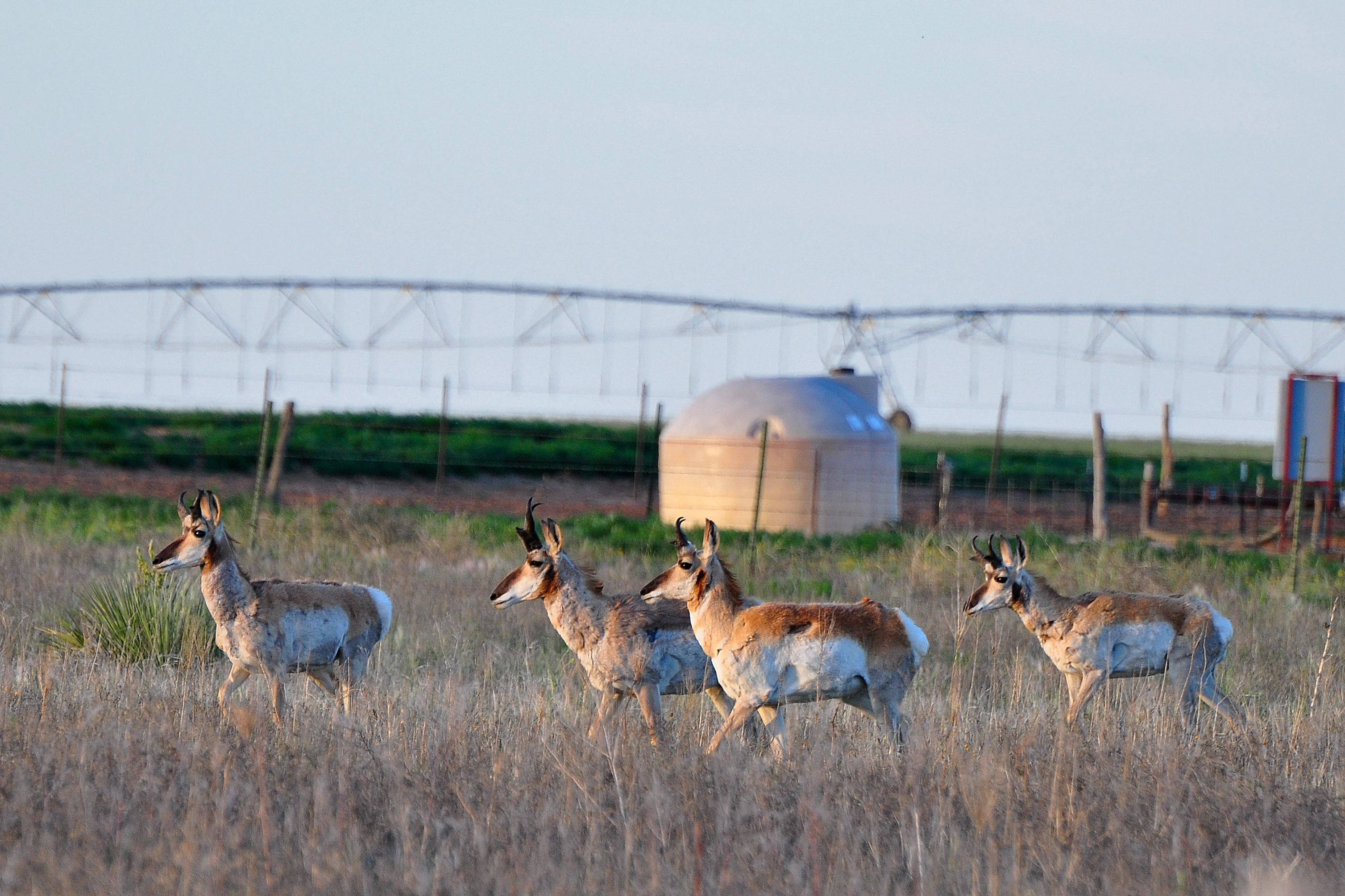
Pronghorn in Rita Blanca National Grassland
A pronghorn Antilocapra americana residing in the Rita Blanca National Grassland, Texas.

Rita Blanca National Grassland history and protected-area timeline

Rita Blanca National Grassland owes its existence to one of the defining environmental crises of 20th-century North America: the Dust Bowl of the 1930s. Across the southern Great Plains, decades of intensive plowing combined with severe drought turned cropland into a source of catastrophic wind erosion. The federal government responded with a series of programs aimed at retiring damaged land and restoring native grassland cover.

The National Industrial Recovery Act of 1933 and the Emergency Relief Appropriations Act of 1935 gave federal agencies the authority to purchase failed cropland, while the Bankhead-Jones Farm Tenant Act of 1937 authorized the transfer of roughly 3,850,000 acres to the Soil Conservation Service for restoration and protection. Together, these measures laid the groundwork for what would eventually become a network of National Grasslands in the plains states. Rita Blanca and its sister unit, Kiowa National Grassland in New Mexico, were formally established when Congress approved their creation in 1960.

The name "Rita Blanca" translates roughly as "Little White River" and was originally applied by 19th-century Spanish sheepherders to a stream in the region. The name was later adopted by the historic XIT Ranch and has since been applied to other geographic features in the surrounding landscape, giving the grassland a cultural anchor in the layered ranching and Hispanic pastoral history of the Panhandle.

Rita Blanca National Grassland landscape and geographic character

Rita Blanca National Grassland sits on a high, gently undulating section of the Great Plains. Elevations climb gradually from roughly 3,700 feet in southeastern Dallam County, Texas, to about 4,700 feet in northwestern Cimarron County, Oklahoma, giving the landscape a quiet, sloping character rather than dramatic relief. The terrain reads as open prairie, with broad horizons, shallow drainages, and a sense of vast sky typical of the southern plains.

The grassland is not a single contiguous tract of public land. Instead, the U.S. Forest Service parcels form a patchwork of native prairie fragments interlaced with privately owned ranch and farmland. This fragmented mosaic softens the boundary between protected and working land and gives the area a more human-scaled feel than a consolidated wilderness block. The semi-arid climate defines the surface itself, supporting the tough, low-growing shortgrass vegetation that has historically held the plains together against wind and drought.
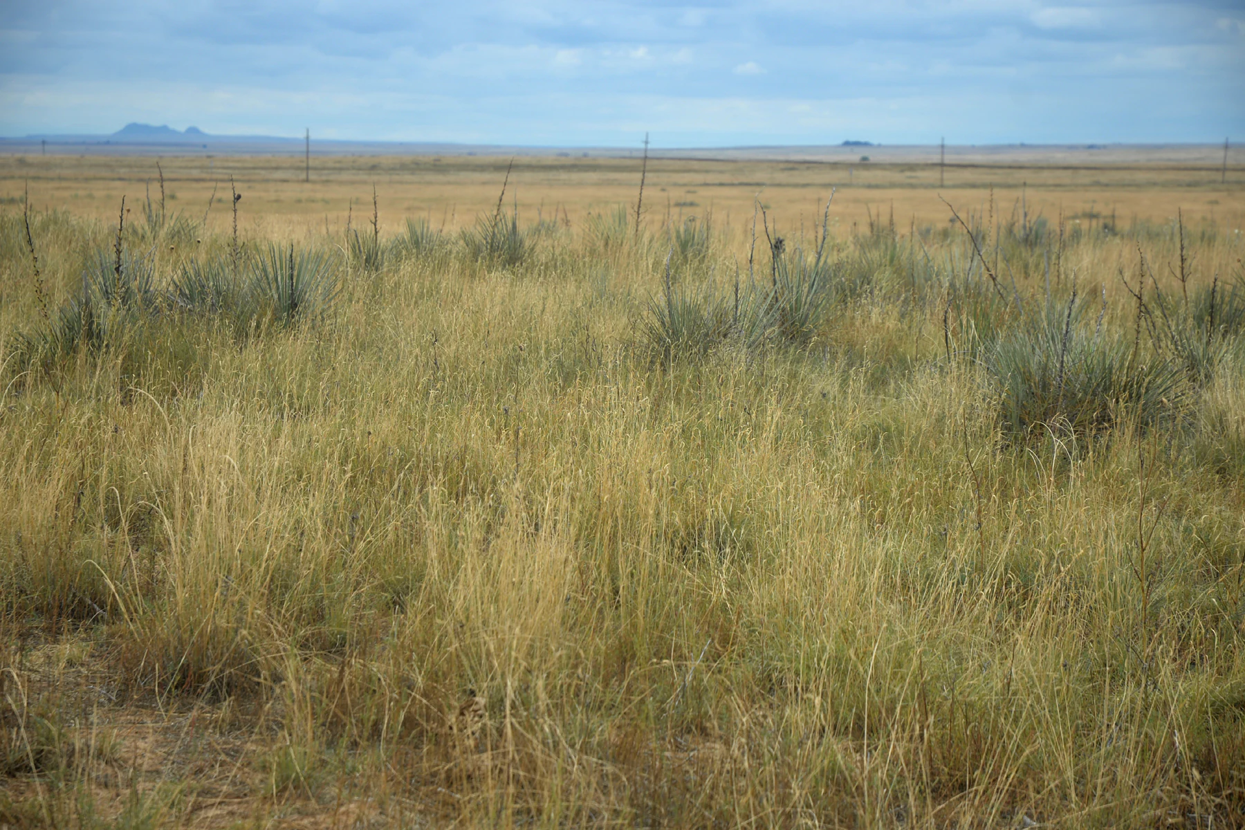
Rita Blanca National Grassland from West High Lonesome Lane
View of Rita Blanca National Grassland from West High Lonesome Lane in Dallam County, Texas.

Rita Blanca National Grassland ecosystems, habitats, and plant life

The grassland's ecological identity is rooted in shortgrass prairie, a vegetation type adapted to low rainfall, strong winds, and the heavy but erosion-prone soils of the southern plains. Bunchgrasses and other low-stature plants dominate, forming a continuous ground cover that resists the kind of wind erosion that devastated the region during the Dust Bowl. The mosaic of public parcels and surrounding ranch land means that the broader landscape also includes a mix of native prairie, introduced pasture, and cropland, creating transitional edges that shape local habitat patterns.

Ecological surveys of the Kiowa and Rita Blanca grasslands have documented a striking richness within these seemingly simple landscapes, including hundreds of vascular plant species across dozens of families. This diversity reflects the subtle variation in soils, slopes, and moisture across the plains, even where the visual impression from the road is one of uniform grass and sky. The semi-arid climate, summer-dominant rainfall, and open exposure all combine to produce a distinctive prairie ecosystem quite different from the mixed-grass or tallgrass prairies found farther east.
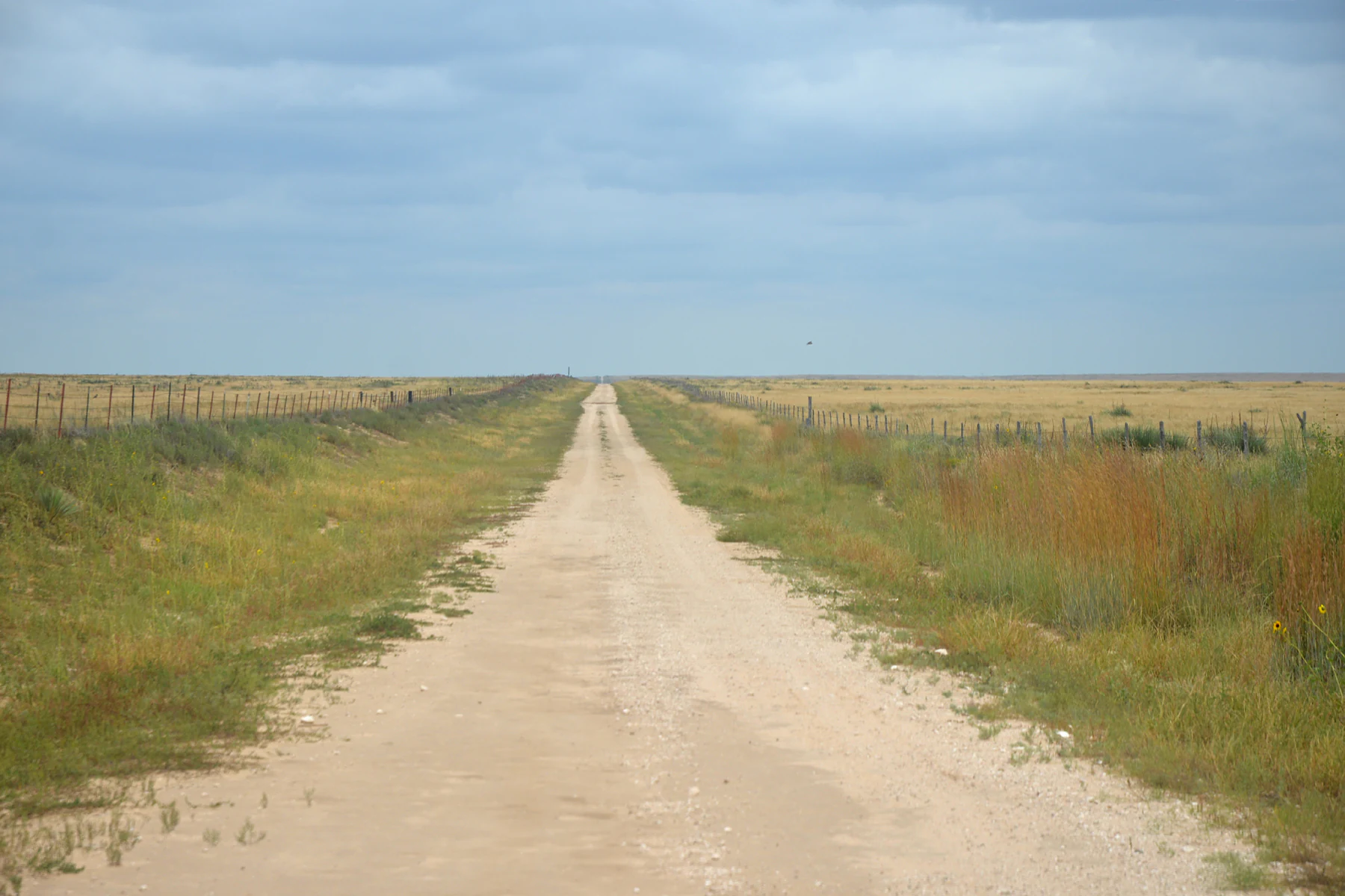
West High Lonesome Lane
West High Lonesome Lane passing through the Rita Blanca National Grassland in Dallam County, Texas.

Rita Blanca National Grassland wildlife and species highlights

Pronghorn are among the most visible and emblematic animals of Rita Blanca National Grassland, moving across the open terrain in a way that reflects the unit's identity as a working prairie refuge. Prairie dogs form another signature presence, contributing to the broader food web of the plains. Coyotes, rabbits, and a variety of predatory birds round out the wildlife community the grassland is best known for, with raptors using the open landscape for hunting.

The mix of public native prairie and surrounding private land has historically supported both resident wildlife and animals that range more widely across the Panhandle. The grassland's openness, low vegetation height, and semi-arid climate favor species adapted to grasslands and shrublands rather than forests, and the area is often appreciated by visitors as one of the easternmost points where this kind of southern shortgrass prairie fauna remains relatively intact.
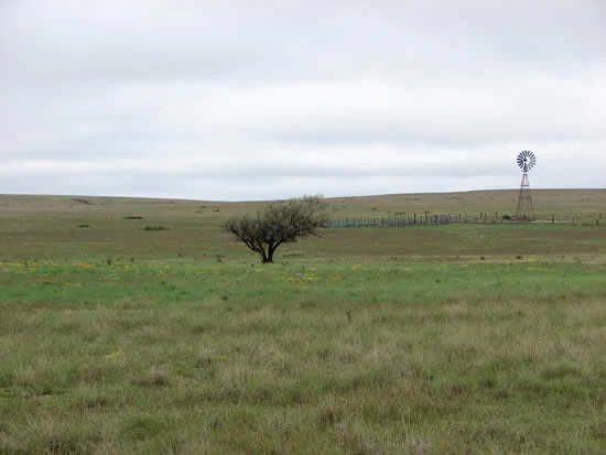
Hackberry tree in Rita Blanca National Grassland
A solitary hackberry tree surrounded by blue grama grass within the Rita Blanca National Grassland.

Rita Blanca National Grassland conservation status and protection priorities

Rita Blanca National Grassland is fundamentally a conservation landscape born out of failure. Its establishment is directly tied to the Dust Bowl, the great wind erosion disaster that demonstrated how completely the native shortgrass prairie had once protected the southern plains. Federal acquisition of failed cropland in the 1930s and the creation of National Grasslands under the Bankhead-Jones framework represented a deliberate shift away from treating every acre of plains as potential farmland and toward preserving native grassland cover for soil protection and ecological value.

Today, the grassland's conservation role centers on maintaining native shortgrass prairie, providing habitat for species such as pronghorn and prairie dogs, and demonstrating how restored prairie can coexist with surrounding ranching and farming. By being a mosaic of federal parcels and private land rather than a closed reserve, Rita Blanca also serves as a working example of how conservation on the Great Plains depends on cooperation with the agricultural community that surrounds it.

Rita Blanca National Grassland cultural meaning and human context

The name "Rita Blanca" connects the grassland to an older cultural layer of the southern plains. The phrase, meaning roughly "Little White River," was first applied to a local stream by 19th-century Spanish sheepherders and later carried into the regional ranching vocabulary by the historic XIT Ranch, one of the most storied cattle operations in Texas history. The same name has since been applied to other geographic features in the vicinity, threading Hispanic pastoral heritage, large-scale ranching, and modern conservation into a single landscape identity.

The presence of the XIT Museum in nearby Dalhart, Texas, underscores how closely the grassland and its surroundings are tied to the ranching heritage of the Panhandle. The cultural context of Rita Blanca is therefore not a remote wilderness story but a plains story, one of grazing, drought, dust, and the long effort to keep the native prairie alive alongside working ranches and farms.

Top sights and standout views in Rita Blanca National Grassland

Rita Blanca National Grassland offers a distinctive piece of southern Great Plains prairie, restored and protected as a direct response to the Dust Bowl. Its checkerboard of federal native prairie parcels interlaced with private ranchland gives it a uniquely working-plains character. The grassland supports pronghorn, prairie dogs, coyotes, and raptors across a semi-arid shortgrass landscape that climbs from roughly 3,700 to 4,700 feet, and it sits within a broader network of National Grasslands managed by the Cibola National Forest.

Best time to visit Rita Blanca National Grassland

The character of Rita Blanca National Grassland shifts with the rhythm of the southern plains. Spring and early summer bring green-up to the shortgrass prairie, mild temperatures, and the most active wildlife viewing, including pronghorn movement and raptor activity. Late summer can be hot and dry, with thunderstorms rolling across the open sky. Fall offers cooler weather, golden grass tones, and a quieter atmosphere. Winters are generally dry and can be cold, with open landscapes that feel even more exposed. Because the grassland is administered as multiple small parcels across working ranchland, broad seasonal awareness is more relevant here than pinpoint monthly planning.
Monthly climate preview

Long-term representative temperature and precipitation records across twelve recorded intervals

Rita Blanca National Grassland Climate Normals and Monthly Weather Patterns

Representative coordinate sampling reveals the measured annual temperature and precipitation rhythm across Rita Blanca National Grassland, establishing baseline normals from 1991 to 2020. Examining the complete monthly climate profile provides deeper context on long-term thermal variations and precipitation distribution.
Annual mean14 °C
2 °C27 °C
Jan
Feb
Mar
Apr13°
May19°
Jun25°
Jul27°
Aug25°
Sep21°
Oct14°
Nov
Dec
Warmest month
July

26.9 °C

Coolest month
December

2.1 °C

Wettest month
August

2.3 mm/day

Driest month
January

0.4 mm/day

Park location guide

Geography guide, regional context, and park location map for Rita Blanca National Grassland

Rita Blanca National Grassland park geography, regions, and map view in United States of America

Understand where Rita Blanca National Grassland sits in United States of America through a broader geographic reading of the surrounding landscape, nearby location context, and its mapped position within the national park landscape.

How Rita Blanca National Grassland fits into United States of America

The United States of America is a federal presidential republic and one of the world's largest countries by area and population. It consists of 50 states across a vast territory spanning multiple time zones, with its capital in Washington, D.C. and largest city in New York City. The nation has a diverse economy, influential political system, and significant cultural and military presence globally.

Wider geography shaping Rita Blanca National Grassland in United States of America

The United States occupies a vast territory in North America, bordered by Canada to the north and Mexico to the south. The 48 contiguous states stretch from the Atlantic to the Pacific Ocean, while Alaska occupies the northwestern region and Hawaii is an archipelago in the Pacific. The country encompasses diverse terrain including the Rocky Mountains, Appalachian Mountains, Great Plains, and extensive river systems.

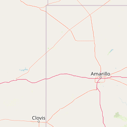
Map view of Rita Blanca National Grassland

Use this park location map to pinpoint Rita Blanca National Grassland in United States of America, understand its exact geographic position, and read its mapped placement within the surrounding landscape more clearly.

Pigeon | © OpenStreetMap contributors

Location context for Rita Blanca National Grassland

OklahomaTexas
Recorded earthquake history

Explore the Historical Earthquake Catalogue for Rita Blanca National Grassland

Discover a detailed record of seismic events associated with the geography of Rita Blanca National Grassland. This database allows for the analysis of regional historical tremors, providing researchers with magnitude and distance data compiled by MoriAtlas for consistent, fact-based geographic exploration of the Great Plains.

Rita Blanca National Grassland Earthquake History

Catalogued events

4 events

Strongest magnitude

Magnitude 3.9

Most recent event

Mar 31, 2022

This history includes earthquakes recorded inside the park or within 50 km of its borders

Visual exploration of shortgrass prairie terrain and protected habitats

Rita Blanca National Grassland Photos and Scenery

Visual records capture the open horizons, undulating shortgrass plains, and scattered wildlife habitats defining Rita Blanca National Grassland. Photographic documentation helps visitors understand the protected terrain, semi-arid vegetation, and regional character of the southern Great Plains.

Pronghorn in Rita Blanca National Grassland

Rita Blanca National Grassland welcome sign

Rita Blanca National Grassland from West High Lonesome Lane

West High Lonesome Lane

Hackberry tree in Rita Blanca National Grassland

Park atlas

Compare surrounding high plains terrain and connected regional grassland ecosystems

Parks Near Rita Blanca National Grassland and Regional Protected Areas

Browse other parks near Rita Blanca National Grassland to examine related protected landscapes across the high plains. Comparing surrounding regional reserves provides deeper geographic context for southern Great Plains ecosystems.
Protected landscapeNew Mexico
0 km away#1 closest

West

Kiowa National Grassland: Protected Landscapes, Canyon Terrain, and Prairie Geography

Northeastern New Mexico shortgrass prairie and river canyon systems.

Kiowa National Grassland represents a distinctive protected landscape within the southwestern Great Plains, featuring a mix of rolling steppe, pinyon-juniper woodland, and the deep gorges of the Canadian River Canyon. This area offers significant insight into the regional geography of New Mexico, where historic Santa Fe Trail corridors and seasonal playa lakes define the local terrain and ecosystem.

Area
554.95 km²
Established
1960
Relief
Upland
Climate
Temperate
Protected areaColorado
46 km away#2 closest

Northwest

Comanche National Grassland: Geographic Atlas of Southeastern Colorado Protected Plains

Exploring canyon systems and prairie landscape boundaries

Spanning across Baca, Otero, and Las Animas counties, Comanche National Grassland represents a distinctive protected landscape of shortgrass prairie and deep canyon networks. The region is marked by the dramatic Purgatoire River and Carrizo Creek systems, offering a rich study in semi-arid topography, riparian corridors, and fossil-rich geological formations within the Colorado plains.

Area
1,793.09 km²
Established
1960
Relief
Upland
Climate
Temperate
Protected areaKansas
61 km away#3 closest

Northeast

Cimarron National Grassland: Mapping the Largest Protected Area in Kansas

Shortgrass prairie geography and historical riparian landscapes

Spanning over 100,000 acres in southwestern Kansas, Cimarron National Grassland serves as a major ecological refuge within the Great Plains. The protected area features a unique terrain characterized by sand sagebrush uplands, cottonwood-forested bottomlands, and the winding course of the Cimarron River. This mapping data highlights the intersection of modern wildlife conservation and the remnants of the historic Santa Fe Trail.

Area
437.77 km²
Established
1960
Relief
Upland
Climate
Arid
Protected areaTexas
79 km away#4 closest

Southeast

Lake Meredith National Recreation Area: An Atlas Guide to Texas Panhandle Canyon Landscapes

Geography of the Canadian River reservoir and High Plains terrain

Analyze the topography of Lake Meredith National Recreation Area, where the Canadian River has sculpted deep canyons through the flat Texas High Plains. The site serves as a vital protected area for both water-based recreation and the preservation of arid, canyon-rim habitats near the Alibates Flint Quarries.

Area
182.02 km²
Established
1990
Visitors
1.3M annual
Relief
Upland
Protected landscapeTexas
170 km away#5 closest

Southeast

McClellan Creek National Grassland: Protected Landscape and Texas Geography Atlas

Restored shortgrass prairie and riparian reservoir geography

Located in the Texas Panhandle, McClellan Creek National Grassland serves as a critical example of soil conservation and shortgrass prairie restoration. The protected area features open, rolling plains surrounding the impounded McClellan Lake, providing a focused look at the environmental history and geographic character of the southern Great Plains.

Area
5.86 km²
Water
Minor water
Wildlife reserveUnited States of America
186 km away#6 closest

East

Black Kettle National Grassland: Protected Prairie Geography and Regional Map Context

A restored mixed-grass ecosystem in the southern Great Plains

Spanning scattered parcels in Oklahoma and Texas, Black Kettle National Grassland functions as a representative sample of restored southern plains prairie. The terrain consists of sandy soils, rocky red hills, and leafy draws along the Washita River headwaters. This protected area preserves a complex ecological and historical landscape that defines the character of the southern Great Plains, now managed for habitat restoration and natural resource protection.

Area
126.61 km²
Established
1960
Relief
Upland
Climate
Temperate
Protected landscapeColorado
192 km away#7 closest

Northwest

San Isabel National Forest: Geographic Overview and Protected Mountain Landscape Atlas

Central Colorado alpine terrain and designated wilderness areas

Spanning eleven counties in central Colorado, San Isabel National Forest serves as a cornerstone of the Southern Rocky Mountains. The forest landscape is dominated by the Sawatch and Sangre de Cristo ranges, offering a unique atlas of alpine tundra, dense coniferous forests, and high-altitude peaks that define the character of the region. This protected area provides a vital habitat and a vast, rugged environment characterized by volcanic formations like the Spanish Peaks and glacial geological features.

Area
4,533.42 km²
Established
1902
Relief
Mountain
Climate
Alpine
Protected landscapeNew Mexico
217 km away#8 closest

West

Santa Fe National Forest: Geographic Atlas and Protected Landscape Overview

New Mexico mountain geography and wilderness mapping

Santa Fe National Forest spans more than 1.5 million acres of Northern New Mexico, featuring a dramatic transition from canyon river systems to the high elevations of the Pecos Wilderness. This protected landscape contains a complex network of forest districts across the Jemez and Sangre de Cristo Mountains, defined by volcanic plateaus, alpine basins, and seasonal aspen forests. Use this resource to understand the park boundaries, regional mountain geography, and the interconnected nature of these protected lands.

Area
6,306.83 km²
Established
1915
Relief
Mountain
Access
Easy access

Common questions about visiting, size, designation, and location context for Rita Blanca National Grassland

Rita Blanca National Grassland FAQs for park facts, access, geography, and protected area context

Find quick answers about Rita Blanca National Grassland, including protected-area facts, park geography, trail and visitor context, and how the park fits into its surrounding country and regional landscape.
MoriAtlas Explorer

Continue Your Protected Areas Search Across the Global Atlas

Deepen your exploration by continuing the structured search for national parks and protected areas worldwide. Utilize the comprehensive filtering capabilities to compare different conservation landscapes and refine your understanding of global park geography. Discover more about the distribution and characteristics of protected natural areas.

Global natural geography