Mori Atlas logo
National parkRiver Gambia National Park

Discover the mapped boundaries and regional geography of this national park in Central River Division.

River Gambia National Park: Protected Landscape Geography and Map Context

River Gambia National Park stands as a protected landscape within the Central River Division of Gambia. This page offers detailed geographic context and explores the park's mapped boundaries, providing essential insights for atlas-driven discovery. Understand the regional setting and the physical geography that defines this important national park.

PrimatesRiparian ForestRiver IslandsChimpanzee ConservationWest AfricaProtected Islands
Illustrated river scene with sandy beach, palm trees, and calm water under pastel clouds

River Gambia National Park

National park

Park overview

Structured park overview, official facts, and landscape profile for River Gambia National Park

River Gambia National Park park facts, protected area profile, and essential visitor context
Review the core facts for River Gambia National Park, including designation, size, terrain, visitor scale, habitats, and operating context in one park-focused overview.

About River Gambia National Park

River Gambia National Park occupies a distinctive position within the Gambia's protected area network as a specialized conservation site focused on primates and riparian ecosystems. Located in the Niamina East district of the Central River Division, the park follows the left bank of the Gambia River and includes the Baboon Islands archipelago. The islands themselves represent a unique habitat type in the region, supporting tropical rainforest vegetation in the form of riparian forest that contrasts sharply with the surrounding savanna landscapes typical of central Gambia. The park's conservation mandate centers on protecting both the forest ecosystem and the chimpanzee population that has been established through decades of reintroduction work. Unlike the Gambia's other protected areas that welcome visitors, River Gambia National Park maintains restricted access to protect both the animals and potential visitors from aggressive chimpanzee behavior.

Quick facts and research context for River Gambia National Park

River Gambia National Park covers 585 hectares along the Gambia River in the Central River Division, approximately 13.64°N latitude. The park was established in 1978 and comprises the Baboon Islands archipelago. It is adjacent to Nyassang Forest Park and is not accessible to public visitation. The park hosts the Chimpanzee Rehabilitation Project, which has reintroduced chimpanzees to the islands since 1979 after the species became extinct in the Gambia in the early 20th century. As of 2006, approximately 77 chimpanzees lived across three of the larger islands.

Park context

Deeper park guide and search-rich context for River Gambia National Park

River Gambia National Park history, landscape, wildlife, and travel context
Explore River Gambia National Park through its history, landscape character, ecosystems, wildlife, conservation priorities, cultural context, and seasonal travel timing in a structured park guide built for atlas discovery and search intent.

Why River Gambia National Park stands out

River Gambia National Park is best known for its chimpanzee reintroduction program, one of the few such initiatives in West Africa. The Baboon Islands serve as a sanctuary for chimpanzees that have been rescued from the illegal wildlife trade and rehabilitated for life in the wild. The park also protects a rare pocket of tropical riparian forest within the Gambia, creating an ecological island habitat that supports multiple primate species including Guinea baboons, green monkeys, and western red colobus. The presence of Nile crocodiles, West African manatees, and hippopotamuses further distinguishes this protected area within the Gambia's conservation landscape.

Calm river with sandy shoreline, vegetation on the right side, and trees in the background under clear sky
River Gambia with sandy shoreline and vegetation along the bank

River Gambia National Park history and protected-area timeline

The park was established in 1978 as part of the Gambia's expanding protected area network. The chimpanzee rehabilitation program began in 1979 under the direction of Stella Marsden, daughter of Eddie Brewer, operating initially from the Baboon Islands after prior work at Abuko Nature Reserve. The program was created in response to the extinction of wild chimpanzees in the Gambia during the early 20th century, aiming to reintroduce primates confiscated from the illegal animal trade into appropriate habitat. Marsden was appointed Officer of the Order of the British Empire for her conservation work. Access to the islands has been progressively restricted, with boat traffic around the islands drastically reduced in 1998 following incidents of attempted chimpanzee theft. The park's institutional relationship with adjacent Nyassang Forest Park has led to their representation as a combined area on some cartographic materials.

River Gambia National Park landscape and geographic character

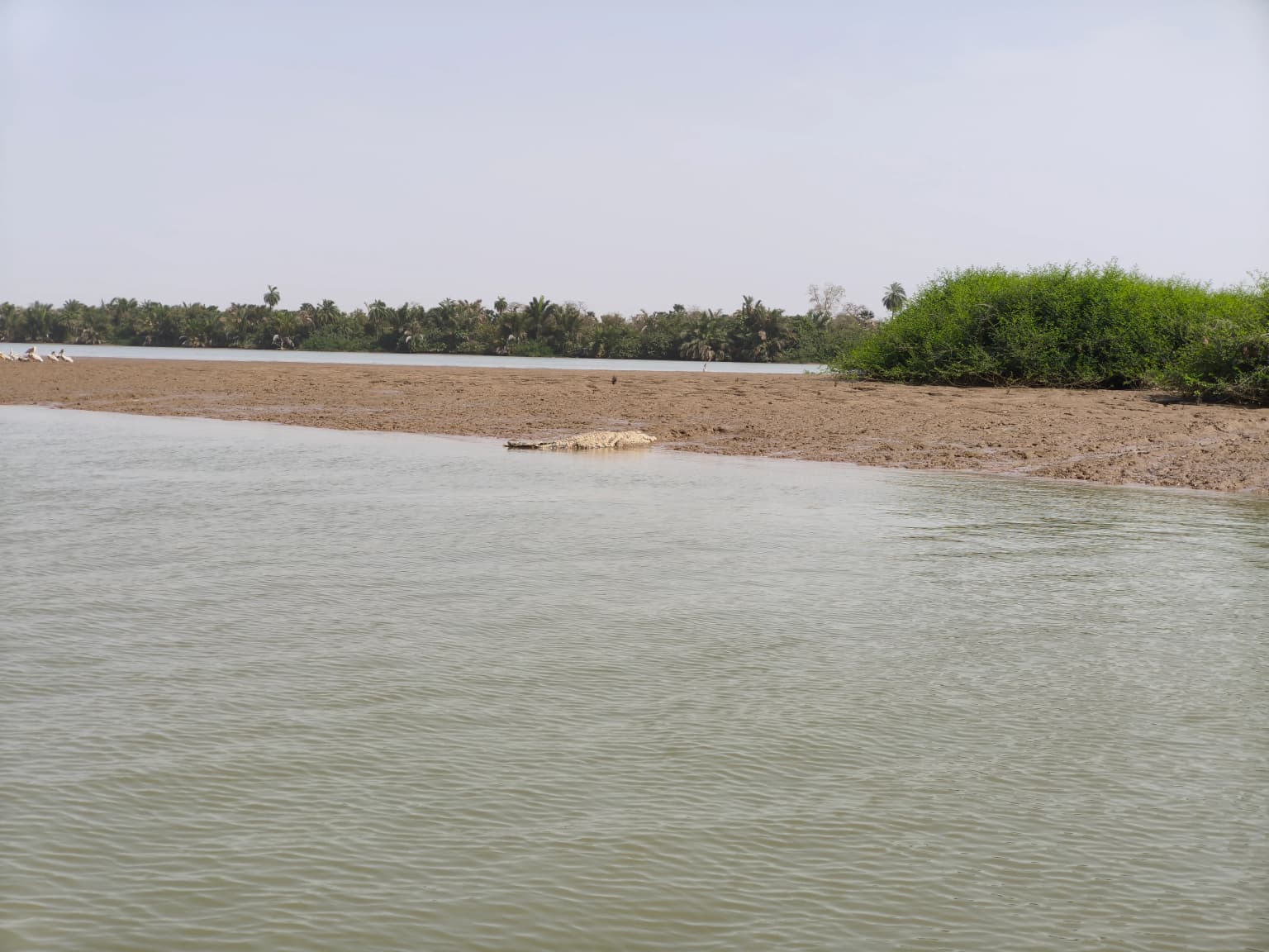
The park occupies a low-lying riverine setting along the Gambia River, characterized by flat terrain and the distinctive Baboon Islands archipelago. The islands range in size, with the three largest covering 435 hectares, 77 hectares, and 53 hectares respectively. The surrounding landscape consists of typical West African savanna, making the riparian forest of the islands a striking ecological contrast. The river itself forms a major geographic feature, providing aquatic habitat and defining the eastern boundary of the park. The flat topography of both the islands and the mainland portion reflects the general elevation characteristics of central Gambia, with the river valley creating the primary topographic variation in the area.

River Gambia National Park ecosystems, habitats, and plant life

The vegetation of River Gambia National Park represents a tropical rainforest ecosystem adapted to riparian conditions. The flat Baboon Islands support characteristic riparian forest that thrives along the river corridor, creating a dense green environment unlike the surrounding savanna landscapes. This forest type provides critical habitat for the park's primate populations and serves as a biodiversity refuge within the broader West African environment. The combination of island isolation and forest cover creates favorable conditions for species that require protected, undisturbed habitat. The park's ecological significance is amplified by its position as a forest island in a region where such habitat is limited, making it an important conservation area for maintaining biodiversity patterns in central Gambia.

River Gambia National Park wildlife and species highlights

The wildlife of River Gambia National Park is distinguished by its primate population and the presence of species rarely found elsewhere in the Gambia. The chimpanzee population represents the park's most notable faunal feature, with approximately 77 individuals living across three of the larger islands as of 2006. These chimpanzees, reintroduced through the Chimpanzee Rehabilitation Project, represent a successful conservation intervention following the species' local extinction. Other primates include the Guinea baboon, green monkey, and western red colobus. Mammalian diversity extends to warthogs, hippopotamuses, aardvark, honey badger, serval, Hausa genet, African clawless otter, and the vulnerable West African manatee. Antelope species include bushbuck, Maxwell's duiker, and common duiker. Reptiles are well-represented, particularly the Nile crocodile, while the park also supports diverse snake and lizard populations alongside rich bird life.

River Gambia National Park conservation status and protection priorities

River Gambia National Park serves important conservation functions as a protected area for both forest ecosystems and reintroduced primate populations. The chimpanzee reintroduction program represents a significant conservation achievement, having re-established a species that had become extinct in the wild within the Gambia. The restricted access policy protects both the chimpanzees, which can exhibit aggressive behavior toward humans, and potential visitors from harm. The park's designation as IUCN Category II reflects its national park status and primary conservation mandate. The riparian forest ecosystem protection adds further conservation value, preserving a rare habitat type within the Gambia's protected landscape. The management approach balances species protection with the practical constraints of maintaining a wild population in a region where human pressure on natural resources is ongoing.

River Gambia National Park cultural meaning and human context

The park exists within a region where human communities have historically interacted with the river landscape, though the protected area itself maintains limited direct cultural connection due to its restricted access and conservation focus. The chimpanzee rehabilitation program has involved international conservation personnel, with Stella Marsden's work earning recognition through her appointment to the Order of the British Empire. The park's institutional relationship with neighboring protected areas such as Nyassang Forest Park reflects the Gambia's approach to managing contiguous conservation landscapes. The absence of public access means the park does not function as a cultural or recreational resource in the way many other protected areas do, instead operating primarily as a research and conservation site.

Top sights and standout views in River Gambia National Park

The Baboon Islands archipelago represents a unique protected area within the Gambia, combining riverine forest habitat with a successful chimpanzee reintroduction program that has rebuilt populations of a species locally extinct for decades. The park provides refuge for multiple primate species, West African manatees, Nile crocodiles, and diverse antelope populations in a compact island ecosystem. The restricted access policy, while limiting public engagement, has enabled the chimpanzee program to operate effectively and has protected both wildlife and potential visitors. The park's role in restoring wildlife populations to the Gambia's ecosystems following decades of habitat loss and species decline constitutes its most significant contribution to regional conservation.

Best time to visit River Gambia National Park

River Gambia National Park is not open to public visitation, meaning visit timing is not a relevant consideration for general travelers. For research or authorized access purposes, the dry season from November to May typically offers more favorable conditions for travel within central Gambia, with reduced rainfall and easier movement through the landscape. The hotter period from March to May brings higher temperatures, while the wet season from June to October brings seasonal rainfall that affects local accessibility. Any authorized visits would require governmental approval and would be coordinated through the relevant conservation authorities managing the chimpanzee rehabilitation program.

Park location guide

Geography guide, regional context, and park location map for River Gambia National Park

River Gambia National Park park geography, regions, and map view in Gambia
Understand where River Gambia National Park sits in Gambia through a broader geographic reading of the surrounding landscape, nearby location context, and its mapped position within the national park landscape.

How River Gambia National Park fits into Gambia

The Gambia is a small West African nation located along the Gambia River, which flows from east to west and empties into the Atlantic Ocean. It is the smallest country in continental Africa by area and is almost entirely surrounded by Senegal. The country gained independence from Britain in 1965 and operates as a unitary presidential republic with Banjul as its capital.

Wider geography shaping River Gambia National Park in Gambia

The Gambia occupies a narrow strip of land along the Gambia River in West Africa. The country spans approximately 11,300 km² and is almost completely surrounded by Senegal, with only a short Atlantic coastline in the west. The terrain is generally flat with floodplains along the river.

Map view of River Gambia National Park

Use this park location map to pinpoint River Gambia National Park in Gambia, understand its exact geographic position, and read its mapped placement within the surrounding landscape more clearly.

Pigeon | © OpenStreetMap contributors

Location context for River Gambia National Park

Central River Division

Explore the distinct riverine forest, island ecosystems, and protected wildlife of this significant West African conservation area.

Discover the Landscapes and Habitats of River Gambia National Park Through Detailed Imagery
View comprehensive photographs of River Gambia National Park to understand its unique riverine environment, island habitats, and the ecosystems supporting its famous chimpanzee reintroduction program. These images offer a visual atlas, tracing the park's distinct tropical riparian forest and flat terrain, which contrasts sharply with the surrounding West African savanna.

Calm river with sandy shoreline, vegetation on the right side, and trees in the background under clear sky

Park atlas

Compare protected areas across The Gambia, tracing the regional context of riverine, island, and savanna conservation landscapes.

Explore Other National Parks and Protected Areas Near River Gambia National Park, West Africa
After exploring River Gambia National Park, delve into a curated atlas of nearby national parks and protected areas within The Gambia and the wider West African region. Compare critical conservation landscapes, understand regional ecological patterns, and map the spread of protected riverine and savanna habitats.
Wildlife reserveGambia

Bao Bolong Wetland Reserve: West African Wildlife Reserve with Extensive Mangrove Ecosystems

Explore mapped terrain and crucial protected wetland boundaries.

Bao Bolong Wetland Reserve in Gambia is a significant protected area renowned for its ecological importance as a Ramsar wetland and Important Bird Area. This wildlife reserve features the tallest mangrove trees in the Senegambia region, transitioning through salt marshes to savanna, all centered around the Bao Bolong tributary's estuary. Its complex hydrological network and diverse habitats support 268 bird species and are crucial for the endangered West African manatee, offering a rich landscape for geographic and protected-area discovery.

Area
220 km²
Established
1996
IUCN
VI
Relief
Lowland
National parkGambia

Kiang West National Park: National Park Detail and Protected Landscape Geography

Explore mapped boundaries and regional context in The Gambia.

Kiang West National Park serves as a crucial point for understanding protected natural areas within The Gambia, West Africa. This national park's identity is rooted in its geographic setting along the Gambia River, offering a distinct landscape context and mapped territory. Users can explore its boundaries and place within the nation's conservation network, contributing to a structured understanding of regional geography and protected lands.

Area
115 km²
Established
1987
IUCN
II
Relief
Lowland
National parkGambia

Niumi National Park: Gambia's Extensive Mangrove Forest and Coastal Wetland Protected Area

Explore the mapped boundaries and unique delta geography of this important national park.

Niumi National Park, situated in The Gambia, is a crucial protected coastal area celebrated for its vast Rhizophora mangrove forests and diverse wetland ecosystems. As a designated national park and Ramsar site, it serves as a critical habitat for numerous migratory bird species, particularly terns, and supports vulnerable marine life. Its landscape is characterized by tidal channels, brackish lagoons, and intertidal mudflats, creating a dynamic and ecologically significant protected zone that is a focal point for understanding West African coastal geography and conservation.

Area
49.4 km²
Established
1987
IUCN
II
Relief
Lowland
National parkGambia

Tanbi Wetland Complex National Park: A Mapped Protected Area in The Gambia

Explore its protected boundaries and regional landscape.

Delve into the geographic identity of Tanbi Wetland Complex National Park, a designated protected area within The Gambia. This page provides essential atlas-level information, focusing on its mapped natural landscape and its role as a significant national park. Understand the park's protected status and its geographical context along the Gambia River, offering a clear entry point for conservation landscape discovery.

Area
45 km²
Established
2001
IUCN
II
Relief
Lowland
National parkSenegal

Saloum Delta National Park: Detailed Map Exploration of Senegal's Protected Landscape

Explore the mapped boundaries and regional terrain of this national park.

Saloum Delta National Park, a designated national park in Senegal, serves as a key entity for understanding protected landscapes in West Africa. This entry focuses on its geographic specificities, providing mapped context and details about its natural terrain. Users can explore the park's boundaries and regional landscape character, contributing to a richer atlas-based discovery of Senegal's conservation areas and natural geography.

Area
760 km²
Established
1976
Relief
Lowland
Climate
Tropical
Nature reserveGambia

Abuko Nature Reserve: A Protected Nature Reserve in Gambia's Landscape

Explore its mapped boundaries and geographic context.

Abuko Nature Reserve is a protected natural area situated in Gambia, offering a distinct focus for understanding protected landscapes. This entry provides essential details for atlas-based discovery, highlighting the reserve's mapped boundaries and its role within the regional geography. Examine Abuko Nature Reserve to gain clarity on its protected status and its contribution to the mapped natural terrain of West Africa.

Area
1.07 km²
Established
1968
IUCN
IV
Relief
Lowland
National parkGambia

Tanji Bird Reserve National Park: Coastal Wetlands and Avian Diversity in Gambia

Explore unique geography and protected landscape boundaries.

Tanji Bird Reserve National Park showcases a distinctive coastal landscape where the Atlantic Ocean meets lagoons, dry woodland, and dune scrub. This 612-hectare protected area in The Gambia is celebrated for its incredible birdlife, with nearly 300 species recorded, including significant Palearctic migrants and the nation's sole breeding seabird colonies on the Bijol Islands. The reserve offers a rich context for understanding West African protected areas, mapped terrain, and coastal ecosystem geography.

Area
6.12 km²
Established
1993
IUCN
II
Relief
Lowland
National parkGuinea

Badiar National Park: Guinea's Protected Landscape for Atlas Exploration

Explore its mapped geographic boundaries and regional terrain.

Badiar National Park is a key protected area situated in Guinea, contributing significantly to the country's conservation landscape. This page offers detailed geographic context, highlighting the park's mapped boundaries and its place within the regional atlas of West Africa. Discover the natural terrain and protected-area identity that define Badiar National Park, facilitating a comprehensive understanding for any geographic exploration.

Area
1,228 km²
Established
1985
IUCN
II
Climate
Tropical

Common questions about visiting, size, designation, and location context for River Gambia National Park

River Gambia National Park FAQs for park facts, access, geography, and protected area context
Find quick answers about River Gambia National Park, including protected-area facts, park geography, trail and visitor context, and how the park fits into its surrounding country and regional landscape.
MoriAtlas Explorer

Continue Your Protected Areas Search Across the Global Atlas

Deepen your exploration by continuing the structured search for national parks and protected areas worldwide. Utilize the comprehensive filtering capabilities to compare different conservation landscapes and refine your understanding of global park geography. Discover more about the distribution and characteristics of protected natural areas.

Global natural geography