Mori Atlas logo
Protected landscapeRobert T. Stafford White Rocks National Recreation Area

Exploring the rugged quartzite geology, forest terrain, and overlapping wilderness boundaries of this regional landmark.

Robert T. Stafford White Rocks National Recreation Area: A Mapped Protected Landscape in Southern Vermont

The Robert T. Stafford White Rocks National Recreation Area protects roughly 36,400 acres of forested uplands across Rutland, Bennington, and Windsor counties in Vermont. Within the southern Green Mountains, this landscape is defined by dramatic quartzite formations like the Chaos Canyon rockslide and features a multi-layered conservation status that includes both the Peru Peak and Big Branch wilderness areas. The region serves as a significant corridor for the Appalachian Trail, providing a distinct terrain profile of rocky outcrops and dense hardwood forests that contrast with the wider regional geography.

national recreation areaVermontGreen Mountain National ForestAppalachian Trailsnowmobile trailsquartzite formations

Robert T. Stafford White Rocks National Recreation Area

Protected landscape

Park overview

Structured park overview, official facts, and landscape profile for Robert T. Stafford White Rocks National Recreation Area

Robert T. Stafford White Rocks National Recreation Area park facts, protected area profile, and essential visitor context

Review the core facts for Robert T. Stafford White Rocks National Recreation Area, including designation, size, terrain, visitor scale, habitats, and operating context in one park-focused overview.

About Robert T. Stafford White Rocks National Recreation Area

Robert T. Stafford White Rocks National Recreation Area sits in the southern half of Vermont, where the Green Mountains roll toward the Massachusetts border. Although it shares its broader setting with the surrounding Green Mountain National Forest, it has been formally designated as a National Recreation Area, giving it a distinct identity that emphasizes both environmental protection and public enjoyment of the landscape. With about 36,400 acres spread across Rutland, Bennington, and Windsor counties, the area represents one of Vermont's significant blocks of contiguous, publicly administered forest land.

The defining character of White Rocks is its geology combined with its forests. Hard quartzite outcrops and boulder fields rise from the wooded slopes, giving parts of the terrain an almost alpine or high-country feel despite the relatively modest elevations of southern Vermont. Chaos Canyon, a deep cleft within a massive quartzite rockslide, is the most frequently cited feature and has become closely associated with the area's image. Surrounding these rocky landmarks is a matrix of northern hardwood and mixed forest typical of the central and southern Green Mountains, supporting both ecological diversity and the visual rhythm of seasonal New England woodland.

What distinguishes White Rocks from many other national forest units in the region is the layering of protective designations within a single recreation framework. Two congressionally designated wilderness areas, Peru Peak Wilderness and Big Branch Wilderness, lie entirely within the National Recreation Area. This means a visitor moving through White Rocks may pass from actively managed recreation terrain into zones where motorized use is prohibited and the landscape is preserved in a more primitive character.

Recreation is central to the area's purpose. A long segment of the Appalachian Trail, roughly 30 miles, runs through the recreation area, connecting it to one of the most famous long-distance footpaths in the United States. Complementing this hiking network is an extensive system of maintained snowmobile trails that supports Vermont's strong winter recreation culture. The combination of long-distance hiking, winter trail networks, wilderness solitude, and unusual quartzite scenery makes White Rocks a multi-season destination within the broader Green Mountain outdoor experience.

Quick facts and research context for Robert T. Stafford White Rocks National Recreation Area

White Rocks is a National Recreation Area located in southern Vermont and managed by the U.S. Forest Service as part of the Green Mountain National Forest. The area covers approximately 36,400 acres across three Vermont counties and protects two wilderness units within its boundaries: the Peru Peak Wilderness and the Big Branch Wilderness.

Park context

Deeper park guide and search-rich context for Robert T. Stafford White Rocks National Recreation Area

Robert T. Stafford White Rocks National Recreation Area history, landscape, wildlife, and travel context

Explore Robert T. Stafford White Rocks National Recreation Area through its history, landscape character, ecosystems, wildlife, conservation priorities, cultural context, and seasonal travel timing in a structured park guide built for atlas discovery and search intent.

Why Robert T. Stafford White Rocks National Recreation Area stands out

White Rocks is best known for its striking quartzite rock formations, most famously the cleft of Chaos Canyon carved into a giant quartzite rockslide. The recreation area is also recognized for hosting a long section of the Appalachian Trail and for containing two federally designated wilderness areas within a single National Recreation Area, an unusually layered protection status that blends recreation use with strict wilderness preservation.
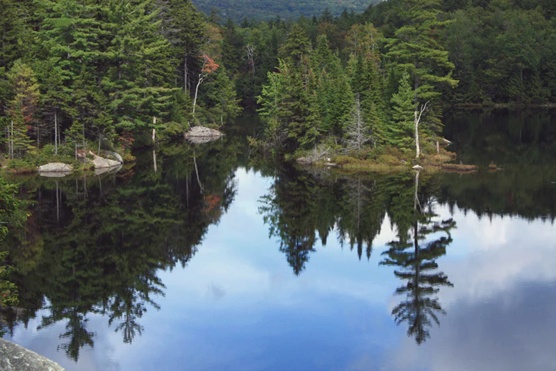
A calm, reflective pond surrounded by a dense evergreen forest, with the trees clearly mirrored in the still water.
Little Rock Pond reflects the surrounding coniferous forest in the Robert T. Stafford White Rocks National Recreation Area.

Robert T. Stafford White Rocks National Recreation Area history and protected-area timeline

The White Rocks National Recreation Area was established on June 19, 1984, through the Vermont Wilderness Act of 1984. This legislation created both the recreation area and several wilderness components within Vermont's national forests, reflecting a period of expanded federal recognition of Vermont's wild landscapes.

In 2006, the recreation area was renamed in honor of Robert T. Stafford, a prominent Vermont political figure who served as Governor of Vermont and later as a United States Representative and U.S. Senator. President George W. Bush signed the renaming legislation on January 17, 2006, giving the area its current designation as the Robert T. Stafford White Rocks National Recreation Area.

The renaming linked the recreation area to Stafford's broader legacy of public service and conservation advocacy in Vermont. While the underlying landscape and Forest Service management framework remained unchanged, the new name cemented a closer association between the protected land and the state's political and environmental heritage.

Robert T. Stafford White Rocks National Recreation Area landscape and geographic character

The landscape of White Rocks is shaped by the southern Green Mountains, where rolling forested ridges are interrupted by unusually rugged rock features. Most distinctive are the quartzite formations that give the area its name. Quartzite is an extremely hard metamorphic rock, and where it has fractured or broken loose over geologic time, it has left behind dramatic boulder fields, cliff faces, and rocky clefts that stand out sharply against the softer forest surroundings.

Chaos Canyon is the most celebrated example. It is a deep cleft running through a giant quartzite rockslide, and it conveys the sense of a landscape broken open by geological force. Around it the terrain shifts between steep rocky slopes, forested hollows, and broader ridge lines that eventually connect to wider Green Mountain uplands. The combination of rocky exposures and continuous forest cover gives the area a varied visual texture, especially in late autumn when leaf color contrasts with bare stone.

The area's elevation profile falls within the moderate range typical of southern Vermont, but the local relief feels sharper because of the quartzite outcrops and the dissected ravines they create. Streams and small drainages weave through these rocky zones, and the resulting mix of forest, water, and exposed stone defines the recreation area's signature scenery.

Robert T. Stafford White Rocks National Recreation Area ecosystems, habitats, and plant life

Ecologically, White Rocks is embedded in the broader forest landscape of the Green Mountain National Forest. Its vegetation is dominated by northern hardwood communities typical of the region, with sugar maple, American beech, yellow birch, and various conifers forming the backbone of the forest cover. Mixed stands and transitional zones are common, especially on slopes where soil depth and rock exposure vary over short distances.

Because two designated wilderness areas lie entirely within its boundaries, large portions of White Rocks are managed to preserve ecological processes with minimal direct human intervention. This means tracts of old-growth-like forest character, undisturbed soils, and intact wildlife habitat remain part of the recreation area's ecological identity, even though the area as a whole supports active recreation.

The quartzite-dominated terrain also influences habitat patterns. Thin-soiled rocky slopes support vegetation communities adapted to harsh conditions, while sheltered valleys and stream corridors hold richer, more mesic forest types. Together these create a mosaic of microhabitats across the recreation area that contributes to its ecological diversity within the larger Green Mountain forest system.

Robert T. Stafford White Rocks National Recreation Area wildlife and species highlights

Wildlife in White Rocks reflects both the hardwood forest ecosystems of the southern Green Mountains and the protected condition of the wilderness areas within its boundaries. White-tailed deer, black bear, and moose are part of the regional mammal community that inhabits the forest mosaic here, alongside smaller mammals such as red and gray fox, fisher, and various squirrel and chipmunk species common to Vermont's mature hardwood forests.

Birdlife is also characteristic of New England's mixed hardwood and northern forest environments. Forest-interior songbirds thrive in the quieter wilderness tracts, while species associated with edge habitat and openings can be found where forest cover transitions into rocky clearings or stream corridors. The combination of extensive forest cover and protected wilderness zones makes the area valuable for species sensitive to human disturbance.

The snowmobile trail network and Appalachian Trail corridor also play an indirect role in wildlife observation. While these uses bring human presence, the surrounding forest matrix and wilderness areas continue to support the animal populations typical of the central and southern Green Mountains, including raptors and migratory songbirds that rely on large, unbroken forest blocks for breeding habitat.

Robert T. Stafford White Rocks National Recreation Area conservation status and protection priorities

The conservation significance of White Rocks lies in the unusually layered protection it carries. As a National Recreation Area, the land is preserved under federal management for both ecological values and public enjoyment, while the inclusion of two congressionally designated wilderness areas, Peru Peak Wilderness and Big Branch Wilderness, adds a stricter level of protection across significant portions of the recreation area's footprint.

This nested design is ecologically meaningful because it ensures that even within a recreation-focused landscape, there are zones where motorized access is prohibited and natural processes take precedence. The wilderness components protect forest interior conditions, watershed integrity, and habitat continuity for species sensitive to human disturbance.

The presence of extensive forest cover, intact watersheds, and rugged quartzite terrain also supports long-term ecological resilience. By shielding large connected blocks of Green Mountain forest from fragmentation, White Rocks contributes to the broader conservation framework of the Green Mountain National Forest and to Vermont's larger network of protected public land.

Robert T. Stafford White Rocks National Recreation Area cultural meaning and human context

White Rocks carries a clear cultural dimension connected to Vermont's political and conservation history. Its current name honors Robert T. Stafford, whose career as Governor of Vermont, U.S. Representative, and U.S. Senator linked him to a generation of New England leaders associated with environmental protection and public land stewardship.

The recreation area also sits within the broader cultural landscape of southern Vermont, where small towns, forest-based livelihoods, and outdoor traditions shape the way public lands are used and valued. Long-distance hiking culture, represented by the Appalachian Trail, and winter recreation traditions, represented by the snowmobile trail network, both contribute to the area's identity as a place where conservation and active outdoor heritage coexist.

Top sights and standout views in Robert T. Stafford White Rocks National Recreation Area

The most distinctive highlights include the Chaos Canyon quartzite cleft, the 30-mile Appalachian Trail corridor, and the unusual combination of a National Recreation Area containing two designated wildernesses. The 61-mile snowmobile trail network also stands out as a defining winter feature, supporting one of Vermont's signature recreational traditions within a federally protected landscape.

Best time to visit Robert T. Stafford White Rocks National Recreation Area

White Rocks is a four-season landscape. Late spring and early summer bring lush forest cover and active hiking conditions, while autumn is particularly striking as the northern hardwood canopy turns color against the pale quartzite outcrops. Winter transforms the area into a hub for snowmobiling on the maintained trail network, and the colder seasons also offer quieter hiking and a clearer sense of the area's geological drama when leaves are down and rocky features are exposed. Wilderness zones within the recreation area reward quieter shoulder-season visits when solitude is most achievable.

Monthly climate preview

Long-term temperature and precipitation normals for Robert T. Stafford White Rocks National Recreation Area

Robert T. Stafford White Rocks National Recreation Area Climate and Weather by Month

Representative coordinate records show measured monthly temperature swings from sub-zero winter lows to warm summer maximums alongside steady daily precipitation amounts. Detailed twelve-month climate normals provide complete analytical depth for comparing long-term meteorological patterns.
Annual mean6 °C
-8 °C20 °C
Jan-8°
Feb-7°
Mar-2°
Apr
May12°
Jun17°
Jul20°
Aug19°
Sep15°
Oct
Nov
Dec-4°
Warmest month
July

19.7 °C

Coolest month
January

-8.2 °C

Wettest month
June

3.7 mm/day

Driest month
February

2.3 mm/day

Park location guide

Geography guide, regional context, and park location map for Robert T. Stafford White Rocks National Recreation Area

Robert T. Stafford White Rocks National Recreation Area park geography, regions, and map view in United States of America

Understand where Robert T. Stafford White Rocks National Recreation Area sits in United States of America through a broader geographic reading of the surrounding landscape, nearby location context, and its mapped position within the national park landscape.

How Robert T. Stafford White Rocks National Recreation Area fits into United States of America

The United States of America is a federal presidential republic and one of the world's largest countries by area and population. It consists of 50 states across a vast territory spanning multiple time zones, with its capital in Washington, D.C. and largest city in New York City. The nation has a diverse economy, influential political system, and significant cultural and military presence globally.

Wider geography shaping Robert T. Stafford White Rocks National Recreation Area in United States of America

The United States occupies a vast territory in North America, bordered by Canada to the north and Mexico to the south. The 48 contiguous states stretch from the Atlantic to the Pacific Ocean, while Alaska occupies the northwestern region and Hawaii is an archipelago in the Pacific. The country encompasses diverse terrain including the Rocky Mountains, Appalachian Mountains, Great Plains, and extensive river systems.

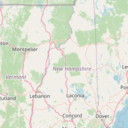
Map view of Robert T. Stafford White Rocks National Recreation Area

Use this park location map to pinpoint Robert T. Stafford White Rocks National Recreation Area in United States of America, understand its exact geographic position, and read its mapped placement within the surrounding landscape more clearly.

Pigeon | © OpenStreetMap contributors

Location context for Robert T. Stafford White Rocks National Recreation Area

Vermont

Visual exploration of quartzite formations, rugged terrain, and protected upland habitats

Robert T. Stafford White Rocks National Recreation Area Photos and Scenery

Visual records illustrate the rugged quartzite rock formations and continuous hardwood forests defining Robert T. Stafford White Rocks National Recreation Area. Protected area imagery reveals the stark geological contrast of Chaos Canyon and the surrounding southern Green Mountain terrain.

A calm, reflective pond surrounded by a dense evergreen forest, with the trees clearly mirrored in the still water.

Park atlas

Compare adjacent protected landscapes and surrounding regional mountain terrain.

Explore Parks Near Robert T. Stafford White Rocks National Recreation Area

Browse protected areas and national parks located near Robert T. Stafford White Rocks National Recreation Area. Compare surrounding southern Green Mountain terrain and discover related conservation lands across the region.
Watercolor painting of a lush green landscape featuring rolling hills in the distance, a meandering stream in the midground, and wetlands with cattails in the foreground.
Protected landscapeVermont
Mapped location lies within the park boundary#1 closest

North

Green Mountain National Forest: Mapped Geography and Protected Landscape Analysis

Examining the wilderness backbone of Vermont's mountainous terrain

Gain insight into the expansive boundaries of Green Mountain National Forest, an essential protected area spanning the Green Mountains of Vermont. This profile details the forest's composition, ranging from high-elevation spruce-fir zones to mixed hardwood slopes and extensive federal wilderness corridors, providing a foundational geographic understanding of this vital northeastern landscape.

Area
1,615.31 km²
Established
1932
Relief
Mountain
Climate
Temperate
A horizontal watercolor painting depicting a winding river flowing through a lush, forested valley with rolling hills in the background.
Wildlife reserveVermont
About 25 km away#2 closest

South

Lye Brook Wilderness: Protected High Plateau and Forest Geography in Southern Vermont

Mapped wilderness boundaries within the Green Mountain National Forest

Spanning nearly 18,000 acres, Lye Brook Wilderness offers a deep dive into southern Vermont's natural geography. The area features a high forested plateau, complex brook valleys, and elevated ridgelines that characterize this established wilderness reserve. Ideal for those studying the regional landscape and its protected ecosystem, this record provides essential context on the forest cover, glacial terrain, and the geographic significance of this Vermont backcountry unit.

Area
73.34 km²
Established
1975
IUCN
Ib
Wildlife reserveBennington County
About 55 km away#3 closest

South

George D. Aiken Wilderness: Protected Forest Landscapes and Ridgelines in Vermont

Detailed geographic overview of a Green Mountain wilderness reserve

Spanning over 4,800 acres in Bennington County, the George D. Aiken Wilderness stands as a significant protected area within the southern Green Mountains. The terrain features narrow ridgelines, steep valleys, and a dense canopy of northern hardwoods that remain unmanaged to maintain wilderness standards. This area serves as a primary geographic anchor for Eastern wilderness preservation efforts in the United States.

Area
19 km²
Established
1984
IUCN
Ib
Relief
Mountain
Protected areaAddison County
About 58 km away#4 closest

North

Joseph Battell Wilderness: Mapping Protected Ridges in the Green Mountain National Forest

A high-elevation Appalachian landscape in Addison County, Vermont.

Spanning over twelve thousand acres, the Joseph Battell Wilderness preserves a critical core of the Green Mountains. This protected area features dramatic cliff faces like Mount Horrid and a continuous sequence of summits exceeding three thousand feet. The region provides a deep look at northern hardwood habitats and the geographic influence of the Long Trail within the broader Vermont mountain landscape.

Area
49.92 km²
Established
2006
Relief
Mountain
Climate
Temperate
Protected landscapeNew Hampshire
About 80 km away#5 closest

Northeast

White Mountain National Forest: Protected Landscape Atlas and Geographic Boundary Context

Mapping the alpine ridges and river valleys of New Hampshire

Delve into the geography of White Mountain National Forest, a primary federal protected landscape in the eastern United States. This overview details the mountainous terrain, including the Presidential Range and Pemigewasset Wilderness, providing a clear window into its spatial scale, watershed boundaries, and regional prominence within the New England landscape.

Area
3,038.59 km²
Established
1918
Relief
Mountain
Climate
Temperate
A horizontal watercolor painting showing a wide coastal estuary with gentle hills in the background, a winding body of water in the middle ground, and soft green trees and shrubs in the foreground.
Nature reserveNew Hampshire
About 168 km away#6 closest

East

Great Bay National Estuarine Research Reserve: Protected Coastal and Estuarine Geography

Regional tidal habitat and protected watershed in New Hampshire

Great Bay National Estuarine Research Reserve protects a vital coastal landscape characterized by broad tidal basins, fringing salt marshes, and inland woodlands. Located in southeastern New Hampshire, this nature reserve serves as an essential site for studying the intersection of freshwater and saltwater ecosystems, preserving a mosaic of land and water that illustrates the complex geography of the Atlantic coast.

Area
41.42 km²
Established
1989
Relief
Lowland
Climate
Temperate
A watercolor painting of a green, rolling coastal landscape with gentle hills and trees under a white background.
Protected landscapeMassachusetts
About 200 km away#7 closest

Southeast

Boston Harbor Islands National and State Park: Mapping Coastal Protected Landscapes

A diverse archipelago of islands and tidal harbors in Massachusetts

Boston Harbor Islands National and State Park offers an expansive look at coastal geography within the Massachusetts Bay. Spanning dozens of islands and peninsulas, this protected landscape captures a blend of drumlin terrain, tidal salt marshes, and historic maritime structures set directly against the urban skyline of Boston.

Area
6 km²
Established
1996
Visitors
28.2K annual
Relief
Lowland
A soft watercolor painting depicting a wide, marshy wetland scene with gentle green hills in the distance and reflections on the water surface.
Wildlife reserveQuebec
About 222 km away#8 closest

Northwest

Réserve nationale de faune du lac-Saint-François: A Protected Wetland Landscape in Quebec

Explore wildlife reserve boundaries, riparian habitats, and St. Lawrence River geography.

This protected area safeguards a diverse freshwater wetland complex along the St. Lawrence River. Covering marshes, cedar stands, and mixed hardwood forests, the reserve provides a critical sanctuary for migratory species. The geography of the site offers a unique look at transition zones between open water and inland plains, serving as a key node for bird conservation in Quebec.

Area
15.21 km²
Established
1978
IUCN
III
Relief
Lowland

Common questions about visiting, size, designation, and location context for Robert T. Stafford White Rocks National Recreation Area

Robert T. Stafford White Rocks National Recreation Area FAQs for park facts, access, geography, and protected area context

Find quick answers about Robert T. Stafford White Rocks National Recreation Area, including protected-area facts, park geography, trail and visitor context, and how the park fits into its surrounding country and regional landscape.
MoriAtlas Explorer

Continue Your Protected Areas Search Across the Global Atlas

Deepen your exploration by continuing the structured search for national parks and protected areas worldwide. Utilize the comprehensive filtering capabilities to compare different conservation landscapes and refine your understanding of global park geography. Discover more about the distribution and characteristics of protected natural areas.

Global natural geography