
Waterfalls
Park geography
A structured examination of topography, elevation spans, and alpine landscape features.
Rocky Mountain National Park: Geographic Profile, Boundary Map, and Terrain Analysis
Examine the physical geography of Rocky Mountain National Park in Colorado through its recorded boundary data, elevation range, and diverse natural terrain. This profile details the park landscape, ranging from alpine peaks and mountain valleys to forest and wetland habitats within its 1074 square kilometer span.
Related tags
Alpine TundraMountain RangesGlacial LakesElk WildlifeContinental Divide
Alpine wilderness spanning Colorado's Continental Divide
Rocky Mountain National Park
Rocky Mountain National Park is a premier protected wilderness area in north-central Colorado, established in 1915 and encompassing over 265,000 acres of dramatic alpine terrain within the Front Range of the Rocky Mountains. The park straddles the Continental Divide, creating a unique geographic split where waters flow westward to the Pacific Ocean and eastward to the Atlantic. Visitors encounter a landscape of towering peaks exceeding 14,000 feet, glacially carved valleys, pristine alpine lakes, and diverse ecosystems that transition from montane forests through subalpine zones to exposed tundra. The park ranks among the most visited in the National Park System, drawing millions annually who come to experience its backcountry recreation, scenic drives, and wildlife viewing opportunities.
- Location
- United States of America
- Park type
- National park
- Established
- 1915
- Area
- 1,074.3 km²
- Highest point
- 4,346 m
Location overview
Regional and country-level positioning within the United States
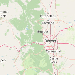
Geographic Location of Rocky Mountain National Park in Colorado
Rocky Mountain National Park is situated within the state of Colorado in the United States of America. Atlas entries clarify the regional boundaries and country-level administrative relationships of the protected area.
- Countries
- United States of America
- Regions
- Colorado
- Primary location
- Colorado
Boundary and coordinates
Rocky Mountain National Park’s outline spans 1,074.28 km²
Rocky Mountain National Park mapped boundary and 1,074.28 km² area
Rocky Mountain National Park has mapped geometry for its documented 1,074.28 km² extent. The broad outline gives the park spatial context, with no separate component-area allocation or perimeter recorded.
- Boundary area
- 1,080.1 km²
- Boundary perimeter
- 227.5 km
- Northernmost point
- 40.5538° N
- Southernmost point
- 40.1578° N
- Easternmost point
- 105.4936° W
- Westernmost point
- 105.9137° W
- Geographic centre
- 40.3555° N, 105.6973° W
- North–south span
- 44 km
- East–west span
- 35.7 km
Elevation and terrain
Mountain relief statistics and recorded natural features
Rocky Mountain National Park Terrain and Elevation Range Geography
Recorded elevation ranges span from 2396 meters to 4346 meters across the mountain terrain. Linked feature cards provide names, types, measurements, and spatial relationships where recorded.
- Minimum elevation
- 2,396 m
- Maximum elevation
- 4,346 m
- Highest point
- 4,346 m
Selected named natural features
Waterfalls
Lyric Falls
Waterfalls
Thousand Falls
Lakes
Shelf Lake
Rivers
Big Thompson River
Ridges
Blitzen Ridge
Environmental setting
Alpine climate zones, forest cover, and terrain classifications
Rocky Mountain National Park Environmental Settings and Landscape Classifications
Stored landscape features, habitat types, and relief classifications frame the physical setting of Rocky Mountain National Park. Recorded categories connect directly to related atlas destinations for structured geographic navigation.
- Relief
- Mountain
- Climate
- Alpine
- Water
- Major water bodies
- Forest cover
- Mostly forested
- Seasonality
- Strongly seasonal
Landscape features
Mountains · Valleys · Canyon · Forest · Grassland · Wetland · Lakes · Rivers · Glacier · Tundra · Cliffs
Habitat types
Temperate coniferous forest · Boreal forest · Alpine meadow · Grassland · Shrubland · Wetland · Riverine habitat · Lacustrine habitat · Tundra habitat · Glacial habitat
Park atlas
Compare alpine landscapes and diverse ecosystems across the Front Range, tracing connected protected areas in the region.
Explore Nearby National Parks and Protected Areas: A Geographic Companion to Rocky Mountain National Park
After exploring Rocky Mountain National Park, browse other national parks and protected areas showcasing similar alpine tundra, mountain ranges, and subalpine forests across the surrounding Rocky Mountain region. Compare diverse conservation landscapes, map regional park geography, and trace the spread of protected wilderness areas to understand their connected environmental contexts.
Protected landscapeGrand County
Park boundaries overlap#1 closest
South

Arapaho National Recreation Area: Geographic Profile and Protected Landscape Context
High-country mountain reservoirs and forested mountain terrain
The Arapaho National Recreation Area defines a unique intersection of montane forest and water-based geography in Grand County, Colorado. As the home to the Great Lakes of Colorado, this protected landscape provides a critical connection point between the Colorado River headwaters and the Continental Divide. Examine the park's terrain, reservoir distribution, and its role as a forested gateway to the neighboring mountain regions.
- Area
- 124.2 km²
- Established
- 1978
- Relief
- Mountain
- Climate
- Alpine
Wildlife reserveColorado
Park boundaries overlap#2 closest
Southeast
Indian Peaks Wilderness: Alpine Geography and Front Range Protected Landscapes
Mapping high country summits and glacial basins in Colorado
Indian Peaks Wilderness stands as a signature wildlife reserve along the Colorado Continental Divide. This atlas entry focuses on its complex system of thirteen-thousand-foot peaks, relict glaciers, and interconnected alpine lakes that define the Front Range. Gain insight into the protected boundaries and glacial geomorphology that characterize this high-country landscape near the Denver metropolitan region.
- Area
- 310.44 km²
- Established
- 1978
- IUCN
- Ib
- Relief
- Mountain
Wildlife reserveColorado
Park boundaries overlap#3 closest
West
Never Summer Wilderness: Protected Mountain Geography and Alpine Terrain in Colorado
High-altitude wilderness along the Continental Divide
Spanning over 21,000 acres, the Never Summer Wilderness defines a critical segment of the Colorado Rockies. This protected area features a jagged skyline of 12,000-foot summits, extensive alpine tundra, and the remarkable old-growth spruce and fir forests of Bowen Gulch. Use these maps to understand its role as a vital headwater landscape and its position as a sanctuary for alpine wildlife and ecosystems.
- Area
- 85.3 km²
- Established
- 1980
- IUCN
- Ib
- Relief
- Mountain
Protected landscapeColorado
Park boundaries overlap#4 closest
North
Roosevelt National Forest: Mapping Wilderness and Protected Landscapes in Northern Colorado
Regional geography, river corridors, and alpine mountain terrain
Roosevelt National Forest encompasses a significant protected landscape across Larimer, Boulder, Gilpin, and Jefferson counties. The forest features a complex terrain of deep canyons, forested plateaus, and protected wilderness areas that form a scenic buffer along the eastern side of the Continental Divide and Rocky Mountain National Park.
- Area
- 3,293.33 km²
- Established
- 1902
- Relief
- Mountain
- Climate
- Subpolar
Wildlife reserveColorado
About 34 km away#5 closest
South
James Peak Wilderness: Geographic Profile and Protected Landscape Mapping
High elevation terrain in the Colorado Rockies
James Peak Wilderness provides a critical protected landscape featuring dramatic alpine summits, U-shaped glacial valleys, and subalpine meadows. Its geographic structure forms an essential ecological link along the Colorado Front Range, characterized by high-elevation peaks, dense coniferous forests, and diverse tundra ecosystems situated immediately east of the Continental Divide.
- Area
- 68.86 km²
- Established
- 2002
- IUCN
- Ib
Wildlife reserveColorado
53 km away#6 closest
Southwest
Eagles Nest Wilderness: Alpine Geography and Protected Landscape of the Colorado Gore Range
High-mountain protected area in the White River National Forest
Spanning the southern Gore Range, Eagles Nest Wilderness represents a core protected landscape in Colorado characterized by high-elevation peaks, glacial cirque lakes, and extensive backcountry trail networks. Its geography bridges the gap between deep coniferous forests and exposed alpine tundra, maintaining significant ecological and historical value within the mountainous terrain of Eagle and Summit Counties.
- Area
- 546.79 km²
- Established
- 1976
- IUCN
- Ib
- Relief
- Mountain

Protected areaColorado
54 km away#7 closest
South
Mount Evans Wilderness: Alpine Landscapes and Protected Geography in Colorado
Glacial cirques and high-altitude wilderness ecosystems.
Mount Evans Wilderness offers a premier look at the Colorado Front Range, defined by its dramatic relief, sheer cliff lines, and extensive glacial history. This entry examines the wilderness as a protected zone that transitions from montane forests to tundra, providing a reference for high-elevation mountainous geography within the United States.
- Area
- 301.09 km²
- Established
- 1980
- IUCN
- Ib
- Relief
- Mountain
Protected areaColorado
60 km away#8 closest
South
Pike National Forest: Protected Mountain Landscapes and Regional Geography in Central Colorado
Granite peaks, montane forests, and diverse alpine terrain
Spanning from the rolling foothills of the Front Range to the high alpine summits of the Rocky Mountains, Pike National Forest is a significant protected area defined by its unique Pikes Peak granite bedrock and deep river-carved canyons. This analysis provides a structured look at its expansive wilderness boundaries, drainage basins, and the vertical transitions that characterize this vital central Colorado highland.
- Area
- 4,478.27 km²
- Established
- 1892
- Relief
- Mountain
- Climate
- Alpine
MoriAtlas Explorer
Continue Exploring Rocky Mountain National Park's Geographic and Landscape Context
Deepen your understanding of Rocky Mountain National Park's protected landscape identity and its place within Colorado's broader geography. This resource provides essential context for exploring national park boundaries and natural terrain, offering a factual atlas perspective to inform your discovery of conservation areas and mapped natural features.
Browse next
Global natural geography
Explore related park routes
Explore MoriAtlas Global ParksBrowse All MoriAtlas ParksGlobal Park Map DiscoveryMoriAtlas: Browse All CountriesBrowse All MoriAtlas ContinentsNational Park Environment AtlasGrand Canyon National Park AtlasYellowstone National Park AtlasYosemite National Park Atlas and GeographySerengeti National Park AtlasGalápagos National Park Protected LandscapeBanff National Park Geography and AtlasKruger National Park Atlas EntryUluṟu-Kata Tjuṯa National Park AtlasExplore Uluru-Kata Tjuta National Park GeographyPlitvice Lakes National Park AtlasFiordland National Park Protected LandscapeGreat Smoky Mountains National Park AtlasAfghanistan National Parks and Protected AreasAlbania National Parks and Protected AreasAlgeria National Parks and Protected AreasAmerican Samoa National Parks and Protected AreasAndorra National Parks and Protected AreasAngola National Parks and Protected AreasAntarctica National Parks and Protected AreasAntigua and Barbuda Park List