Mori Atlas logo
Protected areaRongerik Atoll

A remote Pacific coral landscape featuring expansive lagoon systems and unique reef boundaries.

Rongerik Atoll Protected Area and Coral Atoll Geography in the Marshall Islands

Rongerik Atoll stands as a classic low-lying coral system in the Ralik Chain of the Marshall Islands, defined by its stark contrast between a vast 144 square kilometer central lagoon and a narrow rim of islets. This protected area offers a deep look into the regional geography of Micronesia, where isolated landmasses interact with deep Pacific waters. By tracing its mapped boundaries, observers gain insight into the structural composition of small-scale atoll ecosystems and their role within the broader Pacific maritime territory.

coral atolluninhabited islandPacific OceanMarshall IslandsRalik Chainremote atoll

Rongerik Atoll

Protected area

Park overview

Structured park overview, official facts, and landscape profile for Rongerik Atoll

Rongerik Atoll park facts, protected area profile, and essential visitor context

Review the core facts for Rongerik Atoll, including designation, size, terrain, visitor scale, habitats, and operating context in one park-focused overview.

About Rongerik Atoll

Rongerik Atoll occupies a secluded position in the Ralik Chain, the western island chain of the Marshall Islands in the central Pacific Ocean. Although its total land area is only about 1.68 square kilometers, distributed across roughly 17 to 22 small islets (sources vary slightly), the atoll surrounds a lagoon of about 144 square kilometers, giving it the characteristic form of a Pacific coral ring enclosing a broad interior sea. Because the atoll is entirely uninhabited and lies far from major shipping routes, it preserves a relatively undisturbed coral island environment typical of the wider Marshall Islands archipelago.

The atoll is uninhabited today, but it was briefly home to a community between 1946 and 1948 when the indigenous inhabitants of Bikini Atoll were relocated there while the United States prepared Bikini for the Operation Crossroads nuclear tests. This short-lived resettlement left a deep mark on Rongerik's modern identity, because the experience of displacement, food shortages, and eventual relocation to Kili Island became part of the broader story of the Marshallese people and the nuclear age in the Pacific.

Rongerik also sits within the wider geopolitical history of Micronesia. It was claimed by the German Empire in 1885, passed to the Japanese South Seas Mandate after the First World War, came under United States military administration during and after the Second World War, and later formed part of the Trust Territory of the Pacific Islands. It became part of the independent Republic of the Marshall Islands in 1986, which maintains a close association with the United States. The atoll therefore represents both a remote natural setting and a key location in the layered colonial and Cold War history of the region.

Quick facts and research context for Rongerik Atoll

Rongerik Atoll is an uninhabited coral atoll in the Ralik Chain of the Marshall Islands, located about 200 kilometers east of Bikini Atoll in the North Pacific. Its total land area is roughly 1.68 square kilometers spread across about 17 to 22 small islets, although the enclosed lagoon covers around 144 square kilometers. Administratively the atoll belongs to the Republic of the Marshall Islands, an independent nation founded in 1986 and linked to the United States through a Compact of Free Association.

Protection and recognition

Examine documented protection scope and international recognition details

Rongerik Atoll Protection Status and Designated Conservation Context

Rongerik Atoll maintains a mixed protection scope outlining its formal conservation framework and territorial boundaries. Structured records supply verified designation facts for analyzing international recognition status across the protected landscape.

Protection details

Protection scope
Mixed
Transboundary protection
No
Park context

Deeper park guide and search-rich context for Rongerik Atoll

Rongerik Atoll history, landscape, wildlife, and travel context

Explore Rongerik Atoll through its history, landscape character, ecosystems, wildlife, conservation priorities, cultural context, and seasonal travel timing in a structured park guide built for atlas discovery and search intent.

Why Rongerik Atoll stands out

Rongerik is best known as the temporary home of the Bikini Atoll community during the United States' 1946 Operation Crossroads nuclear tests, and as a Pacific atoll affected by radioactive fallout from the 1954 Castle Bravo test. Beyond its postwar history, it is also recognized as a classic example of a small, low-lying, uninhabited Marshallese coral atoll with a vast lagoon in relation to its land area.
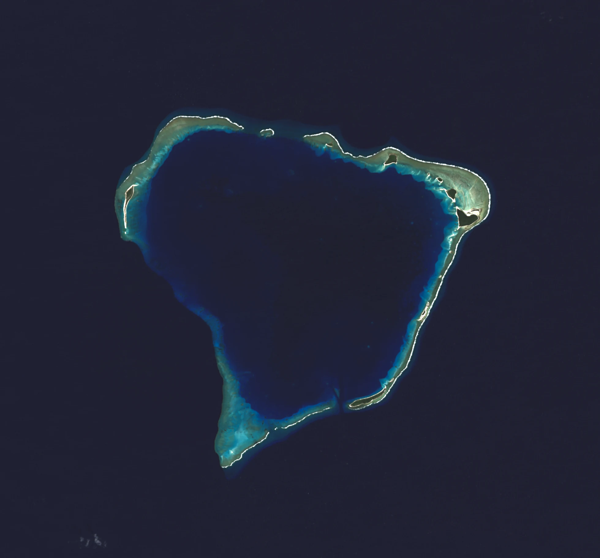
Top-down satellite view of a coral atoll featuring a central deep blue lagoon surrounded by a ring of small sandy islets and coral reef structures against a dark ocean background.
A satellite view of Rongerik Atoll in the Marshall Islands.

Rongerik Atoll history and protected-area timeline

Rongerik Atoll was claimed by the German Empire in 1885 along with the wider Marshall Islands, and after the First World War it came under the South Seas Mandate administered by the Empire of Japan. Throughout much of this period the atoll itself appears to have remained uninhabited, even as colonial control shifted between powers.

During and after the Second World War, Rongerik became part of the extensive United States Naval Base Marshall Islands. Following the end of the war it was administered as part of the Trust Territory of the Pacific Islands under United Nations oversight, until the Marshall Islands achieved independence in 1986 and emerged as a sovereign nation with a Compact of Free Association with the United States.

The atoll's most prominent historical chapter began in March 1946, when the indigenous population of Bikini Atoll was relocated to Rongerik so that the United States could use Bikini for the Operation Crossroads nuclear tests. Despite their cooperation with the US Navy, the relocated communities could not secure enough food on Rongerik, and after roughly two years of shortages and malnutrition they were moved first to Kwajalein and ultimately to Kili Island, where many of their descendants still live. On March 1, 1954, Rongerik itself was exposed to radioactive fallout from the Castle Bravo thermonuclear test, part of Operation Castle, adding an environmental layer to its already complex postwar history.

Rongerik Atoll landscape and geographic character

Rongerik is a low coral atoll of the classic Pacific type, where a thin ring of small islands traces the edge of a much larger central lagoon. The combined land area of the islets is only about 1.68 square kilometers, but the enclosed lagoon reaches roughly 144 square kilometers, producing a striking contrast between the narrow land rim and the broad interior sea.

The atoll sits in the North Pacific, around 200 kilometers east of Bikini Atoll, and its islands rise only a few meters above sea level. Like other Marshallese atolls, its terrain consists of sandy and coral rubble islets, likely backed by sparse vegetation, and surrounded by reef flats and deeper ocean waters. The relative proportions of land and lagoon make Rongerik a textbook example of an open-ocean coral atoll, where the visible landmass is only a small fraction of the total atoll structure.

Rongerik Atoll ecosystems, habitats, and plant life

The ecological character of Rongerik reflects its position as a remote, low-lying coral atoll. It supports typical Marshallese reef and lagoon habitats, including coral reef communities along the outer edge, sandy and rubble islets with limited terrestrial vegetation, and the sheltered lagoon environment within. Because the atoll has long been uninhabited and is remote from large populations, its reef and island ecosystems remain part of the broader network of relatively undisturbed Micronesian atoll environments.

Atolls of this kind function as important nodes in Pacific marine biodiversity, connecting reef, lagoon, pelagic, and seabird habitats in a single small system. Rongerik's specific vegetation and ecological details are not extensively documented in available sources, but its setting places it firmly within the tropical marine and coral island ecology that defines the Marshall Islands.

Rongerik Atoll wildlife and species highlights

Detailed information on the specific fauna of Rongerik Atoll is limited, but as a remote Pacific coral atoll it would be expected to support the typical range of Marshallese reef and seabird life associated with similar uninhabited atolls. Its reef, lagoon, and open-ocean environments provide habitat for reef fish, pelagic species, and seabirds that use the small islets for roosting and nesting.

Rongerik Atoll conservation status and protection priorities

Rongerik's conservation significance is shaped by two overlapping factors. As an uninhabited atoll with limited human pressure, its reef and island environments are part of the broader network of relatively intact coral atoll systems in the Marshall Islands. At the same time, its exposure to radioactive fallout from the 1954 Castle Bravo test, in addition to its role as a temporary relocation site for the Bikini community during Operation Crossroads, makes it a focus of attention within the wider legacy of nuclear testing in the Pacific.

Although the atoll is not described in detail as a formal protected area in available sources, its low population pressure and limited development contribute to its undisturbed character, and its ecological and historical value has been recognized in regional and international discussions about the environmental legacy of nuclear testing in Micronesia.

Rongerik Atoll cultural meaning and human context

Rongerik's modern cultural significance is closely tied to the experience of the Bikini Islanders, who were relocated there from 1946 to 1948 during the United States' postwar nuclear testing program. Although the Marshallese had no prior permanent presence on the atoll, the brief and difficult resettlement left a strong imprint on the collective memory of the affected communities, many of whose descendants now live on Kili Island.

The atoll also occupies a niche in the wider Micronesian story of shifting colonial administration, having moved from German, to Japanese, to United States stewardship before becoming part of the independent Republic of the Marshall Islands. A Spanish researcher has argued that Rongerik and several other small Micronesian islands were never formally transferred from Spain to Germany and remain nominally under Spanish sovereignty, although Spain reviewed the claim in 1949 and has not actively asserted it.

Top sights and standout views in Rongerik Atoll

Rongerik's profile is shaped by a combination of remoteness, size, and history. The atoll's very small land area of about 1.68 square kilometers sits in stark contrast to its 144 square kilometer lagoon, making it a textbook example of a Pacific coral atoll. Its location 200 kilometers east of Bikini Atoll places it within one of the most historically charged regions of Micronesia.

The atoll's standout associations are its role as the 1946 to 1948 relocation site for the people of Bikini Atoll during Operation Crossroads and its contamination by fallout from the Castle Bravo test of 1954. Together these events connect an otherwise quiet, uninhabited atoll to some of the defining episodes of the Pacific nuclear age.

Best time to visit Rongerik Atoll

Information about specific seasonal access, tourism infrastructure, or operational visit windows for Rongerik Atoll is not well supported by available sources, and the atoll is uninhabited with no documented visitor facilities. As an uninhabited Marshallese coral atoll, conditions would broadly follow typical tropical Pacific patterns of warm temperatures year round, with wetter and drier periods influencing reef conditions, sea state, and accessibility by boat. Visitors interested in the atoll's history and marine environment would generally seek calm, dry-season conditions typical of the region, but any visit would require independent logistical planning.
Monthly climate preview

Long term average temperature and monthly precipitation patterns across the atoll

Rongerik Atoll Climate Normals and Annual Weather by Month

Representative coordinate records show steady mean temperatures above twenty-six degrees Celsius alongside measurable monthly precipitation shifts throughout the year. Reviewing the complete twelve-month profile provides deeper analytical context for long-term meteorological trends across the protected atoll geography.
Annual mean28 °C
27 °C28 °C
Jan27°
Feb27°
Mar27°
Apr27°
May28°
Jun28°
Jul28°
Aug28°
Sep28°
Oct28°
Nov28°
Dec28°
Warmest month
October

28.1 °C

Coolest month
February

26.7 °C

Wettest month
October

5.3 mm/day

Driest month
February

0.8 mm/day

Park location guide

Geography guide, regional context, and park location map for Rongerik Atoll

Rongerik Atoll park geography, regions, and map view in Marshall Islands

Understand where Rongerik Atoll sits in Marshall Islands through a broader geographic reading of the surrounding landscape, nearby location context, and its mapped position within the national park landscape.

How Rongerik Atoll fits into Marshall Islands

The Marshall Islands is a sovereign island nation in Oceania, located in the Micronesia region of the Northwestern Pacific Ocean. The territory consists of 29 coral atolls and five main islands plus over 1,200 very small ones, divided across two island chains: Ratak in the east and Ralik in the west. The country gained independence from the United States in 1979 and maintains a Compact of Free Association with the US. It is notable for having the highest proportion of water to land of any sovereign state, at 98.62%.

Wider geography shaping Rongerik Atoll in Marshall Islands

The Marshall Islands is located in the Micronesia region of the Northwestern Pacific Ocean, west of the International Date Line and north of the equator. The territory is composed of 29 coral atolls and five main islands, plus approximately 1,220 very small islets, divided into two island chains: Ratak (eastern) and Ralik (western). Maritime boundaries are shared with Wake Island to the north, Kiribati to the southeast, Nauru to the south, and the Federated States of Micronesia to the west.

Map view of Rongerik Atoll

Use this park location map to pinpoint Rongerik Atoll in Marshall Islands, understand its exact geographic position, and read its mapped placement within the surrounding landscape more clearly.

Pigeon | © OpenStreetMap contributors

Explore visual records of low coral islets, expansive lagoons, and remote marine habitats.

Rongerik Atoll Photos and Scenery: Visualizing Remote Coral Landscapes

Visual records capture the striking contrast between narrow coral islets and the vast central lagoon of Rongerik Atoll. Examining these protected area views helps observers understand the austere terrain and remote maritime environment of this isolated Pacific location.

Top-down satellite view of a coral atoll featuring a central deep blue lagoon surrounded by a ring of small sandy islets and coral reef structures against a dark ocean background.

Park atlas

Compare remote coral atolls and connected marine ecosystems across the region

Explore Parks Near Rongerik Atoll and Surrounding Protected Island Landscapes

Browse protected areas near Rongerik Atoll to examine similar coral reef systems and remote island geography across the Pacific. Comparing these isolated marine landscapes provides deeper context on regional topography and protected habitats.
A minimalist watercolor painting featuring soft, light green hills in the foreground and faded, purple-toned mountains in the distant background, all set against a white backdrop.
Protected areaMarshall Islands
About 73 km away#1 closest

West

Rongelap Atoll Protected Area: Geography, Reef Structure, and Marshall Islands Context

Coral atoll terrain in the Pacific Ralik Chain

Located in the Ralik Chain of the Marshall Islands, Rongelap Atoll consists of 61 low-lying coral motus that enclose a lagoon covering 2,600 square kilometers. The atoll serves as a significant geographic study area, known for its distinct reef-built structure and its enduring role in Pacific history. This protected area continues to represent the ecological and cultural complexity of the Micronesian archipelago.

Area
21 km²
Relief
Lowland
Climate
Tropical
Access
Remote access
Protected areaMarshall Islands
About 123 km away#2 closest

West

Ailinginae Atoll Protected Area: Geographic Overview and Mapped Lagoon Systems

Remote coral atoll landscape in the Marshall Islands

Uncover the geographic structure of Ailinginae Atoll, an uninhabited coral ring in the Marshall Islands characterized by its expansive internal lagoon and narrow island segments. This protected area offers significant insight into the terrain of low-lying Pacific atoll ecosystems and their role within the Ralik Chain geographic framework.

Area
2.8 km²
Relief
Lowland
Water
Water-dominated
Watercolor painting of a landscape showing a body of water surrounded by green land with trees and distant hills, with soft pink and purple washes on the sides
Protected areaMarshall Islands
About 243 km away#3 closest

Southeast

Likiep Atoll: A Mapped Protected Area in the Marshall Islands Ratak Chain

Coral atoll geography and historical colonial landscape features

Likiep Atoll consists of 65 islands encircling a 424 square kilometer lagoon. As a protected area in the Marshall Islands, it offers insight into low lying atoll topography, unique marine environments, and the cultural remnants of successive colonial administrations.

Area
10.26 km²
Relief
Lowland
Climate
Tropical
Access
Remote access
A pale, soft watercolor illustration depicting distant islands or atoll ridges across a calm lagoon, with silhouetted palm trees in the foreground on the left and right.
Protected areaMarshall Islands
About 291 km away#4 closest

South

Kwajalein Atoll Protected Area and Marshall Islands Geographic Landscape Mapping

Pacific coral atoll structure and lagoon geography

Kwajalein Atoll represents a mature coral formation encompassing an immense lagoon within the Ralik Chain. The landscape consists of low-lying islets and interconnected reef structures that define the maritime geography of the Marshall Islands. This assessment provides a focus on the structural, mapped, and physical attributes that distinguish this protected site within the wider Pacific regional context.

Area
16.4 km²
Relief
Lowland
Climate
Tropical
Access
Highly restricted
Protected areaMarshall Islands
About 293 km away#5 closest

East

Ailuk Atoll Protected Area: Geography and Mapped Coral Landscapes in the Marshall Islands

Pacific atoll terrain, lagoon systems, and island geography

Study the geographic composition of Ailuk Atoll, featuring its classic ring of coral islets, deep-water reef passes, and vast central lagoon. This protected area offers insight into the subsidence-driven formation of Marshallese island chains and the enduring human reliance on traditional maritime navigation within a fragile Pacific ecosystem.

Area
5.4 km²
Relief
Lowland
Climate
Tropical
Access
Remote access
Protected areaMarshall Islands
About 309 km away#6 closest

East

Bikar Atoll Protected Area: Geographic Overview of a Remote Marshall Islands Coral Atoll

A pristine, uninhabited coral sanctuary and critical Pacific marine habitat.

Bikar Atoll is a remote, diamond-shaped coral ring located in the Ratak Chain of the Marshall Islands. Defined by its shallow lagoon, continuous reef structure, and arid islets, the atoll serves as a vital nesting site for seabirds and green turtles. This protected area remains one of the most ecologically undisturbed sites in the Pacific, offering rare insight into natural atoll morphology and island conservation.

Area
0.5 km²
Established
2025
Relief
Lowland
Climate
Tropical
Protected areaMarshall Islands
About 392 km away#7 closest

Northeast

Bokak Atoll Protected Area: Mapping the Northern Ratak Chain of the Marshall Islands

A remote coral atoll with a rare perched lagoon and pristine reef ecosystem

Bokak Atoll represents a primary example of an undisturbed central Pacific coral atoll, defined by its lack of introduced species and its striking perched lagoon. The landscape consists of low coral islets along a crescent reef, creating a specialized habitat for seabird colonies and stony coral reefs. This geographic overview examines the atoll's isolation and its status as a critical protected natural area within the wider Marshall Islands territory.

Area
129 km²
Relief
Lowland
Climate
Tropical
Access
Remote access
Protected areaMarshall Islands
About 636 km away#8 closest

South

Namdrik Atoll Protected Area: Geography and Coastal Ecosystems in the Marshall Islands

A remote Ramsar-recognized coral atoll and marine wetland.

Namdrik Atoll is a distinctive coral atoll within the Ralik Chain of the Marshall Islands, recognized for its exceptional mangrove forests and protected marine ecosystems. This area consists of two wooded islands enclosing a large lagoon without navigable passes, creating an isolated habitat for sea turtles and diverse reef life. Explore the geography of this small, ecologically significant protected land that represents the unique environmental character of the central Pacific.

Area
2.8 km²
Established
2012
Relief
Lowland
Climate
Tropical

Common questions about visiting, size, designation, and location context for Rongerik Atoll

Rongerik Atoll FAQs for park facts, access, geography, and protected area context

Find quick answers about Rongerik Atoll, including protected-area facts, park geography, trail and visitor context, and how the park fits into its surrounding country and regional landscape.
MoriAtlas Explorer

Continue Your Protected Areas Search Across the Global Atlas

Deepen your exploration by continuing the structured search for national parks and protected areas worldwide. Utilize the comprehensive filtering capabilities to compare different conservation landscapes and refine your understanding of global park geography. Discover more about the distribution and characteristics of protected natural areas.

Global natural geography