
Mori Atlas logo
Nature reserveRossert - Hainkopf - Dachsbau

Discover the forested ridge terrain and habitat conservation zones of this Taunus foothills nature reserve

Rossert - Hainkopf - Dachsbau Nature Reserve: Mapped Geography and Protected Landscapes of Hessen

(Naturschutzgebiet Rossert - Hainkopf - Dachsbau)

Rossert - Hainkopf - Dachsbau serves as a significant protected nature reserve within the Taunus foothills of Hessen, Germany. This mapped landscape encompasses a forested ridge system connecting the Rossert, Hainkopf, and Dachsbau summits. The area preserves essential low-mountain beech woodland, small meadow clearings, and the vital headwaters of the Wellbach stream, functioning as a crucial ecological link within the Natura 2000 network.

taunus foothillslow-mountain forestbeech woodlandnature reservenaturschutzgebiethabitat protection
A flat-design digital illustration of a green meadow bordered by diverse trees and a rocky outcrop under a pale sky.

Rossert - Hainkopf - Dachsbau

Nature reserve

Park overview

Structured park overview, official facts, and landscape profile for Rossert - Hainkopf - Dachsbau

Rossert - Hainkopf - Dachsbau park facts, protected area profile, and essential visitor context

Review the core facts for Rossert - Hainkopf - Dachsbau, including designation, size, terrain, visitor scale, habitats, and operating context in one park-focused overview.

About Rossert - Hainkopf - Dachsbau

Rossert - Hainkopf - Dachsbau is a designated nature reserve in the central Taunus region of Hessen, in west-central Germany. It sits on the ridge of the Rossert and extends across two named subsidiary summits, the Hainkopf at about 474 meters above sea level and the Dachsbau at about 373 meters above sea level. The protected area curves around the south side of Eppenhain, a village district of the town of Kelkheim (Taunus), forming a woodland belt that follows the natural contours of the hill ridge.

The site has been formally protected since 1977 as a Naturschutzgebiet under Hessen state conservation law and is internationally recognized through its inclusion in the World Database on Protected Areas. In 2020 the area was expanded from its original extent to roughly 126.4 hectares, strengthening the protection of the ridge and its connecting forest tracts. In slightly smaller form, about 118 hectares, it is also designated as an FFH area and forms part of the European Natura 2000 network, underlining its cross-border ecological significance.

The terrain is shaped by the gentle, rounded profile of the Taunus foothills, a low mountain range stretching north of the Main valley. The reserve covers forested slopes, ridge-top vegetation, and small grassy openings. On the Heimliche Wiese, a meadow southeast of the Rossert summit, the Wellbach stream originates; it flows downhill toward Eppstein and eventually joins the Schwarzbach, which leads into the Main. Forest roads, state roads (L 3011 to the west and L 3016 to the east), and the federal B 455 to the south frame the protected landscape.

Surrounding protected areas complement the reserve's ecological network. To the west lies the Dattenbachtal zwischen Kröftel und Vockenhausen nature reserve, and to the east lies the Krebsbachtal bei Ruppertshain, both of which conserve valley forests and streams that connect to the broader Taunus woodland mosaic. Together, these neighboring reserves create a network of forest and valley habitats in one of Germany's most heavily populated regions, where natural landscapes are otherwise fragmented by urban and suburban development around Frankfurt am Main.

Quick facts and research context for Rossert - Hainkopf - Dachsbau

Rossert - Hainkopf - Dachsbau is a designated Naturschutzgebiet (nature reserve) in the Main-Taunus-Kreis of Hessen, in central-western Germany. It has been protected since 1977 under the designation 1436001 and is listed internationally in the World Database on Protected Areas (WDPA ID 82443). The reserve is also a Natura 2000 FFH site (DE5816301), placing it within the European network of habitat-protected areas.

The reserve covers about 119 hectares of the Rossert ridge and its subsidiary summits Hainkopf and Dachsbau, south of Eppenhain, and was expanded to roughly 126.4 hectares in 2020. It lies in the foothills of the Taunus range, west of Frankfurt, and borders other protected valley ecosystems, including the Dattenbachtal and Krebsbachtal nature reserves.

Protection and recognition

Documented conservation recognition and official protected area designations

Rossert - Hainkopf - Dachsbau Protection Status and Natura 2000 Records

Rossert - Hainkopf - Dachsbau incorporates official Natura 2000 records within its documented protection framework. Conservation research relies on verified international recognition sources to catalog habitat boundaries and protected area designations.
Park context

Deeper park guide and search-rich context for Rossert - Hainkopf - Dachsbau

Rossert - Hainkopf - Dachsbau history, landscape, wildlife, and travel context

Explore Rossert - Hainkopf - Dachsbau through its history, landscape character, ecosystems, wildlife, conservation priorities, cultural context, and seasonal travel timing in a structured park guide built for atlas discovery and search intent.

Why Rossert - Hainkopf - Dachsbau stands out

Rossert - Hainkopf - Dachsbau is known primarily as a compact, ecologically protected section of the Taunus foothills, where the hilltop ridge of the Rossert and its side summits are covered in mixed forest. The site's natural significance lies in preserving a continuous woodland habitat that links into the broader forested landscape of the Taunus, while also protecting small-scale meadow and spring habitats along the ridge. The reserve is also recognized for its dual conservation status: as a long-standing German Naturschutzgebiet under IUCN Category IV (habitat and species management), and as part of the European Natura 2000 network through its FFH designation. This combined protection highlights the area's value for conserving low-mountain forest ecosystems and their associated habitat structure in a heavily populated region of Germany near the Frankfurt metropolitan area.
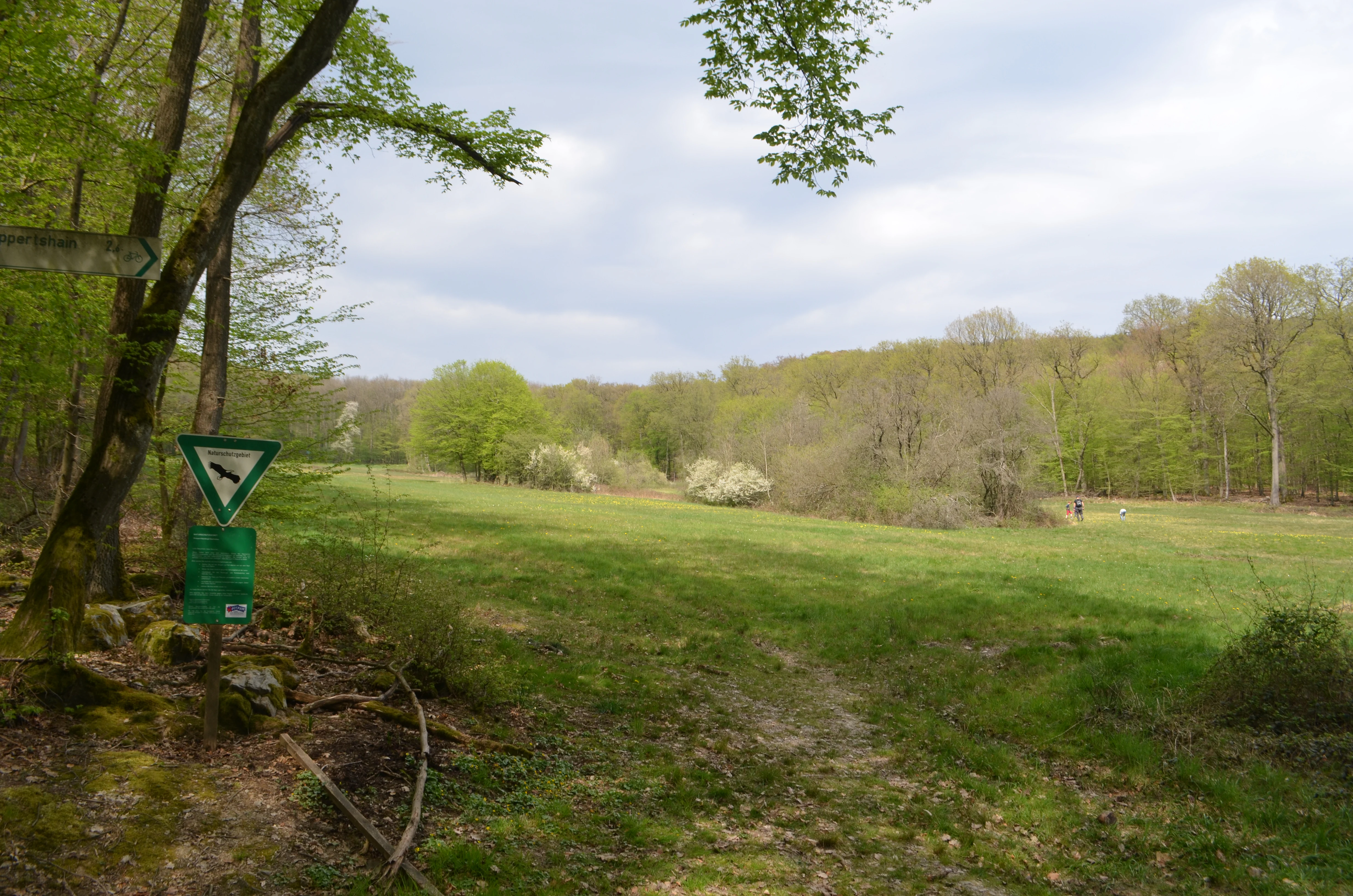
A meadow landscape with a walking path, surrounded by light green forest under a cloudy sky. A nature reserve sign with a green triangle symbol stands on a wooden post in the foreground.
A grassy meadow bordered by forest in the Rossert, Hainkopf, and Dachsbau nature reserve.

Rossert - Hainkopf - Dachsbau history and protected-area timeline

The Rossert - Hainkopf - Dachsbau area received its official nature reserve designation in 1977, when authorities in Hessen placed the forested ridge and its subsidiary summits under state-level protection. The reserve was given the identification number 1436001 and classified under the German Naturschutzgesetz framework, reflecting the recognized ecological value of the woodlands on the Rossert ridge.

In addition to its national-level protection, the area was integrated into the European Natura 2000 network as an FFH (Fauna-Flora-Habitat) site under the designation DE5816301, aligning German conservation policy with the European Union's Habitats Directive. The FFH area covers a slightly reduced footprint of about 118 hectares compared to the broader national reserve.

In 2020 the reserve was expanded to approximately 126.4 hectares, extending the protected footprint to better encompass the surrounding forest and meadow habitats. The reserve is also catalogued internationally in the World Database on Protected Areas (WDPA) under ID 82443, confirming its standing as a formally registered protected landscape.

Rossert - Hainkopf - Dachsbau landscape and geographic character

The protected area lies along the southern flanks and ridge line of the Rossert, one of the rounded summits of the Taunus foothills, a low mountain range that rises north of the Main river valley in Hessen. The Rossert itself forms the central spine of the reserve, while the Hainkopf and Dachsbau rise as secondary summits along its flanks, at elevations of around 474 meters and 373 meters above sea level respectively.

The terrain is defined by forested slopes, gentle ridge contours, and small open meadows characteristic of the Taunus. Rather than dramatic alpine features, the landscape is shaped by the softer relief of a central German Mittelgebirge, with mixed deciduous forest blanketing the slopes and small grassy clearings on flatter ridge sections.

Hydrologically, the landscape is anchored by the Wellbach, which rises on the Heimliche Wiese southeast of the Rossert summit. The stream flows southward through the foothills and on toward Eppstein, where it reaches the Schwarzbach, itself a tributary of the Main. The valley forms of these streams add structural diversity to the broader forest landscape, even though much of the central reserve sits above the deepest valley lines.

Rossert - Hainkopf - Dachsbau ecosystems, habitats, and plant life

The reserve protects representative habitats of the Taunus foothills, including mixed beech and other broadleaf forest stands that cover the slopes of the Rossert ridge. These woodlands form part of the broader mixed-forest zone of the central German low mountains, where beech is typically the dominant canopy species but is accompanied by oak, birch, and other deciduous trees suited to the local soils and elevations.

Interspersed with the forest are small open patches such as the Heimliche Wiese, a meadow southeast of the Rossert summit. These openings contribute to habitat diversity by providing contrasting vegetation types within a predominantly forested landscape. The combination of forest, meadow, and spring-fed stream corridors creates transitional habitats that are ecologically valuable for a range of species.

As a Natura 2000 FFH site, the area is formally recognized for habitat types consistent with the Habitats Directive. The protected status emphasizes the role of the ridge and its slope forests in maintaining habitat connectivity in a heavily populated region, where natural environments would otherwise be increasingly fragmented by suburban and infrastructural development around the Frankfurt metropolitan area.

Rossert - Hainkopf - Dachsbau wildlife and species highlights

Because the reserve primarily protects Taunus foothill forest, meadow, and stream-edge habitats, its wildlife profile is typical of central German low-mountain landscapes. Fauna associated with mature deciduous forests, such as woodland birds, small mammals, and invertebrates adapted to leaf-litter and deadwood habitats, find continuous cover across the Rossert ridge.

The small clearings and meadow patches, together with spring-fed sections like the Wellbach headwaters, add microhabitats that support insects and other invertebrates at the forest edge. These open-to-forest transitions are important for many common woodland species that depend on structural diversity rather than uniform closed canopy.

The conservation designation of the area as both a Naturschutzgebiet and an FFH site reflects an intent to preserve habitat conditions rather than to manage for a single species, so a broad range of native forest fauna benefits from the protected status. Specific flagship or highly visible species are not emphasized in the reserve's documentation, which centers on habitat-level protection.

Rossert - Hainkopf - Dachsbau conservation status and protection priorities

Rossert - Hainkopf - Dachsbau holds dual conservation significance at both the German state and European Union levels. As a Naturschutzgebiet established under Hessen conservation law in 1977, it carries an IUCN Category IV designation, recognizing it as a habitat and species management area where active protection of specific habitat features is the core aim.

At the European level, the area is incorporated into the Natura 2000 network as an FFH (Fauna-Flora-Habitat) site under the EU Habitats Directive. The FFH designation (DE5816301) covers about 118 hectares and aligns the reserve's management with broader European conservation goals for natural habitat types and species of community interest.

The reserve's conservation value is heightened by its location near the densely populated parts of the Frankfurt/Rhine-Main metropolitan region, where urbanization and infrastructure can quickly fragment forest habitats. By maintaining a continuous protected belt of woodland and meadow across the Rossert ridge, the reserve contributes to habitat connectivity with neighboring protected valley forests, including the Dattenbachtal and Krebsbachtal reserves. Its 2020 expansion further strengthens this role by adding to the protected land buffer around the ridge.

Top sights and standout views in Rossert - Hainkopf - Dachsbau

Rossert - Hainkopf - Dachsbau stands out for its compact protection of an entire hill ridge, including the main Rossert summit and its named subsidiary summits Hainkopf and Dachsbau. The reserve's location on the outskirts of the Frankfurt metropolitan area gives it particular conservation importance, as it preserves a meaningful stretch of natural Taunus forest landscape surrounded by human settlement.

A defining feature is its combination of long-standing German national protection and integration into the European Natura 2000 FFH network, illustrating the layered approach to conservation in central Europe. The Wellbach headwaters on the Heimliche Wiese add a hydrological highlight, connecting the ridge to the Schwarzbach and ultimately to the Main river system.

Best time to visit Rossert - Hainkopf - Dachsbau

Spring and early summer typically bring out the freshness of low-mountain forest landscapes like the Taunus foothills, with leafing deciduous trees, flowering meadow patches such as the Heimliche Wiese, and active birdlife along the woodland edge. Late summer and early autumn offer quieter forest conditions and stable weather for walking along the ridge.

Winter can produce atmospheric views across the Taunus when the higher elevations of the Rossert ridge see frost or occasional snow, though visitors should be prepared for short days and potentially muddy forest paths. Throughout the year, the reserve's character is defined more by its forest and ridge terrain than by dramatic seasonal changes, making it broadly suitable for quiet outdoor exploration whenever conditions are favorable.


Monthly climate preview

Long term temperature averages and monthly precipitation patterns for Hessen protected terrain

Rossert - Hainkopf - Dachsbau Climate Normals and Annual Weather by Month

Representative coordinates record measured monthly temperature swings from sub zero lows to warm summer maxima alongside steady daily precipitation rates. Detailed long term climate normals provide complete month by month breakdowns across the entire twelve month span.
Annual mean9 °C
0 °C20 °C
Jan
Feb
Mar
Apr
May13°
Jun17°
Jul20°
Aug19°
Sep15°
Oct
Nov
Dec
Warmest month
July

19.6 °C

Coolest month
January

-0.1 °C

Wettest month
July

2.2 mm/day

Driest month
April

1.5 mm/day

Park location guide

Geography guide, regional context, and park location map for Rossert - Hainkopf - Dachsbau

Rossert - Hainkopf - Dachsbau park geography, regions, and map view in Germany

Understand where Rossert - Hainkopf - Dachsbau sits in Germany through a broader geographic reading of the surrounding landscape, nearby location context, and its mapped position within the national park landscape.

How Rossert - Hainkopf - Dachsbau fits into Germany

Germany is a federal republic in Western and Central Europe with a population of over 83 million across sixteen constituent states. It is Europe's largest economy by nominal GDP and a major global exporter and importer. The capital is Berlin, and the country borders Denmark, Poland, Czech Republic, Austria, Switzerland, France, Luxembourg, Belgium, and the Netherlands.

Wider geography shaping Rossert - Hainkopf - Dachsbau in Germany

Germany is located in Western and Central Europe, spanning 357,022 km². It borders Denmark to the north, Poland and the Czech Republic to the east, Austria and Switzerland to the south, and France, Luxembourg, Belgium, and the Netherlands to the west. The country has coastlines on the Baltic Sea and North Sea to the north, with the Alps located in the southern region.

Map view of Rossert - Hainkopf - Dachsbau

Use this park location map to pinpoint Rossert - Hainkopf - Dachsbau in Germany, understand its exact geographic position, and read its mapped placement within the surrounding landscape more clearly.

Pigeon | © OpenStreetMap contributors

Location context for Rossert - Hainkopf - Dachsbau

Hessen
Recorded earthquake history

Explore Historical Earthquake Records for the Rossert - Hainkopf - Dachsbau Nature Reserve

Examine the recorded seismic history associated with the terrain of Rossert - Hainkopf - Dachsbau. This MoriAtlas catalogue provides event-specific data including magnitude and epicentre proximity for researchers and those interested in the regional geographic context of this Taunus protected area.

Rossert - Hainkopf - Dachsbau Earthquake History

Catalogued events

29 events

Strongest magnitude

Magnitude 4.3

Most recent event

May 17, 2014

This history includes earthquakes recorded inside the park or within 50 km of its borders

Visualizing low-mountain woodland ridges, beech habitats, and German nature reserve terrain

Rossert - Hainkopf - Dachsbau Photos and Protected Forest Landscape Scenery

Examine detailed photographs of the Rossert - Hainkopf - Dachsbau ridge to observe the mixed deciduous forest canopy and protected valley slopes of the Taunus foothills. Visual records clarify the structural characteristics of the protected woodland habitat, revealing the ecological transition zones between dense beech stands and open meadow clearings.

A meadow landscape with a walking path, surrounded by light green forest under a cloudy sky. A nature reserve sign with a green triangle symbol stands on a wooden post in the foreground.

A distant view of forested hills with labels overlaying the peaks: Atzelberg, Dachsbau, Rossert, and Hainkopf. A grassy field and some trees are in the foreground.

Park atlas

Compare nearby low-mountain forest reserves and regional park geography

Parks Near Rossert - Hainkopf - Dachsbau and Surrounding Protected Landscapes

Browse protected areas and low-mountain forest reserves located near Rossert - Hainkopf - Dachsbau in the Taunus foothills. This regional park comparison expands your view of central German woodland habitats and connected conservation zones.
Nature reserveHessen
0.5 km away#1 closest

East

Krebsbachtal bei Ruppertshain: Protected Stream Valley and Conservation Geography

Nature reserve and FFH site in the Hessian Taunus

Located in the western foothills of the Taunus, Krebsbachtal bei Ruppertshain is a protected nature reserve and Natura 2000 site. It features a linear valley landscape defined by the Fischbach stream corridor and dense mixed deciduous forest. The reserve plays a crucial role in maintaining regional ecological continuity within the Rhine-Main area, providing a distinct geographic boundary near the Rossert massif.

Area
0.845 km²
Established
1992
IUCN
IV
Relief
Upland
A watercolor illustration of a serene valley landscape with a small winding stream running through grassy meadows, bordered by trees in the distance.
Nature reserveHesse
About 3.3 km away#2 closest

Northwest

Dattenbachtal zwischen Kröftel und Vockenhausen Nature Reserve in Hesse, Germany

Stream valley and protected riparian landscape mapping

This nature reserve protects a vital section of the Dattenbach stream valley between the villages of Kröftel and Vockenhausen. Spanning cross-district boundaries in the Taunus foothills, the site is defined by its two-parcel structure and its role in preserving headwater stream habitats within the larger Hessian landscape.

Area
0.909 km²
Established
1993
A horizontal watercolor painting showing a soft, impressionistic landscape with rolling green hills and patches of forest under a pale, muted sky.
Nature reserveHessen
5.5 km away#3 closest

Northeast

Burghain Falkenstein Nature Reserve: Protected Woodland Map and Regional Geography

A forest enclave in the Taunus uplands of Hessen, Germany

Burghain Falkenstein stands as a prominent nature reserve and Natura 2000 site located on the slopes of the Burgberg. This compact protected area features a mosaic of beech and ravine forests, providing a rare green massif amidst the urban sprawl of the Taunus foothills. The reserve documents a complex history where natural woodland succession intersects with medieval fortification remains, offering a concentrated study of regional forest geography near Frankfurt am Main.

Area
0.363 km²
Established
1966
IUCN
IV
Relief
Mountain
A soft, impressionistic watercolor painting of a meadow with wildflowers in the foreground, rolling hills and trees in the midground, and a faint mountain range in the background.
Nature reserveHochtaunuskreis
About 7.9 km away#4 closest

Northeast

Reifenberger Wiesen Nature Reserve: Geographic Profile and Protected Meadow Boundaries

High Taunus mountain meadows within the Hochtaunuskreis region.

Located in the High Taunus mountains, Reifenberger Wiesen provides a concentrated example of mountain hillside meadows. This nature reserve features specialized nutrient-poor grasslands that host diverse botanical communities, supported by its distinct north-facing slope geography and proximity to the headwaters of the Weil river, forming a critical ecological link in the Hessian landscape.

Area
0.234 km²
Established
1983
Nature reserveHesse
About 8.4 km away#5 closest

South

Prügelwiesen bei Wiesbaden in Breckenheim: Protected Fen and Meadow Nature Reserve

Mapped landscapes and wetland conservation in Hesse, Germany

Prügelwiesen bei Wiesbaden in Breckenheim preserves a diverse wetland ecosystem featuring calcareous fens, sedge beds, and traditional orchard meadows. Located in the Rhine-Main region, this nature reserve offers a look into rare grassland communities and groundwater-dependent habitats that characterize the transition between the Taunus foothills and the Main lowlands.

Area
0.079 km²
Established
1994
IUCN
IV
Relief
Lowland
A watercolor illustration of a landscape with green meadows, flowering bushes, and distant rolling hills on a white background.
Nature reserveHesse
11 km away#6 closest

Southwest

Rabengrund von Wiesbaden: Mapping Protected Landscapes and Habitats in Hesse

Nature reserve and FFH site in the Taunus foothills

Rabengrund von Wiesbaden serves as a distinct protected valley system characterized by a compact coexistence of acid grasslands, reedbeds, and orchid-rich meadows. Managed as both a nature reserve and a Natura 2000 site, this area provides a rare window into the historical cultural landscape of the Taunus region. The site offers essential insight into small-scale habitat diversity near the urban core of the Hessian state capital.

Area
0.791 km²
Established
1988
IUCN
IV
Relief
Upland
Watercolor painting depicting a landscape with rolling hills in the background and trees in autumn colors in the midground.
Nature reserveHochtaunuskreis
About 12 km away#7 closest

North

Saubach und Niedgesbach bei Schmitten Nature Reserve: High Taunus Landscape Geography

Mapped protected valleys in the Hochtaunuskreis region.

This nature reserve protects the parallel stream valleys of the Saubach and Niedgesbach near the village of Schmitten. The site is a significant example of High Taunus upland ecology, where abandoned pastoral land has fostered unique plant diversity. It remains a key focal point for understanding the transition of cultural landscapes into protected wild habitats within the Hochtaunuskreis.

Area
0.58 km²
Established
1995
A horizontal watercolor painting depicting a gentle stream flowing through a lush meadow with trees and hills in the background.
Nature reserveHessen
About 14 km away#8 closest

North

Oberes Dombachtal Nature Reserve: Valley Geography and Protected Landscapes in Hessen

Mapping rare floodplain habitats in the eastern Taunus foothills

Oberes Dombachtal protects a specialized valley system characterized by relict alder woodland, purple moor-grass stands, and near-natural stream segments. Located in the eastern Taunus, the reserve serves as a crucial link for local biodiversity, offering a concentrated look at the valley-floor ecosystems that define this part of the Hessen landscape. Its geography demonstrates the importance of small-scale corridor protection for stream health.

Area
0.187 km²
Established
1995
IUCN
IV
Relief
Upland

Common questions about visiting, size, designation, and location context for Rossert - Hainkopf - Dachsbau

Rossert - Hainkopf - Dachsbau FAQs for park facts, access, geography, and protected area context

Find quick answers about Rossert - Hainkopf - Dachsbau, including protected-area facts, park geography, trail and visitor context, and how the park fits into its surrounding country and regional landscape.
MoriAtlas Explorer

Continue Your Protected Areas Search Across the Global Atlas

Deepen your exploration by continuing the structured search for national parks and protected areas worldwide. Utilize the comprehensive filtering capabilities to compare different conservation landscapes and refine your understanding of global park geography. Discover more about the distribution and characteristics of protected natural areas.

Global natural geography