
Mori Atlas logo
Nature reserveRotfilz

Geographic boundaries and bog pine woodland characteristics in the Bavarian Forest

Rotfilz Nature Reserve: Mapping the Protected Peatland Landscapes of Landkreis Regen

(Naturschutzgebiet Rotfilz)

Rotfilz represents a protected nature reserve located in the valley floor of the Großer Regen river within the district of Landkreis Regen. This site serves as a vital fragment of the inner Bavarian Forest peatland mosaic, featuring mature stands of bog pine and active restoration of its original hydrological water balance. Our atlas documentation traces the park geography from its Pleistocene slope loam substrate to the distinctive raised bog terrain that defines this unique protected site.

raised bogpeatlandbog pinemoorlandnature reserveBavarian Forest
A flat-style digital illustration depicting a winding river flowing through a coniferous forest beneath steep cliffs and a waterfall under a pale, soft-colored sky.

Rotfilz

Nature reserve

Park overview

Structured park overview, official facts, and landscape profile for Rotfilz

Rotfilz park facts, protected area profile, and essential visitor context

Review the core facts for Rotfilz, including designation, size, terrain, visitor scale, habitats, and operating context in one park-focused overview.

About Rotfilz

Rotfilz is, in essence, a vestige of the cool, wet, formerly extensive peatland landscape that once characterised the valley floors of the inner Bavarian Forest. Geologically, the moor rests on Pleistocene slope loam and river-borne sediment over metamorphic bedrock dominated by cordierite and biotite gneiss. The surrounding terrain rises gently on either side of the Großer Regen river, and the rotfilz may be viewed in landscape context against the broader forested ridges of the Bavarian Forest, including the nearby slopes of the Arber massif.

Ecologically, the reserve's defining quality is the contrast between the drained and forestry-influenced outer moor and a protected inner core. The larger moorland covers about 40 hectares, much of which is threaded by old drainage channels and managed for forest; within this, the 13.5-hectare nature reserve established in 1973 protects a more intact hydrological and vegetation system. A central, roughly five-hectare area is particularly notable for its tall, well-developed bog pines, a botanical expression rarely encountered at this scale in low-lying Bavarian valley mires.

For visitors, researchers, and conservationists, Rotfilz functions as a small but instructive case study in peatland protection and restoration in a Central European upland setting. It sits within easy reach of the better-known Bavarian Forest National Park, but it preserves a different ecological narrative, focused on valley mire, bog pine woodland, and the active management of bog hydrology rather than on montane spruce forest.

Quick facts and research context for Rotfilz

Rotfilz is a German nature reserve classified under IUCN Category IV (Habitat/Species Management Area) and registered in the World Database on Protected Areas under ID 82449. It lies within the Landkreis Regen in Niederbayern (Lower Bavaria), on the territory of the town of Zwiesel, in the valley of the Großer Regen northwest of Ludwigsthal.

The reserve covers 13.5 hectares within a larger moor complex of about 40 hectares, at elevations between roughly 593 and 603 metres above sea level. Its foundation day for protection status is 17 May 1973. The site's defining natural features are peat-forming bog conditions, drainage channels across much of the moorland, and a core area of tall, mature bog pines (Pinus mugo subsp. rotundata).

Protection and recognition

Examine documented protected area records and official designation facts for Rotfilz

Rotfilz Protection Status and International Recognition Data

Rotfilz brings together verified protection status metrics, designation records, and international administrative data sources for systematic geographical review. Researchers and conservation analysts utilize these structured database entries to evaluate regional protected area frameworks and governance registries.

Protection details

WDPA ID
82449
Park context

Deeper park guide and search-rich context for Rotfilz

Rotfilz history, landscape, wildlife, and travel context

Explore Rotfilz through its history, landscape character, ecosystems, wildlife, conservation priorities, cultural context, and seasonal travel timing in a structured park guide built for atlas discovery and search intent.

Why Rotfilz stands out

Rotfilz is known primarily for its mature stand of Moor-Spirke, the rounded-cone subspecies of mountain pine (Pinus mugo subsp. rotundata) that grows as a distinctive, several-metre-tall tree on raised bog surfaces in central European uplands. The roughly five-hectare core area of the reserve is characterised by individual bog pines reaching about ten metres in height, an unusually tall and well-developed expression of this normally shrubby subspecies. The site is also recognised as a representative fragment of the inner Bavarian Forest's peatland landscape and as a small-scale example of bog restoration through infilling of former drainage ditches.
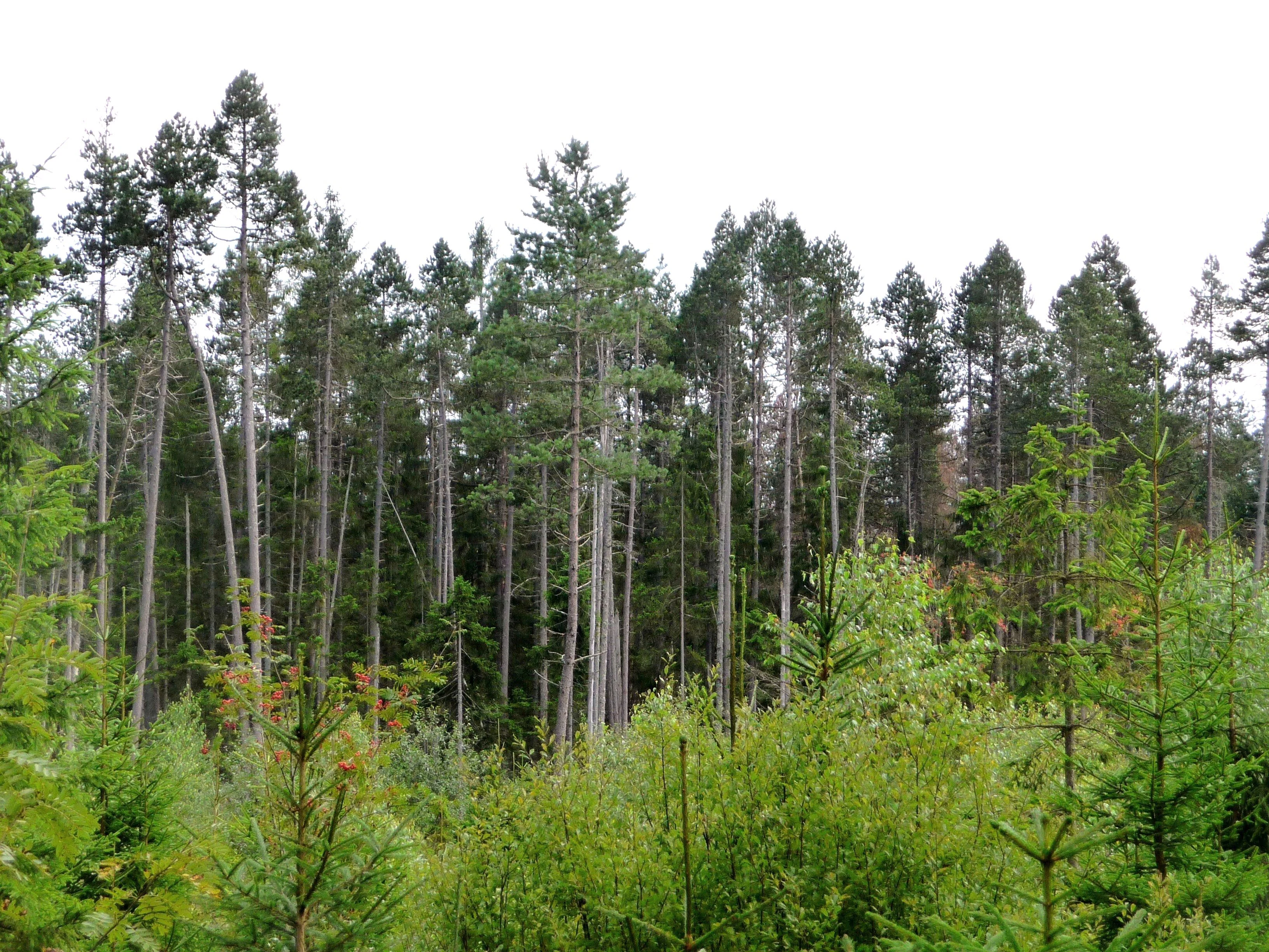
A dense stand of tall, slender evergreen trees in the Rotfilz nature reserve, with smaller pine shrubs in the foreground.
The dense, evergreen forest landscape of the Rotfilz nature reserve in Bavaria, Germany.

Rotfilz history and protected-area timeline

The protection history of Rotfilz began on 17 May 1973, when 13.5 hectares of the larger moorland complex were formally designated as a Naturschutzgebiet under Bavarian nature conservation law. This relatively early designation, during the consolidation of formal site-by-site nature conservation in West Germany in the early 1970s, gave the reserve one of the longer continuous protection records among low-elevation Bavarian Forest bogs.

Scientific interest in the site has a longer prehistory. Pollen-analytical and vegetation-history research at Rotfilz contributed to broader studies of late- and post-glacial forest history in the Bavarian Forest, notably in the 1987 doctoral work by Hartmut Stalling on late- and post-glacial vegetation history in the region. These studies established the site as an important reference profile for understanding how forest, mire, and peatland communities in this part of the Bohemian Massif responded to climate shifts at the end of the Pleistocene and through the Holocene.

In more recent decades, the management emphasis at Rotfilz has shifted towards active restoration. Rather than purely fencing off the site, conservation managers have sought to address the long legacy of peat cutting and drainage by infilling old ditches and gradually rewetting parts of the reserve, a hydrological restoration philosophy aligned with broader European efforts to recover functional peatland ecosystems.

Rotfilz landscape and geographic character

The Rotfilz sits on a relatively flat valley floor at roughly 600 metres elevation, embedded in the broader valley system of the Großer Regen. Because moors of this type form where water accumulates in topographic lows over imper substrates, the surrounding landforms are gentle: low valley-side slopes of Pleistocene slope loam and alluvial fan deposits, overlooked by the forested ridges of the inner Bavarian Forest. The South-facing limit of the mire is defined by the Stegaubachl, a small stream course, giving the reserve a clear hydrological boundary on one side.

In the wider valley context, the moor may be reached from the small settlement of Ludwigsthal, lying northwest of Zwiesel, and across the river from the mouth of the Große Deffernik. These geographic references help fix the moor location in the mind, even though much of the surrounding terrain is forested and the mire itself is not strongly scenic in the iconic mountain sense.

The visual character of the site, however, is distinctive in its own way. Open or semi-open mire vegetation with raised hummocks, interspersed stands of the characteristically rounded, dark-toned bog pines, and the linear scars of old drainage channels produce a texturally varied landscape that is more reminiscent of a Northern European or sub-Atlantic raised-bog scene than of the surrounding spruce-dominated Bavarian Forest hillsides.

Rotfilz ecosystems, habitats, and plant life

Ecologically, Rotfilz represents a low-elevation Central European valley mire, with elements typical of both transitional bog and more ombrotrophic raised bog vegetation. The forest matrix of the wider moorland is dominated by conifers that have been actively managed for timber, with drainage channels cutting through much of the outer area, so the broader bog landscape reads as a semi-natural cultural ecosystem rather than pristine wilderness.

The protected core of the reserve is ecologically richer. It supports the characteristic vegetation zonation of sub-montane Central European raised bogs: hummock communities with Sphagnum and other peat-building mosses, pools and muddy hollows, ericaceous dwarf shrubs (such as bog heather communities typical of acid peat), and stands of bog pine. The bog pine (Moor-Spirke, Pinus mugo subsp. rotundata), a subspecies of mountain pine that tolerates waterlogged, acidic peat soils better than spruce, is the diagnostic tree of these mires. In Rotfilz it reaches unusually well-developed, tree-sized specimens, persisting on stable peat surfaces where other trees would fail.

The site's protected-area classification under IUCN Category IV recognises its role as a habitat-and-species management area, in which the primary long-term objective is to maintain and restore the habitat itself, along with its characteristic flora and fauna, rather than to allow purely ecological processes to operate without intervention.

Rotfilz wildlife and species highlights

Rotfilz is primarily valued as a habitat rather than as a charismatic wildlife destination, and the available source material does not provide detailed species inventories. Its ecological importance lies more in underpinning peatland biodiversity, including invertebrates, bog-specialist plants, and birdlife associated with open mire mosaics, than in supporting high-profile mammals. The bog pine stands and open mire surfaces would, in this kind of Central European valley habitat, typically support bog-specialist invertebrates and ground-nesting or stopover bird species, but specific records for Rotfilz are not detailed in the source.

Its larger significance is as a protected refuge for the ecological communities characteristic of low-elevation raised bogs in the Bavarian Forest, an ecosystem type that, like most peatlands in densely settled Central Europe, has been reduced to fragments over centuries of drainage and peat cutting.

Rotfilz conservation status and protection priorities

The conservation significance of Rotfilz lies primarily in its function as one of the few formally protected raised bog fragments in the inner Bavarian Forest and as a reference site for mire hydrology, peat-forming vegetation, and bog pine woodland at relatively low elevation. Designated in 1973, it predates many of the larger landscape-level conservation initiatives in the region and has provided a continuous legal basis for habitat protection across several decades.

Management practice at the reserve reflects an active rather than passive approach to conservation. The presence of historic drainage channels across the wider moorland is a clear sign of past peat cutting and forestry drainage, both of which disrupted the bog's water balance and altered its vegetation. In response, conservation managers have undertaken targeted restorative action by infilling drainage ditches, a technique that aims to raise the water table within the protected zone and re-establish conditions favourable to Sphagnum peat growth and to bog pine regeneration. This makes Rotfilz a small-scale but instructive example of European raised-bog restoration work.

Its IUCN Category IV designation frames it explicitly as a Habitat/Species Management Area, consistent with a site where the primary conservation objective is to safeguard a particular habitat and its characteristic species assemblage, rather than to manage a large-scale natural process area.

Top sights and standout views in Rotfilz

What truly distinguishes Rotfilz, despite its small size, is the unusually well-developed bog pine woodland within its protected core. Specimens of Pinus mugo subsp. rotundata reach roughly ten metres in height, a stature rarely matched elsewhere in this part of the Bavarian Forest and the visual signature of the site.

Equally notable is the site's blend of relict and actively restored mire ecology: a long-protected (since 1973) fragment of once much more extensive valley peatland, in which ongoing ditch-filling and rewetting are gradually renewing conditions for peat formation. Together, the mature bog pines, the Pleistocene-lineage peat profile, and the visible restoration works make Rotfilz a compact but unusually informative site for understanding Central European raised bog conservation.

Best time to visit Rotfilz

As a low-elevation valley mire in the inner Bavarian Forest, Rotfilz is best experienced in the warmer months, from late spring through early autumn, when peatland vegetation is most evident and the bog pine stands can be approached without deep winter snow or frozen ground. Late spring and early summer are particularly favourable for appreciating the green tones of active bog vegetation, while late summer and early autumn tend to bring clearer weather and stronger colour contrast between the dark bog pines, the lighter mire surfaces, and the surrounding forest canopy.

Visiting in winter can also be rewarding in its own way, when snow highlights the open structure of bog pine woodland and the topography of the mire hummocks, but peatland surfaces can be waterlogged even outside the frost season, so sturdy footwear is advisable year-round.

Monthly climate preview

Long-term representative monthly temperature and precipitation averages for Rotfilz

Rotfilz Climate Normals and Measured Annual Temperature Rhythm

Representative coordinate records show measured monthly temperature and precipitation fluctuations across the annual cycle at a base elevation of 571 meters. Detailed monthly comparisons provide complete statistical context for average minimum and maximum thresholds throughout the entire yearly sequence.
Annual mean8 °C
-3 °C18 °C
Jan-3°
Feb-2°
Mar
Apr
May12°
Jun16°
Jul18°
Aug18°
Sep13°
Oct
Nov
Dec-2°
Warmest month
July

17.8 °C

Coolest month
January

-3 °C

Wettest month
June

3.2 mm/day

Driest month
April

1.6 mm/day

Park location guide

Geography guide, regional context, and park location map for Rotfilz

Rotfilz park geography, regions, and map view in Germany

Understand where Rotfilz sits in Germany through a broader geographic reading of the surrounding landscape, nearby location context, and its mapped position within the national park landscape.

How Rotfilz fits into Germany

Germany is a federal republic in Western and Central Europe with a population of over 83 million across sixteen constituent states. It is Europe's largest economy by nominal GDP and a major global exporter and importer. The capital is Berlin, and the country borders Denmark, Poland, Czech Republic, Austria, Switzerland, France, Luxembourg, Belgium, and the Netherlands.

Wider geography shaping Rotfilz in Germany

Germany is located in Western and Central Europe, spanning 357,022 km². It borders Denmark to the north, Poland and the Czech Republic to the east, Austria and Switzerland to the south, and France, Luxembourg, Belgium, and the Netherlands to the west. The country has coastlines on the Baltic Sea and North Sea to the north, with the Alps located in the southern region.

Map view of Rotfilz

Use this park location map to pinpoint Rotfilz in Germany, understand its exact geographic position, and read its mapped placement within the surrounding landscape more clearly.

Pigeon | © OpenStreetMap contributors

Location context for Rotfilz

BavariaLandkreis Regen

Explore detailed imagery of rare bog pine stands, valley mire terrain, and protected wetland habitats.

Rotfilz Photos and Landscapes: Visualizing the Bavarian Forest Peatland

Visual records capture the distinctive vegetation and unique topography of Rotfilz, highlighting mature bog pine woodlands across the protected Bavarian Forest valley floor. Photographic observation reveals essential ecological features, including relict peat formations and active wetland restoration measures.

A dense stand of tall, slender evergreen trees in the Rotfilz nature reserve, with smaller pine shrubs in the foreground.

Park atlas

Compare surrounding nature reserves and connected valley mire landscapes

Parks Near Rotfilz, Exploring Protected Areas and Regional Valleys

Browse nearby national parks and protected areas to compare valley floor habitats across the surrounding Bavarian Forest region. Regional park exploration connects isolated peatland reserves with wider forest ecosystems for comprehensive geographic study.
Watercolor painting showing mountains, forests, and valleys in a landscape.
National parkGermany
About 0.5 km away#1 closest

Southeast

Bavarian Forest National Park: Protected Landscape and Regional Geography Atlas

Explore mapped terrain and protected park boundaries in Germany.

Dive into the specifics of Bavarian Forest National Park, a key protected area noted for its distinct landscape and geographic importance. This MoriAtlas entry details the park's mapped boundaries and its setting within the surrounding regional geography, offering a clear atlas-style view of its natural terrain. Understand its identity as a national park and discover its place in Germany's protected lands.

Area
242.45 km²
Established
1970
IUCN
II
Visitors
1.3M annual
Watercolor illustration of a river flowing through a forested landscape with rolling hills in the background
National parkSouth Bohemian Region
About 5.8 km away#2 closest

Southeast

Šumava National Park: Czech Republic's Premier Forested National Park and Protected Landscape

Explore the unique glacial lakes, peat bogs, and regional geography.

Šumava National Park, situated in the South Bohemian Region of the Czech Republic, is the nation's largest protected area and a vital component of Central Europe's forest ecosystems. This entry details its expansive terrain, highlighting the significant peat bog complexes and ancient glacial lakes that define its unique landscape. Discover the park's geographic context, mapped boundaries, and its importance as a protected natural asset within the broader regional atlas.

Area
680.64 km²
Established
1991
IUCN
II
Visitors
2M annual
A horizontal watercolor painting depicting a soft, atmospheric landscape with a foreground of purple and pink wetland grasses, a midground of scattered green coniferous trees, and hazy, distant mountain silhouettes in the background.
Nature reservePlzeňský kraj
About 15 km away#3 closest

North

Prameniště Nature Reserve: Protected Wetland and Mountain Spring Systems in Plzeňský kraj

Mapping the hydrological headwaters of the Šumava Mountains

Prameniště Nature Reserve represents a critical cluster of protected mountain springs and peat bogs across the Pancířský hřbet ridge. By focusing on the source areas for the Křemelná and Řezná rivers, this reserve maintains essential hydrological integrity within the wider Plzeňský kraj landscape. Its mosaic of sub-alpine peatlands and montane spruce forests provides an important study of high-altitude wetland geography in the central European mountains.

Area
3.536 km²
Established
1994
IUCN
IV
Relief
Mountain
Watercolor painting of a grassy meadow bordered by a forest line with soft green and muted earth tones.
Nature reserveJihočeský kraj
About 30 km away#4 closest

East

Rašeliniště u Martinala: A Protected Nature Reserve in the Jihočeský kraj Foothills

Mapping transitional bog ecosystems and submontane habitats

Located in the Šumava foothills, Rašeliniště u Martinala is a protected nature reserve defined by its dual-parcel structure of peat-forming wetlands and juniper-rich dry grasslands. This site acts as a key ecological node, supporting a high density of protected species within the Jáchymovský potok drainage basin and representing a refined example of south Bohemian submontane landscape character.

Area
0.095 km²
Established
2011
IUCN
IV
Relief
Upland
A horizontal watercolor painting showing rolling green hills and distant purple ridges against a white background.
Protected landscapeKlatovy District
About 35 km away#5 closest

Northeast

Přírodní park Buděticko: Protected Landscape and Geographic Atlas of Klatovy District

Orchid-rich meadows and riparian terrain in the Bohemian foothills

Přírodní park Buděticko serves as a vital protected landscape in the Klatovy District, characterized by the transition between the Šumava foothills and broader upland plains. This area supports a mosaic of orchid-rich limestone meadows and riparian habitats along the Otava River. Discover the park's geological character and its integration of natural biodiversity with the cultural heritage of southwestern Bohemia.

Area
44 km²
Established
1994
Relief
Upland
Climate
Temperate
A watercolor painting showing a panoramic view of a green wetland area with trees, grass, and rolling hills in the background.
Nature reserveJihočeský kraj
About 35 km away#6 closest

East

Pravětínská Lada Nature Reserve: Geography and Protected Area Landscape Context

Wetland mosaics and peat bog terrain in the South Bohemian Region

Pravětínská Lada serves as a vital protected landscape where peatland and spring headwater ecosystems meet recovering farmland. Located in the Jihočeský kraj, this nature reserve demonstrates how small-scale terrain variations and moisture gradients support high ecological density within the wider Bohemian Forest. The site provides a concentrated look at the transitional boundary between wetland communities and secondary meadows.

Area
0.516 km²
Established
2000
IUCN
IV
Relief
Upland
A horizontal watercolor illustration depicting soft, rolling hills in shades of green, yellow, and light pink with small clusters of trees.
Nature reservePlzeňský kraj
About 43 km away#7 closest

Northeast

Prácheň Nature Reserve: Protected Broadleaf Woodlands and Historic Castle Remains

An atlas view of Bohemian forest geography and heritage landscapes

Prácheň Nature Reserve protects a compact block of warm-loving deciduous woodland set atop a hilltop in the Plzeňský kraj region. The area integrates significant natural habitats with cultural heritage, encompassing an early medieval hillfort and castle ruins. This unique blend of forest ecology and Bohemian historical geography offers a distinct perspective on protected areas within the southwestern Czech landscape.

Area
0.283 km²
Established
1953
IUCN
IV
Relief
Upland
A soft watercolor illustration depicting a panoramic mountain landscape with evergreen trees in the foreground and rolling hills in the background in pastel shades of green, yellow, and pink.
Protected landscapeBavaria
About 44 km away#8 closest

Northwest

Naturpark Oberer Bayerischer Wald: Protected Landscape Geography and Map

Mountain summits, river wetlands, and quartzite ridges in Bavaria

Spanning over 1,700 square kilometers, Naturpark Oberer Bayerischer Wald stands as a major protected area in Bavaria. This territory features a complex interplay of high-altitude forest, glacial lake basins, and unique geological landmarks including the 150-kilometer Pfahl ridge. Discover how these diverse landscapes, ranging from alpine terrain to river floodplains, are mapped and preserved within this significant regional protected zone.

Area
1,733 km²
Established
1989
Relief
Mountain
Climate
Temperate

Common questions about visiting, size, designation, and location context for Rotfilz

Rotfilz FAQs for park facts, access, geography, and protected area context

Find quick answers about Rotfilz, including protected-area facts, park geography, trail and visitor context, and how the park fits into its surrounding country and regional landscape.
MoriAtlas Explorer

Continue Your Protected Areas Search Across the Global Atlas

Deepen your exploration by continuing the structured search for national parks and protected areas worldwide. Utilize the comprehensive filtering capabilities to compare different conservation landscapes and refine your understanding of global park geography. Discover more about the distribution and characteristics of protected natural areas.

Global natural geography