
Mori Atlas logo
Wildlife reserveRound Island Wilderness

Mapping the ecological gradient from cobblestone shores to mature beech and maple forests

Round Island Wilderness: A Compact Protected Landscape in the Straits of Mackinac

Round Island Wilderness represents a distinct, uninhabited protected area located within the Straits of Mackinac, Michigan. This wildlife reserve functions as a microcosm of northern Great Lakes environments, featuring a dense vertical ecological transition from coastal marsh and cobblestone shoreline through conifer-dominated slopes to a high plateau of mature hardwoods. The geography remains largely untouched, providing a stark environmental contrast to the busy maritime corridors that surround its perimeter within the Hiawatha National Forest.

wilderness areauninhabited islandGreat LakesStraits of MackinacLake HuronHiawatha National Forest
A flat-style digital illustration showing a winding path along a coastline, a tall cliff with a waterfall, a lighthouse on a rocky point, and pink-tinted clouds in a light blue sky.

Round Island Wilderness

Wildlife reserve

Park overview

Structured park overview, official facts, and landscape profile for Round Island Wilderness

Round Island Wilderness park facts, protected area profile, and essential visitor context

Review the core facts for Round Island Wilderness, including designation, size, terrain, visitor scale, habitats, and operating context in one park-focused overview.

About Round Island Wilderness

Round Island Wilderness is one of the smallest and most distinctive wilderness areas in Michigan's national forest system, occupying nearly an entire island where Lake Michigan and Lake Huron meet. The protected area sits within the Hiawatha National Forest and is administered by the U.S. Forest Service, even though, for municipal purposes, the island belongs to the City of Mackinac Island. The wilderness designation preserves a place where the developed tourist world of Mackinac Island fades almost immediately into wild, roadless forest, marsh, and lakeshore.

The island's significance lies not in its size, but in the compressed ecological diversity it holds within that small footprint. From cobblestone-and-sand beaches and marshy margins, the terrain rises through a conifer forest of northern whitecedar, white spruce, and white pine into a high interior plateau of mature beech-maple hardwoods. American beech, sugar maple, and paper birch dominate this upper zone, although beech stands have suffered significant disease pressure in the 21st century.

In addition to its natural character, Round Island plays a navigational and cultural role at the entrance to Mackinac Island's harbor. The Round Island Channel between the two islands is the main ferry route connecting visitors to Mackinac Island, and the 1895 Round Island Light marks this passage. The island's Native name, Nissawinagong, reflects its long-standing presence in the Indigenous geography of the straits, while its wilderness status, achieved through inclusion in the Hiawatha National Forest, places it within a modern federal framework of ecological preservation.

Quick facts and research context for Round Island Wilderness

Round Island Wilderness covers almost all of a 378-acre uninhabited island in Mackinac County, Michigan, in the Straits of Mackinac between Lake Michigan and Lake Huron. It is administered as part of the Hiawatha National Forest by the U.S. Forest Service, even though the island is nominally part of the City of Mackinac Island. The wilderness preserves a layered habitat mosaic of cobblestone and sand beach, marshy shore, conifer forest dominated by northern whitecedar, white spruce, and white pine, and an interior beech-maple forest of sugar maple, paper birch, and American beech. The only non-wilderness parcel is the 1895 Round Island Light, which guides vessel traffic through the Round Island Channel leading to Mackinac Island.

Protection and recognition

Terrestrial protected area management scope and official designation records

Round Island Wilderness Protection Status and International Recognition

Round Island Wilderness maintains a documented terrestrial protection scope within the global conservation database framework. Official records outline baseline designation criteria and administrative recognition parameters for this protected landscape.

Protection details

Protection scope
Terrestrial
Transboundary protection
No
Park context

Deeper park guide and search-rich context for Round Island Wilderness

Round Island Wilderness history, landscape, wildlife, and travel context

Explore Round Island Wilderness through its history, landscape character, ecosystems, wildlife, conservation priorities, cultural context, and seasonal travel timing in a structured park guide built for atlas discovery and search intent.

Why Round Island Wilderness stands out

Round Island Wilderness is best known for its compact, layered Great Lakes island ecology: a cobblestone and sandy shoreline giving way to boreal-feeling conifer forest of northern whitecedar, white spruce, and white pine, capped by a mature beech-maple hardwood interior. It is also known for its dramatic geographic setting, sitting directly in the Straits of Mackinac where hundreds of thousands of ferry passengers pass by each year while the island itself remains essentially unvisited. The 1895 Round Island Light, the only developed structure on the island, anchors the landscape visually and historically, and the wilderness area encircles it on otherwise untouched ground.
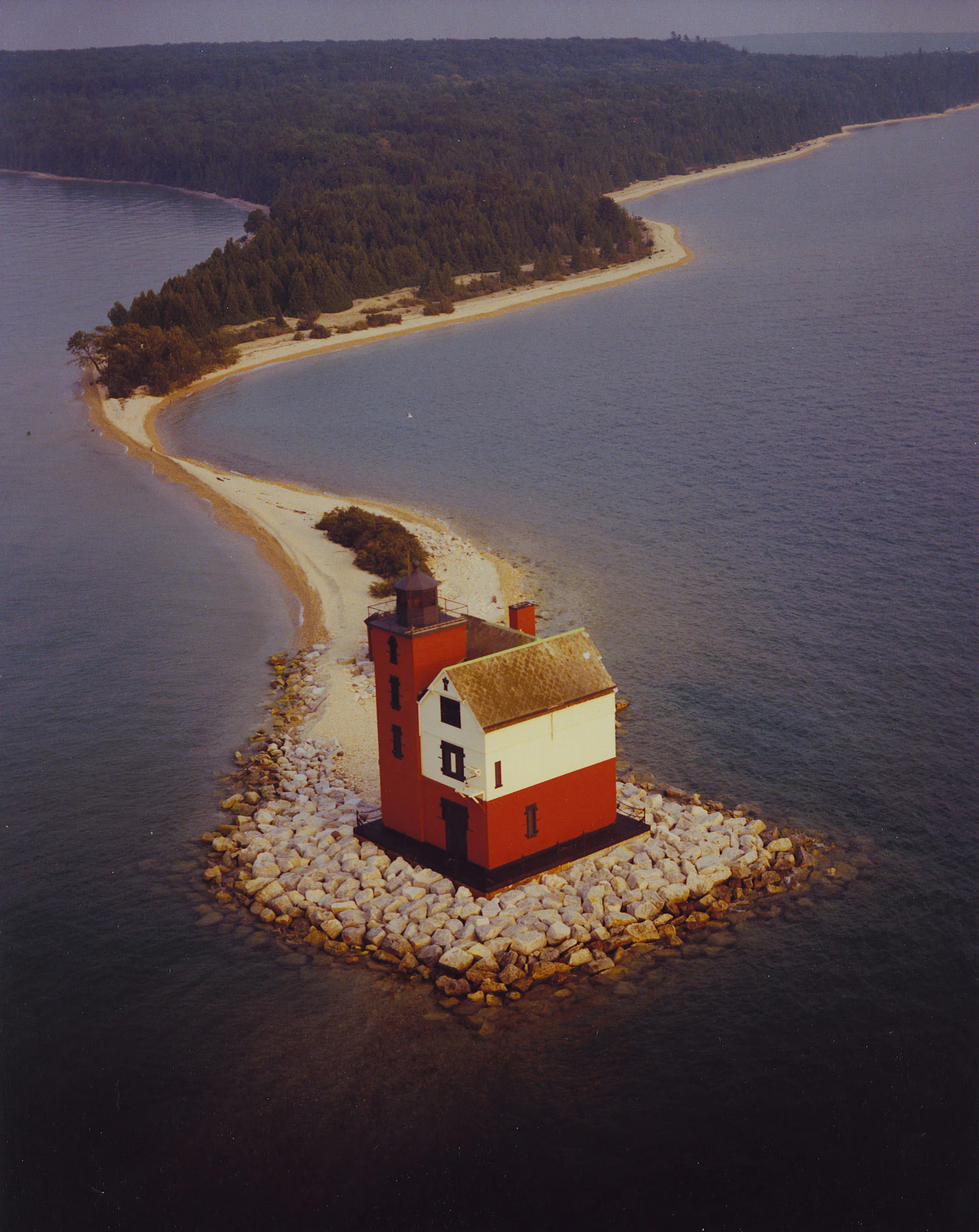
An aerial view of the red and white Round Island Lighthouse situated on a rocky foundation at the end of a long, curving sandy beach and forested island.
The historic Round Island Lighthouse perched on the tip of the sand spit in Round Island Wilderness.

Round Island Wilderness history and protected-area timeline

Round Island has long been a navigational landmark in the Straits of Mackinac, where vessels pass between Lake Michigan and Lake Huron. Its deep-rooted presence in the region is reflected in the Native American name Nissawinagong. The island's strategic position at the mouth of the harbor approach to Mackinac Island led to the construction of the Round Island Light in 1895, which still stands as the only developed structure on the island and guides ships through the Round Island Channel.

In the modern era, Round Island's significance shifted from purely navigational to ecological. The island was incorporated into the Hiawatha National Forest under the administration of the U.S. Forest Service, and almost the entire island was designated as wilderness, leaving only the lighthouse parcel excluded. This designation formally protected the island's shoreline, mixed conifer forest, and mature beech-maple interior from development, even as nearby Mackinac Island continued to develop as a major tourist destination.

Round Island Wilderness landscape and geographic character

Round Island is a small but topographically varied Great Lakes island set in the swift, cold waters of the Straits of Mackinac. Its shoreline is a striking combination of cobblestone, mixed cobblestone-and-sand, and sandy beach, particularly along a small northeast-shore cove that draws occasional quiet visitors from nearby Mackinac Island. Marshy shore fringes parts of the island, blurring the line between open water and inland vegetation.

From the shore, the island rises into a conifer forest zone characterized by northern whitecedar, white spruce, and white pine, species typical of cooler northern Great Lakes environments. The high point of the island carries a more classically northern-hardwoods character, with a mature beech-maple forest dominated by sugar maple, paper birch, and American beech. This layering of rocky beach, conifer slope, and hardwood plateau creates a distinctly vertical ecological gradient within a very compact land area.

Round Island Wilderness ecosystems, habitats, and plant life

The ecological identity of Round Island Wilderness is shaped by the compression of multiple Great Lakes habitat types into a small island. The shoreline alternates between cobblestone, mixed cobble-and-sand, and sand, with marshy margins where wetland vegetation meets the lakeshore. These open shore and marsh zones form a transitional edge between aquatic and terrestrial systems and are ecologically important despite their narrow footprint.

Inland, the vegetation reflects a strong northern character. The lower slopes support a conifer forest of northern whitecedar, white spruce, and white pine, classic species of the upper Great Lakes. Higher on the island, a mature beech-maple forest takes over, with sugar maple and paper birch as the principal trees alongside American beech. The beech population has been notably affected by disease in the 21st century, a pressure that has altered parts of the interior canopy and added an element of ecological change to the otherwise stable wilderness.

The combination of essentially roadless Great Lakes island habitat, varied shoreline types, and two distinct forest zones makes the wilderness an unusually concentrated example of northern Great Lakes ecology.

Round Island Wilderness wildlife and species highlights

Wildlife information specific to Round Island Wilderness is limited in the source material, and no detailed inventory of mammal, bird, or reptile species is provided. The island's mix of beach, marsh, conifer forest, and beech-maple hardwood would be expected to support typical northern Great Lakes island wildlife, including songbirds associated with both coniferous and deciduous forest, waterbirds along the shoreline and in the surrounding straits, and small mammals adapted to lake-island environments. However, because the source pages do not document specific species reliably, this profile does not invent a detailed species list.

Round Island Wilderness conservation status and protection priorities

The principal conservation significance of Round Island Wilderness is its status as a protected wilderness area within the federal National Forest System. Almost the entire island lies within the Hiawatha National Forest and carries a wilderness designation that shields its cobblestone and sand shoreline, marshy margins, conifer forest, and beech-maple interior from development.

This designation is notable because it preserves a wild, road-free island in one of the most heavily visited corridors of the upper Great Lakes. While hundreds of thousands of ferry passengers pass nearby each year en route to Mackinac Island, the wilderness area itself essentially sees no regular visitors. The single developed parcel, the Round Island Light and its grounds, is excluded from wilderness status but remains the only human-built feature on the island. Disease-driven decline in the beech population in the 21st century has emerged as an additional conservation concern within the otherwise stable protected landscape.

Round Island Wilderness cultural meaning and human context

Round Island carries a layered human and cultural presence even though it has no permanent population. The Native American name Nissawinagong attests to the island's longstanding place in Indigenous geographies of the Straits of Mackinac, where Lake Michigan and Lake Huron meet. In the European-American era, the island became a maritime landmark, with the construction of the 1895 Round Island Light tying it to the broader navigational and commercial history of the straits.

The island also has a niche place in American popular culture. Scenes from the 1980 film Some in Time, starring Christopher Reeve and Jane Seymour, were shot near the lighthouse on Mackinac Island and feature the pair sitting near the Round Island Light. Although the film was made on neighboring Mackinac Island, it brought a wider cultural visibility to the Round Island Light and the surrounding waters. Today the island remains overwhelmingly defined by its wilderness character rather than by human visitation.

Top sights and standout views in Round Island Wilderness

The most distinctive feature of Round Island Wilderness is the way multiple Great Lakes habitat types fit into a single small island: cobblestone and sand beach, marshy shore, a conifer zone of northern whitecedar, white spruce, and white pine, and a high interior of mature beech-maple forest. Equally distinctive is the contrast between the island's untouched state and the intense human activity flowing past it, since the ferry route to Mackinac Island passes directly through the Round Island Channel.

The 1895 Round Island Light is both a visual anchor and a reminder of the island's navigational role. Despite sitting in one of the busiest tourist corridors of the upper Great Lakes, the island itself receives virtually no visitors, reinforcing the wilderness area's character as a place where the heavily visited straits remain, in ecological reality, a quiet edge of wild northern lake country.

Best time to visit Round Island Wilderness

Because Round Island Wilderness is essentially unvisited and has no public facilities, formal seasonal visitation guidance is not strongly supported by the source material. In general terms, the upper Great Lakes region around the Straits of Mackinac is most accessible by boat during the warmer months, when ferry traffic to Mackinac Island is operating and lake conditions are calmer. Spring and early summer can highlight fresh shoreline vegetation and active waterbird movement, while late summer and early fall typically bring stable weather and warm water. Winter conditions in the straits are harsh, and the island is even more remote in the cold season. Anyone considering a visit should be aware that the wilderness receives almost no regular visitors and that reaching the small northeast-shore cove requires private boat access from Mackinac Island.

Monthly climate preview

Long-term temperature ranges and monthly precipitation averages recorded at a representative point

Round Island Wilderness Climate Normals and Measured Annual Weather Patterns

Representative coordinate records show measured monthly temperature variations and precipitation totals spanning standard climatology baselines for Round Island Wilderness. Detailed monthly climate profiles provide complete twelve-month temperature extremes and precipitation averages across the protected landscape.
Annual mean6 °C
-7 °C18 °C
Jan-7°
Feb-7°
Mar-3°
Apr
May
Jun14°
Jul18°
Aug18°
Sep15°
Oct
Nov
Dec-3°
Warmest month
August

18.3 °C

Coolest month
January

-7.1 °C

Wettest month
October

3.3 mm/day

Driest month
February

1.3 mm/day

Park location guide

Geography guide, regional context, and park location map for Round Island Wilderness

Round Island Wilderness park geography, regions, and map view in United States of America

Understand where Round Island Wilderness sits in United States of America through a broader geographic reading of the surrounding landscape, nearby location context, and its mapped position within the national park landscape.

How Round Island Wilderness fits into United States of America

The United States of America is a federal presidential republic and one of the world's largest countries by area and population. It consists of 50 states across a vast territory spanning multiple time zones, with its capital in Washington, D.C. and largest city in New York City. The nation has a diverse economy, influential political system, and significant cultural and military presence globally.

Wider geography shaping Round Island Wilderness in United States of America

The United States occupies a vast territory in North America, bordered by Canada to the north and Mexico to the south. The 48 contiguous states stretch from the Atlantic to the Pacific Ocean, while Alaska occupies the northwestern region and Hawaii is an archipelago in the Pacific. The country encompasses diverse terrain including the Rocky Mountains, Appalachian Mountains, Great Plains, and extensive river systems.

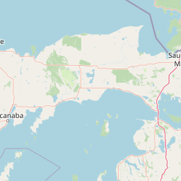
Map view of Round Island Wilderness

Use this park location map to pinpoint Round Island Wilderness in United States of America, understand its exact geographic position, and read its mapped placement within the surrounding landscape more clearly.

Pigeon | © OpenStreetMap contributors

Visualizing the terrain, shoreline habitats, and isolated forest character of an undisturbed island sanctuary.

Round Island Wilderness Photos and Scenery: Exploring the Protected Great Lakes Island Landscapes

Examine detailed imagery showcasing the rugged cobblestone shores, dense conifer stands, and mature hardwood interiors that define this unique protected island environment. Visual records reveal the striking contrast between wild northern ecosystems and the busy shipping lanes of the surrounding straits.

An aerial view of the red and white Round Island Lighthouse situated on a rocky foundation at the end of a long, curving sandy beach and forested island.

Park atlas

Compare regional park geography and connected protected landscapes

Other Parks Near Round Island Wilderness and Surrounding Protected Areas

Explore protected areas near the surrounding region to compare island ecosystems and northern forest habitats. Continuing past Round Island Wilderness reveals broader regional geography across the upper Great Lakes.
A watercolor painting of a rolling, soft-toned landscape with a foreground of green forest and layers of hills receding into the distance.
Protected landscapeUpper Peninsula of Michigan
Mapped location lies within the park boundary#1 closest

West

Hiawatha National Forest: Geographic Overview and Protected Area Map of the Upper Peninsula

Coastal forest landscape and wilderness river corridors.

Hiawatha National Forest spans significant portions of the Upper Peninsula of Michigan, bridging the gap between northern hardwood forests and the boreal environments of the Great Lakes. This protected landscape encompasses extensive shorelines along Lake Superior, Lake Michigan, and Lake Huron, alongside six wilderness areas and five designated wild and scenic rivers.

Area
3,621.27 km²
Established
1931
IUCN
VI
Relief
Lowland
Wildlife reserveMichigan
About 16 km away#2 closest

Northwest

Horseshoe Bay Wilderness: A Detailed Geographic Overview of Michigan Protected Lands

Protected wetland habitat and Lake Huron coastal geography

Horseshoe Bay Wilderness represents a pristine 3,787-acre protected area located along the northwestern corner of Lake Huron in Michigan. Administered as part of the Hiawatha National Forest, this wilderness features an intricate post-glacial landscape of riparian wetlands, dense northern whitecedar stands, and quiet shallow waters that serve as vital spawning ground for local aquatic life.

Area
15.33 km²
Established
1987
IUCN
Ib
Relief
Lowland
Marine protected areaMichigan
About 21 km away#3 closest

Southeast

Thunder Bay National Marine Sanctuary: Geography and Protected Maritime Landscape Context

Mapping underwater heritage in the Michigan Great Lakes region

Spanning 4,300 square miles of Lake Huron, Thunder Bay National Marine Sanctuary preserves a significant collection of shipwrecks within a glacially shaped freshwater terrain. This marine protected area offers a look at submerged geography ranging from shallow coastal bays to deep lake basins. It serves as a vital anchor for understanding maritime history and freshwater ecosystem stability across the Michigan shoreline.

Area
11,000 km²
Established
2000
Relief
Lowland
Climate
Temperate
Wildlife reserveMichigan
About 28 km away#4 closest

Northwest

Mackinac Wilderness Protected Area: Glacial Terrain and River Geography in Upper Michigan

A roadless wilderness reserve within Hiawatha National Forest

Uncover the geographic significance of Mackinac Wilderness, an IUCN Category Ib protected area in Michigan. The unit provides a distinct look at northern forest recovery through a terrain of sandy ridges, aspen and birch cover, and aquatic corridors. This study examines the interplay between postglacial landforms and the ongoing natural succession occurring along the Carp River drainage basin.

Area
49.5 km²
IUCN
Ib
Relief
Lowland
Climate
Temperate
A soft watercolor painting showing green rolling hills, a calm body of water, and small clusters of pink flowers against a light, hazy background.
National parkMichigan
About 132 km away#5 closest

Southwest

Sleeping Bear Dunes National Lakeshore: Atlas, Maps, and Protected Landscape Geography

Great Lakes freshwater coast and glacial dune systems

Sleeping Bear Dunes National Lakeshore showcases the unique intersection of glacial geology and freshwater ecology. This protected area features massive dunes resting on ancient glacial deposits, backed by beech and maple forests. The geographic scope includes the vast shoreline of Lake Michigan, inland waters such as Glen Lake, and the distinct maritime history found across the remote North and South Manitou Islands.

Area
288.13 km²
Established
1970
IUCN
III
Visitors
1.5M annual
Marine protected areaMichigan
About 140 km away#6 closest

Southeast

Thunder Bay National Marine Sanctuary and Underwater Preserve: Geography and Protected Area Atlas

Maritime heritage sites and glacial freshwater geography in Lake Huron, Michigan.

Situated along the rugged northeastern coast of Lake Huron, Thunder Bay National Marine Sanctuary and Underwater Preserve protects over two hundred shipwreck sites spanning nearly two centuries of maritime history. This marine protected area offers a unique intersection of submerged archaeological resources, shallow shoals, coastal marshes, and limestone bedrock, forming a vital freshwater ecosystem in the Great Lakes region of Michigan.

Area
11,000 km²
Established
2000
Relief
Lowland
Climate
Temperate
A horizontal watercolor painting showing a quiet lake surrounded by light green pine trees and soft, rolling hills in the distance.
Protected landscapeMichigan
About 148 km away#7 closest

South

Huron, Manistee National Forests: Geography, Protected Land, and Michigan Landscape Atlas

Exploration of glacial terrain, river basins, and coastal wilderness.

The Huron, Manistee National Forests stand as a significant protected landscape in northern Michigan, featuring a vast network of inland rivers and lakes. This atlas entry provides geographic context on its glacial geology, the rare dune ecosystems along Lake Michigan, and the distribution of pine-dominated forest habitats across the two administrative units.

Area
3,960 km²
IUCN
VI
Relief
Lowland
Climate
Temperate
A watercolor painting showing a rolling landscape with green fields, sandy dunes, and a purple mountain range in the distance.
Natural monumentAlger County
About 155 km away#8 closest

Northwest

Pictured Rocks National Lakeshore: Geographic Atlas of Cliffs and Shoreline Terrain

Protected landscape geography in Alger County, Michigan

Pictured Rocks National Lakeshore offers a deep look into the Great Lakes coastal geography. Explore the intersection of Cambrian-era sandstone cliffs, perched dune systems, and inland forested wilderness. This area provides a clear record of glacial and lake-driven erosion, featuring unique formations like Miners Castle and Chapel Rock across its extensive Lake Superior boundary.

Area
296.38 km²
Established
1966
IUCN
III
Visitors
953.1K annual

Common questions about visiting, size, designation, and location context for Round Island Wilderness

Round Island Wilderness FAQs for park facts, access, geography, and protected area context

Find quick answers about Round Island Wilderness, including protected-area facts, park geography, trail and visitor context, and how the park fits into its surrounding country and regional landscape.
MoriAtlas Explorer

Continue Your Protected Areas Search Across the Global Atlas

Deepen your exploration by continuing the structured search for national parks and protected areas worldwide. Utilize the comprehensive filtering capabilities to compare different conservation landscapes and refine your understanding of global park geography. Discover more about the distribution and characteristics of protected natural areas.

Global natural geography