Mori Atlas logo
Protected areaRównina Szubińsko-Łabiszyńska

Examining the ecological corridor of the Noteć river valley and peat-rich lowland meadows

Równina Szubińsko-Łabiszyńska: A Comprehensive Atlas of its Protected Landscapes and Geography

The Równina Szubińsko-Łabiszyńska represents a critical Natura 2000 site within the Kuyavian-Pomeranian Voivodeship. This protected area encompasses a complex mosaic of wet meadows, oak-elm-ash floodplain forests, and xerothermic vegetation shaped by the historic Górnonotecki Canal. The site functions as a vital ecological corridor, mapping the intersection of organic peat soils and riparian habitats that define the lowland terrain of central Poland.

Natura 2000river valleyNoteć riverpeat meadowsfloodplain meadowsriparian forests

Równina Szubińsko-Łabiszyńska

Protected area

Park overview

Structured park overview, official facts, and landscape profile for Równina Szubińsko-Łabiszyńska

Równina Szubińsko-Łabiszyńska park facts, protected area profile, and essential visitor context

Review the core facts for Równina Szubińsko-Łabiszyńska, including designation, size, terrain, visitor scale, habitats, and operating context in one park-focused overview.

About Równina Szubińsko-Łabiszyńska

Równina Szubińsko-Łabiszyńska is a Natura 2000 habitat protection site located in the flat lowlands of the Noteć river valley in north-central Poland. Working under the European identifier PLH040029, it is currently classified as a Site of Community Importance with the longer-term aim of becoming a Special Area of Conservation under the EU Habitats Directive. Its central purpose is to safeguard the natural habitats and the plant and animal species that depend on them in this part of the Noteć floodplain.

Geographically, the protected area sits in the Kotlina Toruńska macroregion of the Kuyavian-Pomeranian Voivodeship, southwest of the city of Bydgoszcz. The landscape consists of three fragments: a north-western section stretching along the meandering Noteć between Żurczyn, Chobielin, and Występ near Nakło nad Notecią, a south-eastern section from Pszczółczyn to Rynarzewo that includes the well-known Bydgoskie Łąki Nadnoteckie meadows, and a small southeastern enclave near Nowe Dąbie.

The land surface is strongly shaped by water. The valley floor is built of organic soils, predominantly lowmoor peat and muck, which have settled in the ancient Noteć floodplain. The Górnonotecki Canal, built between 1878 and 1882, runs through the area together with a dense network of drainage canals, weirs, and navigation locks. This nineteenth-century waterworks transformed the hydrology, converting the former floodplain into a system of regulated, meliorated meadows that have been used for agriculture.

Ecologically, Równina Szubińsko-Ŋbiszyńska is recognized for its large extent of wet grasslands, a quickFacts-eligible proportion of protected habitat, and the presence of protected species of amphibians and characteristic meadow flora. Its connectivity to neighbouring protected areas in the Noteć valley makes it an important national-level ecological corridor in northern Poland.

Quick facts and research context for Równina Szubińsko-Łabiszyńska

Równina Szubińsko-Łabiszyńska is a designated Site of Community Importance within the European Natura 2000 network, working toward Special Area of Conservation status with the code PLH040029. It lies in the Kuyavian-Pomeranian Voivodeship and falls geographically within the Kotlina Toruńska (Toruń Basin) macroregion of northern Poland.

The site consists of three separate fragments southwest of Bydgoszcz, crossed by the strongly meandering Noteć river and the historic Górnonotecki Canal, together with an extensive network of drainage canals, weirs, and navigation locks. Administratively it spans the Bydgoszcz, Żniń, and Nakło counties, including the municipalities of Białe Błota, Łabiszyn, Szubin, and Nakło nad Notecią.

Protection and recognition

Explore documented terrestrial protection metrics and international recognition frameworks

Równina Szubińsko-Łabiszyńska Protection Status and Natura 2000 Recognition

Równina Szubińsko-Łabiszyńska maintains documented terrestrial protection status supported by imported Natura 2000 recognition records. Structured governance data highlights official designation boundaries and administrative frameworks for conservation analysis.
Park context

Deeper park guide and search-rich context for Równina Szubińsko-Łabiszyńska

Równina Szubińsko-Łabiszyńska history, landscape, wildlife, and travel context

Explore Równina Szubińsko-Łabiszyńska through its history, landscape character, ecosystems, wildlife, conservation priorities, cultural context, and seasonal travel timing in a structured park guide built for atlas discovery and search intent.

Why Równina Szubińsko-Łabiszyńska stands out

Równina Szubińsko-Łabiszyńska is best known for its extensive lowland meadows on peat soils, including the so-called Bydgoskie Łąki Nadnoteckie (Bydgoszcz Noteć Floodplain Meadows). These meadows occupy the depression that runs along the Górnonotecki Canal and constitute one of the most recognizable wetland-grassland landscapes of the lower Noteć valley. The area is equally valued for its oak-elm-ash floodplain forests and oak-hornbeam woodlands that grow on slight rises within an otherwise flat, organic-soil plain. This combination of wet meadows, riparian forests, dry sandy outcrops with xerothermic vegetation, and canal-influenced hydrology gives the site an unusually varied habitat mosaic for a lowland river-plain protected area.
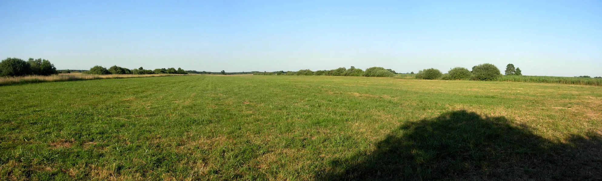
A wide, panoramic view of a vast, flat meadow with green grass stretching to the horizon under a clear blue sky, with a dark tree shadow in the foreground right.
Panoramic view of the Bydgoskie Laki Nadnoteckie meadows in Poland.

Równina Szubińsko-Łabiszyńska history and protected-area timeline

The present character of the site is inseparable from the late-nineteenth-century regulation of the Noteć floodplain. The Górnonotecki Canal was built between 1878 and 1882, turning the formerly free-flowing river into a navigable waterway and creating an extensive system of drainage canals, weirs, and shipping locks.

This hydraulic restructuring allowed the formerly flooding peat plain to be drained and converted into extensive meadows and pastures that could be used economically, while at the same time opening a shipping route connecting the Kuyavian and Pałuki lake districts with the Bydgoszcz Canal. It is this anthropogenically shaped but ecologically rich landscape that the Natura 2000 site was later designated to protect.

The area was formally designated as a Site of Community Importance (obszar mający znaczenie dla Wspólnoty) under the Natura 2000 network, with a creation date associated with the 2011 process that established many Polish habitat sites. The site now sits within a coordinated framework of protected areas along the middle and lower Noteć, including the adjacent Special Protection Area for birds of the Middle Noteć and Bydgoszcz Canal valley.

Równina Szubińsko-Łabiszyńska landscape and geographic character

The landscape of Równina Szubińsko-Łabiszyńska is a quintessential example of a lowland river-plain, dominated by an exceptionally flat valley floor rather than by hills or mountains. The terrain reflects the long influence of the Noteć river, which still meanders strongly through parts of the area, and of the artificial canal infrastructure that reshaped the hydrology in the late 1800s.

The south-eastern Bydgoskie Łąki Nadnoteckie part of the site lies in a subtle depression of roughly one metre relative to the Górnonotecki Canal that crosses it. Beneath these low meadows, peat soils and muck dominate the ground, indicating a long history of wet, organic accumulation. On slightly higher ground, fine sandy substrates host drier vegetation communities that contrast sharply with the surrounding peatlands.

The canal network, with its straight waterway channels, regulating structures, locks, and accompanying drainage ditches, is a defining feature of the visual landscape. The combination of broad open meadows, scattered deciduous woodlands on small rises, isolated canal infrastructure, and the slow curves of the Noteć itself gives the area a particular character that is neither fully wild nor fully agricultural.
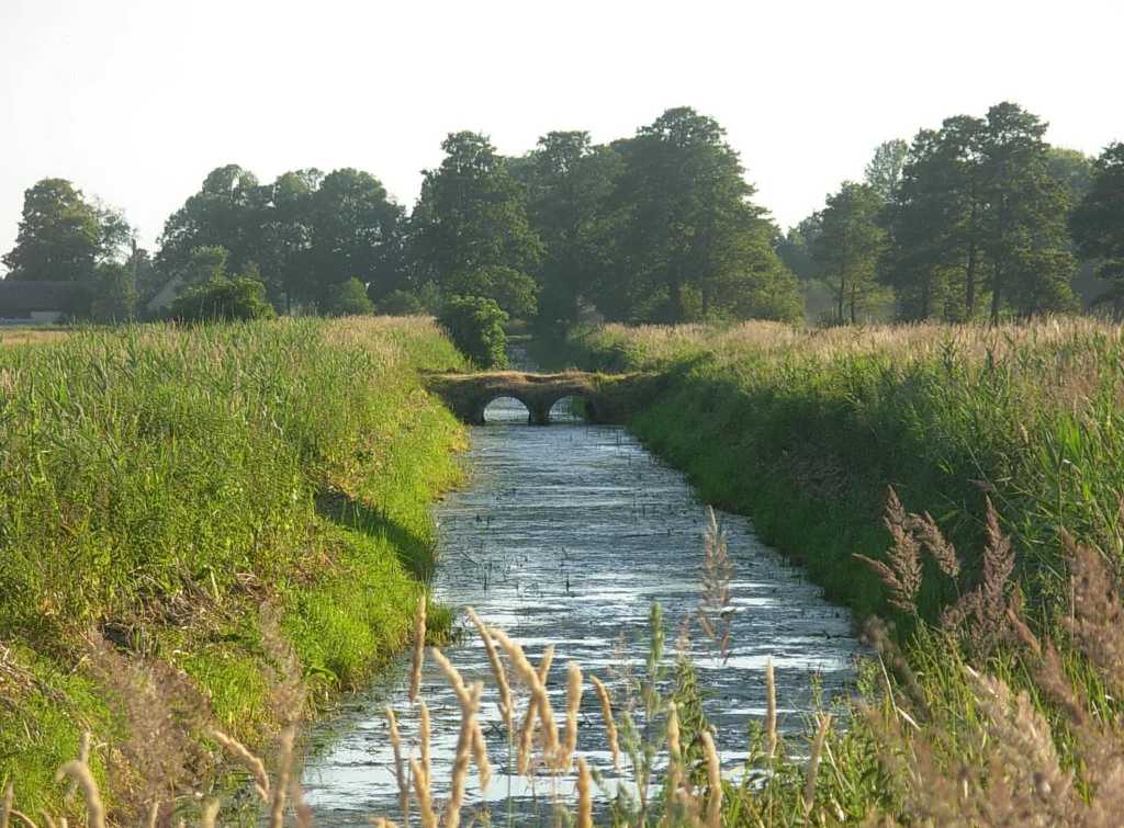
A narrow, straight canal cuts through green, grassy meadows leading toward a small stone bridge in the distance under a bright sky.
A narrow canal flowing through the Bydgoskie Łąki Nadnoteckie meadows in Dębinek.

Równina Szubińsko-Łabiszyńska ecosystems, habitats, and plant life

Ecologically, the site is built on peat and muck soils that have produced a habitat mosaic unusually rich for a lowland valley. Approximately three quarters of the area is covered by meadows and pastures, with the remaining share made up of deciduous and mixed forests on slightly elevated ground and a small proportion of arable land. Within the mosaic, small rises carry oak-hornbeam grądy woodlands, while sandy elevations support xerothermic vegetation typical of dry, warm habitats.

Protected habitats account for about eight percent of the area. The largest share belongs to variable-moisture _Molinetum_-type meadows, commonly known in Polish as Łąki Trzęślicowe ("quaking-grass meadows"), followed by oak-elm-ash ripianian floodplain forests (lasy łęgowe dębowo-wiązowo-jesionowe). These habitats are considered priorities under the EU Habitats Directive and form the foundation of the site's Natura 2000 status.

Wet meadows on peat, regulated canals, and small patches of dry sandy grassland all co-exist within the same protected landscape, giving Równina Szubińsko-Łabiszyńska a habitat gradient that spans from saturated organic substrates to xerothermic outcrops over very short distances.
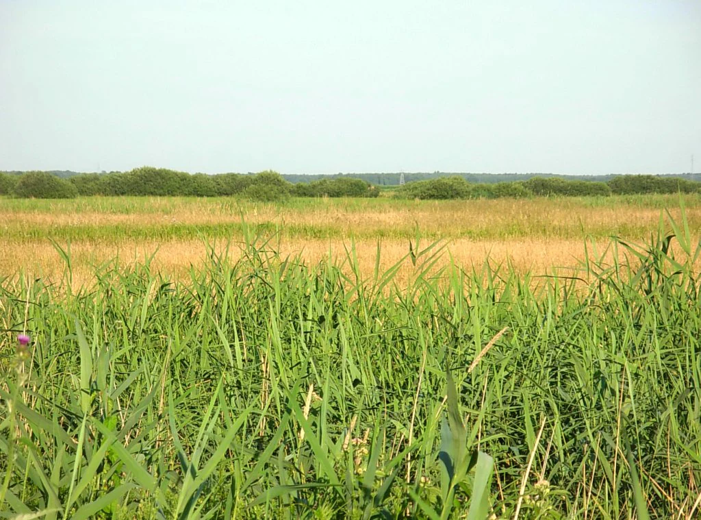
A wide view of flat, green and golden wetland meadows with a line of distant trees under a clear, pale sky.
The Bydgoskie Łąki Nadnoteckie meadows located in the Równina Szubińsko-Łabiszyńska region.

Równina Szubińsko-Łabiszyńska wildlife and species highlights

The wildlife interest of the area is most strongly expressed through its amphibian fauna and the plant species associated with its wet meadows. Several protected amphibian species are recorded, including the smooth newt (traszka zwyczajna) and a range of frogs: pool frog (Żaba jeziorkowa), moor frog (Żaba moczarowa), common frog (Żaba trawna), water frog (Żaba wodna), and the agile frog (Żaba śmieszka).

The meadows also harbour a number of characteristic and often protected vascular plants. Among those documented for the site are wild garlic (czosnek niedźwiedzi), mezereon (wawrzynek wilczełyko), the showy pink (gożdzik pyszny), and great burnet (krwiściąg lekarski). The combination of damp meadow conditions and scattered xerothermic patches creates room for both wet-loving and drought-tolerant species within a relatively confined geographic area.

As part of a broader national ecological corridor along the Noteć, the site also contributes to landscape-scale movement and dispersal of species typical of Polish lowland river valleys, even if its most distinctive faunal value lies in the amphibian and meadow-plant communities described above.
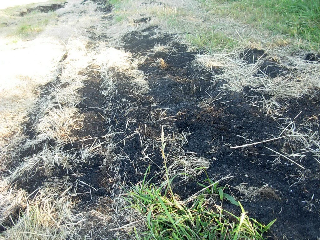
A close up of dark, exposed peat soil mixed with dry, yellowish grasses and patches of green vegetation.
A close view of peat soil in the Bydgoskie Łąki Nadnoteckie area within the Równina Szubińsko-Łabiszyńska region.

Równina Szubińsko-Łabiszyńska conservation status and protection priorities

Równina Szubińsko-Łabiszyńska is designated primarily for the conservation of natural habitats listed under the EU Habitats Directive, and the site is currently moving through the Natura 2000 process as a Site of Community Importance on its way to becoming a Special Area of Conservation. Its conservation value rests on the preservation of a representative, relatively intact fragment of the Noteć river-plain and on the protection of habitats that have become scarce in intensively used Polish lowlands.

Key protected habitats include variable-moisture wet meadows on peat soils and oak-elm-ash floodplain forests, the latter representing the type of deciduous floodplain woodland that has been lost or degraded across much of central Europe. The site is also notable because the single nature reserve within it, the Ostrów koło Pszczółczyna reserve, conserves an oak-hornbeam stand that includes large-leaved lime (lipa szerokolistna), a species of considerable botanical interest.

Beyond its own boundaries, the site is part of a broader conservation network: it borders the Obszar Chronionego Krajobrazu Łąk Nadnoteckich protected landscape area, the bird Special Protection Area Dolina Średniej Noteci i Kanału Bydgoskiego, and the Site of Community Importance Dolina Noteci. This positions the area as a national-scale ecological corridor between key protected sites along the Noteć river.

Top sights and standout views in Równina Szubińsko-Łabiszyńska

Standout features of Równina Szubińsko-Łabiszyńska include the extensive Bydgoskie Łąki Nadnoteckie meadows of the Noteć floodplain, the nineteenth-century Górnonotecki Canal and its dense network of regulating structures, and a rare-for-lowland mosaic where peat meadows, oak-elm-ash floodplain forests, oak-hornbeam woodlands, and xerothermic sandy vegetation all occur within a single Natura 2000 site.

The area is also notable for hosting the natural monument-rich Ostrów koło Pszczółczyna reserve, the diversity of protected amphibians in the Noteć valley, and the way the protected landscape ties together with neighbouring Natura 2000 sites and the Obszar Chronionego Krajobrazu Łąk Nadnoteckich to form an unusually coherent corridor of lowland habitat protection in north-central Poland.

Best time to visit Równina Szubińsko-Łabiszyńska

As a lowland river-plain nature area in central Poland, the landscape of Równina Szubińsko-Łabiszyńska changes most noticeably through the seasons in terms of visibility and atmosphere rather than accessibility. Late spring and early summer typically bring the richest display of meadow vegetation, including the flowering of characteristic species of wet grasslands.

Wet meadow and canal landscapes are generally more evocative in the warmer months, when water levels in the regulated canal network are easiest to observe and the open habitats are biologically most active. In winter, the flat meadows and canal infrastructure take on a quiet, open character and are easier to survey, though visitor-grade services and viewpoints are not the focus of this site.

Monthly climate preview

Long-term representative coordinate averages for temperature and monthly precipitation

Równina Szubińsko-Łabiszyńska Climate Normals and Annual Temperature Rhythms

Representative coordinate records show measured multi-year temperature swings and precipitation rates across twelve distinct monthly intervals. Examining the complete monthly climate profile reveals detailed thermal ranges and moisture patterns for Równina Szubińsko-Łabiszyńska.
Annual mean8 °C
-3 °C20 °C
Jan-3°
Feb-1°
Mar
Apr
May13°
Jun17°
Jul20°
Aug19°
Sep14°
Oct
Nov
Dec-1°
Warmest month
July

19.6 °C

Coolest month
January

-2.9 °C

Wettest month
July

2.6 mm/day

Driest month
April

1.2 mm/day

Park location guide

Geography guide, regional context, and park location map for Równina Szubińsko-Łabiszyńska

Równina Szubińsko-Łabiszyńska park geography, regions, and map view in Poland

Understand where Równina Szubińsko-Łabiszyńska sits in Poland through a broader geographic reading of the surrounding landscape, nearby location context, and its mapped position within the national park landscape.

How Równina Szubińsko-Łabiszyńska fits into Poland

Poland, officially the Republic of Poland, is a Central European country spanning from the Baltic Sea in the north to the Carpathian Mountains in the south. It borders Germany, Czech Republic, Slovakia, Ukraine, Belarus, Lithuania, and Kaliningrad Oblast. The country has a temperate climate, diverse landscapes, and is known for its rich history, cultural heritage, and strong economic position within the EU.

Wider geography shaping Równina Szubińsko-Łabiszyńska in Poland

Poland occupies 312,696 km2 in Central Europe, extending from the Baltic Sea coast in the north to the Sudetes and Carpathian Mountains in the south. It borders Germany to the west, Czech Republic and Slovakia to the south, Ukraine and Belarus to the east, and Lithuania and Kaliningrad Oblast to the northeast. The landscape includes lowland plains, uplands, and mountain ranges.

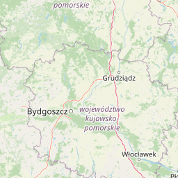
Map view of Równina Szubińsko-Łabiszyńska

Use this park location map to pinpoint Równina Szubińsko-Łabiszyńska in Poland, understand its exact geographic position, and read its mapped placement within the surrounding landscape more clearly.

Pigeon | © OpenStreetMap contributors

Location context for Równina Szubińsko-Łabiszyńska

Kuyavian-Pomeranian Voivodeship

Explore photographic records of wetland habitats, floodplain meadows, and protected lowland terrain.

Równina Szubińsko-Łabiszyńska Photos and Landscapes: Visualizing the Noteć River Valley

Visual documentation captures the flat river plain, peat meadows, and riparian forests that define the protected landscape. Examining these field photographs reveals the wetland habitats and canal infrastructure shaping the regional ecosystem.

A wide, panoramic view of a vast, flat meadow with green grass stretching to the horizon under a clear blue sky, with a dark tree shadow in the foreground right.

A close-up view of a metal manual sluice gate control wheel installed over a narrow, grassy drainage canal in a meadow landscape.

A narrow, straight canal cuts through green, grassy meadows leading toward a small stone bridge in the distance under a bright sky.

A wide view of flat, green and golden wetland meadows with a line of distant trees under a clear, pale sky.

A close up of dark, exposed peat soil mixed with dry, yellowish grasses and patches of green vegetation.

Park atlas

Compare regional river valleys, wetland corridors, and lowland habitats across the wider area

Parks Near Równina Szubińsko-Łabiszyńska and Surrounding Protected Landscapes

Browsing other protected areas near Równina Szubińsko-Łabiszyńska reveals shared lowland river corridors and peatland habitats. Comparing adjacent reserves helps trace regional ecological networks across the Noteć river valley.
Protected areaKujawsko-Pomorskie Voivodeship
16 km away#1 closest

Northeast

Solecka Dolina Wisły: Mapping the Middle Vistula River Valley Protected Landscapes

Protected riverine habitats in Kujawsko-Pomorskie Voivodeship

The Solecka Dolina Wisły protected area captures the ecological structure of the Vistula River valley. From active sandy bars in the river channel to oak-hornbeam woodlands on the upper valley slopes, the site offers a detailed look at lowland riverine geography, flood-plain dynamics, and xerothermic grassland habitats within the Polish landscape.

Area
70.301 km²
Established
2009
Relief
Lowland
Scope
Terrestrial
A horizontal watercolor painting depicting a soft, light-filled landscape with grassy fields, scattered shrubs, and a distant tree line across a low horizon, characterized by muted green, yellow, and pastel tones on a white background.
Nature reserveKuyavian-Pomeranian Voivodeship
About 18 km away#2 closest

Northwest

Jezioro Wieleckie Nature Reserve: Landscape and Geographic Overview of the Protected Bird Sanctuary

Ornithological wetland habitat in the Kuyavian-Pomeranian region

Located in the heart of the Kuyavian-Pomeranian Voivodeship, Jezioro Wieleckie Nature Reserve stands as an important faunal protected area. The reserve protects a water-focused landscape formed by glacial meltwater, supporting dense bird populations within its surrounding marshy grounds and forested rims. This atlas entry examines the physical boundaries and ecological features that define the site within the broader Krajeński Landscape Park.

Area
1.028 km²
Established
2005
Relief
Lowland
Scope
Terrestrial
Nature reserveKuyavian-Pomeranian Voivodeship
About 26 km away#3 closest

South

Rezerwat przyrody Mierucinek: Protected Oak Forest and Regional Landscape Context

A strictly protected reserve in the Kuyavian-Pomeranian Voivodeship

Explore the geographic footprint of Rezerwat przyrody Mierucinek, a 29.53-hectare nature reserve known for its mature oak forest community. This strictly protected area offers a clear look at the fertile deciduous woodland habitats characteristic of the Gniezno Lake District's undulating post-glacial landscape.

Area
0.295 km²
Established
1995
Relief
Lowland
Climate
Temperate
Watercolor painting of a wide, soft-focus river valley landscape with gentle hills, green vegetation, and a winding waterway.
Protected landscapeKuyavian-Pomeranian Voivodeship
33 km away#4 closest

Northeast

Chełmiński Park Krajobrazowy: Geographic Overview of Protected Lands in Kuyavian-Pomeranian

Glacial moraine terrain and Vistula valley protected landscapes

Chełmiński Park Krajobrazowy preserves a compact, high-contrast landscape where glacial moraine hills meet the active river corridors of the Lower Vistula. The area is defined by its five distinct nature reserves that safeguard unique slope habitats, island-like floodplain forests, and post-glacial lake basins, offering an essential reference for studying the geomorphology of the Polish lowlands.

Area
223.36 km²
Established
1998
Scope
Terrestrial
Water
Major water bodies
Protected areaKuyavian-Pomeranian Voivodeship
36 km away#5 closest

Northeast

Zbocza Płutowskie Protected Area: Ecological Geography and Habitat Mapping in Kuyavian-Pomeranian

A protected landscape featuring xerothermic slopes and riverine forest mosaics

Located in the Kuyavian-Pomeranian Voivodeship, Zbocza Płutowskie is a protected area preserving a mosaic of rare xerothermic grasslands and mature deciduous woodlands. The site showcases the importance of lowland habitat connectivity, including oak-hornbeam communities and riparian forests, offering a detailed perspective on regional ecological terrain.

Area
10.114 km²
Relief
Lowland
Climate
Temperate
Access
Access unknown
Nature reservePoland
About 39 km away#6 closest

South

Mięcierzyn Nature Reserve: Geographic Overview and Protected Forest Landscape Boundaries

A rare lowland beech forest sanctuary in Poland's Gnieźno Lakeland

Mięcierzyn Nature Reserve stands as a protected enclave within the Gołąbki Forest District, exemplifying fertile lowland beech woodland ecology. This compact site offers deep insights into forest composition on non-calcareous soils, representing a distinct geographic feature within the rolling moraine terrain of north-central Poland.

Area
0.532 km²
Established
1996
Relief
Lowland
Climate
Temperate
Nature reserveGreater Poland Voivodeship
40 km away#7 closest

Northwest

Uroczyska Kujańskie Nature Reserve: A Geographic Overview of the Krajeńskie Lakeland

Mapped protected landscapes, glacial lakes, and old-growth oak forests.

Uroczyska Kujańskie provides a rare study in post-glacial landscape architecture. Situated in the Greater Poland Voivodeship, this site links dystrophic lakes, travertine-forming spring fens, and extensive acid oak forests. Use our atlas data to understand the complex ecological boundaries and hydrological features that define this protected Natura 2000 habitat.

Area
10.182 km²
Relief
Lowland
Scope
Terrestrial
Water
Major water bodies
Nature reserveKuyavian-Pomeranian Voivodeship
About 43 km away#8 closest

Northwest

Rezerwat przyrody Dęby Krajeńskie: Mapping Forest Biodiversity and Protected Land

Nature reserve geography in Kuyavian-Pomeranian Voivodeship

Dęby Krajeńskie stands as a significant lowland woodland reserve featuring old-growth oak and beech stands. Located within the Krajeński Landscape Park, it represents a core protected area for regional avian populations and spring-flowering forest herbs. Explore the terrain characteristics and ecological significance of this preserved Polish woodland environment.

Area
0.458 km²
Established
2001
Relief
Lowland
Scope
Terrestrial

Common questions about visiting, size, designation, and location context for Równina Szubińsko-Łabiszyńska

Równina Szubińsko-Łabiszyńska FAQs for park facts, access, geography, and protected area context

Find quick answers about Równina Szubińsko-Łabiszyńska, including protected-area facts, park geography, trail and visitor context, and how the park fits into its surrounding country and regional landscape.
MoriAtlas Explorer

Continue Your Protected Areas Search Across the Global Atlas

Deepen your exploration by continuing the structured search for national parks and protected areas worldwide. Utilize the comprehensive filtering capabilities to compare different conservation landscapes and refine your understanding of global park geography. Discover more about the distribution and characteristics of protected natural areas.

Global natural geography