
Why Ruppertsklamm stands out
Ruppertsklamm is best known for being a sharply incised, narrow forested gorge in the Niederwesterwald, where a small Lahn tributary descends roughly 235 meters over only about 1.2 kilometers. The steep rock walls, moss-covered boulders, and closely interwoven stream crossings give it a particularly intimate and sheltered character despite its small size. The reserve is also notable for its species-rich deciduous woodland, its long-standing protected status dating back to 1936, and its integration into larger European conservation networks that protect the Lahn valley slopes.
Ruppertsklamm history and protected-area timeline
The Ruppertsklamm was first made publicly accessible between 1910 and 1912, when Theodor Zais, a railway telegraphist and nature enthusiast, developed a walking trail along the gorge for local hikers. A memorial plaque placed halfway up the path commemorates his work. The name "Ruppertsklamm" itself appeared only relatively late: until around 1901 the stream was known as Michelsbach and the valley had no distinct name, but a 1901 Prussian survey map sheet labeled "Coblenz" recorded the valley as "Ruppertsthal," likely the result of a mapping error that nonetheless became the accepted name.
Formal protection followed decades later. In 1936 the area was officially designated as the Naturschutzgebiet Ruppertsklamm, placing one of the earliest layers of modern conservation over a landscape that had already become well known to local walkers. Since then the gorge has remained continuously protected, and its status has been reinforced through inclusion in European-level conservation networks.
Over the twentieth and early twenty-first centuries the Ruppertsklamm continued to function as a traditional hiking destination in the Lahn valley, eventually joined by the long-distance Rheinsteig and Lahnwanderweg trails, which formalized its place within regional hiking infrastructure.
Ruppertsklamm landscape and geographic character
The Ruppertsklamm is shaped by an unusually steep profile compressed into a short horizontal distance. The gorge runs for roughly 1.2 kilometers along a small right-bank tributary of the Lahn, with a total elevation difference of about 235 meters between the lower and upper ends. This rapid descent keeps the slopes extremely steep and produces the narrow, tightly enclosed valley form that defines the reserve.
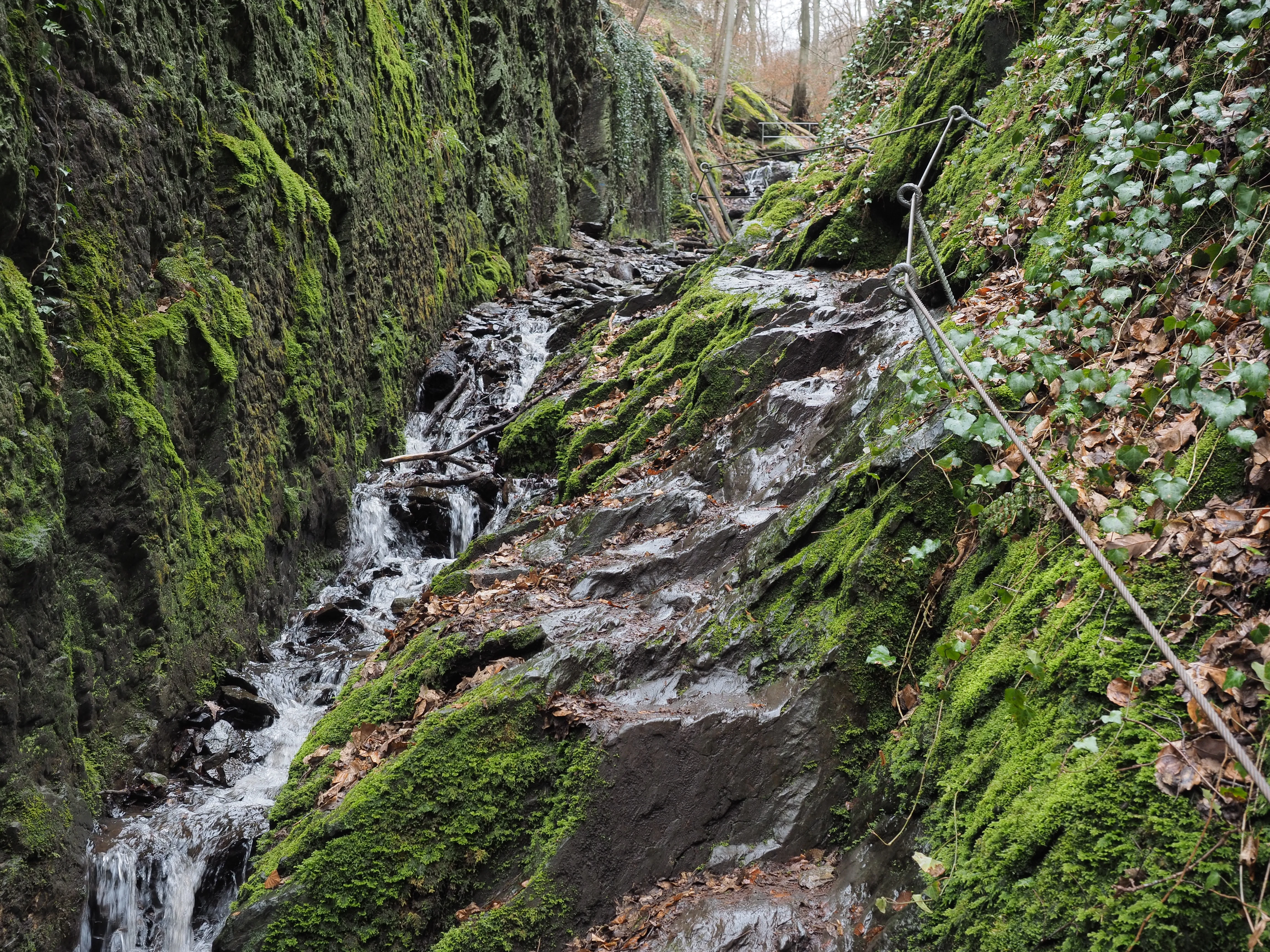
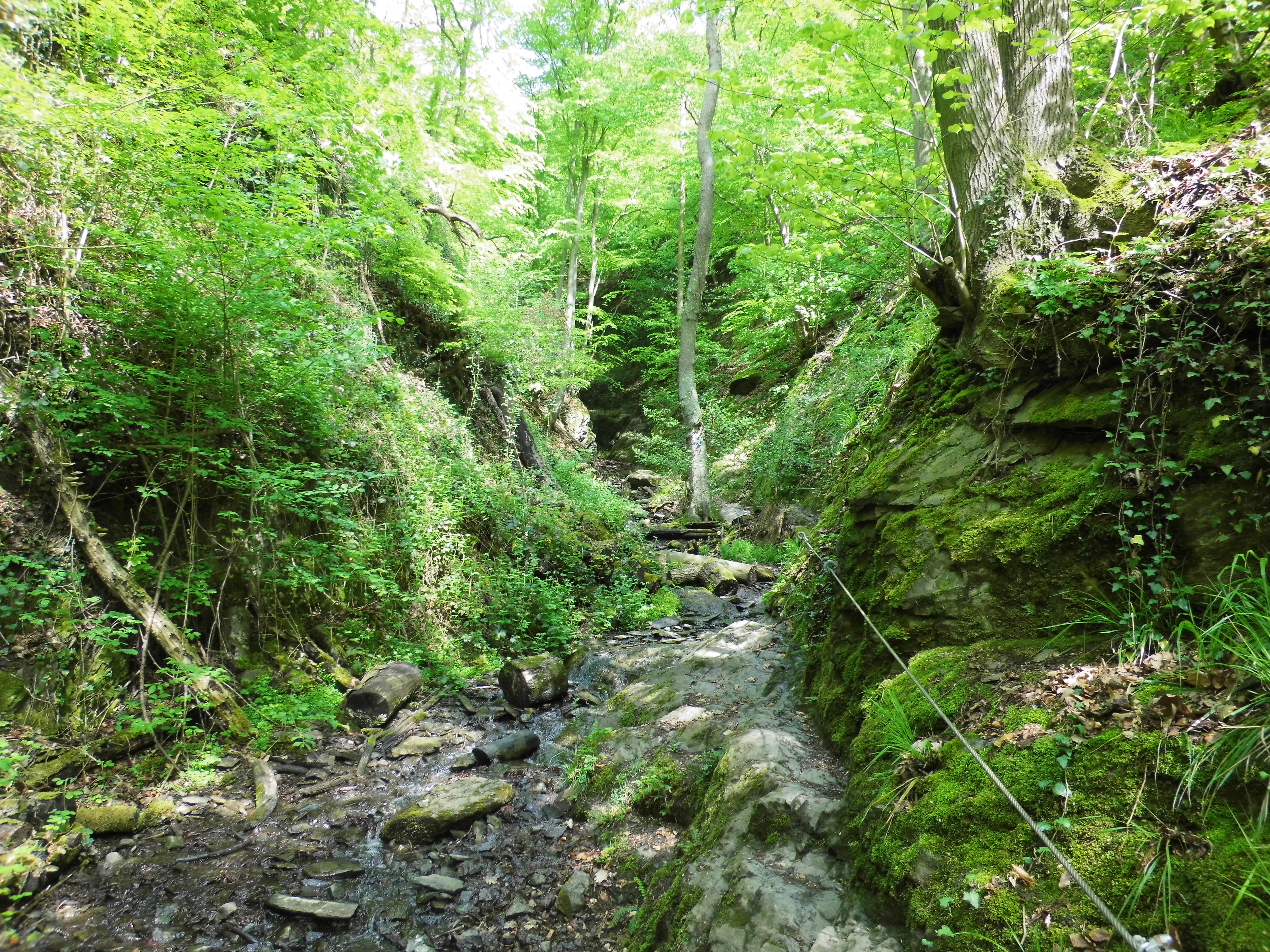
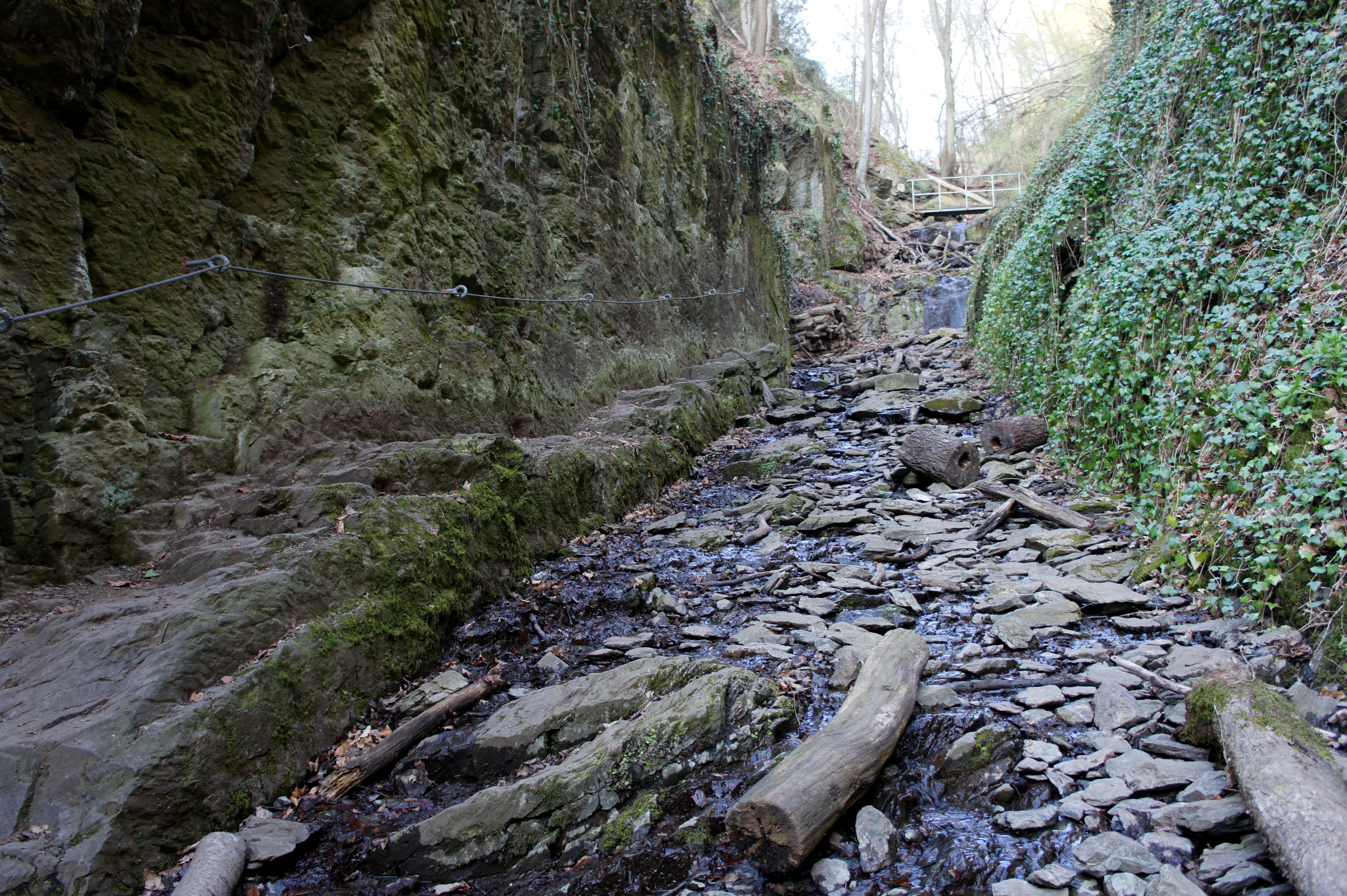
In the lower section, near the mouth of the gorge at the B 260 toward Bad Ems, the terrain opens slightly where the former Hohenrheiner Hütte once stood. From here the trail climbs quickly into the narrower, steeper middle reaches, where vertical rock walls rise directly from the streambed and natural steps have been cut into the stone for safer passage, supplemented by steel cable handholds.
Water is the defining visual thread of the gorge. The small stream threads over and between mossy boulders through tight bends, with pools and small cascades forming wherever the bedrock steps downward. Nine small bridges and footbridges span the water, along with a sequence of fords marked by stepping stones that together produce a characteristic pattern of continuous cross-over of the brook.
Ruppertsklamm ecosystems, habitats, and plant life
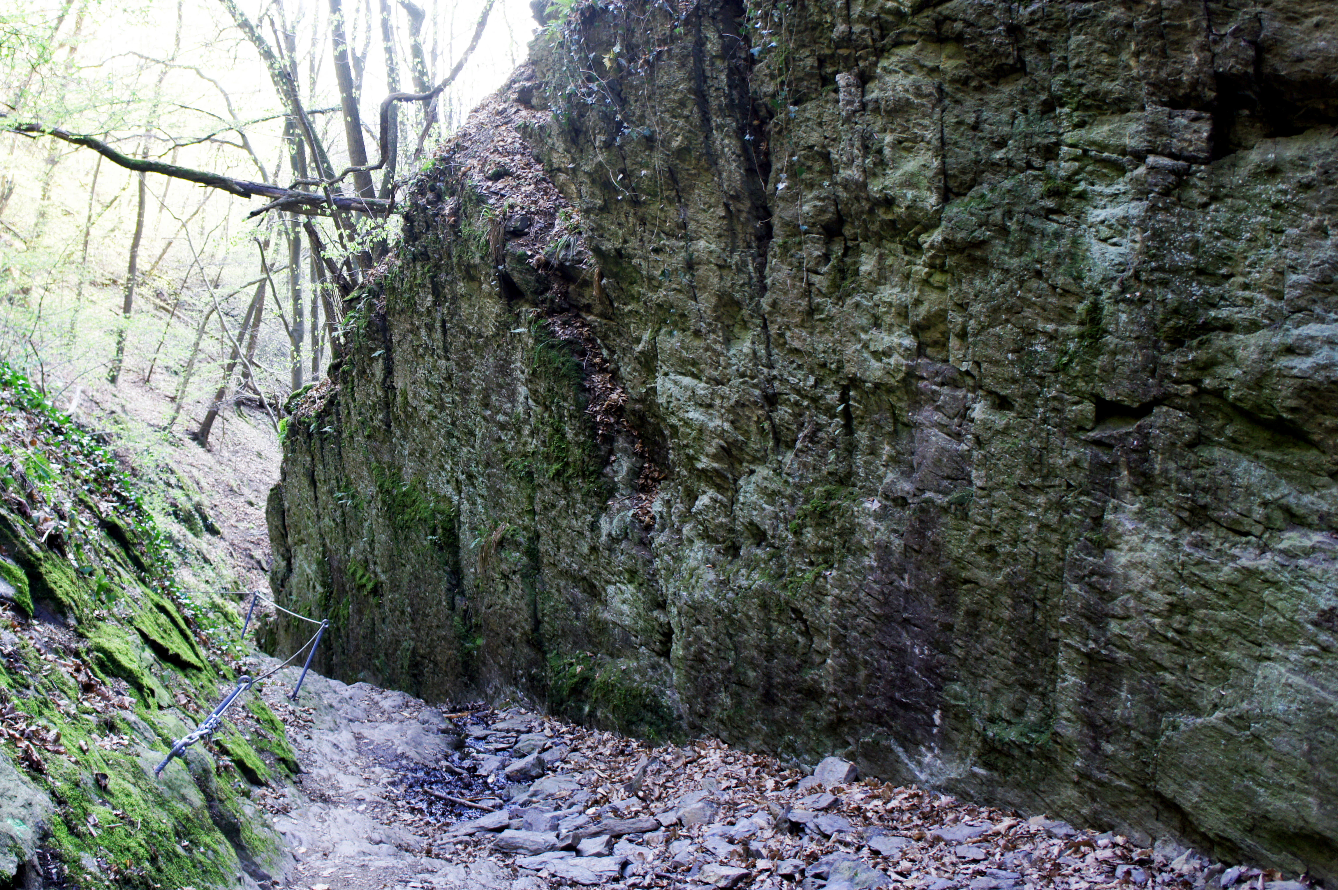
The Ruppertsklamm is dominated by species-rich deciduous woodland typical of the Lahn and lower Westerwald slopes. The canopy and understory close in tightly over the narrow valley, creating a shaded, humid microclimate that supports mosses, ferns, and moisture-loving herbaceous plants along the stream margins and rock bases.
The combination of steep rocky walls, deep shaded clefts, and continuous stream moisture gives the gorge a layered habitat structure. Open rock outcrops, boulder fields, damp leaf litter along the brook, and the more gently sloping forest edges near the entrances each support different plant communities, which contributes to the reserve's recognized ecological value despite its small footprint.
Because the gorge falls within the Natura 2000 Birds Directive area Lahnhänge, woodland and cliff habitats here are also managed as part of broader landscape-level conservation for forest and slope species in the Lahn valley.
Ruppertsklamm wildlife and species highlights
The forested slopes and rocky cliffs of the Ruppertsklamm provide habitat for the woodland and slope-associated bird communities typical of the Lahn valley, which is exactly why the surrounding area is designated under the European Birds Directive. The combination of mature deciduous forest, vertical rock faces, and a shaded stream corridor supports nesting and foraging habitat for typical forest and cliff-nesting bird species of the region.
Cool, humid conditions along the stream and under the dense canopy also favor moisture-dependent invertebrates and amphibians, while the broader deciduous forest above the gorge hosts the usual range of small woodland mammals associated with mixed broadleaf forest in the lower Westerwald.
Because the gorge is embedded within the larger Lahnhänge Natura 2000 complex, the wildlife value of the Ruppertsklamm is best understood as a contribution to a wider protected corridor along the Lahn valley rather than as a standalone fauna hotspot.
Ruppertsklamm conservation status and protection priorities
Ruppertsklamm has been protected as a Naturschutzgebiet since 1936, giving it one of the longest continuous conservation histories in the Rhein-Lahn-Kreis. At about 14.83 hectares it is small in absolute terms, but its legal protection has been in place for nearly ninety years, providing long-term stability for its deciduous woodland and gorge habitats.
The reserve is fully integrated into the European Natura 2000 network. It lies within the Special Protection Area Lahnhänge (DE-5611-401) under the Birds Directive and within the Site of Community Importance Lahnhänge (DE-5613-301) under the Habitats Directive. This means that, in addition to German nature reserve protections, the gorge benefits from the habitat and species protections of the wider European conservation framework.
The gorge is also part of the UNESCO World Heritage cultural landscape of the Upper Middle Rhine Valley, which frames the Ruppertsklamm as a natural-area component of a broader landscape of recognized universal value.
Ruppertsklamm cultural meaning and human context
The Ruppertsklamm has a long-standing identity as a place for local walking and nature appreciation. Its trail network was developed by Theodor Zais in the years around 1910-1912, and a commemorative plaque along the path still marks his contribution, reflecting the early tradition of citizen stewardship of natural areas in this part of western Germany.
The upper shelter near the top of the gorge, with seating for roughly 50 people and an open fireplace, is a typical feature of regional hiking culture in the Lahn and Westerwald hills, where open forest huts serve as informal gathering places for self-catering visitors. The presence of both the Rheinsteig and the Lahnwanderweg long-distance trails passing through the reserve places the Ruppertsklamm within a wider regional hiking heritage that connects the Lahn valley with the Rhine valley.
The gorge also lies within the UNESCO-listed Upper Middle Rhine Valley cultural landscape, linking its natural environment with centuries of settlement, transport, and tourism history along one of Europe's iconic river corridors.
Top sights and standout views in Ruppertsklamm
The defining qualities of the Ruppertsklamm include its tight, steep gorge profile; its dense, species-rich deciduous forest; and its unusually compact scale, which packs a 235-meter elevation change into about 1.2 kilometers of trail. The combination of mossy rock walls, a continuously crossing stream, and multiple small bridges and stepping-stone fords gives the walk a strong sense of intimacy with the landscape.
Equally distinctive is the layering of protection around the site: long-standing German nature reserve status from 1936, full inclusion in the European Natura 2000 network through the Lahnhänge bird and habitat sites, and a position within the UNESCO Upper Middle Rhine Valley World Heritage cultural landscape.
Best time to visit Ruppertsklamm
The Ruppertsklamm can be visited year-round, but the experience shifts significantly with the seasons. Spring brings fresh green foliage to the deciduous canopy and higher flow rates in the small stream, which makes the cascades and pools along the gorge more visually active. Summer offers dense, fully leafed-out forest cover and strongly shaded conditions in the middle gorge, though the narrow rocky sections can feel muggy on hot days.
Autumn is typically the most scenically varied period, with leaf color change across the broadleaf forest and generally drier, more stable footing along the rocky sections. In winter, sparse foliage opens up views of the rock walls and the stream, and snow or frost can make the steel-secured sections of the trail require extra caution, while the open upper hut becomes a more exposed spot for breaks.