

Mori Atlas logo
Nature reserveSainte Luce Reserve

A concentrated protected area featuring rare littoral forest, ebony enclaves, and river-influenced mangroves.

Sainte Luce Reserve: Mapping the Coastal Rainforest and Protected Landscapes of Madagascar

Sainte Luce Reserve functions as a critical protected fragment along the southeastern coast of Madagascar, preserving one of the last intact coastal rainforest corridors in the region. Spanning a narrow strip between the Indian Ocean and interior landscapes, the reserve encompasses distinct vegetation zones including Pandanus-dominated forest, white-sand ebony groves, and complex mangrove habitats. This area provides essential refuge for endemic lemur populations and rare botanical species, serving as a focal point for regional biodiversity within the broader Madagascar geography.

coastal rainforestlittoral forestlemursprivate reserveendemic speciesebony forest

Sainte Luce Reserve

Nature reserve

Park overview

Structured park overview, official facts, and landscape profile for Sainte Luce Reserve

Sainte Luce Reserve park facts, protected area profile, and essential visitor context

Review the core facts for Sainte Luce Reserve, including designation, size, terrain, visitor scale, habitats, and operating context in one park-focused overview.

About Sainte Luce Reserve

Sainte Luce Reserve sits on Madagascar's southeastern coast, a region where the southeastern littoral forests have historically been one of the most biodiversity-rich and most threatened habitats on the island. The reserve protects a small but exceptionally important section of this coastal forest ecosystem, near the village of Manafiafy in the Mahatalaky municipality and not far from the regional center of Tolagnaro, also known as Fort-Dauphin.

The reserve's defining feature is its position within a Pandanus-dominated coastal rainforest, a habitat type that combines humid forest with the influence of nearby rivers and the Indian Ocean coastline. Embedded within this forest are enclaves of white-sand ebony forest, where rare Diospyros trees grow in unusual soil conditions, and patches of river mangrove that line the waterways cutting through the landscape. Together these habitats create a mosaic of vegetation types compressed into a narrow strip between the coast and the interior.

Sainte Luce Reserve is privately managed by the Filana Association, a nonprofit that has overseen the site since 2010. Its conservation work is closely tied to research on local wildlife, especially the lemurs that inhabit the forest. The reserve regularly hosts volunteers and researchers who contribute to lemur studies, sea turtle monitoring, seed collection, tree planting, and community engagement with neighboring villages. Through these activities, the reserve has become a focal point for grassroots conservation in a region where habitat fragmentation and resource extraction continue to threaten the surrounding forests.

Quick facts and research context for Sainte Luce Reserve

Sainte Luce Reserve is a privately managed nature reserve on the southeastern coast of Madagascar, located in the municipality of Mahatalaky near the village of Manafiafy. It lies within the larger Sainte Luce rainforest, a narrow coastal forest corridor roughly 15 kilometers long and between 100 and 700 meters wide. The reserve itself covers a much smaller footprint of about one kilometer in length.

The reserve is governed by the Filana Association, a nonprofit organization that depends significantly on volunteer involvement. It is a member of the Lemur Conservation Network and has been recognized as a key site for protecting endemic lemurs, rare palms, and one of the last intact coastal rainforest stretches in southern Madagascar. Its ecosystems include Pandanus-dominated littoral rainforest, white-sand ebony enclaves, and river mangroves.

Protection and recognition

Documented terrestrial protection scope and management parameters

Sainte Luce Reserve Protection Status and International Recognition

Records for Sainte Luce Reserve outline the documented terrestrial protection scope, management framework, and recognized conservation boundaries. Verified administrative entries provide structured facts regarding international status without assuming specific governance outcomes.

Protection details

Protection scope
Terrestrial
Transboundary protection
No
Park context

Deeper park guide and search-rich context for Sainte Luce Reserve

Sainte Luce Reserve history, landscape, wildlife, and travel context

Explore Sainte Luce Reserve through its history, landscape character, ecosystems, wildlife, conservation priorities, cultural context, and seasonal travel timing in a structured park guide built for atlas discovery and search intent.

Why Sainte Luce Reserve stands out

Sainte Luce Reserve is best known for protecting a fragment of one of Madagascar's last intact coastal rainforests, with an exceptionally high density of endemic species packed into a very small area. The reserve is particularly associated with lemurs, including the Collared brown lemur, the Sainte Luce mouse lemur, and other nocturnal species such as the fat-tailed dwarf lemur and Southern woolly lemur. It is also distinguished by its rare ebony forest enclaves growing on white sand and its population of the endangered palm Dypsis saintelucei, one of only four known locations for this species in Madagascar. The reserve's combination of Pandanus rainforest, ebony stands, and river mangroves along a narrow coastal strip gives it an unusually rich ecological profile for its size.
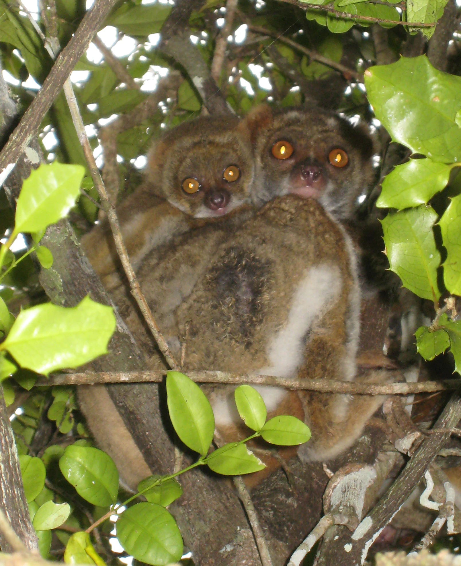
A close-up view of two lemurs, an adult and an infant, nestled together in a tree with green leaves.
A Southern Wooly Lemur and its infant perched in the foliage of Sainte Luce Reserve.

Sainte Luce Reserve history and protected-area timeline

Sainte Luce Reserve was formally established in 2009 as a private protected area dedicated to conserving a small but ecologically vital fragment of southeastern Madagascar's coastal rainforest. Management of the site was taken up by the Filana Association beginning in 2010, establishing the nonprofit framework that continues to govern the reserve today.

The Collared brown lemur, one of the reserve's signature species, was first recorded at the site in 1990, drawing early scientific attention to the area's unique primate population. Over time, the reserve grew in importance as researchers identified additional species of conservation concern in the surrounding forests, including the mouse lemur now associated with Sainte Luce and the rare palm Dypsis saintelucei. Its later membership in the Lemur Conservation Network connected these local efforts to international primate conservation initiatives.

The reserve's development has also been shaped by the broader pressures affecting the region's littoral forests, including deforestation driven by shifting agriculture and the impacts of mining activity near Tolagnaro. In response, the Filana Association has built a conservation model that combines scientific research, direct habitat work, and community outreach, reflecting the recognition that protecting such a small forest fragment requires engagement with the surrounding human landscape as well as the wildlife within it.

Sainte Luce Reserve landscape and geographic character

The landscape of Sainte Luce Reserve is defined by its position along Madagascar's southeastern coast, where a narrow band of rainforest runs between the Indian Ocean and the interior. The broader Sainte Luce rainforest extends roughly 15 kilometers along the coast, varying in width from about 100 to 700 meters, while the reserve itself is a roughly one-kilometer-long section averaging around 300 meters across. This linear geography means the forest feels intimate and concentrated, with relatively short distances between very different microhabitats.

The terrain supports three visually distinct vegetation zones. The dominant matrix is a Pandanus-dominated coastal rainforest, characterized by screw pines and a humid, dense canopy typical of Madagascar's southeastern littoral forests. Within this matrix lie enclaves of rare ebony forest, where Diospyros trees grow on white sandy soils, creating a striking contrast of pale ground and dark hardwood trunks. Along the rivers that cut through the forest, mangrove vegetation establishes a third habitat type, linking freshwater flow to coastal conditions.

The surrounding region has been shaped by both natural and human pressures. Forests in the wider Tolagnaro area have been affected by slash-and-burn agriculture, locally known as tavy, and by mining for titanium-rich sands, including ilmenite deposits. These pressures on adjacent forest areas heighten the importance of the reserve's protected coastal strip as a refuge for the landscape's characteristic vegetation patterns.

Sainte Luce Reserve ecosystems, habitats, and plant life

Sainte Luce Reserve protects a compressed but exceptionally rich ecological system within Madagascar's southeastern littoral forests. The dominant habitat is a Pandanus-dominated coastal rainforest, a vegetation type restricted in range and heavily impacted elsewhere by deforestation. The reserve also includes pockets of white-sand ebony forest and river mangrove, giving it a layered ecological structure where rainforest, specialized sandy soils, and riparian vegetation all coexist.

Ecologically, the reserve is significant for the high proportion of species endemic to Madagascar, particularly within its plant communities and invertebrate fauna. Studies have documented a large diversity of land snails, with nearly all species found here being endemic to Madagascar. The forests also support roughly 200 tree species, much of the reptile and bird diversity of the area, and a striking concentration of primate species confined to a small stretch of coastal habitat. The presence of multiple vegetation types on a single narrow landscape creates strong ecological gradients over very short distances.

Sainte Luce Reserve wildlife and species highlights

The wildlife of Sainte Luce Reserve is shaped strongly by its primate fauna, particularly its lemurs. The reserve is home to five lemur species, including the Collared brown lemur, which was first recorded here in 1990 and is otherwise restricted to this part of Madagascar. The Sainte Luce reserve also shelters the Sainte Luce mouse lemur, a small primate believed by some researchers to represent an unclassified species distinct from neighboring populations because the reserve's forest is separated from other Sainte Luce forests by rivers.

Other nocturnal lemurs found in the reserve include the fat-tailed dwarf lemur and the Southern woolly lemur, the latter also known as the southern avahi. Beyond the primates, the reserve supports at least 50 reptile species, roughly 50 bird species, and an exceptionally high diversity of land snails, around 98 percent of which are endemic to Madagascar. Sea turtles in the surrounding waters are also part of the reserve's monitoring focus, extending its wildlife work from the forest into the coastal zone.

One of the reserve's most distinctive wildlife stories involves the endangered palm Dypsis saintelucei, which is found in only four locations in Madagascar and of which only about 300 mature individuals survive globally. The palm's habitat at Sainte Luce overlaps with both traditional lobster trap construction and ongoing ilmenite mining, placing this rare species at the center of local conservation concerns.

Sainte Luce Reserve conservation status and protection priorities

Sainte Luce Reserve is significant from a conservation standpoint because it safeguards a small but ecologically irreplaceable fragment of Madagascar's southeastern littoral rainforest, a habitat that has been heavily reduced by deforestation and mining across the region. Its protected status, combined with its position within one of the last intact coastal forest corridors, makes it an important refuge for endemic species that survive in few other locations.

The reserve is a member of the Lemur Conservation Network, situating its work within broader efforts to protect Madagascar's highly threatened lemur fauna. The Collared brown lemur, found at Sainte Luce and only in this part of Madagascar, is a focus species, as is the local mouse lemur population, which may represent an unrecognized species isolated by rivers from neighboring forests.

Conservation at Sainte Luce is conducted largely through the Filana Association, a small nonprofit that depends on volunteer support. Activities include lemur research, sea turtle monitoring, seed collection for native trees, reforestation through planting, and outreach to surrounding communities. This combination of scientific work, habitat restoration, and community engagement reflects the recognition that protecting such a small forest requires integrated action across the broader landscape.

Top sights and standout views in Sainte Luce Reserve

Sainte Luce Reserve offers an unusually concentrated experience of Madagascar's southeastern littoral biodiversity within a very small protected footprint. One of its most compelling features is the presence of five lemur species, including the Collared brown lemur whose global range is essentially tied to this area, and a mouse lemur population of uncertain classification that may be unique to the reserve.

The reserve also stands out for its rare plant life, from white-sand ebony enclaves to the endangered Dypsis saintelucei palm, of which only around 300 mature individuals survive in just four locations across Madagascar. Combined with mangrove-lined rivers, Pandanus-dominated rainforest, sea turtle monitoring along the coast, and a volunteer-driven nonprofit management model, the reserve represents an intensive example of how a small site can carry an outsized share of regional conservation responsibility.

Best time to visit Sainte Luce Reserve

Because Sainte Luce Reserve is a small coastal rainforest reserve in southeastern Madagascar, its character shifts with the broader climatic rhythm of the region, alternating between warmer, wetter periods and cooler, drier months. The wetter months tend to bring lusher vegetation, denser forest conditions, and more challenging ground underfoot, while the drier periods often feature more comfortable temperatures and easier walking conditions for exploring the narrow forest strip and its river and mangrove margins.

Wildlife viewing, particularly of lemurs and reptiles, can be productive throughout much of the year, though cooler, drier months are often associated with more active primate movement and easier observation along trails. Sea turtle monitoring and forest restoration activities continue seasonally, meaning the reserve's conservation rhythms offer their own sense of timing for visitors interested in volunteering or research-based visits. As with any coastal Madagascar site, weather patterns near the Indian Ocean can shift quickly, and conditions are best understood as broadly seasonal rather than rigidly predictable.
Monthly climate preview

Long-term monthly averages for temperature and precipitation rhythms in Madagascar

Sainte Luce Reserve Climate Normals and Annual Temperature Patterns

Historical coordinate data records measured monthly temperature ranges and precipitation rates for Sainte Luce Reserve from 1991 to 2020. Examining the complete twelve-month climatology profile reveals comprehensive annual meteorological trends across the protected landscape.
Annual mean23 °C
19 °C25 °C
Jan25°
Feb25°
Mar25°
Apr23°
May21°
Jun20°
Jul19°
Aug20°
Sep21°
Oct23°
Nov24°
Dec25°
Warmest month
January

25.3 °C

Coolest month
July

19.2 °C

Wettest month
February

7 mm/day

Driest month
September

1.4 mm/day

Park location guide

Geography guide, regional context, and park location map for Sainte Luce Reserve

Sainte Luce Reserve park geography, regions, and map view in Madagascar

Understand where Sainte Luce Reserve sits in Madagascar through a broader geographic reading of the surrounding landscape, nearby location context, and its mapped position within the national park landscape.

How Sainte Luce Reserve fits into Madagascar

Madagascar is an island nation in the Indian Ocean, positioned off the southeastern coast of Africa. As the world's fourth-largest island and second-largest island country, it stands out for its exceptional biodiversity, over 90% of its wildlife is endemic, making it one of 17 megadiverse countries. The population is approximately 32 million, with Antananarivo as both the capital and largest city.

Wider geography shaping Sainte Luce Reserve in Madagascar

Madagascar lies in the Indian Ocean off the southeastern coast of Africa, separated from the mainland by the Mozambique Channel. The island is situated approximately 400 km from the African continent. As the world's fourth-largest island, it also includes numerous smaller peripheral islands.

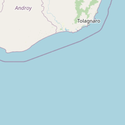
Map view of Sainte Luce Reserve

Use this park location map to pinpoint Sainte Luce Reserve in Madagascar, understand its exact geographic position, and read its mapped placement within the surrounding landscape more clearly.

Pigeon | © OpenStreetMap contributors

Explore the visual scenery, littoral habitats, and protected forest terrain of Madagascar

Sainte Luce Reserve Photos and Coastal Rainforest Landscapes

Visual documentation captures the dense canopy, rare white-sand ebony enclaves, and river mangroves defining the narrow coastal strip of Madagascar. Examining these protected habitats provides a deeper understanding of the distinct microhabitats and endemic wildlife sheltered within the reserve.

A close-up view of two lemurs, an adult and an infant, nestled together in a tree with green leaves.

Park atlas

Compare regional coastal rainforests and surrounding protected habitats

Parks Near Sainte Luce Reserve and Connected Protected Landscapes

Browse protected areas near Sainte Luce Reserve to examine related coastal rainforest corridors and rare lowland habitats across the wider regional geography. Expanding the search helps connect isolated littoral reserves with larger conservation landscapes throughout southeastern Madagascar.
Nature reserveAnosy
About 20 km away#1 closest

Northwest

Tsitongambarika Nature Reserve: Geographic Profile and Protected Forest Landscape

Lowland humid evergreen forest in the Anosy region

Tsitongambarika represents one of the final remaining lowland humid evergreen forest tracts in southern Madagascar. The reserve encompasses an extensive massif of ridges and the isolated Mount Ivohibe, supporting complex drainage networks that sustain the coastal water supply of the Anosy region. This protected landscape is fundamental for preserving regional biodiversity, including endemic lemurs, palm species, and specialized forest bird habitats across the southeastern Madagascar terrain.

Area
585.97 km²
Established
2015
IUCN
VI
Relief
Mountain
Nature reserveMadagascar
About 24 km away#2 closest

Southwest

Mandena Conservation Zone: Protected Littoral Forest and Wetland Geography in Madagascar

A critical nature reserve near the southeastern coastline

Mandena Conservation Zone protects over 200 hectares of rare littoral forest and coastal swamp in southeastern Madagascar. As one of the few remaining fragments of this unique coastal ecosystem, the reserve provides a critical habitat for endemic lemur populations and serves as an important site for understanding the regional geography of the Tolagnaro area.

Area
2.3 km²
Relief
Lowland
Climate
Tropical
Access
Access unknown
National parkMadagascar
About 52 km away#3 closest

Northwest

Andohahela National Park: Protected Landscape and Geographic Atlas Context in Madagascar

Explore the mapped terrain and regional park geography.

Understand Andohahela National Park as a distinct national park entity, focusing on its geographic setting and protected landscape characteristics within Madagascar. This detail page provides structured data on the park's mapped boundaries and its regional importance, offering insights for anyone exploring protected areas and natural terrain through a geographic lens. It is an essential resource for understanding the park's specific context in the broader atlas.

Area
760 km²
Established
1998
IUCN
II
Visitors
1.3K annual
Wildlife reserveAnosy
About 90 km away#4 closest

West

Berenty Reserve Wildlife Reserve in the Anosy Region of Southern Madagascar

Spiny forest ecology and riverine landscape mapping

Berenty Reserve offers a concentrated look at the semi-arid spiny forests of southern Madagascar. This wildlife reserve, located along the Mandrare River in the Anosy region, serves as a vital protected area for observing endemic species within a striking terrain of cactus-like plants, baobabs, and thorny thickets.

Relief
Lowland
Climate
Arid
Access
Moderate access
Scope
Terrestrial
National parkAtsimo-Atsinanana
About 146 km away#5 closest

North

Midongy du sud National Park: National Park in Atsimo-Atsinanana, Madagascar

Explore its protected landscape and mapped geography.

Midongy du sud National Park is a significant protected area located in the Atsimo-Atsinanana region of Madagascar. This entry provides detailed geographic context, focusing on the park's mapped boundaries and its identity as a national park. It supports atlas-based discovery by offering insights into the park's specific landscape and its regional setting within southeastern Madagascar, serving as a factual resource for understanding its protected status.

Area
1,922 km²
Established
1997
IUCN
II
Relief
Mountain
Wildlife reserveMadagascar
About 163 km away#6 closest

Northwest

Kalambatritra Special Reserve: Exploring the Geography of Southern Madagascar Protected Lands

Mapping a unique humid highland forest refuge

The Kalambatritra Special Reserve comprises a significant forested block in southern Madagascar, defined by ridges and valleys that maintain a humid microclimate. This protected area serves as a critical habitat for endemic wildlife, bridging the gap between eastern forest ecosystems and the drier terrain of the southern plateau, providing an essential study in island geography and conservation.

Area
282.55 km²
Established
1959
IUCN
IV
Scope
Terrestrial
Wildlife reserveAndroy
About 219 km away#7 closest

Southwest

Réserve spéciale du Cap Sainte-Marie: Wildlife Reserve and Protected Coastal Landscape in Androy

An essential arid-zone habitat at the southernmost edge of Madagascar

Réserve spéciale du Cap Sainte-Marie protects a fragile ecosystem of spiny thicket and coastal terrain. As a focal point for tortoise conservation in the Androy region, this reserve offers a window into the specialized reptile habitats and harsh environmental conditions that define the southern extremity of the Madagascar landscape.

Area
17.5 km²
Established
1962
IUCN
IV
Scope
Terrestrial
Wildlife reserveAtsimo-Atsinanana
About 230 km away#8 closest

North

Manombo Special Reserve: Protected Geography and Coastal Forest Mapping

Southeastern Madagascar wildlife reserve and humid forest habitat.

Examine the ecological mosaic of Manombo Special Reserve, a protected wildlife area located in the Atsimo-Atsinanana region. This reserve features a distinctive split-parcel configuration across National Route 12, offering insights into lowland rainforest conservation, wetland systems, and the dense endemism of Madagascar's southeastern coastal geography.

Area
53.2 km²
Established
1956
IUCN
IV

Common questions about visiting, size, designation, and location context for Sainte Luce Reserve

Sainte Luce Reserve FAQs for park facts, access, geography, and protected area context

Find quick answers about Sainte Luce Reserve, including protected-area facts, park geography, trail and visitor context, and how the park fits into its surrounding country and regional landscape.
MoriAtlas Explorer

Continue Your Protected Areas Search Across the Global Atlas

Deepen your exploration by continuing the structured search for national parks and protected areas worldwide. Utilize the comprehensive filtering capabilities to compare different conservation landscapes and refine your understanding of global park geography. Discover more about the distribution and characteristics of protected natural areas.

Global natural geography