

Mori Atlas logo
National parkSaloum Delta National Park

Discover the mapped boundaries and regional terrain of this national park in West Africa.

Saloum Delta National Park: Senegal's Protected Landscape Geography and Map Atlas

(Parc National du Delta du Saloum)

Saloum Delta National Park represents a significant protected area within Senegal, offering a focused lens for exploring West African geography. This national park entry provides detailed atlas-level context, enabling users to understand its mapped boundaries, regional landscape character, and natural terrain. Dive into the specific geography of Saloum Delta National Park to appreciate its place within the broader context of protected lands in Senegal.

coastal wetlandsmangrove ecosystemsbird migrationUNESCO World Heritage SiteRamsar siteshellfish farming

Saloum Delta National Park

National park

Park overview

Structured park overview, official facts, and landscape profile for Saloum Delta National Park

Saloum Delta National Park park facts, protected area profile, and essential visitor context
Review the core facts for Saloum Delta National Park, including designation, size, terrain, visitor scale, habitats, and operating context in one park-focused overview.

About Saloum Delta National Park

Saloum Delta National Park occupies a strategic position at the mouth of the Saloum River where it meets the Atlantic Ocean, creating a diverse landscape of channels, islands, tidal flats, and coastal vegetation that has evolved over millennia. The park's designation as a UNESCO World Heritage Site in 2011 recognized not only its ecological significance but also the remarkable cultural landscape that has emerged from the interaction between human communities and this dynamic wetland environment. The delta supports a delicate balance between conservation and sustainable use, where traditional shellfish farming practices have been refined over generations to work in harmony with the tides, seasonal floods, and ecological processes that sustain the entire system. This approach has resulted in a living cultural landscape that maintains both its ecological integrity and its role as a vital source of food security and economic opportunity for local communities. The park's location approximately 100 kilometers south of Dakar makes it accessible for both scientific study and environmental education, while its designation as part of a broader biosphere reserve ensures coordination between conservation objectives and regional development planning.

Quick facts and research context for Saloum Delta National Park

Saloum Delta National Park encompasses 760 square kilometers of coastal wetland landscape in Fatick Region, Senegal. The protected area was established in 1976 and designated as a Ramsar Wetland of International Importance in 1984. Water bodies cover approximately 610 square kilometers of the park, while intertidal mangroves and saltwater vegetation occupy 70 square kilometers, and savannah with forest cover accounts for 80 square kilometers. The delta serves as a crucial stopover and breeding site along the East Atlantic Flyway, supporting species including royal tern, greater flamingo, Eurasian spoonbill, curlew sandpiper, ruddy turnstone, and little stint. Sustainable shellfish farming remains a vital economic activity for local communities, with the delta producing significant quantities of oysters and other shellfish for local consumption and export.

Park context

Deeper park guide and search-rich context for Saloum Delta National Park

Saloum Delta National Park history, landscape, wildlife, and travel context
Explore Saloum Delta National Park through its history, landscape character, ecosystems, wildlife, conservation priorities, cultural context, and seasonal travel timing in a structured park guide built for atlas discovery and search intent.

Why Saloum Delta National Park stands out

Saloum Delta National Park is best known for its exceptional convergence of ecological and cultural significance. The park protects one of West Africa's most extensive and well-preserved mangrove systems, a complex tidal wetland network that supports extraordinary bird diversity and serves as a critical node on the East Atlantic Flyway migratory route. Beyond its natural values, the delta is renowned for demonstrating a sustainable human-nature relationship, where generations of local communities have developed and maintained shellfish farming practices that work with the tidal cycles and ecological processes of the wetland. This integration of nature conservation with sustainable livelihood practices led to the site's UNESCO World Heritage designation under cultural criteria recognizing the outstanding universal value of the traditional delta landscape.

Saloum Delta National Park history and protected-area timeline

Saloum Delta National Park was established in 1976 as part of Senegal's expanding network of protected areas designed to conserve the nation's most ecologically significant landscapes. The park's initial designation reflected growing recognition of the delta's importance as a coastal wetland ecosystem supporting diverse bird populations and serving as a productive fishing and shellfish farming ground for local communities. In 1984, the delta was designated as a Ramsar Wetland of International Importance, further cementing its status as a site of international conservation significance under the framework of the Convention on Wetlands. The park's recognition reached its pinnacle in 2011 when the Saloum Delta was inscribed as a UNESCO World Heritage Site, with the designation encompassing not only the national park boundaries but also the broader cultural landscape that demonstrates the sustainable relationship between human communities and their wetland environment. This inscription reflected decades of work by conservation organizations, local communities, and the Senegalese government to preserve both the ecological processes and traditional practices that define the delta's character.

Saloum Delta National Park landscape and geographic character

The Saloum Delta presents a dynamic coastal landscape shaped by the interaction of riverine processes, tidal forces, and Atlantic Ocean influences. The park encompasses a complex network of branching channels that carry sediment from the Saloum River system into the Atlantic, creating an intricate delta with numerous islands, sandbars, and tidal flats that shift with seasonal water flows and ocean tides. The intertidal zone features extensive mangrove forests, with salt-tolerant trees and shrubs forming dense stands along channel banks and low-lying coastal areas. Beyond the mangroves, the park includes areas of savannah and woodland on higher ground, creating a mosaic of habitats that reflects the subtle elevation changes across the delta. The landscape's visual character is defined by the ever-changing patterns of water and land, with tidal cycles transforming the appearance of shallow channels and mudflats twice daily, while the transition from mangroves to savanna creates distinct visual zones within the protected area.

Saloum Delta National Park ecosystems, habitats, and plant life

The Saloum Delta supports a rich tapestry of habitats that make it one of West Africa's most important coastal wetland ecosystems. The extensive mangrove forests that fringe channels and tidal areas provide critical nursery habitat for fish and shellfish species, while also serving as effective coastal protection against storm surges and erosion. The intertidal mudflats and salt marsh communities support specialized plant species adapted to the constantly changing conditions of the tidal zone. The park's position along the East Atlantic Flyway makes it a crucial waypoint for migratory birds traveling between European breeding grounds and African wintering areas, with the wetlands providing essential feeding and resting habitat for numerous species. The water bodies within the park, covering approximately 610 square kilometers, maintain connections to the ocean that allow marine species to move into the delta system, creating an environment where freshwater, brackish, and marine organisms coexist.

Saloum Delta National Park wildlife and species highlights

Saloum Delta National Park provides habitat for an impressive diversity of bird species that utilize the wetlands along the East Atlantic Flyway. The park is particularly notable for its populations of colonial nesting waterbirds, including royal terns that gather in large breeding colonies on islands within the delta. Greater flamingos frequent the shallow tidal flats and lagoons, their distinctive pink plumage creating memorable sightlines across the wetland. Eurasian spoonbills probe the muddy substrates for crustaceans and small invertebrates, while waders such as curlew sandpipers, ruddy turnstones, and little stints exploit the rich feeding opportunities presented by the intertidal zones during their migrations between breeding and wintering grounds. The mangrove systems support fish species that move between marine and freshwater environments, while the tidal channels provide foraging areas for various bird species and maintain the ecological connections that sustain the delta's productivity.

Saloum Delta National Park conservation status and protection priorities

The conservation significance of Saloum Delta National Park extends from local to international scales, with the site's dual designation as a UNESCO World Heritage Site and Ramsar Wetland reflecting its outstanding universal value. The park lies at the core of a 1,800-square-kilometer biosphere reserve that coordinates conservation objectives with sustainable development goals for the surrounding region. The delta's conservation value is closely tied to the traditional shellfish farming practices that have shaped the landscape for generations, demonstrating that human activities can be compatible with, and even enhance, ecological integrity when conducted sustainably. Climate change poses future challenges for the low-lying delta, with sea level rise and coastal erosion identified as potential threats to the wetland system's long-term stability, underscoring the importance of continued monitoring and adaptive management strategies.

Saloum Delta National Park cultural meaning and human context

The Saloum Delta represents a remarkable example of human communities developing sustainable practices that work within natural ecological processes rather than against them. The shellfish farming traditions practiced in the delta, particularly oyster and other bivalve cultivation, have been refined over generations to align with tidal cycles and seasonal patterns, creating a production system that maintains the ecological functions of the wetland while providing livelihoods for local communities. This traditional aquaculture represents both an economic activity and a cultural practice that defines the identity of delta communities. The landscape bears the imprint of this long-term human presence, with the management of shellfish beds, the navigation of channels, and the seasonal rhythms of harvest creating a cultural geography that is inseparable from the physical environment. The UNESCO World Heritage designation specifically recognized this cultural dimension, honoring the delta as a living landscape where nature and human development have achieved a sustainable synergy.

Top sights and standout views in Saloum Delta National Park

The Saloum Delta stands among West Africa's most significant protected wetlands, combining ecological importance as a migratory bird habitat and biodiversity hotspot with cultural value as a living example of sustainable human-nature interaction. The park protects extensive mangrove forests, tidal channels, and intertidal mudflats that support remarkable bird diversity and sustain fisheries that feed local communities. The delta's UNESCO World Heritage status reflects its role as a model of how traditional practices like shellfish farming can coexist with conservation objectives, creating a landscape where ecological and cultural values reinforce each other. Visitors to the region can observe the dynamic tidal cycles that govern both ecological processes and community livelihoods, gaining insight into a wetland system that has been shaped by both natural forces and human stewardship over centuries.

Best time to visit Saloum Delta National Park

The Saloum Delta can be visited throughout the year, though certain seasons offer particular advantages for experiencing the park's diverse attributes. The dry season from November to May typically provides more comfortable conditions for exploration, with lower humidity and clearer skies enhancing the landscape's visual appeal. This period also coincides with the peak of the migratory bird season, when the East Atlantic Flyway brings numerous species to the delta's wetlands, making it an particularly rewarding time for birdwatching. The wet season from June to October brings increased rainfall that transforms the landscape, with higher water levels in channels and greater freshwater flow into the delta system. The shellfish farming calendar follows tidal and seasonal patterns, meaning that different activities can be observed throughout the year as communities adapt their practices to the changing conditions.
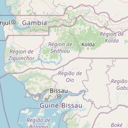

Park location guide

Geography guide, regional context, and park location map for Saloum Delta National Park

Saloum Delta National Park park geography, regions, and map view in Senegal
Understand where Saloum Delta National Park sits in Senegal through a broader geographic reading of the surrounding landscape, nearby location context, and its mapped position within the national park landscape.

How Saloum Delta National Park fits into Senegal

Senegal is a West African country along the Atlantic coast, bordered by Mauritania, Mali, Guinea, and Guinea-Bissau. It nearly surrounds The Gambia and shares a maritime border with Cape Verde. The capital is Dakar.

Wider geography shaping Saloum Delta National Park in Senegal

Senegal is situated in West Africa along the Atlantic Ocean coast. It borders Mauritania to the north, Mali to the east, Guinea to the southeast, and Guinea-Bissau to the southwest. The country nearly surrounds The Gambia, a narrow strip along the Gambia River that separates the Casamance region from the rest of Senegal.

Map view of Saloum Delta National Park

Use this park location map to pinpoint Saloum Delta National Park in Senegal, understand its exact geographic position, and read its mapped placement within the surrounding landscape more clearly.

Pigeon | © OpenStreetMap contributors

Location context for Saloum Delta National Park

Fatick Region
Park atlas

Compare adjacent coastal wetlands, delta ecosystems, and regional protected landscapes in West Africa

Explore Other National Parks and Protected Areas Near Saloum Delta
Continue your park exploration from Saloum Delta National Park by browsing other protected areas and national parks that feature similar coastal wetlands and delta ecosystems in West Africa. Compare their distinct geographic features, conservation landscapes, and regional contexts to deepen your atlas-style discovery of this diverse natural and cultural heritage.
National parkGambia

Niumi National Park: Gambia's Extensive Mangrove Forest and Coastal Wetland Protected Area

Explore the mapped boundaries and unique delta geography of this important national park.

Niumi National Park, situated in The Gambia, is a crucial protected coastal area celebrated for its vast Rhizophora mangrove forests and diverse wetland ecosystems. As a designated national park and Ramsar site, it serves as a critical habitat for numerous migratory bird species, particularly terns, and supports vulnerable marine life. Its landscape is characterized by tidal channels, brackish lagoons, and intertidal mudflats, creating a dynamic and ecologically significant protected zone that is a focal point for understanding West African coastal geography and conservation.

Area
49.4 km²
Established
1987
IUCN
II
Relief
Lowland
National parkGambia

Tanbi Wetland Complex National Park: A Mapped Protected Area in The Gambia

Explore its protected boundaries and regional landscape.

Delve into the geographic identity of Tanbi Wetland Complex National Park, a designated protected area within The Gambia. This page provides essential atlas-level information, focusing on its mapped natural landscape and its role as a significant national park. Understand the park's protected status and its geographical context along the Gambia River, offering a clear entry point for conservation landscape discovery.

Area
45 km²
Established
2001
IUCN
II
Relief
Lowland
Nature reserveGambia

Abuko Nature Reserve: A Protected Nature Reserve in Gambia's Landscape

Explore its mapped boundaries and geographic context.

Abuko Nature Reserve is a protected natural area situated in Gambia, offering a distinct focus for understanding protected landscapes. This entry provides essential details for atlas-based discovery, highlighting the reserve's mapped boundaries and its role within the regional geography. Examine Abuko Nature Reserve to gain clarity on its protected status and its contribution to the mapped natural terrain of West Africa.

Area
1.07 km²
Established
1968
IUCN
IV
Relief
Lowland
National parkGambia

Tanji Bird Reserve National Park: Coastal Wetlands and Avian Diversity in Gambia

Explore unique geography and protected landscape boundaries.

Tanji Bird Reserve National Park showcases a distinctive coastal landscape where the Atlantic Ocean meets lagoons, dry woodland, and dune scrub. This 612-hectare protected area in The Gambia is celebrated for its incredible birdlife, with nearly 300 species recorded, including significant Palearctic migrants and the nation's sole breeding seabird colonies on the Bijol Islands. The reserve offers a rich context for understanding West African protected areas, mapped terrain, and coastal ecosystem geography.

Area
6.12 km²
Established
1993
IUCN
II
Relief
Lowland
National parkGambia

Kiang West National Park: National Park Detail and Protected Landscape Geography

Explore mapped boundaries and regional context in The Gambia.

Kiang West National Park serves as a crucial point for understanding protected natural areas within The Gambia, West Africa. This national park's identity is rooted in its geographic setting along the Gambia River, offering a distinct landscape context and mapped territory. Users can explore its boundaries and place within the nation's conservation network, contributing to a structured understanding of regional geography and protected lands.

Area
115 km²
Established
1987
IUCN
II
Relief
Lowland
Wildlife reserveGambia

Bao Bolong Wetland Reserve: West African Wildlife Reserve with Extensive Mangrove Ecosystems

Explore mapped terrain and crucial protected wetland boundaries.

Bao Bolong Wetland Reserve in Gambia is a significant protected area renowned for its ecological importance as a Ramsar wetland and Important Bird Area. This wildlife reserve features the tallest mangrove trees in the Senegambia region, transitioning through salt marshes to savanna, all centered around the Bao Bolong tributary's estuary. Its complex hydrological network and diverse habitats support 268 bird species and are crucial for the endangered West African manatee, offering a rich landscape for geographic and protected-area discovery.

Area
220 km²
Established
1996
IUCN
VI
Relief
Lowland
National parkZiguinchor Region

Basse Casamance National Park: National Park with Mapped Boundaries in Ziguinchor Region

Detailed protected landscape and regional geography context.

Basse Casamance National Park serves as a critical protected area, offering users a clear view of its national park designation and its specific geographic location within Senegal. This entity is vital for understanding conservation landscapes and mapped terrain in the Ziguinchor Region. The platform provides structured data on its protected boundaries, allowing for focused atlas exploration and a deeper appreciation of its regional geographic significance without leaving the core park identity.

Area
50 km²
Established
1970
IUCN
II
Climate
Tropical
Watercolor illustration of a river flowing through a landscape with trees, grassy areas, and distant hills under a soft sky
National parkCentral River Division

River Gambia National Park: National Park Geography and Protected Landscape Atlas

Discover mapped boundaries within Central River Division.

River Gambia National Park represents a key protected area within the Central River Division, offering specific geographic insights for atlas exploration. This page details the park's mapped boundaries and its role as a national park, providing a factual basis for understanding its landscape context and regional importance. Explore the geographic features that define this protected natural area.

Area
5.85 km²
Established
1978
IUCN
II
Relief
Lowland

Common questions about visiting, size, designation, and location context for Saloum Delta National Park

Saloum Delta National Park FAQs for park facts, access, geography, and protected area context
Find quick answers about Saloum Delta National Park, including protected-area facts, park geography, trail and visitor context, and how the park fits into its surrounding country and regional landscape.
MoriAtlas Explorer

Continue Your Protected Areas Search Across the Global Atlas

Deepen your exploration by continuing the structured search for national parks and protected areas worldwide. Utilize the comprehensive filtering capabilities to compare different conservation landscapes and refine your understanding of global park geography. Discover more about the distribution and characteristics of protected natural areas.

Global natural geography