Mori Atlas logo
Protected landscapeSan Juan National Forest

Tracing the alpine terrain, glacial valleys, and expansive wilderness boundaries of the Southern Rockies

San Juan National Forest: A Comprehensive Geographic Atlas of Southern Colorado Protected Landscapes

San Juan National Forest spans over 1.8 million acres of southwestern Colorado, serving as a critical protected landscape within the Southern Rockies. This expansive terrain features a dramatic transition from high-alpine summits along the Continental Divide to deep river canyons and mesa country. The region contains significant wilderness areas, historic corridors, and geological formations shaped by glacial activity, creating a complex mountain geography that anchors the southern portion of the state.

national forestSan Juan MountainsSouthern RockiesColoradowilderness areasalpine terrain

San Juan National Forest

Protected landscape

Park overview

Structured park overview, official facts, and landscape profile for San Juan National Forest

San Juan National Forest park facts, protected area profile, and essential visitor context

Review the core facts for San Juan National Forest, including designation, size, terrain, visitor scale, habitats, and operating context in one park-focused overview.

About San Juan National Forest

San Juan National Forest is one of the largest and most ecologically varied national forests in Colorado, encompassing a sweeping portion of the southwestern corner of the state. Stretching across roughly 1.8 million acres, the forest occupies the western slope of the San Juan Mountains, a major subrange of the Southern Rocky Mountains that extends in a rough triangle from Silverton and Telluride south toward the New Mexico line. The terrain within the forest shifts dramatically with elevation, ranging from arid canyon and mesa country in the lower reaches to high alpine ridges, cirques, and tundra above the treeline.

The forest's geography is shaped by the Continental Divide, which forms much of its eastern boundary against the Rio Grande National Forest. To the north, the forest is bordered by the Uncompahgre National Forest, while its southern and western edges descend into the river valleys and plateaus that characterize the Colorado Plateau's transition into the Southern Rockies. This positioning gives the forest an unusually broad ecological range, encompassing montane and subalpine forests of spruce, fir, and pine; large aspen groves that turn gold in autumn; and lower-elevation woodlands of piñon, juniper, and scrub oak where the mountains give way to dry mesa country.

San Juan National Forest is also notable for its network of wilderness areas. The Weminuche Wilderness, the largest in Colorado and one of the largest in the lower 48 states, occupies a significant portion of the forest's central high country. The South San Juan Wilderness extends along the eastern flank, and smaller wilderness tracts such as Lizard Head and Hermosa Creek add further protected landscapes. Together, these wilderness areas preserve some of the most remote and rugged terrain in the region, with peaks rising to more than 14,000 feet.

Cultural and historical layers give the forest additional depth. The Durango and Silverton Narrow Gauge Railroad, a historic steam-era rail line still operating as a tourist and excursion route, traces a route through the heart of the forest along the Animas River corridor. Chimney Rock National Monument, designated in 2012 within the forest's boundaries, preserves an ancestral Puebloan archaeological site with dramatic viewsheds across the surrounding canyons. These features, together with the forest's contemporary role as a recreation destination, reflect the long interaction between people and this landscape, from early Indigenous inhabitants through mining boomtowns to today's hikers, anglers, hunters, and backcountry travelers.

Quick facts and research context for San Juan National Forest

San Juan National Forest was established on June 3, 1905, by a presidential proclamation signed by Theodore Roosevelt. It lies in southwestern Colorado and spans ten counties, including Archuleta, La Plata, San Juan, Hinsdale, Mineral, Conejos, Dolores, Montezuma, Rio Grande, and San Miguel. Its headquarters are located in Durango, and the forest covers approximately 1.8 million acres, including two alpine wilderness areas.

Managed by the U.S. Forest Service under the U.S. Department of Agriculture, San Juan National Forest encompasses the western flank of the San Juan Mountains and extends from high alpine terrain down to canyon country and the mesa landscapes near the McPhee Reservoir and Dolores River basin. Within its boundaries lie the Weminuche Wilderness and South San Juan Wilderness, two of the more substantial designated wilderness areas in Colorado, along with other smaller wilderness tracts. The Durango and Silverton Narrow Gauge Railroad passes through the forest, linking the historic mining town of Silverton with the city of Durango.

Protection and recognition

Documented terrestrial protection scope, management framework, and international recognition records

San Juan National Forest Protection Status and Designated Area Records

San Juan National Forest maintains a documented terrestrial protection scope within its federal administrative boundary. Structured conservation records outline the protected area designation and management framework established for the public land.

Protection details

Protection scope
Terrestrial
Transboundary protection
No
Park context

Deeper park guide and search-rich context for San Juan National Forest

San Juan National Forest history, landscape, wildlife, and travel context

Explore San Juan National Forest through its history, landscape character, ecosystems, wildlife, conservation priorities, cultural context, and seasonal travel timing in a structured park guide built for atlas discovery and search intent.

Why San Juan National Forest stands out

San Juan National Forest is best known for dominating most of the southern San Juan Mountains west of the Continental Divide, an area defined by rugged alpine terrain, high-elevation conifer forests, broad aspen groves, and deep glacial-carved valleys. It contains the Weminuche Wilderness, one of the largest and most remote wilderness areas in Colorado, as well as the South San Juan Wilderness and the Hermosa Creek Wilderness, all of which anchor the forest's reputation as a major Southern Rockies landscape. Beyond wilderness and mountains, the forest is recognized for blending high-elevation scenery with accessible Southwestern Colorado terrain, including canyon country along the Dolores River, the mesa landscapes around McPhee Reservoir, and the archaeological significance of Chimney Rock National Monument. The forest also holds cultural and historical cachet through the Durango and Silverton Narrow Gauge Railroad, a historic rail route that passes through some of the forest's most scenic mountain corridors and has become a defining symbol of the region.
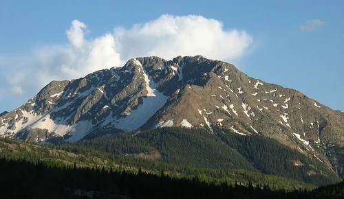
A large, rugged mountain with patches of snow on its slopes, backed by a blue sky with white clouds and fronted by a dark evergreen forest.
A view of a snow-capped peak in San Juan National Forest.

San Juan National Forest history and protected-area timeline

San Juan National Forest was established on June 3, 1905, by a proclamation signed by President Theodore Roosevelt, placing the San Juan Mountains under federal forest protection at a time when conservation thinking was rapidly evolving across the American West. The creation of the forest occurred in the broader Progressive Era push to safeguard watersheds, timber resources, and scenic mountain landscapes from unregulated exploitation.

The forest derives its name from the San Juan River, originally called the Rio San Juan by Spanish explorers, in turn named for Saint John the Baptist (San Juan Bautista). This river heritage reflects the broader Spanish colonial and Mexican-era history of the region, where Spanish nomenclature was applied to many of the principal waterways, peaks, and valleys long before 20th-century federal land designations.

Over the course of the 20th century, San Juan National Forest's role expanded beyond timber and watershed protection to include grazing, recreation, mining-era legacy sites, and the management of designated wilderness. The Weminuche Wilderness, South San Juan Wilderness, Hermosa Creek Wilderness, and Lizard Head Wilderness were all recognized under the National Wilderness Preservation System, ensuring that large portions of the forest would remain in a relatively undeveloped state. Forest headquarters were established in Durango, with ranger district offices in Bayfield, Dolores, and Pagosa Springs, anchoring local management across the forest's vast geographic spread.

In 2012, President Barack Obama used his authority under the Antiquities Act to designate part of the forest as Chimney Rock National Monument, highlighting the area's ancestral Puebloan archaeological significance and adding a major cultural protection layer to the forest's natural resource mission.

San Juan National Forest landscape and geographic character

The landscape of San Juan National Forest is dominated by the southern San Juan Mountains, one of the most geologically complex and visually dramatic ranges in the Southern Rockies. The terrain rises from broad canyon valleys and mesa-like foothills through montane forests into a high-alpine zone of exposed rock, glaciated cirques, and tundra. Elevations within the forest span thousands of feet, producing a layered landscape where pine and juniper foothills give way to aspen and conifer forests, and finally to bare alpine summits and ridgelines near the Continental Divide.

The Continental Divide itself runs along the eastern edge of the forest, separating the watersheds that flow west toward the San Juan River from those that flow east into the Rio Grande basin. Within the forest, the Animas River, Dolores River, and their tributaries have carved deep valleys that provide some of the most scenic and accessible corridors, including the route followed by the Durango and Silverton Narrow Gauge Railroad. The southern portions of the forest transition toward the drier, mesa-like topography characteristic of the Colorado Plateau, with canyons, sandstone formations, and broad tablelands creating a landscape quite different from the alpine core.

Glacial action has left a strong imprint on the highest terrain. U-shaped valleys, hanging tributaries, moraines, and cirques are widespread in the central and northern portions of the forest, especially within the Weminuche and South San Juan Wilderness areas. These landforms combine with sharp ridgelines and high peaks to create a mountain landscape of notable scale and exposure.

San Juan National Forest ecosystems, habitats, and plant life

San Juan National Forest encompasses an unusually broad sweep of ecological zones for a single national forest. Along the elevation gradient from low canyon country to high alpine ridges, the vegetation transitions from piñon-juniper woodlands and ponderosa pine foothills through montane forests of Douglas fir, white fir, and blue spruce, into extensive subalpine forests of Engelmann spruce and subalpine fir. Above the treeline, alpine tundra communities occupy the highest slopes and basins.

Aspen groves are a major ecological feature across much of the forest's middle elevations, forming colorful autumn displays and contributing to habitat diversity. The forest's lower-elevation canyons and mesa edges support oak scrub, mountain shrublands, and grassy openings, creating a rich mosaic when combined with denser conifer stands and riparian corridors along the Animas, Dolores, and San Juan river systems.

The forest's size and elevation range allow it to function as a refuge for species that depend on large, contiguous tracts of montane and subalpine habitat. Wet meadows, beaver-influenced riparian zones, talus slopes, and high alpine basins each host distinct ecological communities. This habitat diversity underpins the forest's standing as one of the more ecologically significant national forests in the Southern Rockies and supports the wilderness designations that protect its wildest subalpine and alpine environments.

San Juan National Forest wildlife and species highlights

San Juan National Forest supports a wide range of wildlife typical of the Southern Rockies, with habitat diversity from low canyons to high alpine basins enabling a rich mix of species. Large mammals such as elk and mule deer are characteristic of the forest's montane and subalpine zones, where they use aspen groves, meadows, and forest edges seasonally. Mountain lions and black bears inhabit the more rugged and forested terrain, while moose have become increasingly associated with willow-dominated riparian areas and beaver wetlands.

The forest's rivers, streams, and high alpine lakes support native sport fish including cutthroat trout, while the surrounding meadows and willow thickets provide habitat for a variety of songbirds and waterfowl. Raptors including golden eagles are associated with the forest's open ridges and canyon country, and the cliffs and talus fields of the high country host species adapted to rocky terrain. The mix of aspen groves, conifer forests, and riparian corridors creates layers of habitat that, together with the forest's sheer size, sustain a rich and regionally significant wildlife community.

San Juan National Forest conservation status and protection priorities

San Juan National Forest plays a significant role in conserving the natural systems of southwestern Colorado, protecting a vast Southern Rockies landscape that includes major watersheds, extensive wilderness areas, and habitat for sensitive wildlife. The forest's size and ecological range give it real conservation weight: it sustains headwaters for the San Juan River basin, anchors large tracts of old-growth and mature conifer forest, and helps maintain habitat connectivity across the broader Rocky Mountain landscape.

The forest's designated wilderness areas are central to its conservation profile. The Weminuche Wilderness, one of the largest wilderness areas in the lower 48 states, anchors a core of minimally developed habitat that protects high-elevation forests, alpine basins, and remote watersheds. The South San Juan Wilderness, Hermosa Creek Wilderness, and Lizard Head Wilderness contribute additional protected landscapes, ensuring that significant proportions of the forest remain free from roads and intensive development.

Beyond wilderness, the forest supports broader conservation objectives including watershed protection, wildlife habitat management, and the preservation of cultural landscapes. The 2012 designation of Chimney Rock National Monument added a major cultural conservation dimension, recognizing the forest's importance as both an ecological and an archaeological refuge, and reinforcing the idea that landscape protection in this part of Colorado depends on integrating natural and cultural values.

San Juan National Forest cultural meaning and human context

San Juan National Forest sits in a region of long and layered human history. The San Juan Mountains and the broader landscape that the forest protects were inhabited long before federal conservation, with ancestral Puebloan peoples occupying the canyons, mesas, and ridgelines of southwestern Colorado for centuries. The 2012 designation of Chimney Rock National Monument within the forest underscores the archaeological depth of this cultural landscape, preserving Puebloan structures, ceremonial sites, and the dramatic ridgeline viewsheds that frame them.

Later Spanish colonial and Mexican-era exploration introduced enduring place names to the region, including the naming of the San Juan River (Rio San Juan) after Saint John the Baptist. The 19th-century mining boom in the San Juan Mountains brought a different kind of cultural imprint, with boomtowns such as Silverton and Telluride rising amid the peaks and the later construction of the Durango and Silverton Narrow Gauge Railroad threading through the forest's central mountain corridor. Today, this railroad remains both an active heritage rail line and a cultural touchstone for the region, connecting modern visitors to the mining-era past.

These combined cultural layers, Indigenous, Spanish, mining-era, and 20th-century conservation, give the forest a rich human dimension that complements its natural setting and continues to shape how it is experienced and managed.

Top sights and standout views in San Juan National Forest

Among San Juan National Forest's most distinctive qualities is its sheer scale: more than 1.8 million acres of southwestern Colorado protected land, spanning everything from alpine ridge to canyon country. Its combination of major wilderness areas, including the Weminuche and South San Juan Wilderness, with accessible front-country corridors along the Animas and Dolores rivers makes it both a wild and a welcoming destination.

The forest's landmarks stand out clearly. Chimney Rock National Monument provides a cultural anchor with ancestral Puebloan significance, while the Durango and Silverton Narrow Gauge Railroad offers one of the most iconic mountain rail journeys in the United States. Together with peaks, high passes, broad aspen stands, and the dramatic transition from the San Juan Mountains into the Colorado Plateau, these features define the forest's distinctive identity.

Best time to visit San Juan National Forest

The experience of San Juan National Forest shifts with elevation and season, so a visit's character depends significantly on timing. Summer, from roughly late June into early September, is the most accessible period for exploring the alpine portions of the forest, when high mountain passes, trails, and wilderness areas are typically free of deep snow. This is also the season when wildflower meadows are at their peak and the Animas River corridor and other canyon routes are most comfortably traversed.

Autumn, generally from mid-September into mid-October, is widely regarded as one of the most scenic times in the forest, when the large aspen groves across the middle elevations turn gold and the high country often settles into clear, crisp weather. Winter brings deep snow to the higher elevations and transforms the forest into a snow-based landscape, while spring runoff and early green-up add a fresh seasonal character to the lower elevations. Each season brings out a different face of the forest, from high-country wildflowers and aspen color to snowy alpine solitude.

Monthly climate preview

Long-term representative monthly averages documenting temperature ranges and precipitation patterns

San Juan National Forest Climate Normals, Annual Temperature and Precipitation Profiles

San Juan National Forest exhibits measured long-term climate normals across representative high-elevation terrain, tracking average monthly temperature extremes and daily precipitation rhythms from NASA Power datasets spanning 1991 to 2020. Reviewing the complete twelve-month record clarifies multi-season thermal shifts and precipitation variations without relying on live forecasts.
Annual mean2 °C
-9 °C15 °C
Jan-9°
Feb-8°
Mar-4°
Apr
May
Jun12°
Jul15°
Aug14°
Sep10°
Oct
Nov-3°
Dec-8°
Warmest month
July

15.3 °C

Coolest month
January

-9 °C

Wettest month
August

2.1 mm/day

Driest month
June

0.7 mm/day

Park location guide

Geography guide, regional context, and park location map for San Juan National Forest

San Juan National Forest park geography, regions, and map view in United States of America

Understand where San Juan National Forest sits in United States of America through a broader geographic reading of the surrounding landscape, nearby location context, and its mapped position within the national park landscape.

How San Juan National Forest fits into United States of America

The United States of America is a federal presidential republic and one of the world's largest countries by area and population. It consists of 50 states across a vast territory spanning multiple time zones, with its capital in Washington, D.C. and largest city in New York City. The nation has a diverse economy, influential political system, and significant cultural and military presence globally.

Wider geography shaping San Juan National Forest in United States of America

The United States occupies a vast territory in North America, bordered by Canada to the north and Mexico to the south. The 48 contiguous states stretch from the Atlantic to the Pacific Ocean, while Alaska occupies the northwestern region and Hawaii is an archipelago in the Pacific. The country encompasses diverse terrain including the Rocky Mountains, Appalachian Mountains, Great Plains, and extensive river systems.

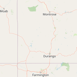
Map view of San Juan National Forest

Use this park location map to pinpoint San Juan National Forest in United States of America, understand its exact geographic position, and read its mapped placement within the surrounding landscape more clearly.

Pigeon | © OpenStreetMap contributors

Location context for San Juan National Forest

Colorado
Recorded earthquake history

Examine the San Juan National Forest Earthquake History Catalogue

Explore the recorded seismic history associated with the diverse terrain of San Juan National Forest. This MoriAtlas dataset allows you to review historical earthquake events by their proximity to the forest, offering a factual reference for geographic and seismic analysis within the Southern Rockies.

San Juan National Forest Earthquake History

Catalogued events

24 events

Strongest magnitude

Magnitude 4.5

Most recent event

Jul 5, 2026

This history includes earthquakes recorded inside the park or within 50 km of its borders

Visual reference for alpine peaks, conifer forests, and Southern Rockies terrain

San Juan National Forest Photos and Protected Landscape Scenery

Visual documentation captures the rugged topography, high alpine ridges, and deep river valleys defining the region. Examining these protected landscapes reveals the dramatic environmental gradients stretching from high-elevation wilderness down to Colorado Plateau mesas.

A large, rugged mountain with patches of snow on its slopes, backed by a blue sky with white clouds and fronted by a dark evergreen forest.

A large, multi-panel wooden interpretive sign with a stone base, displaying information about the Continental Divide, situated in a forested area.

Park atlas

Compare surrounding mountain ranges and regional protected areas in the Southern Rockies

Parks Near San Juan National Forest and Connected Protected Landscapes

Browsing nearby national forests and protected reserves reveals the broader ecological continuity of the Southern Rockies. Comparing adjacent alpine terrain and canyon country provides essential context for understanding regional park geography.
Wildlife reserveColorado
Park boundaries overlap#1 closest

Northwest

Lizard Head Wilderness: Mapping the San Juan Mountains Protected Alpine Terrain

High elevation geography and volcanic wilderness in Colorado

Lizard Head Wilderness is a federally protected area in southwestern Colorado characterized by steep ridgelines, dramatic volcanic geology, and alpine basins. It protects a rugged mountain landscape featuring the iconic Lizard Head spire and a cluster of high-elevation peaks including Mount Wilson, El Diente Peak, and Wilson Peak. The area offers a significant study in remote high-mountain geography and watershed protection within the San Juan range.

Area
167.17 km²
Established
1980
IUCN
Ib
Relief
Mountain
Watercolor painting of soft, layered mountain ranges behind green hills and patches of evergreen trees on a white background.
Protected landscapeColorado
Park boundaries overlap#2 closest

East

Rio Grande National Forest: Atlas and Geographic Profile of a Southern Colorado Landscape

Watershed geography and Continental Divide terrain analysis.

Rio Grande National Forest represents an immense protected landscape encompassing diverse terrain from high desert steppe to rugged alpine peaks. This profile details the forest's hydrological significance as the source of the Rio Grande and its role as a massive ecological transition zone in the Mountain West. Examine the boundaries and mountain geography that define this critical protected area.

Area
7,500 km²
Established
1908
Relief
Mountain
Climate
Boreal
Protected landscapeColorado
About 9.4 km away#3 closest

North

Uncompahgre National Forest: Protected Landscapes and Geographic Features in Colorado

Mapping the arid plateau and high-country San Juan wilderness zones.

Uncompahgre National Forest represents a vast protected area in the American West, spanning iconic landscapes from the dry, pinyon-juniper covered Uncompahgre Plateau to the dramatic, jagged ridges of the northern San Juan Mountains. This atlas entry provides essential context on its alpine wilderness designations, high-country topography, and the unique geological transitions that define its status as a critical Colorado resource for regional landscape analysis.

Area
3,865.68 km²
Established
1905
Relief
Mountain
Climate
Alpine
National parkMontezuma County
10 km away#4 closest

Southwest

Mesa Verde National Park: Protected Landscape Atlas and Geographic Identity

Discover the mapped terrain and regional context of this national park.

Mesa Verde National Park serves as a critical protected landscape within Montezuma County, offering distinct insights into regional geography and mapped terrain. This entry details the park's identity as a National Park, emphasizing its geographic setting and providing a foundation for atlas-driven exploration. Understand the park's place within the broader landscape context and its significance as a mapped protected area, ideal for focused geographic study.

Area
212.4 km²
Established
1906
IUCN
II
Visitors
463.1K annual
Watercolor painting of a mountain landscape with light green rolling hills in the midground and pale, soft-toned mountain peaks in the background.
Protected areaColorado
11 km away#5 closest

North

Mount Sneffels Wilderness: Mapping the High Alpine Terrain of the San Juan Mountains

Protected mountain geography in southwestern Colorado

Mount Sneffels Wilderness protects a dramatic cluster of peaks in the San Juan range, characterized by glacial cirques, expansive talus fields, and sharp ridgelines. As a vital component of the Colorado backcountry, this area provides a window into high-altitude ecological transition zones, from dense conifer forests to exposed granite summits that define the character of the Uncompahgre National Forest.

Area
67.04 km²
Established
1980
IUCN
Ib
Relief
Mountain
A pale watercolor painting showing a panoramic view of mountain ranges in the background, a coniferous forest on a small hill, and a meadow with wildflowers in the foreground.
Wildlife reserveColorado
28 km away#6 closest

Northeast

La Garita Wilderness: Exploring the High Alpine Geography of Southern Colorado

Volcanic terrain and protected mountain wilderness atlas

La Garita Wilderness serves as a primary example of protected high-alpine geography in southern Colorado. This atlas entry examines the undulating volcanic ridges, glacial cirques, and alpine basins that define the area, including the prominent peak of San Luis. It highlights the integration of significant trail systems within this protected landscape, offering a clear perspective on the physical geography and conservation value of the La Garita mountain range.

Area
524.58 km²
Established
1964
IUCN
Ib
Relief
Mountain
A horizontal watercolor painting depicting soft green rolling hills and distant mountains under a white sky.
Wildlife reserveColorado
38 km away#7 closest

Northeast

Powderhorn Wilderness: A High-Elevation Protected Landscape in the San Juan Mountains

Basaltic plateaus and vast alpine tundra in Colorado

Powderhorn Wilderness protects a distinct highland environment in southwestern Colorado. Characterized by dark basaltic caprocks and deep glacial cirques, this area serves as a critical headwaters system for the Gunnison River, supporting a complex transition from sagebrush steppe to subalpine forest and wind-swept tundra. The geography remains largely defined by its volcanic heritage and the primitive character of its remote plateau summits.

Area
251.1 km²
Established
1993
IUCN
Ib
Relief
Mountain
A watercolor painting showing a panoramic view of rolling green mountains with a winding stream through a forested valley.
Protected landscapeUtah
50 km away#8 closest

Northwest

Manti, La Sal National Forest: Geographic Overview of Utah's Mountain and Canyon Landscapes

Mapped protected forest boundaries across the Colorado Plateau

Spanning over one million acres, Manti, La Sal National Forest defines a critical segment of Utah geography. This protected landscape encompasses diverse terrain including subalpine mountains, aspen-rich uplands, and deep canyon networks. Use this atlas to examine the distinct environmental characteristics that separate the northern forested plateaus from the southern wilderness canyons.

Area
5,143.09 km²
Established
1950
IUCN
V
Visitors
900K annual

Common questions about visiting, size, designation, and location context for San Juan National Forest

San Juan National Forest FAQs for park facts, access, geography, and protected area context

Find quick answers about San Juan National Forest, including protected-area facts, park geography, trail and visitor context, and how the park fits into its surrounding country and regional landscape.
MoriAtlas Explorer

Continue Your Protected Areas Search Across the Global Atlas

Deepen your exploration by continuing the structured search for national parks and protected areas worldwide. Utilize the comprehensive filtering capabilities to compare different conservation landscapes and refine your understanding of global park geography. Discover more about the distribution and characteristics of protected natural areas.

Global natural geography