Mori Atlas logo
Protected areaSandr Brdy

Analyzing the ecological diversity of the Brda outwash plain and its post-glacial water systems.

Sandr Brdy Protected Area: Glacial Landscapes and Natura 2000 Biodiversity in Northern Poland

(Sandr Brdy (PLH220026))

Sandr Brdy serves as a critical reference site for lowland habitat diversity within the Pomeranian Voivodeship. Shaped by glacial meltwater along the Równina Charzykowska, this protected area preserves fifteen distinct Natura 2000 habitat types, ranging from open sand-grasslands and inland dunes to dystrophic lobelia lakes and active raised bogs. The site provides essential continuity for rare species and hydrologically linked ecosystems.

Natura 2000Special Area of ConservationPomeranian VoivodeshipRównina Charzykowskaoutwash plainglacial landscape

Sandr Brdy

Protected area

Park overview

Structured park overview, official facts, and landscape profile for Sandr Brdy

Sandr Brdy park facts, protected area profile, and essential visitor context

Review the core facts for Sandr Brdy, including designation, size, terrain, visitor scale, habitats, and operating context in one park-focused overview.

About Sandr Brdy

Sandr Brdy represents one of the most habitat-diverse Natura 2000 sites in northern Poland, anchoring a large block of protected territory on the Równina Charzykowska, the outwash plain that links the Brda river basin with the wider Bory Tucholskie system. Designated as a Special Area of Conservation under the EU Habitats Directive and registered with the site code PLH220026, it aims to preserve the natural structure and long-term viability of glacial landforms, wetlands, and forests that remain largely intact in this part of the Polish lowlands.

The site's defining feature is its geological inheritance. Pleistocene glaciation left behind a complex mosaic of sandy outwash plains, kettle holes, moraine remnants, and post-glacial lake basins. Combined with a relatively cool, humid climate, this geology produced a patchwork of inland dunes, acidic heathlands, dystrophic lakes, lobelia-type oligotrophic lakes, and peat-forming wetlands. Within a single protected area, one can encounter almost every major lowland habitat type characteristic of northeastern Poland, from dry sand grasslands on dune crests to floating rafts of Sphagnum overlying transitional mires.

Ecologically, Sandr Brdy plays an important role as a refuge for species that have declined elsewhere in central Europe. Its old-growth and semi-natural woodlands, including acidophilous oak forest and boggy birch-pine forests, support breeding populations of species sensitive to disturbance. Its wetlands and lakes sustain amphibians such as the fire-bellied toad and great crested newt, while its streams and the broader Brda river system maintain viable populations of pond lamprey and the thick-shelled river mussel, a mollusc highly sensitive to water-quality degradation.

Larger mammals also use the area as part of a wider lowland wilderness continuum. The presence of breeding gray wolf, alongside established populations of European beaver and Eurasian otter, indicates that the conditions for intact predator-prey systems, clean watercourses, and resilient riparian habitats remain largely intact. From a conservation standpoint, the site functions less as an isolated reserve than as a critical node within the larger Bory Tucholskie ecological network.

Quick facts and research context for Sandr Brdy

Sandr Brdy is classified as a Special Area of Conservation (SAC) under the European Union Natura 2000 framework, designated to protect natural habitats and species listed under the EU Habitats Directive. The site sits in the Pomeranian Voivodeship and falls within the Równina Charzykowska mesoregion, the outwash plain associated with the Brda river basin and the broader Tuchola Forest area.

The protected territory extends across roughly 7,492 hectares and encompasses a striking variety of habitat types, including fifteen Natura 2000 habitat codes ranging from inland dunes and lobelia lakes to raised bogs, transition mires, acidophilous oak forests, boggy birch and pine woodlands, riparian alder and ash forests, and Cladonia pine woods. This habitat diversity, combined with the presence of iconic species such as wolf, beaver, otter, and Fen orchid, makes Sandr Brdy a key conservation asset in the Bory Tucholskie region.

Protection and recognition

Explore the documented terrestrial conservation scope and Natura 2000 listings.

Sandr Brdy Protection Status and International Recognition Data

Sandr Brdy features structured records detailing terrestrial protection status, management scope, and official designation sources. Official records outline international recognition including Natura 2000 listings to support comprehensive geographic analysis.

International recognition

Protection details

Protection scope
Terrestrial
Park context

Deeper park guide and search-rich context for Sandr Brdy

Sandr Brdy history, landscape, wildlife, and travel context

Explore Sandr Brdy through its history, landscape character, ecosystems, wildlife, conservation priorities, cultural context, and seasonal travel timing in a structured park guide built for atlas discovery and search intent.

Why Sandr Brdy stands out

Sandr Brdy is best known for the exceptional variety of Natura 2000 habitat types it holds within a relatively compact area, ranging from inland dunes with sand-grasslands to rare lobelia lakes, dystrophic waters, raised and transitional peatlands, and boggy boreal forests. The site is also distinguished by the presence of multiple rare and strictly protected species, including the lady's slipper orchid, floating water-plantain, Fen orchid, thick-shelled river mussel, great crested newt, and gray wolf, which together signal both habitat integrity and long-term ecological continuity across the Brda outwash plain.

Sandr Brdy history and protected-area timeline

Sandr Brdy was formally established as part of the European Union Natura 2000 network, designated to ensure long-term protection of habitats and species listed under the EU Habitats Directive. Its registration under the site code PLH220026 ties it to a broader European framework for the conservation of biological diversity, in which Poland's network of sandr and lowland peatland sites plays an important role.

The wider landscape that Sandr Brdy protects has been shaped historically by glacial processes rather than by intense human transformation. The outwash plain of the Brda, its dune fields, and its embedded lake basins were laid down at the end of the last glaciation and have remained relatively lightly settled, sustaining traditional low-intensity land uses such as forestry, small-scale peat cutting, and limited grazing. Over time, this combination of remote setting, acidic soils, and waterlogged terrain helped preserve both biological diversity and a striking continuity of natural habitats.

The site's inclusion in the Natura 2000 network reflects the broader late 20th and early 21st century recognition that these glacial-sandr landscapes constitute irreplaceable reservoirs of rare habitat types in central Europe, requiring formal protection in addition to any national-level landscape or park designations.

Sandr Brdy landscape and geographic character

The landscape of Sandr Brdy is essentially a story of glacial inheritance. The area lies within the Równina Charzykowska, an extensive outwash plain formed by meltwater flowing from retreating Pleistocene ice sheets. Sandy substrates dominate the terrain, interrupted by low moraine ridges, kettle-hole depressions, and a network of post-glacial lakes and slow-moving channels along the Brda system.

Inland dunes are among the area's most visually distinctive features, sometimes capped by open sand-grasslands with Corynephorus and Agrostis species. Where the watertable rises, the same sandy terrain transitions abruptly into peat-forming systems, producing raised bogs on flat sandy platforms, transition mires along former lake margins, and calcareous fens where mineral-rich groundwater seeps to the surface.

The lakes themselves vary significantly in character. Some are oligotrophic lobelia lakes, with clear water and characteristic isoetid vegetation, while others are dystrophic, stained brown by humic acids from surrounding peatlands. Old river channels and natural eutrophic waters add still another layer, creating a landscape where open water, mire, heath, and forest stand within sight of one another.

Sandr Brdy ecosystems, habitats, and plant life

Sandr Brdy protects an unusually complete spectrum of lowland habitats for a single Natura 2000 site. The list of protected habitat types includes inland dunes with sand-grasslands, lobelia lakes, hard-water oligo- and mesotrophic lakes with charophyte beds, dystrophic natural water bodies, dry heathlands, lowland hay meadows, active raised bogs, transition mires and quaking mires, calcareous fens, acidophilous oak forests, boggy birch and pine woodlands, riparian alder and ash forests, and Cladonia-rich reindeer-lichen pine forests.

Collectively, these habitats form an ecological gradient from dry, acidic sand to fully waterlogged, nutrient-poor peat, with every intermediate step represented. The presence of multiple lake types in close proximity, including extremely clear lobelia waters and brown dystrophic pools, gives the site an exceptional capacity for comparative ecological study, while the contiguous tracts of boggy woodland and heathland provide continuity for species that require large, unbroken habitat blocks.

Vegetation patterns reflect this mosaic character. In the driest dune fragments, sparse sand-grasslands and lichen-rich pinewoods are characteristic. Slightly moister zones support dry heath dominated by Calluna and Genista. Around the lakes, floating rafts of bog moss and emergent sedge communities dominate, while the forested wetlands, including alder swamps and boggy birch-pine stands, are some of the most biodiverse woody habitats in the area.

Sandr Brdy wildlife and species highlights

Sandr Brdy supports a remarkable fauna profile for a lowland protected area, including several large mammals and a long list of habitat-specialist species associated with clean water, old-growth forest, and intact wetlands.

The site's mammal community includes the European beaver, whose dams and lodges shape many of the smaller watercourses, and the Eurasian otter, a predator heavily reliant on fish-rich, unpolluted rivers and lakes. Gray wolf is also recorded from the area, indicating functioning large-carnivore dynamics across the broader landscape.

Amphibians are another important component of the fauna. Fire-bellied toad, a species that requires a network of small, sun-warmed ponds for breeding, inhabits suitable wetland fragments, alongside the great crested newt, one of Europe's most threatened amphibians. Reptiles and invertebrates tied to peatlands and sand habitats also benefit from the continuity of habitat types.

Aquatic fauna is equally significant. Pond lamprey, a jawless fish whose larvae require clean, sandy-bottomed streams, is among the protected species associated with the site, as is the thick-shelled river mussel, an extremely sensitive bivalve that depends on stable riverbeds and high water quality. The combination of these species suggests that the hydrological systems across Sandr Brdy remain in a relatively undisturbed state.

Sandr Brdy conservation status and protection priorities

Sandr Brdy is protected primarily through its designation as a Special Area of Conservation within the European Natura 2000 network, with site code PLH220026. This designation obligates Poland to maintain or restore the favorable conservation status of the listed natural habitat types and species, and to prevent deterioration of the habitats and significant disturbance to the species for which the site is designated.

The area's conservation significance lies in its combination of habitat rarity and habitat integrity. Many of the protected habitat types, especially lobelia lakes, raised bogs, transition mires, and inland dunes with sand-grasslands, have undergone severe decline across central Europe due to drainage, peat extraction, afforestation, and land-use intensification. Sandr Brdy retains substantial areas of these habitats in relatively natural condition, making it an important reference site for their long-term survival in Poland.

The site also anchors a wider conservation network that includes adjacent protected areas such as Zaborski Landscape Park. This connectivity matters for wide-ranging species such as wolf and otter, and for ecological processes such as hydrological flow, peat accumulation, and forest dynamics. Conservation management on the site is therefore oriented not only toward preserving individual habitat patches but also toward maintaining the broader ecological functions of the sandr landscape.

Sandr Brdy cultural meaning and human context

Sandr Brdy lies within the historic landscape of the Bory Tucholskie, a region long characterised by sandy soils, extensive forests, and a sparse, dispersed settlement pattern. Traditional livelihoods in this part of Poland have included small-scale forestry, peat cutting, hay-making on naturally nutrient-poor meadows, and limited grazing, all of which have shaped and, in some places, maintained the open habitats found within the protected area today.

The Brda river itself has historical importance for the region, both as a transport route and as a focus of local identity. Communities around the Brda developed distinct relationships with the landscape, including traditions tied to its lakes and waterways. While Sandr Brdy is fundamentally an ecological designation rather than a cultural site, the cultural history of low-intensity land use in this part of the Pomeranian Voivodeship is part of the broader context that has allowed its habitats to persist in their current form.

Top sights and standout views in Sandr Brdy

Sandr Brdy stands out for combining fifteen different Natura 2000 habitat types within a single protected area, ranging from inland dunes to active raised bogs and lobelia lakes, making it one of the most habitat-diverse Natura 2000 sites in the Polish lowlands.

The site is also notable for the survival of several emblematic species, including gray wolf, European beaver, Eurasian otter, great crested newt, pond lamprey, thick-shelled river mussel, and rare orchids such as the lady's slipper, all of which depend on the continuity of natural processes across the sandr landscape. These features, together with the site's location within the wider Bory Tucholskie conservation network, give Sandr Brdy a strong profile as a lowland wilderness reference site in northern Poland.

Best time to visit Sandr Brdy

The character of Sandr Brdy shifts noticeably with the seasons in ways that reflect its wetland and forest mosaic. Late spring and early summer are typically the most rewarding period for observing amphibians such as the fire-bellied toad and great crested newt, while the broad range of flowering plants on heathlands and peatlands, including protected orchids, becomes more conspicuous.

Late summer and early autumn bring intensified colour in the heathlands and bog margins, as Calluna heath and mire vegetation reach their peak visual expression, and many of the lakes, especially dystrophic and lobelia types, are at their clearest. Winter can also be an atmospheric time to experience the area, when snow accentuates the contrast between open bogs, frozen lake surfaces, and the dark conifer-dominated forests of the Brda outwash plain. Access conditions, however, depend heavily on local weather and any restrictions tied to active conservation management.
Monthly climate preview

Long-term representative point measurements tracking monthly temperature and precipitation variation across the protected terrain

Sandr Brdy Climate Normals, Annual Temperature and Precipitation Profiles

Historical climatology data reveals the recorded monthly temperature range and precipitation rates measured at a representative coordinate within Sandr Brdy. Analyzing the complete twelve-month sequence provides precise historical context for long-term meteorological patterns across the protected area.
Annual mean8 °C
-3 °C18 °C
Jan-3°
Feb-2°
Mar
Apr
May12°
Jun16°
Jul18°
Aug18°
Sep14°
Oct
Nov
Dec-1°
Warmest month
July

18.3 °C

Coolest month
January

-2.7 °C

Wettest month
July

2.8 mm/day

Driest month
April

1.3 mm/day

Park location guide

Geography guide, regional context, and park location map for Sandr Brdy

Sandr Brdy park geography, regions, and map view in Poland

Understand where Sandr Brdy sits in Poland through a broader geographic reading of the surrounding landscape, nearby location context, and its mapped position within the national park landscape.

How Sandr Brdy fits into Poland

Poland, officially the Republic of Poland, is a Central European country spanning from the Baltic Sea in the north to the Carpathian Mountains in the south. It borders Germany, Czech Republic, Slovakia, Ukraine, Belarus, Lithuania, and Kaliningrad Oblast. The country has a temperate climate, diverse landscapes, and is known for its rich history, cultural heritage, and strong economic position within the EU.

Wider geography shaping Sandr Brdy in Poland

Poland occupies 312,696 km2 in Central Europe, extending from the Baltic Sea coast in the north to the Sudetes and Carpathian Mountains in the south. It borders Germany to the west, Czech Republic and Slovakia to the south, Ukraine and Belarus to the east, and Lithuania and Kaliningrad Oblast to the northeast. The landscape includes lowland plains, uplands, and mountain ranges.

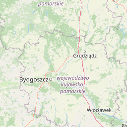
Map view of Sandr Brdy

Use this park location map to pinpoint Sandr Brdy in Poland, understand its exact geographic position, and read its mapped placement within the surrounding landscape more clearly.

Pigeon | © OpenStreetMap contributors

Location context for Sandr Brdy

Pomeranian Voivodeship
Park atlas

Compare adjacent glacial landscapes and regional habitats across northern Poland.

Other Parks and Protected Areas Near Sandr Brdy

Browsing parks near Sandr Brdy reveals connected outwash plains, post-glacial lakes, and fragile mire ecosystems across the Pomeranian landscape. Comparing these neighboring protected areas provides deeper geographic context into the wider Bory Tucholskie conservation network.
A pale, soft-toned watercolor painting of a calm lake shore with marshy grasses in the foreground and a line of green trees and rolling hills in the background.
National parkPomeranian Voivodeship
Park boundaries overlap#1 closest

South

Park Narodowy „Bory Tucholskie”: Geography of a Polish National Park and Protected Forest

Lowland pine ecosystems and glacial water networks

Located in the Pomeranian Voivodeship, Park Narodowy „Bory Tucholskie” protects a significant remnant of the Tuchola Forest. The terrain, characterized by postglacial sandy plains, inland dunes, and acidic lobelia lakes, provides a critical reference site for studying forest ecology and glacial geomorphology within the Polish national park system.

Area
46.13 km²
Established
1996
Visitors
33K annual
Relief
Lowland
Watercolor painting of a soft, hazy wetland landscape with green foliage, pink marsh vegetation, and distant hills in pale tones.
Nature reservePomeranian Voivodeship
Mapped location lies within the park boundary#2 closest

North

Rezerwat przyrody Dolina Kulawy: Mapping Peatlands and Wetlands in Pomeranian Voivodeship

A protected landscape featuring soligenous mires and glacial lakes.

Discover the intricate geography of Rezerwat przyrody Dolina Kulawy, a nature reserve centered on the Kulawa River valley in northern Poland. This protected area offers a unique look at soligenous peatlands, floodplain forests, and mesotrophic lake systems, providing essential context for the post-glacial landscape of the Bory Tucholskie region.

Area
1.546 km²
Established
2009
Relief
Lowland
Climate
Temperate
Nature reservePomeranian Voivodeship
Mapped location lies within the park boundary#3 closest

Southeast

Rezerwat przyrody Moczadło: Protected Nature Reserve and Lobelia Lake in Pomeranian Voivodeship

Mapped ecological zone within the Bory Tucholskie lake region

Gain insight into the protected landscape of Rezerwat przyrody Moczadło, a nature reserve in Pomeranian Voivodeship defined by its exceptionally clear oligotrophic waters. This site offers valuable data for those studying post-glacial lake ecosystems, rare aquatic flora, and the sensitive transition zones between open water and peat-forming pine forest landscapes.

Area
0.262 km²
Established
2011
Water
Major water bodies
Watercolor painting of a river flowing through a forested area with colorful fields
National parkPomeranian Voivodeship
Park boundaries overlap#4 closest

South

Tuchola Forest National Park: Explore Poland's Largest Protected Woodland and Glacial Lakes

Detailed maps and geographic context of unique forest ecosystems and terrain.

MoriAtlas offers a comprehensive geographic overview of Tuchola Forest National Park, a vital protected area in Pomeranian Voivodeship, Poland. This page delves into the park's identity as Poland's largest contiguous forest, distinguished by its post-glacial landscape. Users can explore the mapped boundaries of its extensive coniferous forests, numerous interconnected glacial lakes, dynamic dunes, and ecologically rich peatlands. It serves as a key entry point for understanding the park's unique terrain and its significant place within the broader regional geography and protected lands atlas.

Area
46.13 km²
Established
1996
IUCN
II
Visitors
33K annual
Protected landscapePomeranian Voivodeship
Park boundaries overlap#5 closest

North

Zaborski Park Krajobrazowy: Geographic Profile of a Polish Protected Landscape Area

Tuchola Forest region, Pomeranian Voivodeship

Investigate the unique terrain of Zaborski Park Krajobrazowy, a protected landscape defined by its dense network of glacial lakes and sandy outwash plains. This territory provides a comprehensive view of northern Polish lowland geography, highlighting the ecological significance of its river valleys and relic forest habitats within the broader Tuchola Forest ecosystem.

Area
340.3 km²
Established
1990
Relief
Lowland
Climate
Temperate
Nature reservePomeranian Voivodeship
About 3.3 km away#6 closest

Southwest

Rezerwat przyrody Jezioro Małe Łowne: Protected Bog and Lake Landscape in Poland

A nature reserve in Pomeranian Voivodeship's wetland geography.

Located in the heart of the Bory Tucholskie forest region, this nature reserve protects a shallow post-glacial lake and its surrounding mire habitats. The protected area features a dynamic floating bog mat, boggy pine forests, and transitional peatlands, offering a clear look at the lowland hydrology and glacial topography that characterizes this specific part of northern Poland.

Area
0.378 km²
Established
1993
Relief
Lowland
Climate
Temperate
A soft watercolor illustration depicting a flat wetland landscape with low hills in the background and clusters of green trees and shrubs in the foreground.
Nature reservePomeranian Voivodeship
About 4.6 km away#7 closest

North

Mechowisko Radość Nature Reserve: Atlas of Protected Alkaline Fen Landscapes in Pomeranian Voivodeship

A rare calcareous mire ecosystem within the Bory Tucholskie post-glacial terrain

Mechowisko Radość Nature Reserve protects a specialized alkaline peatland ecosystem that developed in a formerly mesotrophic lakeside bay. This site highlights the complex hydrological and ecological processes of the Bory Tucholskie region, where flat, post-glacial landscapes sustain rare orchid and bryophyte assemblages through dedicated active conservation management.

Area
0.096 km²
Established
2013
Relief
Lowland
Scope
Terrestrial
Nature reservePomeranian Voivodeship
About 5.7 km away#8 closest

Southwest

Jezioro Sporackie Nature Reserve: Mapped Geography and Protected Area Context

Exploring the lobelia lake and peatland mosaic in Pomeranian Voivodeship

Jezioro Sporackie Nature Reserve protects a vital ecological gradient ranging from nutrient-poor aquatic habitats to wooded terrestrial margins. The site preserves Sporacz, a glacial lake recognized for its specialized flora, alongside the surrounding transitional mire and forest compartments that form its primary buffer zone in Northern Poland.

Area
0.176 km²
Established
1965
Relief
Lowland
Climate
Temperate

Common questions about visiting, size, designation, and location context for Sandr Brdy

Sandr Brdy FAQs for park facts, access, geography, and protected area context

Find quick answers about Sandr Brdy, including protected-area facts, park geography, trail and visitor context, and how the park fits into its surrounding country and regional landscape.
MoriAtlas Explorer

Continue Your Protected Areas Search Across the Global Atlas

Deepen your exploration by continuing the structured search for national parks and protected areas worldwide. Utilize the comprehensive filtering capabilities to compare different conservation landscapes and refine your understanding of global park geography. Discover more about the distribution and characteristics of protected natural areas.

Global natural geography