Mori Atlas logo
National parkSanjiangyuan National Park

Discover the mapped geographic identity of Asia's three great river sources.

Sanjiangyuan National Park: Qinghai's Vital Headwater Protected Landscape

Sanjiangyuan National Park represents a monumental protected landscape on the Tibetan Plateau in Qinghai, China, critically safeguarding the headwaters of the Yellow, Yangtze, and Mekong rivers. This expansive national park, averaging over 4,700 meters in elevation, offers a unique lens into high-altitude alpine ecosystems, vast wetlands, and critical river source landscapes. Its designation as China's first national park under the modern system highlights its importance for conservation and structured geographic discovery.

High AltitudeWetland ProtectionHeadwatersTibetan PlateauAlpine EcosystemSnow Leopard Habitat

Sanjiangyuan National Park

National park

Park overview

Structured park overview, official facts, and landscape profile for Sanjiangyuan National Park

Sanjiangyuan National Park park facts, protected area profile, and essential visitor context

Review the core facts for Sanjiangyuan National Park, including designation, size, terrain, visitor scale, habitats, and operating context in one park-focused overview.

About Sanjiangyuan National Park

Sanjiangyuan National Park occupies a vast expanse of the Tibetan Plateau in southwestern Qinghai province, protecting the critical watersheds that give rise to three of Asia's greatest rivers. The park's territory spans from the northern slopes of the Kunlun Mountains in the north to the Tanggula Mountains in the south, encompassing a landscape of extraordinary ecological importance and extreme altitude. The area has been recognized as a national priority for conservation since the establishment of the Sanjiangyuan National Nature Reserve in 2000, which was elevated to national-level status in 2003 and subsequently transformed into China's first modern national park in 2021. The park is administered by the Sanjiangyuan National Park Administration Bureau, which operates under joint leadership from Qinghai Province and the National Forestry and Grassland Administration. The park's management framework divides the territory into core protection zones, where human activity is strictly prohibited to allow ecosystems to recover, and general control zones where traditional pastoral activities continue under regulated conditions. This zonal approach reflects the park's dual goals of protecting critical ecological functions while respecting the legitimate livelihoods of local Tibetan communities who have inhabited these grasslands for generations. The park's establishment represents China's commitment to ecological civilization and sustainable development, recognizing that the health of these headwater ecosystems directly affects water security for vast populations downstream.

Quick facts and research context for Sanjiangyuan National Park

Sanjiangyuan National Park is located on the Tibetan Plateau in Qinghai province, China, at the source of the Yellow River, Yangtze, and Mekong. Established as a national park in 2021, it covers approximately 190,700 square kilometers with an average elevation exceeding 4,700 meters. The park is divided into a core protection zone (about 55% of the total area) and a general control zone (about 45%). It succeeded the Sanjiangyuan National Nature Reserve, which was established in 2000 and achieved national-level status in 2003. The park contains significant wetland ecosystems spanning over 31,700 square kilometers and supports populations of endangered species including snow leopard, Tibetan antelope, and black-necked crane. The resident population is predominantly Tibetan, with over 97% of the approximately 116,000 residents belonging to this ethnic group.

Protection and recognition

Documenting terrestrial management scope and transboundary park characteristics

Sanjiangyuan National Park Protection Status and Terrestrial Designations

Official datasets track the terrestrial protection status and transboundary alignment of Sanjiangyuan National Park. Analyzing these formal designations helps geographers map key global wilderness networks and understand regional conservation frameworks.

Protection details

Protection scope
Terrestrial
Transboundary protection
Yes
Core area
105,800 km²
Buffer area
84,900 km²
Park context

Deeper park guide and search-rich context for Sanjiangyuan National Park

Sanjiangyuan National Park history, landscape, wildlife, and travel context

Explore Sanjiangyuan National Park through its history, landscape character, ecosystems, wildlife, conservation priorities, cultural context, and seasonal travel timing in a structured park guide built for atlas discovery and search intent.

Why Sanjiangyuan National Park stands out

Sanjiangyuan is best known as the source region of three of Asia's most important rivers, supplying water to hundreds of millions of people across China and Southeast Asia. The park protects the critical headwater ecosystems of the Yellow River, which is China's second-long river and historically important for Chinese civilization; the Yangtze, the longest river in Asia; and the Mekong, which flows through multiple countries in Southeast Asia. The region is also renowned for its extensive high-altitude wetlands, including the Xingxing Hai, A'nimaqin, and Zhaling-Eling Hu marshland areas, which serve as crucial water retention and purification systems. Sanjiangyuan is further distinguished by its populations of endangered flagship species, particularly the snow leopard and Tibetan antelope (chiru), which inhabit the rugged mountain terrain and open grasslands. The park's designation as China's first national park under the modern national park system also gives it special significance in China's conservation history.
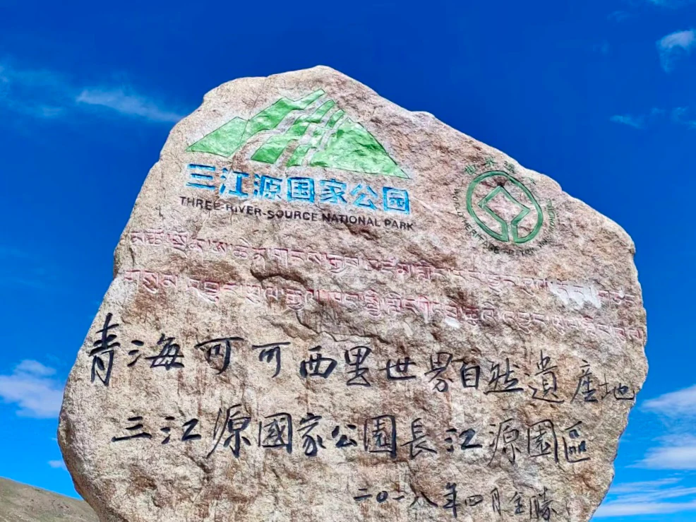
Stone marker with Chinese text and English translation for Three River Source National Park and Qinghai Kekexili World Heritage Site against blue sky
World Heritage Site marker for Sanjiangyuan National Park in Qinghai, China

Sanjiangyuan National Park history and protected-area timeline

The protection history of Sanjiangyuan began with the establishment of the Sanjiangyuan National Nature Reserve in May 2000, formally approved by the State Council of China. The Management Bureau was established in September 2001, and the reserve achieved national-level status in January 2003, reflecting its importance in China's conservation framework. The reserve originally covered approximately 152,300 square kilometers, larger than England and Wales combined, and was organized into 18 subareas managed under a three-zone system: core zones with strict protection and no grazing, buffer zones with limited rotational grazing, and experimental zones allowing sustainable use and scientific research. In 2015, the Chinese government announced plans to establish a new national park system, with Sanjiangyuan designated as a pilot area. The park was formally established in late 2021, becoming China's first national park under this modern system. The transition incorporated the former Sanjiangyuan National Nature Reserve as well as the Hoh Xil nature reserve into a unified protected area. Significant ecological restoration efforts have accompanied these administrative changes, including the relocation of pastoralists from core zones, restrictions on mining and grazing, and programs to restore degraded grasslands. These conservation measures have faced challenges, including questions about the effectiveness of resettlement programs and ongoing concerns about the impacts of climate change on the fragile alpine ecosystem.

Sanjiangyuan National Park landscape and geographic character

The landscape of Sanjiangyuan National Park is defined by its extraordinary altitude and the vast, open terrain of the Tibetan Plateau. The park straddles several major mountain ranges, with the main Kunlun Mountains分布在公园北部, while the Altun Shan, Bayan Har Mountains, and Tanggula Mountains form the western, eastern, and southern boundaries respectively. The central and western portions of the park feature wide valley floors and broad, flat plains interspersed with rolling hills, where extensive areas of alpine swamp meadow and marsh wetlands have developed atop permafrost foundations. These wetlands, including the Xingxing Hai and Guozong Mucha areas, form the critical sponge systems that regulate water flow to the three rivers. The southeastern section, particularly the northern foothills of the Tanggula Mountains, features a more varied terrain of low mountains,高原河湖盆地, and ice-affected permafrost landforms. The park contains significant glacial features, with over 5,000 square kilometers of glaciers concentrated primarily on the Tanggula, Kunlun, and Bayan Har ranges, serving as vital freshwater reservoirs. Lakes are numerous throughout the park, with more than 188 lakes exceeding 0.5 square kilometers in area, including the significant Zhaling and Eling lakes in the Yellow River headwater region. The overall terrain character is one of vast, horizontal openness broken only by mountain ridges and the sinuous lines of rivers and lakes.

Sanjiangyuan National Park ecosystems, habitats, and plant life

Sanjiangyuan hosts a complex of high-altitude ecosystems that are both ecologically significant and environmentally fragile. The dominant ecosystem types include alpine meadow and alpine steppe, which together cover approximately 69.5% of the park's area and form the primary grazing lands for local pastoralists. Alpine wetlands, encompassing over 31,700 square kilometers, represent another critical ecosystem type, providing essential water regulation services and habitat for numerous species. Forest and shrubland ecosystems are more limited in extent, covering approximately 496 square kilometers, with main concentrations of juniper forest in the high canyons of the Lancang (Mekong) source region. The park supports remarkable biodiversity, with records of more than 2,200 species of vascular plants and 310 species of vertebrates. Seven major vegetation type groups have been documented, including forest, shrubland, meadow, steppe, desert, alpine冻原with sparse vegetation, and wetland aquatic vegetation. The ecosystems are characterized by their vulnerability to climate change and human disturbance, with permafrost degradation, grassland deterioration, and wetland shrinkage identified as significant environmental concerns. The park's ecological significance stems primarily from its role as a water source, with the three rivers' headwaters providing fresh water to hundreds of millions of people downstream.

Sanjiangyuan National Park wildlife and species highlights

Sanjiangyuan National Park supports a diverse assemblage of wildlife adapted to the harsh high-altitude environment. The mammal fauna includes notable populations of snow leopard, Tibetan antelope (chiru), wild yak, and blue sheep, representing species of significant conservation concern. The snow leopard inhabits the rocky mountain terrain throughout the park and serves as an emblematic flagship species for conservation efforts. The Tibetan antelope, once severely threatened by poaching, has recovered in recent decades thanks to intensive protection measures. Other mammals include the Himalayan wolf, red fox, Tibetan sand fox, Pallas cat, Eurasian lynx, kiang (Tibetan wild ass), argali, and various small mammals such as the plateau pika and Himalayan marmot. The avifauna is particularly rich, with over 237 bird species recorded, including the endangered black-necked crane, various raptors such as the golden eagle and saker falcon, and numerous waterfowl that inhabit the wetland areas. The bird list includes species such as the Tibetan snowcock, bar-headed goose, and various finches adapted to the high-altitude environment. The park's wildlife faces pressures from climate change, habitat fragmentation, and human-wildlife conflict, making the protected area status crucial for maintaining viable populations of these species.

Sanjiangyuan National Park conservation status and protection priorities

Sanjiangyuan National Park represents a flagship example of China's commitment to large-scale ecosystem conservation and water resource protection. The park's primary conservation significance lies in its role as the source region for three of Asia's major river systems, making it a critical area for maintaining downstream water security across vast regions of China and Southeast Asia. The protected area status aims to safeguard the integrity of alpine wetland ecosystems, which function as natural water storage and filtration systems, and to preserve the habitat of endangered species including the snow leopard and Tibetan antelope. Conservation challenges include combating grassland degradation, which has affected significant portions of the park due to climate change and historical overgrazing, and managing the complex relationship between conservation objectives and the traditional pastoral livelihoods of local communities. The park operates under a zonation system that attempts to balance strict protection in core areas with sustainable use in general control zones. International attention focuses on this area as a model for community-based conservation in high-altitude environments, with programs to resettle pastoralists from core zones and develop alternative livelihoods intended to reduce pressure on fragile ecosystems.

Sanjiangyuan National Park cultural meaning and human context

The Sanjiangyuan region is home to a predominantly Tibetan population, with ethnic Tibetans comprising over 97% of the approximately 116,000 residents within the park boundaries. These communities have practiced traditional pastoral nomadism for generations, moving their herds across the vast grasslands in response to seasonal conditions and maintaining a way of life intimately connected to the landscape. The park encompasses parts of four Tibetan autonomous prefectures in Qinghai: Yushu, Guoluo, Hainan, and Huangnan, as well as portions of the Haixi Mongol and Tibetan Autonomous Prefecture. Tibetan Buddhist culture is deeply embedded in the region, with numerous monasteries and religious sites located within the park boundaries, including the Baiyu Temple, Jiegu Temple, and Lajia Monastery. Historical sites reflect the area's long human history, including the remains of ancient settlements and the legendary palace of King Gesar, a cultural hero in Tibetan tradition. The traditional knowledge of local pastoralists regarding grassland management and animal husbandry represents valuable cultural heritage, though modernization pressures and conservation policies are transforming these traditional practices. The relationship between these communities and the land they inhabit represents a model of human-nature interaction that conservation programs must consider.

Top sights and standout views in Sanjiangyuan National Park

Sanjiangyuan National Park offers exceptional opportunities to experience some of the most remote and pristine high-altitude terrain in Asia. The黄河源园区(Yellow River Source Area) encompasses the lakes of Zhaling and Eling, significant Buddhist cultural sites, and the headwaters where the Yellow River begins its long journey eastward. The长江源园区(Yangtze Source Area) incorporates the former Hoh Xil region, now a World Heritage site, featuring the vast permafrost landscapes, glaciers, and the source tributaries of Tuotuo River, Dangqu, and Chumar River. The澜沧江园区(Mekong Source Area) protects the upstream waters of this Southeast Asian river, with its high canyon landscapes and relatively more developed forest vegetation. The park provides habitat for snow leopard, Tibetan antelope, and black-necked crane, making it one of China's most important areas for large mammal conservation. The extensive wetlands, including Xingxing Hai and other marshland areas, represent critical water regulation systems and important bird habitats. Visitors can experience the traditional culture of Tibetan pastoralist communities and visit significant religious sites such as the New Zhaisar Muni City and the Wencheng公主Temple, associated with the legendary Tang dynasty princess who entered Tibet along the ancient Tang-Bohotan route.

Best time to visit Sanjiangyuan National Park

The optimal visiting season for Sanjiangyuan National Park is during the summer months of June through September, when temperatures are relatively milder and the high-altitude environment is most accessible. During this period, average temperatures range from -5.6°C to 7.8°C, and the grassland blooms with wildflowers across the vast alpine meadows. The monsoon season brings rainfall that sustains the wetlands and rivers, creating lush green landscapes characteristic of the region's brief growing season. Late summer often offers the best wildlife viewing opportunities as animals are more active in the relatively warmer conditions. Winter visits are possible but present significant challenges, with temperatures dropping well below freezing, heavy snow covering much of the terrain, and many facilities closed. The cold season from October through May features temperatures that can fall far below zero, limited oxygen at high altitude, and harsh conditions that restrict access to much of the park. Spring and early summer (May-June) bring strong winds and unpredictable weather, while autumn (September-October) offers clear skies and the golden colors of dried grasslands, though temperatures begin to decline rapidly. Visitors should note that the park's extreme altitude means that even summer temperatures can be cold, and that altitude sickness is a significant concern for visitors arriving from lower elevations.

Monthly climate preview

Long-term representative temperature and precipitation averages by month

Sanjiangyuan National Park Climate Normals and Annual Temperature Rhythm

Sanjiangyuan National Park exhibits measured monthly temperature variations and precipitation shifts across the representative coordinate point from 1991 to 2020. Reviewing the complete twelve-month record reveals detailed long-term climate normals and comparative monthly averages for the protected landscape.
Annual mean-3 °C
-15 °C8 °C
Jan-15°
Feb-12°
Mar-7°
Apr-2°
May
Jun
Jul
Aug
Sep
Oct-2°
Nov-9°
Dec-14°
Warmest month
July

7.6 °C

Coolest month
January

-15 °C

Wettest month
July

3.2 mm/day

Driest month
December

0.1 mm/day

Park location guide

Geography guide, regional context, and park location map for Sanjiangyuan National Park

Sanjiangyuan National Park park geography, regions, and map view in China

Understand where Sanjiangyuan National Park sits in China through a broader geographic reading of the surrounding landscape, nearby location context, and its mapped position within the national park landscape.

How Sanjiangyuan National Park fits into China

China is a unitary communist state in East Asia, governed by the Chinese Communist Party. The country's capital is Beijing, while Shanghai is the largest city by urban population. China has 33 province-level divisions including provinces, autonomous regions, municipalities, and special administrative regions. The nation has a long history spanning thousands of years, with achievements including the invention of gunpowder, paper, printing, and the compass.

Wider geography shaping Sanjiangyuan National Park in China

China is located in East Asia, bordering fourteen countries: Russia, North Korea, Vietnam, Laos, Myanmar, India, Bhutan, Nepal, Pakistan, Afghanistan, Tajikistan, Kyrgyzstan, Kazakhstan, and Mongolia. The country spans diverse terrain including deserts, mountains, plateaus, and river valleys. Major river systems include the Yellow River and Yangtze River. The coastline stretches along the East China Sea, South China Sea, and Yellow Sea.

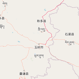
Map view of Sanjiangyuan National Park

Use this park location map to pinpoint Sanjiangyuan National Park in China, understand its exact geographic position, and read its mapped placement within the surrounding landscape more clearly.

Pigeon | © OpenStreetMap contributors

Location context for Sanjiangyuan National Park

Qinghai
Recorded earthquake history

Review the Historical Earthquake Catalogue for Sanjiangyuan National Park

Explore the documented history of seismic events associated with the geography of Sanjiangyuan National Park. This MoriAtlas catalogue provides a clear, data-driven view of recorded epicentres and magnitudes to help deepen understanding of the regional terrain's historical seismic context.

Sanjiangyuan National Park Earthquake History

Catalogued events

809 events

Strongest magnitude

Magnitude 7.3

Most recent event

Aug 6, 2026

This history includes earthquakes recorded inside the park or within 50 km of its borders

Gain visual insight into the park's distinct terrain, alpine wetlands, and critical river headwater environments across the vast Tibetan Plateau.

Sanjiangyuan National Park Photos: Alpine Landscapes and River Headwater Scenery

Explore Sanjiangyuan National Park's vast alpine landscapes, from unique high-altitude wetlands and expansive grasslands to the rugged mountain ranges of the Tibetan Plateau. View imagery for crucial insights into the park's protected-area character, revealing critical river headwaters and habitats for endangered species such as the snow leopard, enhancing conservation understanding.

Stone marker with Chinese text and English translation for Three River Source National Park and Qinghai Kekexili World Heritage Site against blue sky

Park atlas

Compare adjacent protected areas, trace their mapped geography, and explore the connected alpine ecosystems of the Tibetan Plateau region.

Explore More National Parks and Protected Areas Around Sanjiangyuan National Park on the Tibetan Plateau

Continue your park discovery beyond Sanjiangyuan National Park by browsing a curated list of nearby national parks and related protected areas. This structured geographic atlas helps you compare high-altitude landscapes and understand the regional conservation efforts across the vast Tibetan Plateau.
Nature reserveTibet Autonomous Region
Park boundaries overlap#1 closest

Southwest

Qiangtang National Nature Reserve: Regional Geography and Protected Alpine Steppe Boundaries

High-altitude wilderness and alpine wildlife refuge in Tibet

Covering hundreds of thousands of square kilometers of the northern Tibetan Plateau, Qiangtang National Nature Reserve forms a core protected landscape of immense scale. Its terrain is defined by sweeping high-altitude plains, low mountain ranges, and numerous scattered lakes that create a unique and harsh environment. The area remains a globally significant stronghold for native Tibetan species and demonstrates the complex geographic character of the region.

Area
334,000 km²
Established
1993
IUCN
VI
Relief
Highland
Wildlife reserveArunachal Pradesh
About 286 km away#2 closest

South

Dibang Wildlife Sanctuary: Protected Landscape and Geography in Arunachal Pradesh

A vast eastern Himalayan wildlife reserve in the Mishmi Hills

Located in the Upper Dibang Valley, this wildlife reserve occupies an expansive mosaic of montane forests and steep gorges. As a key segment of the Dihang-Dibang Biosphere Reserve, the sanctuary provides vital habitat continuity across elevation gradients ranging from river valleys to high temperate slopes, forming a major unit of protected land in the Indian Himalayas.

Area
4,149 km²
Established
1992
IUCN
IV
Relief
Mountain
Wildlife reserveArunachal Pradesh
About 301 km away#3 closest

South

Yordi Rabe Supse Wildlife Sanctuary: Protected Forest Landscapes and Himalayan Geography

A detailed map and atlas overview of West Siang district terrain

Spanning elevations between 1,500 and 2,500 meters, this wildlife reserve in Arunachal Pradesh acts as a crucial refuge for high-altitude ungulates and rare mammals. The sanctuary offers a unique look at continuous vegetation gradients ranging from tropical canopy to coniferous pine forest, defining the ecological character of this eastern Himalayan mountainous region.

Area
397 km²
Established
1996
IUCN
IV
Relief
Mountain
National parkSichuan
351 km away#4 closest

East

Jiuzhaigou National Park: Mapped Geography and Protected Area Overview in Sichuan, China

Travertine terrace systems and high mountain forest landscapes

Located on the edge of the Qinghai-Tibet Plateau, Jiuzhaigou is a protected landscape characterized by a network of clear alpine lakes known as haizi and extensive coniferous forest blocks. The park showcases a rare interplay of water and mineral-rich rock, creating expansive travertine dams and cascading waterfalls across its three main gullies. This atlas entry focuses on the regional geography, habitat distribution, and natural terrain that constitute the essential character of this prominent conservation area within the Min Mountains.

Area
720 km²
Established
1978
Relief
Mountain
Climate
Alpine
National parkArunachal Pradesh
About 356 km away#5 closest

South

Mouling National Park: Explore Arunachal Pradesh National Park Geography and Protected Landscape

Mapped protected areas and regional geographic context.

Mouling National Park in Arunachal Pradesh offers a unique opportunity to explore the mapped boundaries and geographic characteristics of a significant protected landscape. This page provides structured insights into its role as a national park, detailing its regional setting and contributing to a broader atlas of protected areas. Understand the distinct natural terrain and landscape context that define this protected area within India.

Area
483 km²
Established
1986
IUCN
II
Relief
Mountain
Protected areaSichuan
364 km away#6 closest

East

Huanglong Scenic and Historic Interest Area: Protected Alpine Landscapes and Travertine Map

High-altitude karst geography in the Minshan Mountains of Sichuan

Huanglong Scenic and Historic Interest Area presents a unique geological profile centered on a long valley of stepped travertine pools that cascade through alpine forests and meadows. This protected area offers a distinct look at the high-mountain geography of Sichuan, providing a clear view of how mineral-rich springs, deep canyons, and glaciated summits create a layered and ecologically significant environment for rare wildlife.

Area
600 km²
Established
1992
Nature reserveTibet Autonomous Region
About 369 km away#7 closest

Southwest

Laru Wetland National Nature Reserve: Mapped Geography and Protected Plateau Landscapes

High-altitude urban marshlands in the Tibet Autonomous Region

Laru Wetland National Nature Reserve is defined by its expansive reed and peat marsh habitats located at an elevation of over 3,600 meters. As the largest natural wetland within a city globally, it acts as a critical hydrological basin for the Lhasa region. The reserve offers detailed insight into plateau birdlife habitats, including populations of black-necked cranes, and illustrates the complex relationship between seasonal river systems and urbanized Tibetan geography.

Area
6.2 km²
Established
1999
Relief
Upland
Climate
Alpine
National parkChina
373 km away#8 closest

East

Giant Panda National Park: China's Premier Panda Habitat and Protected Landscape

Mapped terrain and conservation significance in the mountains of western China.

Giant Panda National Park is a critically important protected area in China, established to conserve the primary habitat for the giant panda. This national park, spanning a vast mountainous region across Sichuan, Gansu, and Shaanxi, integrates numerous former reserves into a unified landscape. It serves as a vital sanctuary, protecting approximately 80 percent of the world's wild panda population and offering deep insights into the geographic distribution and ecological requirements of these endangered animals.

Area
27,134 km²
Established
2020
IUCN
II
Relief
Mountain

Common questions about visiting, size, designation, and location context for Sanjiangyuan National Park

Sanjiangyuan National Park FAQs for park facts, access, geography, and protected area context

Find quick answers about Sanjiangyuan National Park, including protected-area facts, park geography, trail and visitor context, and how the park fits into its surrounding country and regional landscape.
MoriAtlas Explorer

Continue Your Protected Areas Search Across the Global Atlas

Deepen your exploration by continuing the structured search for national parks and protected areas worldwide. Utilize the comprehensive filtering capabilities to compare different conservation landscapes and refine your understanding of global park geography. Discover more about the distribution and characteristics of protected natural areas.

Global natural geography