
Mori Atlas logo
Nature reserveSchwarzbachtal (PB)

Understanding the mapped boundaries and valley habitats of this Paderborn district nature reserve

Schwarzbachtal (PB) Nature Reserve and Protected Stream Valley Landscape Geography

(Naturschutzgebiet Schwarzbachtal (PB))

Schwarzbachtal (PB) serves as a protected nature reserve in the North Rhine-Westphalia region, centered on the distinct stream valley corridor of the Schwarzbach. Established with a long history of conservation, this area features diverse valley habitats and riparian landscapes that provide a managed ecological transition between local terrain and regional geography. Our atlas records reveal the specific boundaries and environmental context that define this habitat and species management area.

nature reservestream valleyriparian habitatvalley landscapehabitat managementIUCN Category IV
Digital illustration of a forested valley with tree stumps in the foreground, a winding stream in the midground, and a waterfall cascading down rocky mountains in the background under a setting sun.

Schwarzbachtal (PB)

Nature reserve

Park overview

Structured park overview, official facts, and landscape profile for Schwarzbachtal (PB)

Schwarzbachtal (PB) park facts, protected area profile, and essential visitor context

Review the core facts for Schwarzbachtal (PB), including designation, size, terrain, visitor scale, habitats, and operating context in one park-focused overview.

About Schwarzbachtal (PB)

Schwarzbachtal (PB) is a nature reserve in the eastern part of North Rhine-Westphalia, within the Paderborn district. It lies on the territory of the town of Lichtenau, southeast of the town's central area and northeast of the Blankenrode district. The protected area follows the valley of the Schwarzbach, a small stream that shapes the local topography and gives the reserve its name.

The reserve's character is defined by the valley landscape it preserves, combining the stream corridor with the slopes, woodland, and associated habitat transitions typical of small river valleys in this part of Westphalia. This setting gives the area both visual landscape value and ecological importance as a connected natural corridor along the watercourse.

Administratively, the reserve is one of several Naturschutzgebiete located within Lichtenau and is part of the wider system of protected areas in the Paderborn district. Its current configuration dates from 2014, when the landscape plan for Lichtenau came into force, formalizing the reserve under its present key number PB-021. The original 1942 protection order covered a much larger area that extended across the districts of Paderborn and Höxter and into the city of Bielefeld. Today, the Lichtenau portion forms an independent designation within this historical framework.

The site is classified under IUCN Category IV as a Habitat/Species Management Area, which signals its primary function in supporting targeted habitat and species protection rather than strict wilderness conservation. This classification reflects the reserve's role in maintaining ecological quality within a managed, inhabited landscape, including areas near major transport infrastructure such as the A 44 motorway to the southwest and the B 68 federal road to the east.

Quick facts and research context for Schwarzbachtal (PB)

Schwarzbachtal (PB) is a nature reserve (Naturschutzgebiet) situated in Lichtenau, within the Paderborn district of North Rhine-Westphalia, Germany. It lies along the Schwarzbach stream and has carried protected status since 1942. The reserve is identified by the key number PB-021 and covers about 220 hectares within the Lichtenau municipal area. It is classified as an IUCN Category IV protected area, reflecting its role as a habitat and species management zone.

Protection and recognition

Examine the verified conservation framework and international database records for Schwarzbachtal (PB).

Schwarzbachtal (PB) Protection Status and Protected Area Designation Record

Comprehensive protected area designation data highlights the documented conservation framework established for Schwarzbachtal (PB). Official database records outline the administrative classification and verified status parameters associated with this protected landscape.

Protection details

WDPA ID
349938
Park context

Deeper park guide and search-rich context for Schwarzbachtal (PB)

Schwarzbachtal (PB) history, landscape, wildlife, and travel context

Explore Schwarzbachtal (PB) through its history, landscape character, ecosystems, wildlife, conservation priorities, cultural context, and seasonal travel timing in a structured park guide built for atlas discovery and search intent.

Why Schwarzbachtal (PB) stands out

Schwarzbachtal (PB) is best known for being a long-established nature reserve protecting a stream valley landscape in the Paderborn district. Its defining character lies in the protected stretch of the Schwarzbach and its associated valley habitats, which have been under conservation management since the early 1940s. The reserve is also notable for being part of a broader historical Schutzgebiet complex that originally spanned parts of three administrative regions before being divided into more localized designations.
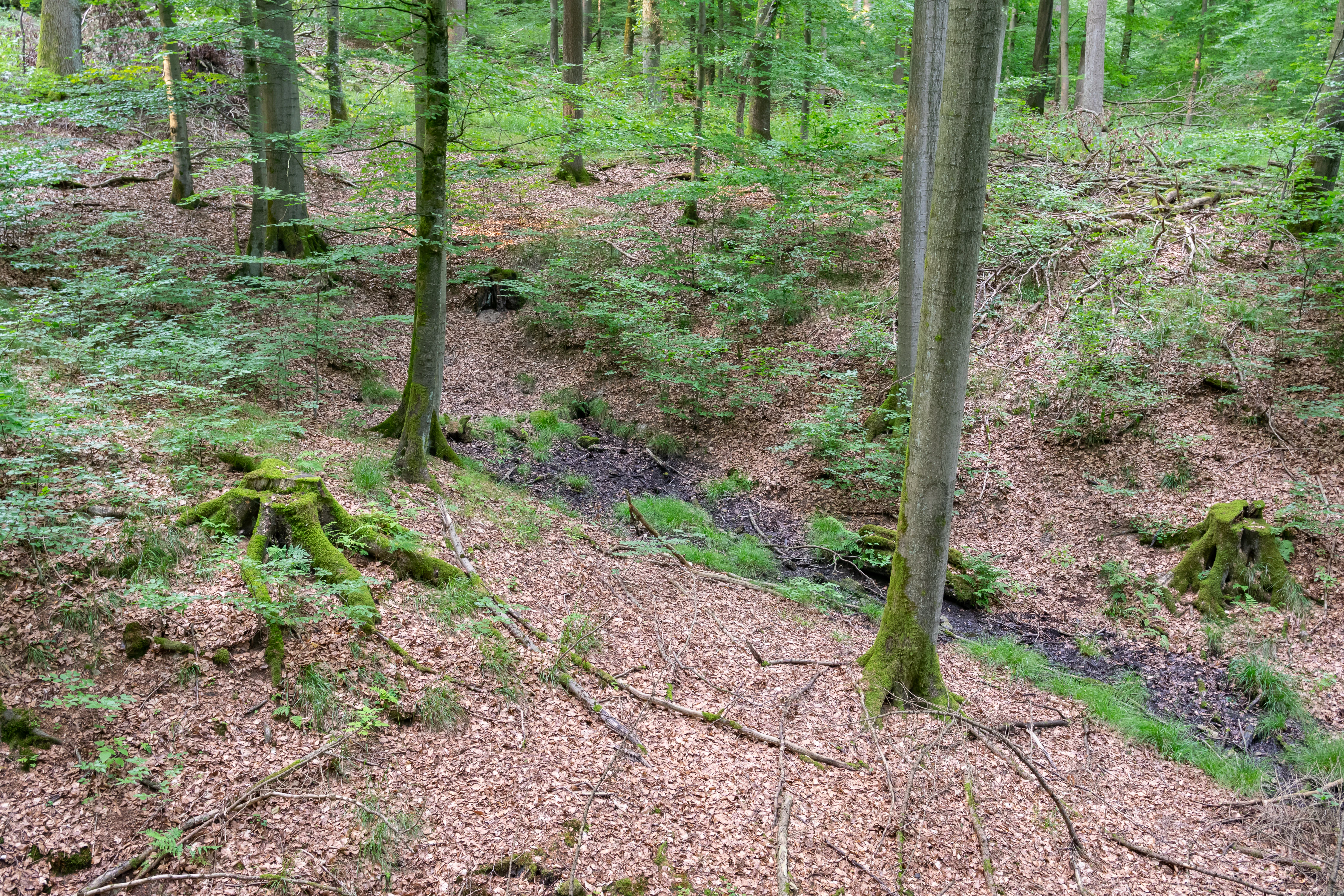
A small, narrow stream flows through a lush, deciduous forest with mossy tree stumps and a leaf-covered forest floor.
A shaded stream winding through the forest floor of the Schwarzbachtal nature reserve.

Schwarzbachtal (PB) history and protected-area timeline

The Schwarzbachtal was first placed under nature protection in 1942, making it one of the older nature reserves in the Paderborn district of North Rhine-Westphalia. At the time of its original designation, the protected area was significantly larger, covering approximately 511 hectares that extended across the districts of Paderborn and Höxter and into the city of Bielefeld.

Following the administrative reform of the original designation, the protection order was renewed in 2002 through a regulation issued by the regional government (Bezirksregierung). This renewal formalized the conservation framework but did not immediately redefine the local compartments of the reserve.

In 2014, the entry into force of the Lichtenau municipal landscape plan brought a clearer administrative identity to the portion of the reserve lying within Lichtenau. From that point, this section has carried the key number PB-021 and an area of approximately 220 hectares, distinguishing it as the Schwarzbachtal (PB) unit within the broader historical Schutzgebiet.

Schwarzbachtal (PB) landscape and geographic character

The landscape of Schwarzbachtal (PB) is shaped by the valley of the Schwarzbach, a minor stream that gives the protected area its defining character. The reserve extends along this stream corridor southeast of Lichtenau's town center and northeast of Blankenrode, occupying the natural low point between the surrounding higher ground.

The terrain follows a typical Westphalian valley pattern, with the stream course at the base and rising slopes on either side that carry woodland and edge habitats. This configuration creates transitions between wetter, near-stream environments and the drier vegetation of the upper slopes, giving the reserve a layered landscape structure within a relatively compact area.

The wider setting of the reserve is bordered by transport infrastructure, with the A 44 motorway running to the southwest and the B 68 federal road to the east. Despite this proximity to major routes, the valley itself retains a quiet, contained character that distinguishes it from the surrounding open countryside.

Schwarzbachtal (PB) ecosystems, habitats, and plant life

Schwarzbachtal (PB) protects a stream valley ecosystem in which the central feature is the course of the Schwarzbach and the habitats that develop along and around it. The reserve's natural value is closely tied to the presence of flowing water, which supports riparian vegetation, moist woodland communities, and the transitions between aquatic and terrestrial environments that are characteristic of small valleys in this part of North Rhine-Westphalia.

The reserve functions as part of the broader ecological network of protected valley habitats in the Paderborn district. Its position within Lichtenau links it with a series of neighboring nature reserves, contributing to a regional mosaic of protected stream valleys, woodlands, and slope habitats.

As a Habitat/Species Management Area under IUCN Category IV, the reserve is managed with an emphasis on maintaining and improving the ecological conditions of these valley habitats. The site is not designated for wilderness preservation but rather for targeted stewardship of the habitats and species that depend on the stream valley environment.

Schwarzbachtal (PB) conservation status and protection priorities

The principal conservation significance of Schwarzbachtal (PB) lies in its long history of formal protection, dating back to 1942. This makes it a long-standing component of the nature conservation network in the Paderborn district and gives it an established role within regional habitat protection efforts. The persistence of protected status across more than eight decades reflects its recognized value as a stream valley habitat.

The reserve is classified under IUCN Category IV as a Habitat/Species Management Area, a designation that emphasizes its role in supporting habitat quality and species populations rather than preserving untouched natural conditions. This positioning is consistent with the reserve's character as a working conservation area within a landscape that includes nearby towns, roads, and agricultural land.

In its current form, defined under the Lichtenau landscape plan of 2014 and carrying key number PB-021, the reserve represents the Lichtenau portion of a historical Schutzgebiet that once extended more broadly across Paderborn, Höxter, and Bielefeld. Its present configuration gives it a clear administrative identity and ensures its continued integration into the formal conservation planning of the municipality and the district.

Top sights and standout views in Schwarzbachtal (PB)

Schwarzbachtal (PB) stands out for its combination of long-protected status, well-defined valley character, and clear administrative identity. The reserve's 1942 designation places it among the older nature reserves in the Paderborn district, and its 2014 redefinition under the Lichtenau landscape plan gives it a modern, formally integrated conservation role.

The valley of the Schwarzbach provides the reserve with a clear ecological focus, distinguishing it from the surrounding agricultural and settlement landscape. Its IUCN Category IV status reflects a deliberate approach to habitat and species management, fitting its position between protected wilderness and intensively used land.

Monthly climate preview

Measured monthly temperature ranges and precipitation averages at a representative coordinate

Schwarzbachtal (PB) Climate Normals and Long Term Temperature Rhythms

Representative point records outline the annual temperature progression and daily precipitation rates measured across the protected valley. Complete monthly climate normals reveal detailed twelve month averages for temperature and precipitation.
Annual mean9 °C
0 °C18 °C
Jan
Feb
Mar
Apr
May12°
Jun15°
Jul18°
Aug18°
Sep14°
Oct
Nov
Dec
Warmest month
July

18 °C

Coolest month
January

-0.2 °C

Wettest month
July

2.6 mm/day

Driest month
April

1.7 mm/day

Park location guide

Geography guide, regional context, and park location map for Schwarzbachtal (PB)

Schwarzbachtal (PB) park geography, regions, and map view in Germany

Understand where Schwarzbachtal (PB) sits in Germany through a broader geographic reading of the surrounding landscape, nearby location context, and its mapped position within the national park landscape.

How Schwarzbachtal (PB) fits into Germany

Germany is a federal republic in Western and Central Europe with a population of over 83 million across sixteen constituent states. It is Europe's largest economy by nominal GDP and a major global exporter and importer. The capital is Berlin, and the country borders Denmark, Poland, Czech Republic, Austria, Switzerland, France, Luxembourg, Belgium, and the Netherlands.

Wider geography shaping Schwarzbachtal (PB) in Germany

Germany is located in Western and Central Europe, spanning 357,022 km². It borders Denmark to the north, Poland and the Czech Republic to the east, Austria and Switzerland to the south, and France, Luxembourg, Belgium, and the Netherlands to the west. The country has coastlines on the Baltic Sea and North Sea to the north, with the Alps located in the southern region.

Map view of Schwarzbachtal (PB)

Use this park location map to pinpoint Schwarzbachtal (PB) in Germany, understand its exact geographic position, and read its mapped placement within the surrounding landscape more clearly.

Pigeon | © OpenStreetMap contributors

Location context for Schwarzbachtal (PB)

North Rhine-Westphalia

Visual reference collection highlighting stream corridors and riparian habitats.

Schwarzbachtal (PB) Photos and Protected Valley Landscape Scenery

Visual documentation of Schwarzbachtal (PB) reveals the distinct topography and stream-carved terrain defining this protected nature reserve. Photographic records of the valley environment help researchers and visitors interpret local habitat management patterns across the Westphalian landscape.

A small, narrow stream flows through a lush, deciduous forest with mossy tree stumps and a leaf-covered forest floor.

Park atlas

Compare adjacent valley habitats and regional nature reserves across North Rhine-Westphalia

Explore Parks Near Schwarzbachtal (PB) and Surrounding Protected Landscapes

Visitors exploring Schwarzbachtal (PB) can browse adjacent stream valley reserves and connected protected landscapes throughout the Paderborn district. Comparing nearby protected areas reveals regional habitat patterns and broader conservation networks across the surrounding hill country.
A horizontal watercolor painting showing a soft landscape with a winding stream, grassy meadows, and distant forested hills under a pale sky.
Nature reserveGermany
About 4.3 km away#1 closest

West

Marschallshagen und Nonnenholz mit oberem Altenautal Protected Nature Reserve Map

Ecological landscape and forest geography in the Paderborn district

Covering approximately 1,943 hectares, this nature reserve is a major component of the regional conservation framework. The landscape creates a layered mosaic of closed beech forest, near-natural running water, and floodplain woodland, serving as a significant site for European bird protection programs.

Area
19.43 km²
Established
2002
A soft watercolor painting showing a panoramic view of rolling hills and undulating green and pink landscape features against a pale sky.
Nature reserveWaldeck-Frankenberg
About 7.4 km away#2 closest

South

Naturschutzgebiet Büchenberg und Platzberg bei Hesperinghausen: Geography and Protected Landscapes

A study of limestone slopes and calcareous grassland habitats

This protected area in Waldeck-Frankenberg serves as a key site for calcareous dry grasslands and rare orchid species. The terrain features a striking mosaic of steep Zechstein limestone slopes, rock outcrops, and moisture-rich meadow patches. Analyzing the area reveals how small, traditionally managed reserves can maintain high biodiversity and provide essential connectivity within the Diemeltal regional landscape.

Area
0.418 km²
Established
1993
Relief
Upland
Climate
Temperate
Watercolor illustration of rolling green and pink-tinted hills with scattered small trees against a white background.
Nature reserveNordrhein-Westfalen
About 11 km away#3 closest

Northeast

Kalktriften Willebadessen Nature Reserve: Mapped Geography and Protected Limestone Grasslands

Protected calcareous slopes within the Nethe valley region

Kalktriften Willebadessen encompasses a unique Muschelkalk limestone ridge in the Weser Uplands. This protected nature reserve provides a essential habitat for threatened flora and fauna, thriving within an open, sun-baked landscape that contrasts sharply with the surrounding forests. The site serves as a key example of how historical agricultural practices sustain biodiversity, featuring varied terrain from steep southern spurs to panoramic valley overlooks.

Area
1.12 km²
Established
2003
IUCN
IV
Relief
Upland
A soft watercolor illustration of rolling green hills, a cluster of trees, and distant low mountains in muted pastel tones.
Protected landscapeHochsauerlandkreis
About 13 km away#4 closest

South

Landschaftsschutzgebiet Freiflächen um Erlinghausen / Auf der Sandkuhle: Protected Area Map

A regional landscape conservation zone in Hochsauerlandkreis

This protected landscape encompasses 548 hectares of rural terrain surrounding Erlinghausen. It is defined by its traditional agricultural matrix, orchard meadows, and cultural heritage features that maintain the historic character of the eastern Sauerland foothills.

Area
5.487 km²
Established
2008
Relief
Upland
Scope
Terrestrial
A soft, horizontal watercolor painting showing a winding stream flowing through a green valley with gentle hills and trees in the background.
Nature reserveNordrhein-Westfalen
About 13 km away#5 closest

North

Naturschutzgebiet Schmittwassertal: A Protected Nature Reserve in the Paderborn District

Mapping brook corridors and calcareous grassland landscapes in Westphalia.

Naturschutzgebiet Schmittwassertal represents a fragmented yet ecologically vital nature reserve in Nordrhein-Westfalen. The area encompasses 53.6 hectares of stream-cut valleys and limestone-influenced slopes. This atlas entry details the mosaic of habitats ranging from alder-lined brook corridors to nutrient-poor Borstgrasrasen and semi-dry calcareous grasslands, highlighting its function as a connected biological corridor.

Area
0.536 km²
Established
2014
Relief
Upland
Climate
Temperate
A soft watercolor painting of a serene landscape featuring a small pond in the foreground with gentle hills and trees in the background.
Protected landscapeKreis Paderborn
About 14 km away#6 closest

Northwest

Landschaftsschutzgebiet Büren: A Detailed Look at the Protected Rural Mosaic of Kreis Paderborn

Mapped protected landscapes in the German Westphalian countryside

Landschaftsschutzgebiet Büren spans a wide, undulating terrain in the Kreis Paderborn district, characterized by its durable structure of woodland patches, hedgerows, and headwater springs. The area serves as a key case study in maintaining semi-natural ecological features within an active, working agricultural landscape. Access detailed geographic context on the patterns of this regional protected area and its role in the Westphalian landscape.

Area
142.95 km²
Established
1974
Relief
Mixed relief
Scope
Terrestrial
A horizontal watercolor painting of a calm lake surrounded by a pine forest and rolling hills under a soft light.
Protected landscapeKreis Paderborn
About 15 km away#7 closest

Southwest

Landschaftsschutzgebiet FFH-Gebiet Fürstenberger Wald: Protected Area and Forest Geography

A woodland conservation landscape in the Kreis Paderborn foothills

This protected area features a cohesive block of old-growth beech forest, enriched by significant deadwood habitats and a dense internal network of brooks. Located within the Kreis Paderborn administrative district, the landscape serves as a key ecological connector in the eastern Sauerland, balancing moist valley meadows with upland forest ridges and ongoing deciduous forest restoration efforts.

Area
14.925 km²
Established
2007
Relief
Upland
Climate
Temperate
Watercolor painting of a wide, soft-toned landscape showing gentle rolling hills, open fields, and a small meandering stream, executed in a minimalist, light-filled style.
Protected landscapeHochsauerlandkreis
About 17 km away#8 closest

Southwest

Landschaftsschutzgebiet Freiflächen um Giershagen: Protected Landscape and Regional Map

Agricultural cultural heritage and biodiversity in Hochsauerlandkreis

This protected area in North Rhine-Westphalia preserves 785 hectares of traditional Sauerland countryside. It features extensively managed farmland, rare arable plant habitats, and historically significant landscape structures that support regional biodiversity and long-term ecological stewardship.

Area
7.849 km²
Established
2008
Relief
Upland
Scope
Terrestrial

Common questions about visiting, size, designation, and location context for Schwarzbachtal (PB)

Schwarzbachtal (PB) FAQs for park facts, access, geography, and protected area context

Find quick answers about Schwarzbachtal (PB), including protected-area facts, park geography, trail and visitor context, and how the park fits into its surrounding country and regional landscape.
MoriAtlas Explorer

Continue Your Protected Areas Search Across the Global Atlas

Deepen your exploration by continuing the structured search for national parks and protected areas worldwide. Utilize the comprehensive filtering capabilities to compare different conservation landscapes and refine your understanding of global park geography. Discover more about the distribution and characteristics of protected natural areas.

Global natural geography