

Mori Atlas logo
Nature reserveSchwarzwald

Mapping the alluvial forests, oxbows, and river dynamics of this Rhineland-Palatinate sanctuary

Schwarzwald Nature Reserve: A Detailed Geographic Atlas of Rhine Floodplain Protected Landscapes

(Naturschutzgebiet Schwarzwald)

Schwarzwald serves as a vital protected nature reserve within the Rhineland-Palatinate region, showcasing the complex geography of the Upper Rhine Plain. Located between the active Rhine channel and the historic Lingenfelder Altrhein oxbow, this landscape preserves a rare mosaic of softwood alluvial forests, hardwood stands, and gravel pit lakes. This atlas entry provides a structured perspective on the floodplain terrain, revealing how water-influenced landforms and sediment deposition shape this protected environment.

floodplain forestalluvial woodlandUpper RhineRhineland-Palatinatenature reserveoxbow

Schwarzwald

Nature reserve

Park overview

Structured park overview, official facts, and landscape profile for Schwarzwald Nature Reserve

Schwarzwald Nature Reserve park facts, protected area profile, and essential visitor context

Review the core facts for Schwarzwald Nature Reserve, including designation, size, terrain, visitor scale, habitats, and operating context in one park-focused overview.

About Schwarzwald Nature Reserve

Schwarzwald Nature Reserve is a regionally important protected area in the Upper Rhine Plain of Rhineland-Palatinate, dedicated to preserving the ecological character of the Rhine floodplains. Although the name literally means "Black Forest," the reserve has no relation to the well-known Black Forest mountain range in Baden-Württemberg. Here, "Schwarzwald" refers instead to a dark, dense stretch of floodplain woodland, an association that reflects the deep shade and thick vegetation typical of alluvial forests along large lowland rivers.

The reserve is located between the present-day Rhine channel and the older Lingenfelder Altrhein, an oxbow arm that records a former course of the river. This pairing of an active river and a former course is characteristic of the Upper Rhine, where straightening, diking, and the construction of shipping channels have left behind a network of Altrhein waters and floodplain remnants. By protecting both the wet woodland and the open-water features of this corridor, the reserve maintains a relatively continuous ecological gradient from dry gravel bars to permanently waterlogged forest soils.

Designated under a Rhineland-Palatinate nature conservation ordinance dated 4 March 1997, the area covers approximately 340.97 hectares across the municipalities of Lingenfeld and Mechtersheim, the latter now part of the municipality of Römerberg. The reserve includes zones of extensively used meadows, old-growth stands, pollarded willows, and a range of floodplain water bodies, including gravel pit lakes and side channels (Schluten) that branch off the main water features. These landscape elements together illustrate how Rhine floodplains functioned before large-scale regulation, and they continue to support characteristic bird, fish, amphibian, and insect communities typical of lowland river systems in central Europe.

Quick facts and research context for Schwarzwald Nature Reserve

Schwarzwald Nature Reserve is located in Rhineland-Palatinate, Germany, and spans parts of the Landkreis Germersheim and Rhein-Pfalz-Kreis. It covers approximately 341 hectares and was formally designated as a nature reserve in March 1997. The protected area lies on the Gemarkung of Mechtersheim (part of the municipality of Römerberg) and on the municipality of Lingenfeld, bordered by the mainstream Rhine to the southeast and the Lingenfelder Altrhein to the southwest.

The reserve preserves Rhine floodplain landscapes that include alluvial softwood and hardwood forests, pollarded willows, old-growth stands, extensively managed meadows, oxbow channels, gravel pit lakes, sand and gravel flats, reedbeds, and tall herb vegetation. Its primary significance lies in maintaining a connected mosaic of wet woodland and open floodplain habitats in an otherwise heavily modified stretch of the Upper Rhine.

Protection and recognition

Examine the verified conservation metrics and designation records for Schwarzwald.

Schwarzwald Protection Status and Official Conservation Recognition Data

Schwarzwald holds recorded protection parameters and verified database metrics within global conservation registries. Official designation context provides structured insight into the legal framework governing this protected terrain.

Protection details

WDPA ID
165516
Park context

Deeper park guide and search-rich context for Schwarzwald Nature Reserve

Schwarzwald Nature Reserve history, landscape, wildlife, and travel context

Explore Schwarzwald Nature Reserve through its history, landscape character, ecosystems, wildlife, conservation priorities, cultural context, and seasonal travel timing in a structured park guide built for atlas discovery and search intent.

Why Schwarzwald Nature Reserve stands out

Schwarzwald is best known for its protected Rhine floodplain woodlands and its position between the active river channel of the Rhine and the historic Lingenfelder Altrhein oxbow. The reserve's defining feature is the combination of dynamic, water-influenced habitats in close proximity: softwood floodplain forest on frequently flooded sites, hardwood stands on higher, less frequently inundated terraces, and a network of still-water and open-ground features such as the Altrhein, gravel pit lakes, and exposed sand and gravel banks. This habitat diversity makes the area a representative example of Upper Rhine alluvial landscapes that were once widespread but have become increasingly fragmented.
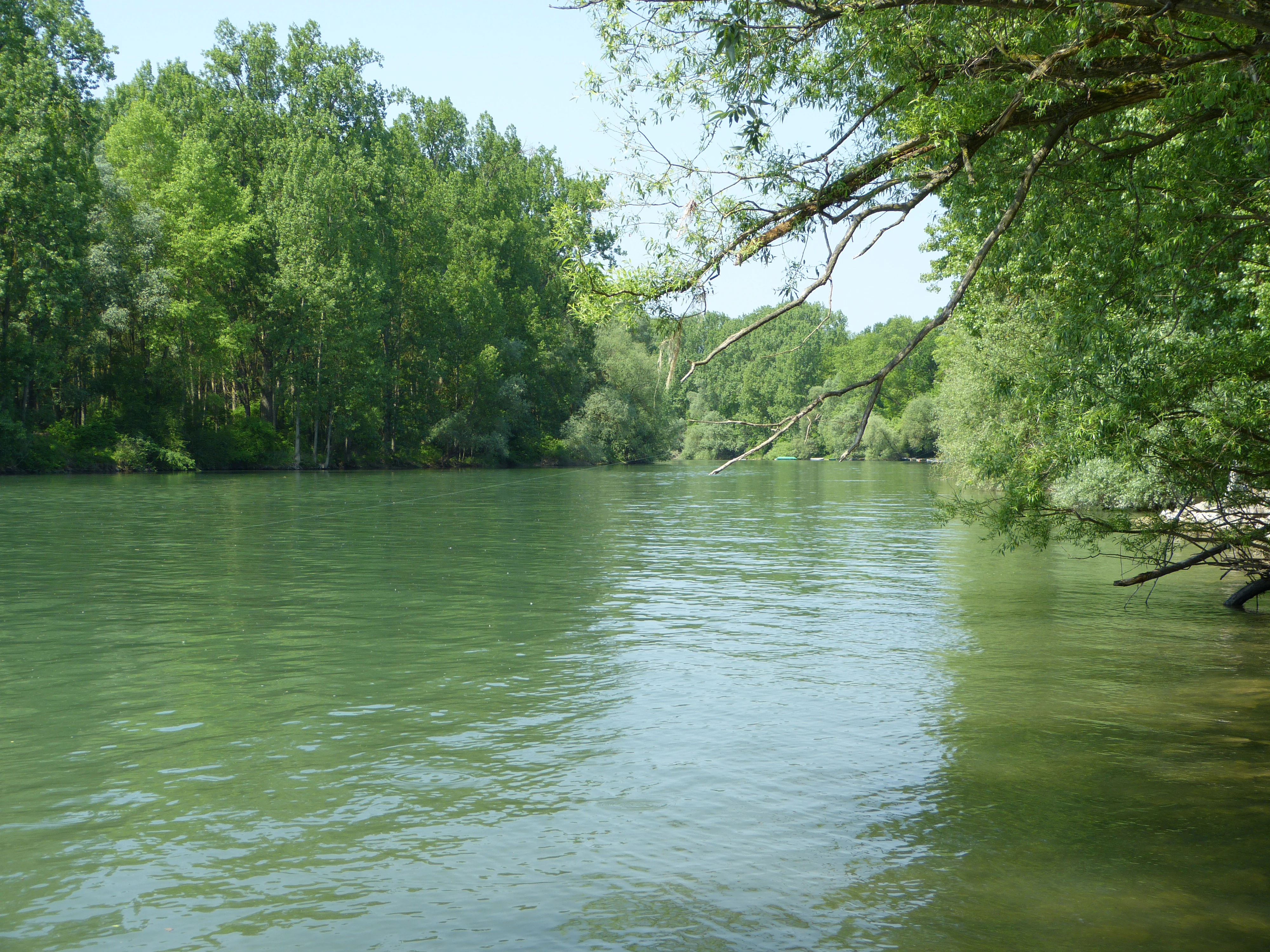
Altrhein in the Schwarzwald Nature Reserve near Mechtersheim
An old arm of the Rhine river located within the Schwarzwald nature reserve near Mechtersheim, Romerberg, in the Rhein-Pfalz-Kreis district.

Schwarzwald Nature Reserve history and protected-area timeline

Schwarzwald was placed under formal nature protection on 4 March 1997 through a state ordinance ("Rechtsverordnung über das Naturschutzgebiet Schwarzwald, Landkreise Ludwigshafen und Germersheim"), which defined its boundaries, extent, and protection objectives. The designation brought together existing floodplain woodland, meadows, and associated water bodies under a single legal framework.

The reserve's history is closely tied to centuries of landscape transformation along the Upper Rhine. The Lingenfelder Altrhein, which forms its southwestern edge, is itself a relic of a former river course that was cut off as the Rhine was progressively straightened, diked, and channelized for flood control and navigation, particularly during the nineteenth and twentieth centuries. The persistence of dense floodplain forest and meadow areas in this section made the site suitable for conservation at a time when much of the surrounding floodplain had been converted to farmland or settlement. The 1997 ordinance thus represents a deliberate effort to preserve one of the remaining ecological reference points of the historical Rhine floodplain landscape.

Schwarzwald Nature Reserve landscape and geographic character

The landscape of Schwarzwald is shaped almost entirely by the Rhine and its floodplain dynamics. The reserve lies on a low-relief section of the Upper Rhine Plain, where elevation differences are small and the dominant features are water, sediment, and vegetation rather than topography. The active Rhine forms the southeastern edge of the area, while the Lingenfelder Altrhein, an older arm of the river now functioning mainly as a still-water oxbow, defines the southwestern boundary.

Between these two water bodies stretches a mosaic of floodplain landforms characteristic of a large regulated lowland river. Substrate ranges from coarse gravel and sand on higher bars to finer silt and mud in quieter embayments. Gravel pit lakes (Kiesseen) mark former extraction sites that have since filled with water and become integrated into the floodplain mosaic. Side channels and sloughs (Schluten) cut across the floodplain, retaining water at varying levels throughout the year and providing a transitional habitat between open water and dense woodland.

The resulting terrain is a patchwork of wet woodland, open meadow, scrub, exposed sediment, and standing water. Softwood alluvial forest occupies the lowest, most frequently flooded depressions, while hardwood stands, old-growth trees, and pollarded willows occupy slightly higher terraces. This subtle gradient of flooding frequency is one of the defining landscape traits of the reserve.

Schwarzwald Nature Reserve ecosystems, habitats, and plant life

Schwarzwald protects a representative cross-section of Rhine floodplain ecosystems in a small but ecologically rich area. Its habitats span the full range of floodplain moisture conditions, from permanently waterlogged oxbow channels to dry gravel ridges that are only briefly submerged during major flood events.

The vegetation reflects the classic zonation of Central European lowland river floodplains. Softwood forests, dominated by willows and poplars adapted to regular flooding, occupy the lowest zones. Hardwood alluvial forest, including oak, ash, and elm, stands on higher terraces that are less frequently inundated. Old-growth stands and traditional pollarded willows add structural variety, creating standing dead wood, cavities, and open crowns that are valuable for woodland species.

Open habitats are equally important to the reserve's ecological identity. Extensively managed meadows provide grassland vegetation that depends on low-intensity traditional use. Exposed sand, gravel, and mud flats offer ephemeral habitat for pioneer plants and invertebrates, while reedbeds and tall-herb fringes (Hochstaudenfluren) line the watercourses and create dense vegetation along channel margins. Gravel pit lakes, the Altrhein itself, and smaller Schluten add further aquatic and semi-aquatic habitats, supporting submerged and floating vegetation communities characteristic of nutrient-rich lowland waters.

Schwarzwald Nature Reserve wildlife and species highlights

The mosaic of wet woodland, open water, reedbed, and meadow within Schwarzwald supports a rich and characteristic floodplain fauna. The combination of dense alluvial forest, quiet oxbow waters, gravel pit lakes, and open muddy or sandy shores provides feeding, breeding, and refuge habitats for a wide range of groups, from fish and amphibians to birds and insects typical of large lowland river systems.

The reserve's birdlife is particularly significant. Wooded shorelines, reedbeds, and open water offer habitats for waterfowl, waders, and riparian woodland species, while old trees and pollarded willows provide nesting cavities for hole-breeding birds. Exposed sand and gravel banks along the rivers and lakes are valuable for ground-nesting and resting birds during seasonal movements.

Fish communities reflect the connection of the reserve's waters to the Rhine, with species typical of lowland river systems present in both the Altrhein and adjacent gravel pit lakes. Amphibians benefit from the combination of standing water for breeding and structurally diverse terrestrial habitat along the forest edge. Invertebrates, including dragonflies, beetles, and other groups associated with floodplain woodlands, muddy banks, and temporary pools, thrive in the variety of microhabitats that the reserve maintains.

Schwarzwald Nature Reserve conservation status and protection priorities

Schwarzwald is significant from a conservation perspective as one of the remaining ecologically intact stretches of Rhine floodplain in a heavily modified section of the Upper Rhine. The reserve's protected status, established by the 1997 ordinance, was designed to preserve the integrity of interconnected floodplain habitats in an area where the surrounding landscape has been largely converted to agricultural and settlement use.

The conservation value of the reserve lies in its habitat diversity within a relatively compact area. Softwood and hardwood alluvial forest, extensive meadows, reedbeds, gravel pit lakes, the oxbow Altrhein, and open sediment flats together form a functional floodplain system that would be difficult to maintain in isolation. By keeping these elements under a single legal framework, the reserve sustains ecological processes such as natural regeneration of floodplain forest, seasonal flooding dynamics, and the exchange of species between aquatic and terrestrial habitats.

In the broader context of Rhineland-Palatinate's network of nature reserves (Naturschutzgebiete), Schwarzwald contributes to the protection of floodplain heritage along the Upper Rhine, alongside related protected areas such as the Lingenfelder Altrhein, Hördter Rheinaue, and other woodland and oxbow reserves in the same administrative region. Its designation reflects an effort to retain ecological functioning in landscapes shaped, and progressively simplified, by river regulation.

Schwarzwald Nature Reserve cultural meaning and human context

The cultural context of Schwarzwald is closely tied to the long history of human management of the Upper Rhine floodplain. The presence of old-growth trees and traditional pollarded willows (Kopfweiden) indicates a long-standing tradition of woodland and tree management, in which willows were periodically cut to produce withies and wood products while maintaining an open, light-flooded canopy.

The extensively used meadows within the reserve reflect traditional low-intensity grassland management, which has historically been an integral part of floodplain farming economies. Although the Rhine has been progressively straightened and diked since the nineteenth century, this stretch of floodplain retained enough of its original character to support ongoing traditional land use alongside natural processes.

The reserve's name, while geographically disconnected from the Black Forest region, reflects a long-standing local tradition of naming floodplain woodlands. The dense shade of alluvial forest, particularly in winter when bare branches and dark trunks dominate the view, has historically inspired the descriptive term "Schwarzwald." Today, the reserve stands as a partnership between traditional land management and ecological conservation, illustrating how cultural practices and natural floodplain dynamics can be maintained together.

Top sights and standout views in Schwarzwald Nature Reserve

Schwarzwald Nature Reserve stands out for its compact but complete representation of Upper Rhine floodplain habitats, including softwood and hardwood alluvial forest, traditional pollarded willows, extensively used meadows, reedbeds, gravel pit lakes, and the Lingenfelder Altrhein oxbow.

The reserve's defining strength is the close integration of active river, oxbow water, floodplain forest, and open sediment habitats within a single protected area. This mosaic supports characteristic floodplain birdlife, fish communities, and invertebrate groups while preserving the visual and ecological character of a Rhine floodplain that has otherwise been heavily altered by river engineering.

Best time to visit Schwarzwald Nature Reserve

Spring and early summer are typically the most rewarding periods to experience a floodplain reserve such as Schwarzwald, when extensive meadows are in bloom, reedbeds and tall-herb fringes reach their full height, and bird activity, including breeding and migration, is at its peak along watercourses and woodland edges.

Late summer and early autumn offer a different but equally valuable atmosphere, with mature floodplain foliage, lower water levels that expose sand and gravel banks, and visible concentrations of waterfowl and other birdlife on lakes and oxbows. Winter brings a quieter, more austere character, with bare deciduous trees revealing the structure of alluvial forest and open views across the floodplain; this season can also highlight why such areas have traditionally been described as dark woodlands.

Monthly climate preview

Long-term representative measurements illustrating monthly thermal and moisture variations

Schwarzwald Climate Normals, Annual Temperature and Precipitation Rhythms

Representative coordinate records show measured monthly temperature variations spanning subzero lows to warm highs alongside steady daily precipitation amounts. Exploring the complete twelve-month climatology profile reveals detailed thermal trends and moisture patterns across the protected terrain.
Annual mean10 °C
0 °C20 °C
Jan
Feb
Mar
Apr
May14°
Jun18°
Jul20°
Aug20°
Sep15°
Oct10°
Nov
Dec
Warmest month
July

20.4 °C

Coolest month
January

0.3 °C

Wettest month
July

2.2 mm/day

Driest month
April

1.4 mm/day

Park location guide

Geography guide, regional context, and park location map for Schwarzwald Nature Reserve

Schwarzwald Nature Reserve park geography, regions, and map view in Germany

Understand where Schwarzwald Nature Reserve sits in Germany through a broader geographic reading of the surrounding landscape, nearby location context, and its mapped position within the national park landscape.

How Schwarzwald Nature Reserve fits into Germany

Germany is a federal republic in Western and Central Europe with a population of over 83 million across sixteen constituent states. It is Europe's largest economy by nominal GDP and a major global exporter and importer. The capital is Berlin, and the country borders Denmark, Poland, Czech Republic, Austria, Switzerland, France, Luxembourg, Belgium, and the Netherlands.

Wider geography shaping Schwarzwald Nature Reserve in Germany

Germany is located in Western and Central Europe, spanning 357,022 km². It borders Denmark to the north, Poland and the Czech Republic to the east, Austria and Switzerland to the south, and France, Luxembourg, Belgium, and the Netherlands to the west. The country has coastlines on the Baltic Sea and North Sea to the north, with the Alps located in the southern region.

Map view of Schwarzwald Nature Reserve

Use this park location map to pinpoint Schwarzwald Nature Reserve in Germany, understand its exact geographic position, and read its mapped placement within the surrounding landscape more clearly.

Pigeon | © OpenStreetMap contributors

Location context for Schwarzwald Nature Reserve

Rhineland-Palatinate

Explore protected habitats, alluvial woodlands, and river scenery across the reserve.

Schwarzwald Photos and Landscape Imagery: Visualizing the Rhine Floodplain

Visual documentation provides clear insight into the complex mosaic of alluvial woodlands, oxbow waters, and exposed gravel bars defining the protected Rhine floodplain environment. Detailed photographic records reveal the subtle terrain variations and dynamic water-influenced habitats that characterize the protected area ecosystem.

Altrhein in the Schwarzwald Nature Reserve near Mechtersheim

Park atlas

Compare adjacent floodplain reserves and related regional habitats across the Upper Rhine

Exploring Other Parks Near Schwarzwald and Protected Areas in the Surrounding Region

Browsing other protected areas near Schwarzwald reveals broader ecological patterns across the Upper Rhine floodplain landscape. Continued geographic comparison helps trace similar alluvial woodlands, oxbow waters, and river habitats throughout the surrounding region.
Nature reserveRhineland-Palatinate
About 3.4 km away#1 closest

South

Brückenkopf Nature Reserve: An Atlas of Protected Floodplain Geography in Rhineland-Palatinate

Detailed mapping of rare wetland habitats and regional floodplain zones

Brückenkopf offers a unique look at small-scale habitat conservation in the Germersheim district. This nature reserve protects a vital fragment of the Upper Rhine floodplain, serving as a sanctuary for specific wetland flora and rare invertebrates. Gain a better understanding of its location between major infrastructure corridors and the river, marking it as a significant component of regional conservation strategy.

Area
0.357 km²
Established
1982
IUCN
IV
Relief
Lowland
Nature reserveRheinland-Pfalz
About 4.5 km away#2 closest

Northeast

Flotzgrün Nature Reserve: Protected Floodplain Landscapes and Rhine Geography in Rheinland-Pfalz

Mapping historical island creation and modern conservation polders

Flotzgrün serves as a compelling geographic entity within the Upper Rhine, functioning as both an active flood management polder and a protected riparian environment. This site offers insights into the intersection of 19th-century river straightening and modern ecological restoration, revealing a landscape defined by controlled wetlands, old river arms, and managed floodplain habitats.

Area
3.4 km²
Relief
Lowland
Scope
Terrestrial
Water
Major water bodies
Nature reserveLandkreis Germersheim
About 6.1 km away#3 closest

South

Hördter Rheinaue Nature Reserve: Landscape and Geographic Context in Landkreis Germersheim

Examining the hydrology and floodplain forest of the German Rhine.

Hördter Rheinaue serves as a critical node in the Palatinate Rhine floodplains, preserving a vast mosaic of willow and poplar forests alongside stable hardwood stands. Analyze the mapped terrain shaped by centuries of river activity, including the meandering Michelsbach and associated oxbow systems that define this essential protected corridor in western Germany.

Area
8.18 km²
Established
1966
IUCN
IV
Relief
Lowland
Nature reserveRhineland-Palatinate
About 6.5 km away#4 closest

Northeast

Speyerer Auwald Nature Reserve: Protected Alluvial Forest Geography in Rhineland-Palatinate

An essential Rhine valley floodplain and habitat mosaic

Located along the Upper Rhine, the Speyerer Auwald encompasses a vital protected landscape of alluvial forests, relic oxbows, and traditional meadows. This record traces the park boundaries, hydrological features, and the distinct ecological zones that make this floodplain forest a cornerstone of the regional geography in Rhineland-Palatinate.

Relief
Lowland
Climate
Temperate
Access
Easy access
Scope
Terrestrial
Protected areaRhineland-Palatinate
About 7.6 km away#5 closest

Northwest

Speyerer Wald: Protected Alluvial Forest and Inland Sand Dune Landscape

Regional geography and protected area context in Rhineland-Palatinate.

Speyerer Wald offers a look into the formation of Rhine Plain alluvial fans and the survival of forest ecosystems on poor, sandy soils. This protected expanse showcases the intersection of inland dunes, dry sand grasslands, and riparian stream corridors. It serves as a key case study in regional landscape evolution, highlighting how ice age deposits continue to dictate current habitat distribution and nature conservation priorities.

Established
1981
Relief
Lowland
Climate
Temperate
Access
Easy access
Nature reserveRhineland-Palatinate
About 8.4 km away#6 closest

Southwest

Bellheimer Wald: Protected Alluvial Forest and Inland Dune Geography in Germany

Nature reserve landscapes in Rhineland-Palatinate

Bellheimer Wald offers a window into the unique geography of the Upper Rhine Plain. This protected forest is characterized by its sandy alluvial soils and rare inland dune systems, forming a core component of the alluvial-fan woodland chain that spans the southern Palatinate and supports complex habitats for specialized flora and fauna.

Area
46.79 km²
Established
2000
IUCN
IV
Relief
Lowland
Nature reserveRheinland-Pfalz
About 11 km away#7 closest

Northwest

Lochbusch-Königswiesen Nature Reserve: Protected Wetland and River Floodplain Geography

A detailed look at regional floodplain mapping in Rheinland-Pfalz

Lochbusch-Königswiesen stands as a critical protected landscape within the Rhine lowlands of Rheinland-Pfalz. Centered on the Speyerbach river corridor, this nature reserve maintains rare lowland bog and wet meadow communities. Its structured boundaries demonstrate the persistence of floodplain geography in an intensively managed region, offering a distinct focus for those examining protected-area distribution in Germany.

Area
1.99 km²
Established
1983
Protected areaRhineland-Palatinate
About 12 km away#8 closest

Northeast

Angelhofer Altrhein: Protected Riparian Environment in Rhineland-Palatinate

Historic river oxbow, floodplain forests, and Natura 2000 habitats

Located in the heart of the Upper Rhine plain, the Angelhofer Altrhein constitutes an essential protected area known for its distinct floodplain meadow and forest ecosystems. This backwater environment, once a main channel of the Rhine, provides critical habitat for diverse species and serves as a natural contrast to the surrounding industrial and recreational landscapes of the region.

Relief
Lowland
Climate
Temperate
Access
Easy access
Scope
Terrestrial

Common questions about visiting, size, designation, and location context for Schwarzwald Nature Reserve

Schwarzwald Nature Reserve FAQs for park facts, access, geography, and protected area context

Find quick answers about Schwarzwald Nature Reserve, including protected-area facts, park geography, trail and visitor context, and how the park fits into its surrounding country and regional landscape.
MoriAtlas Explorer

Continue Your Protected Areas Search Across the Global Atlas

Deepen your exploration by continuing the structured search for national parks and protected areas worldwide. Utilize the comprehensive filtering capabilities to compare different conservation landscapes and refine your understanding of global park geography. Discover more about the distribution and characteristics of protected natural areas.

Global natural geography