
Mori Atlas logo
Wildlife reserveRéserve nationale de faune de Shepody

A detailed geographic study of coastal wetlands, tidal mudflats, and migratory bird habitats

Réserve nationale de faune de Shepody: Exploring the Protected Landscapes of the Bay of Fundy

Réserve nationale de faune de Shepody is a vital protected landscape situated along the northwestern shore of the Bay of Fundy in New Brunswick. This atlas entry examines the reserve through its distinct hydrological units, ranging from high-tide mudflats and gravel spits to freshwater wetlands and riverine estuaries. By analyzing its Carboniferous sandstone foundation and diverse coastal terrain, the data reveals the structural role this area plays within the broader maritime geography.

shoreshorebird refugemigratory shorebirdssemipalmated sandpiperBay of Fundysalt marshfreshwater wetland
A flat-style digital illustration depicting a valley with steep rocky cliffs, a winding river, a waterfall, and a coniferous forest in the foreground.

Réserve nationale de faune de Shepody

Wildlife reserve

Park overview

Structured park overview, official facts, and landscape profile for Shepody National Wildlife Area

Shepody National Wildlife Area park facts, protected area profile, and essential visitor context

Review the core facts for Shepody National Wildlife Area, including designation, size, terrain, visitor scale, habitats, and operating context in one park-focused overview.

About Shepody National Wildlife Area

Shepody National Wildlife Area is a federally protected landscape in southeastern New Brunswick that conserves some of the most ecologically productive coastal habitats along the upper Bay of Fundy. Created in 1980 under the Canadian Wildlife Service, the area combines three separate parcels of land and water into a single integrated refuge. The largest unit, the Germantown Marsh, sits inland along the Chipoudy River near Riverside-Albert, while two coastal units, New Horton and Mary's Point, line the tidal shoreline of Chignectou Bay.

The defining character of the wildlife area comes from the meeting of two ecological worlds. Saltwater from the Bay of Fundy, famous for having the highest tides on Earth, sweeps twice a day over the muddy intertidal flats of Mary's Point, depositing rich nutrients that fuel an astonishing density of invertebrates. Behind the beach, freshwater marshes and river channels sustain a quieter but equally important habitat, providing calm feeding and roosting areas for waterfowl and other wetland birds.

The area's value extends well beyond New Brunswick. Mary's Point has been recognized as a Ramsar Wetland of International Importance since 1982 and was added to the Western Hemisphere Shorebird Reserve Network for the Bay of Fundy just a few years later. In 2007, the entire wildlife area was integrated into the transition zone of the Fundy Biosphere Reserve, linking Shepody to one of Canada's flagship UNESCO-recognized regions for marine and coastal conservation.

Geologically, the reserve sits on Carboniferous sandstone bedrock, parts of which are fossil rich, containing preserved calamites and petrified tree trunks as well as deposits of albertite, the asphalt-like mineral once studied by Abraham Gesner, New Brunswick's first provincial geologist, in his pioneering work on kerosene. Sandstone from Mary's Point has even been used historically in construction, with some of it incorporated into Central Park's Bethesda Terrace in New York City.

Quick facts and research context for Shepody National Wildlife Area

Shepody National Wildlife Area lies in Albert County, New Brunswick, along the northern edge of Chignectou Bay, an arm of the Bay of Fundy, with Moncton as the nearest major city. The protected area covers approximately 10.7 square kilometers and is divided into three distinct units: the Germantown Marsh on the Chipoudy River, and the New Horton and Mary's Point units along the coastal strand. Mary's Point was designated a Ramsar Wetland of International Importance in 1982 and became part of the Western Hemisphere Shorebird Reserve Network for the Bay of Fundy in 1987. The entire wildlife area was included in the Fundy Biosphere Reserve's transition zone in 2007.

Protection and recognition

Documented management scope and conservation designations for Réserve nationale de faune de Shepody

Réserve nationale de faune de Shepody Protection Status and Recognition

Examine the documented protection status, management scope, and international recognition records established for Réserve nationale de faune de Shepody. Review structured conservation metrics and verified designation data assembled for this protected area.

Protection details

Protection scope
Mixed
Transboundary protection
No
WDPA ID
18191
Park context

Deeper park guide and search-rich context for Shepody National Wildlife Area

Shepody National Wildlife Area history, landscape, wildlife, and travel context

Explore Shepody National Wildlife Area through its history, landscape character, ecosystems, wildlife, conservation priorities, cultural context, and seasonal travel timing in a structured park guide built for atlas discovery and search intent.

Why Shepody National Wildlife Area stands out

Shepody is best known for the extraordinary autumn shorebird migration at Mary's Point, where the mudflats hold what is considered the world's highest density of Corophium volutator, a small burrowing amphipod that fuels huge flocks of migrating sandpipers. About three quarters of the entire population of semipalmated sandpipers, often estimated at around 300,000 birds, stop here to feed before continuing south. The area is equally recognized as one of the key protected salt marsh and freshwater wetland complexes on the upper Bay of Fundy, anchoring the international migratory bird network that includes the Ramsar-listed Mary's Point site.
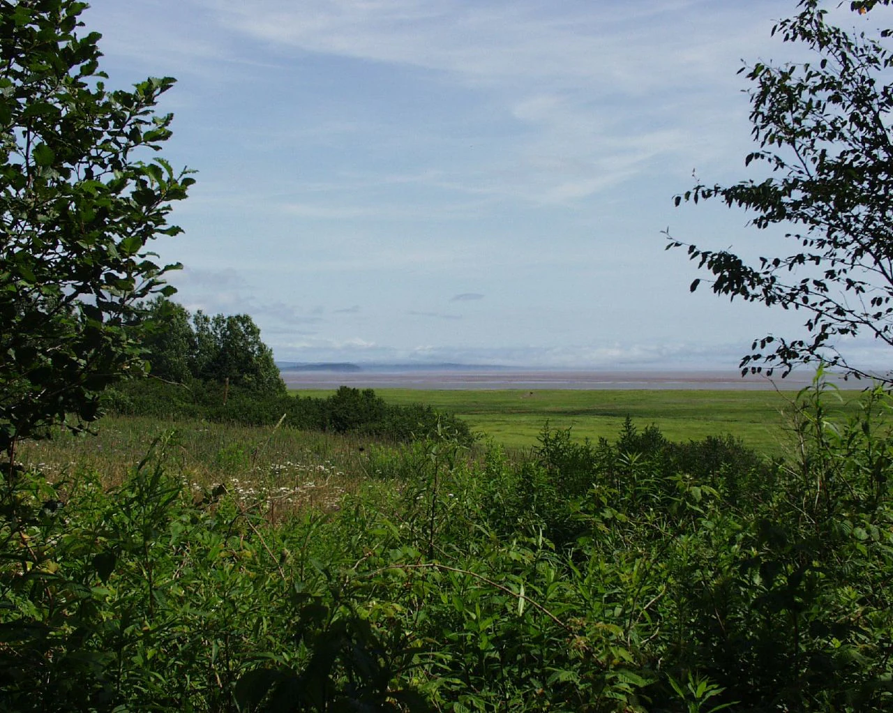
A framed view looking out over a wide, green coastal marshland toward distant, low-lying mudflats and the horizon under a cloudy sky.
A view overlooking the expansive coastal marshlands and mudflats at Mary's Point within the Shepody National Wildlife Area.

Shepody National Wildlife Area history and protected-area timeline

The Shepody National Wildlife Area was formally established on June 25, 1980, bringing together three existing ecologically important sites under a single federal protection framework administered by the Canadian Wildlife Service. The decision reflected growing awareness in the late twentieth century that the Bay of Fundy's extraordinary intertidal productivity and its role in the hemispheric shorebird migration required dedicated, long-term protection.

Within two years of its establishment, the Mary's Point unit earned international recognition when it was designated a Ramsar Wetland of International Importance on May 24, 1982. This formal acknowledgment highlighted the site's role as critical habitat for migratory waterbirds and as one of the most productive intertidal ecosystems on the Atlantic coast.

The area's conservation profile continued to expand through international cooperation. In 1987, Mary's Point became part of the Western Hemisphere Shorebird Reserve Network site for the Bay of Fundy, placing it within a continental framework for migratory bird protection. By 2007, Shepody had been included in the transition zone of the Fundy Biosphere Reserve, further embedding the wildlife area within a coordinated regional strategy for sustainable land use and biodiversity conservation in the Maritimes.

Shepody National Wildlife Area landscape and geographic character

The physical setting of Shepody National Wildlife Area is shaped almost entirely by water. Along the coast, Mary's Point forms a long, narrow strip of land stretching beside Chignectou Bay, fringed by an extensive sand and gravel beach on its northern side. Behind this narrow shoreline, the world's highest tides rise and fall across wide intertidal mudflats that are rich in organic content.

Inland, the Germantown Marsh occupies a low-lying stretch along the Chipoudy River near Riverside-Albert. Elevations across the reserve remain modest, ranging from sea level at the coast up to about 35 meters within the Germantown unit. The freshwater wetlands here contrast with the saline flats of Mary's Point, creating a varied hydrological landscape across the protected area's three distinct units.

Beneath this landscape lies a Carboniferous sandstone geology that records an ancient coastal environment. Fossilized remains of calamites, relatives of modern horsetails, and petrified tree trunks are preserved in the lower layers of bedrock, while deposits of albertite have added human historical significance to the area. The combination of tidal dynamics, riverine lowlands, and ancient sedimentary formations gives Shepody a layered physical character that is unusual even within the diverse Bay of Fundy coastline.

Shepody National Wildlife Area ecosystems, habitats, and plant life

Shepody National Wildlife Area protects a tightly interwoven set of coastal and freshwater ecosystems typical of the upper Bay of Fundy. Salt marshes and intertidal mudflats dominate the Mary's Point and New Horton units, while the Germantown unit adds extensive freshwater marshes and riparian woodlands along the Chipoudy River.

The mudflats of Mary's Point are among the most productive intertidal habitats in the Western Hemisphere. The nutrient-rich sediments support extraordinarily dense populations of small invertebrates, most notably the amphipod Corophium volutator, whose swarms in turn sustain enormous numbers of migratory shorebirds. Behind the tidal zone, the freshwater marshes filter river water, store floodwaters, and offer quieter habitat for breeding and resident waterfowl.

Together, the reserve's saline and freshwater habitats create a coastal complex that is unusually valuable for biodiversity considering the relatively small area involved. The juxtaposition of dynamic tidal flats, calm inland wetlands, and the brackish transition zones between them supports a wide range of feeding, roosting, and nesting strategies among birds and other wildlife.

Shepody National Wildlife Area wildlife and species highlights

The wildlife of Shepody is dominated, in scale and significance, by the autumn shorebird migration at Mary's Point. The intertidal flats here are estimated to host the world's densest population of Corophium volutator, an amphipod that forms the cornerstone of the local food web. Drawing on this resource, roughly three quarters of the entire semipalmated sandpiper population, often represented by around 300,000 birds, gathers at Mary's Point during southbound migration in late summer. Semipalmated sandpipers alone account for about 95 percent of all shorebirds observed in the Shepody Bay area.

A variety of other shorebirds join this migration, including least sandpipers, white-rumped sandpipers, semipalmated plovers, black-bellied plovers, sanderlings, ruddy turnstones, short-billed dowitchers, and greater yellowlegs. Raptors patrol the tidal margins in search of these concentrations, with merlins, peregrine falcons, and northern harriers among the most frequently observed predators.

The wider bird community of the reserve is rich. Ring-billed gulls, great black-backed gulls, American herring gulls, great Blue herons, common eiders, and Nelson's sparrows have all been documented across the salt marsh and freshwater units. The combination of tidal flats, marshes, and river habitats also supports waterfowl, songbirds, and a range of other coastal species throughout the year.

Shepody National Wildlife Area conservation status and protection priorities

Shepody National Wildlife Area plays an outsized role in migratory bird conservation in North America. The wildlife area's formal designations form a layered conservation framework: it was created as a National Wildlife Area in 1980, Mary's Point became a Ramsar Wetland of International Importance in 1982, the Bay of Fundy unit of the Western Hemisphere Shorebird Reserve Network was established in 1987, and the whole area was included in the Fundy Biosphere Reserve transition zone in 2007.

This stack of overlapping protections reflects the site's hemispheric and global importance. The intertidal flats of Mary's Point act as a critical refueling station for semipalmated sandpipers, a species whose entire eastern population passes through this single area in a matter of weeks. Protecting the mudflats, salt marsh fringe, and adjacent freshwater wetlands thus helps safeguard one of the most concentrated and predictable predator-prey interactions on the Atlantic coast.

The reserve also contributes to broader conservation objectives in the Bay of Fundy, including habitat preservation for waterfowl, shorebirds, and raptors, as well as the maintenance of productive intertidal and freshwater wetland ecosystems. As part of the Fundy Biosphere Reserve, it sits within a larger landscape-level effort to balance biodiversity protection with sustainable human activity across southeastern New Brunswick.

Shepody National Wildlife Area cultural meaning and human context

The lands around Shepody carry both geological and human history tied to the broader story of New Brunswick. The area's Carboniferous bedrock contains deposits of albertite, an asphalt-like mineral studied by Abraham Gesner, the province's first geologist, in his early nineteenth-century experiments that led to the development of kerosene as a commercial lighting fuel. The presence of this mineral in the same formations found within the reserve links the site to a foundational moment in the history of energy and geology in the Maritimes.

More broadly, the region around Albert County and Riverside-Albert has long been defined by its relationship with the Bay of Fundy tides, which have shaped settlement patterns, transportation, and livelihoods. Small coastal communities have historically depended on the fisheries, marsh hay, and tidal flats of the upper Bay. Today, the wildlife area is also culturally associated with birding and shorebird education, symbolized by the Mary's Point Shorebird Interpretation Centre, which connects visitors with one of Canada's most important migratory bird spectacles.

Top sights and standout views in Shepody National Wildlife Area

Shepody National Wildlife Area stands out as one of the most important shorebird sites in the Americas, where the world's densest known population of Corophium volutator feeds roughly three quarters of the entire semipalmated sandpiper population during autumn migration. The site holds an exceptional combination of global, continental, and regional ecological designations: Ramsar Wetland of International Importance, Western Hemisphere Shorebird Reserve Network site for the Bay of Fundy, National Wildlife Area, and part of the Fundy Biosphere Reserve.

The reserve's unusual geographical structure also stands out. Rather than forming a single contiguous block, Shepody brings together salt marsh, freshwater wetland, beach, and estuarine habitats in three distinct units, demonstrating how small coastal parcels can together sustain ecosystem-scale functions. The Carboniferous sandstone beneath the area adds a final layer of distinction, preserving fossils of ancient horsetails and trees and carrying a geological heritage connected to the early history of kerosene.

Best time to visit Shepody National Wildlife Area

The most dramatic natural event at Shepody, and the reason many visitors come to Mary's Point specifically, is the southbound shorebird migration in late summer. As the Bay of Fundy's tides draw down across the mudflats, tens of thousands of semipalmated sandpipers and other shorebirds concentrate to feed, creating a moving spectacle against the backdrop of the tidal flats. This window, generally spanning the warmest weeks of the year, offers the most intense wildlife experience the reserve can offer.

The broader coastal and freshwater landscapes of the reserve, however, hold seasonal interest across much of the year. Warmer months tend to bring the richest bird activity, while cooler seasons offer quieter landscapes and the chance to see raptors patrolling the tidal margins. Visitors interested in geology and tidal scenery will find Mary's Point's sand and gravel beach and the exposed Carboniferous cliffs a consistent point of interest across tidal cycles.
Monthly climate preview

Long-term temperature ranges and precipitation patterns across the protected coordinate

Réserve nationale de faune de Shepody Climate Normals and Monthly Weather Records

Measured temperature and precipitation normals for Réserve nationale de faune de Shepody illustrate the long-term annual rhythm recorded across the representative park coordinate. Examining the full twelve-month profile provides complete historical averages for month-by-month temperature ranges and daily precipitation values.
Annual mean5 °C
-7 °C17 °C
Jan-7°
Feb-6°
Mar-2°
Apr
May
Jun13°
Jul16°
Aug17°
Sep14°
Oct
Nov
Dec-3°
Warmest month
August

16.7 °C

Coolest month
January

-6.6 °C

Wettest month
November

3.7 mm/day

Driest month
August

2.5 mm/day

Park location guide

Geography guide, regional context, and park location map for Shepody National Wildlife Area

Shepody National Wildlife Area park geography, regions, and map view in Canada

Understand where Shepody National Wildlife Area sits in Canada through a broader geographic reading of the surrounding landscape, nearby location context, and its mapped position within the national park landscape.

How Shepody National Wildlife Area fits into Canada

Canada is a federal parliamentary constitutional monarchy spanning North America from the Atlantic to the Pacific and Arctic Oceans. With a population of over 41 million, it is officially bilingual in English and French at the federal level. The country gained independence from the United Kingdom through a gradual process culminating in 1982.

Wider geography shaping Shepody National Wildlife Area in Canada

Canada occupies the northern portion of North America, sharing its longest international border with the United States. The country extends from the Atlantic Ocean to the Pacific Ocean and northward into the Arctic Ocean, giving it the longest coastline of any nation.

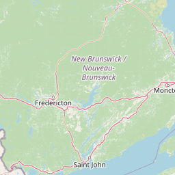
Map view of Shepody National Wildlife Area

Use this park location map to pinpoint Shepody National Wildlife Area in Canada, understand its exact geographic position, and read its mapped placement within the surrounding landscape more clearly.

Pigeon | © OpenStreetMap contributors

Location context for Shepody National Wildlife Area

New Brunswick

Visual reference for salt marshes, intertidal mudflats, and coastal habitats

Explore Réserve nationale de faune de Shepody Photos, Landscapes, and Scenery

Photographic collections reveal the complex terrain, coastal ecosystems, and protected environments of Réserve nationale de faune de Shepody. Visual records provide deep insight into the dynamic tidal flats and wetland mosaics that shape the landscape.

A framed view looking out over a wide, green coastal marshland toward distant, low-lying mudflats and the horizon under a cloudy sky.

A wide, flat marshy landscape under a blue sky with wispy clouds, with rolling hills visible on the distant horizon.

Park atlas

Compare adjacent coastal wetlands, regional sanctuaries, and connected wildlife habitats

Parks Near Réserve nationale de faune de Shepody and Related Protected Areas

Browsing nearby national parks and protected reserves reveals how regional coastal ecosystems connect across the broader Bay of Fundy landscape. Comparing adjacent wildlife habitats provides deeper context for the unique estuarine marshes and migratory bird staging grounds found here.
National parkNew Brunswick
About 14 km away#1 closest

Southwest

Fundy National Park: New Brunswick National Park Atlas and Geographic Exploration

Mapped protected landscape and regional park context.

Fundy National Park represents a vital protected area, offering rich geographic discovery within New Brunswick, Canada. This national park detail provides context for its mapped boundaries and landscape, supporting atlas-based exploration of its regional significance. Understand Fundy National Park's protected status and its contribution to the mapped natural terrain of eastern Canada.

Area
207 km²
Established
1948
IUCN
II
Visitors
303.6K annual
Watercolor painting of a tranquil marshy wetland with calm water, sparse dead trees, and distant hills under a light, hazy sky.
Wildlife reserveNova Scotia
About 41 km away#2 closest

East

Amherst Point Migratory Bird Sanctuary: Wetland Protected Landscape and Map Explorer

Nova Scotia Wildlife Reserve and Managed Marshland Habitat

Amherst Point Migratory Bird Sanctuary protects a significant freshwater marsh and ponded wetland network in Nova Scotia. This reserve is defined by its engineered diked impoundments and role as a crucial stopover for migratory birds in the Atlantic flyway, offering a clear window into managed wetland conservation and coastal marsh terrain.

Area
4.33 km²
Established
1947
IUCN
IV
A minimalist watercolor illustration showing soft green hills in the distance, a calm body of water, and stylized reddish vegetation in the foreground.
Wildlife reserveNova Scotia
About 54 km away#3 closest

South

Île Haute Wildlife Reserve: Mapped Volcanic Geography and Coastal Protected Terrain

Bay of Fundy protected area, Nova Scotia

Rising abruptly from the Bay of Fundy, Île Haute features a steep, isolated plateau encircled by 100-meter basalt cliffs. This wildlife reserve showcases Jurassic volcanic geology and provides essential habitat for migratory seabirds and marine mammals. Gain insights into the island's unique coastal geography and its role as a protected natural sanctuary in Atlantic Canada.

Area
0.8 km²
Established
2025
Relief
Upland
Scope
Mixed
Wildlife reserveNova Scotia
About 70 km away#4 closest

South

Kentville Migratory Bird Sanctuary: A Protected Wetland Reserve in the Cornwallis River Valley

Mapped riparian ecosystems and migratory bird habitats in Nova Scotia.

Discover the unique geography of the Kentville Migratory Bird Sanctuary, a compact wildlife reserve in Nova Scotia. This protected area features a blend of river channels, open fields, and forest mosaic that serves as a seasonal sanctuary for waterfowl. Learn about the riparian terrain that defines this critical node in the broader Atlantic flyway network.

Area
5.06 km²
Established
1939
Relief
Lowland
Scope
Terrestrial
A soft watercolor painting showing a coastal landscape with green low-lying vegetation, a stretch of water, and rolling hills in the distance under a pale sky.
Wildlife reserveNova Scotia
About 74 km away#5 closest

Southeast

Boot Island National Wildlife Area: Mapping Coastal Conservation in Nova Scotia

Protecting intertidal mudflats and migratory bird habitats

Located in the Southern Bight of the Minas Basin, Boot Island National Wildlife Area serves as a key protected refuge within the Bay of Fundy. This reserve safeguards essential coastal and marshland habitats that support migratory bird populations, offering a focused look at how specific island geography functions within a larger, dynamic estuarine wetland system.

Area
1.07 km²
Established
1979
IUCN
Ia
Relief
Lowland
A horizontal watercolor painting showing a pale green and soft pink landscape with distant hills, a calm body of water, and a tree-lined shore.
Wildlife reserveNew Brunswick
About 88 km away#6 closest

Northeast

Réserve nationale de faune du Cap-Jourimain: Protected Coastal Wetlands and Wildlife Maps

Essential geographic context for a strategic New Brunswick wildlife reserve

Examine the mapped boundaries and complex ecosystem transitions of Réserve nationale de faune du Cap-Jourimain. This federally protected area in New Brunswick offers a distinct look at coastal marshlands, tidal flats, and island topography situated at the narrowest point of the Northumberland Strait.

Area
6.617 km²
Established
1980
IUCN
IV
Relief
Lowland
National parkNew Brunswick
About 110 km away#7 closest

North

Kouchibouguac National Park: New Brunswick Protected Landscape Atlas

Mapped protected area boundaries and regional geography.

Kouchibouguac National Park is a designated national park offering a rich canvas for geographic discovery. This entry focuses on understanding its protected landscape, detailing its specific mapped boundaries within New Brunswick. It serves as a vital component for atlas exploration, providing the context needed to grasp the park's natural terrain and its significance within the regional geography.

Area
238 km²
Established
1969
IUCN
II
Visitors
243.5K annual
Wildlife reserveNew Brunswick
About 124 km away#8 closest

West

Portobello Creek National Wildlife Area: Protected Wetland Geography and Regional Atlas

Saint John River floodplain reserve in New Brunswick

Portobello Creek National Wildlife Area protects an expansive wetland complex characterized by riverine marshes, shrub thickets, and low-lying floodplain forests. As a key site within the Saint John River system, the reserve offers unique insight into the geomorphic and ecological character of Atlantic Canadian wetlands.

Area
21.54 km²
Established
1995
IUCN
Ia
Relief
Lowland

Common questions about visiting, size, designation, and location context for Shepody National Wildlife Area

Shepody National Wildlife Area FAQs for park facts, access, geography, and protected area context

Find quick answers about Shepody National Wildlife Area, including protected-area facts, park geography, trail and visitor context, and how the park fits into its surrounding country and regional landscape.
MoriAtlas Explorer

Continue Your Protected Areas Search Across the Global Atlas

Deepen your exploration by continuing the structured search for national parks and protected areas worldwide. Utilize the comprehensive filtering capabilities to compare different conservation landscapes and refine your understanding of global park geography. Discover more about the distribution and characteristics of protected natural areas.

Global natural geography