

Mori Atlas logo
Natural monumentSite paléontologique de La Lieude

Examining Permian-era fossil trackways and ancient reptile movement across French sedimentary terrain

Site paléontologique de La Lieude: A Protected Geological Monument in the Hérault Landscape

The Site paléontologique de La Lieude represents a critical geological window into deep time, preserving a unique bedding plane from the Permian period within the Hérault department of southern France. Featuring nearly a thousand fossilized footprints and eighteen distinct trackways of pre-mammalian reptiles, the site serves as a vital reference for paleontological research in the Lodève basin. This protected geotope offers a rare look at prehistoric terrestrial biodiversity along the Mediterranean fringes of the Massif Central.

paleontological sitetrace fossilsPermian fossilspre-mammalian reptilesgeotopefossil trackways

Site paléontologique de La Lieude

Natural monument

Park overview

Structured park overview, official facts, and landscape profile for Site paléontologique de La Lieude

Site paléontologique de La Lieude park facts, protected area profile, and essential visitor context

Review the core facts for Site paléontologique de La Lieude, including designation, size, terrain, visitor scale, habitats, and operating context in one park-focused overview.

About Site paléontologique de La Lieude

The Site paléontologique de La Lieude is a paleontological locality of international relevance situated in the southern French department of Hérault. It consists of a single Permian-age bedding surface, known as the dalle de La Lieude, that preserves an extraordinary record of animal tracks made around 250 million years ago, just before the end of the Paleozoic era.

The track-bearing surface documents the passage of small pre-mammalian reptiles, a group of synapsids often referred to as therapsids or their close relatives, that inhabited the landscapes of what is now southern France during the late Permian. Twenty separate trackways cross the surface, and within them nearly a thousand individual footprints can be counted, representing four distinct ichnospecies. The quality and density of preservation have allowed paleontologists to study not only which animals moved across the site but also aspects of their gait, stride length, and likely behavior, giving the locality a particular importance within European vertebrate ichnology.

La Lieude sits in the commune of Mérifons, in a rural landscape shaped by the northern edge of the Hérault countryside and the nearby influence of the Massif Central. The site's wider geological context is the Lodève basin, a Permian sedimentary basin long studied for its continental red-bed deposits. Within this broader geological setting, La Lieude stands out as the most cited example of fossil vertebrate trackways, complementing body-fossil sites with a vivid record of living animals.

Although the site was once classified as a voluntary nature reserve and later as a regional nature reserve, it is no longer under that regime. Since 2019, the trackway surface has been protected under a prefectural order for the protection of geotopes, recognizing both its scientific and its heritage value. Today, La Lieude functions primarily as a scientific and educational reference locality, drawing interest from paleontologists, students, and visitors curious about the deep history of the region.

Quick facts and research context for Site paléontologique de La Lieude

The La Lieude paleontological site lies on the commune of Mérifons in the Hérault department of southern France, within the broader Occitanie region and near the foothills of the Massif Central. It preserves a single fossil-bearing bedding plane, commonly called the dalle de La Lieude, dating from the late Permian period, around 250 million years ago.

The surface exposes 18 vertebrate trackways and 951 individual footprints attributed to four species of pre-mammalian reptiles, making it one of the most important late Permian ichnological sites in France. The locality received national attention in the late twentieth century and is now formally protected as a geotope by prefectural order.

Protection and recognition

Review documented conservation management scope and official registry records

Site paléontologique de La Lieude Protection Status and Mapped Data Records

Examine the verified protection status and administrative registry records associated with Site paléontologique de La Lieude. Available governance tracking details and international database identifiers provide structured context for this protected natural area.

Protection details

WDPA ID
555702199
Park context

Deeper park guide and search-rich context for Site paléontologique de La Lieude

Site paléontologique de La Lieude history, landscape, wildlife, and travel context

Explore Site paléontologique de La Lieude through its history, landscape character, ecosystems, wildlife, conservation priorities, cultural context, and seasonal travel timing in a structured park guide built for atlas discovery and search intent.

Why Site paléontologique de La Lieude stands out

La Lieude is best known internationally for its exceptionally rich assemblage of late Permian vertebrate trace fossils. The single exposed bedding plane captures the tracks of small pre-mammalian reptiles moving across a muddy surface close to the Permian period, providing one of the clearest records of early synapsid locomotion from this part of Europe. The site's scientific value comes from the combination of diversity and density of tracks: four distinct ichnospecies are represented by hundreds of footprints arranged in clearly defined pathways. This makes La Lieude a reference locality for paleontologists studying the behavior, locomotion, and biodiversity of terrestrial vertebrate faunas at the close of the Paleozoic era.
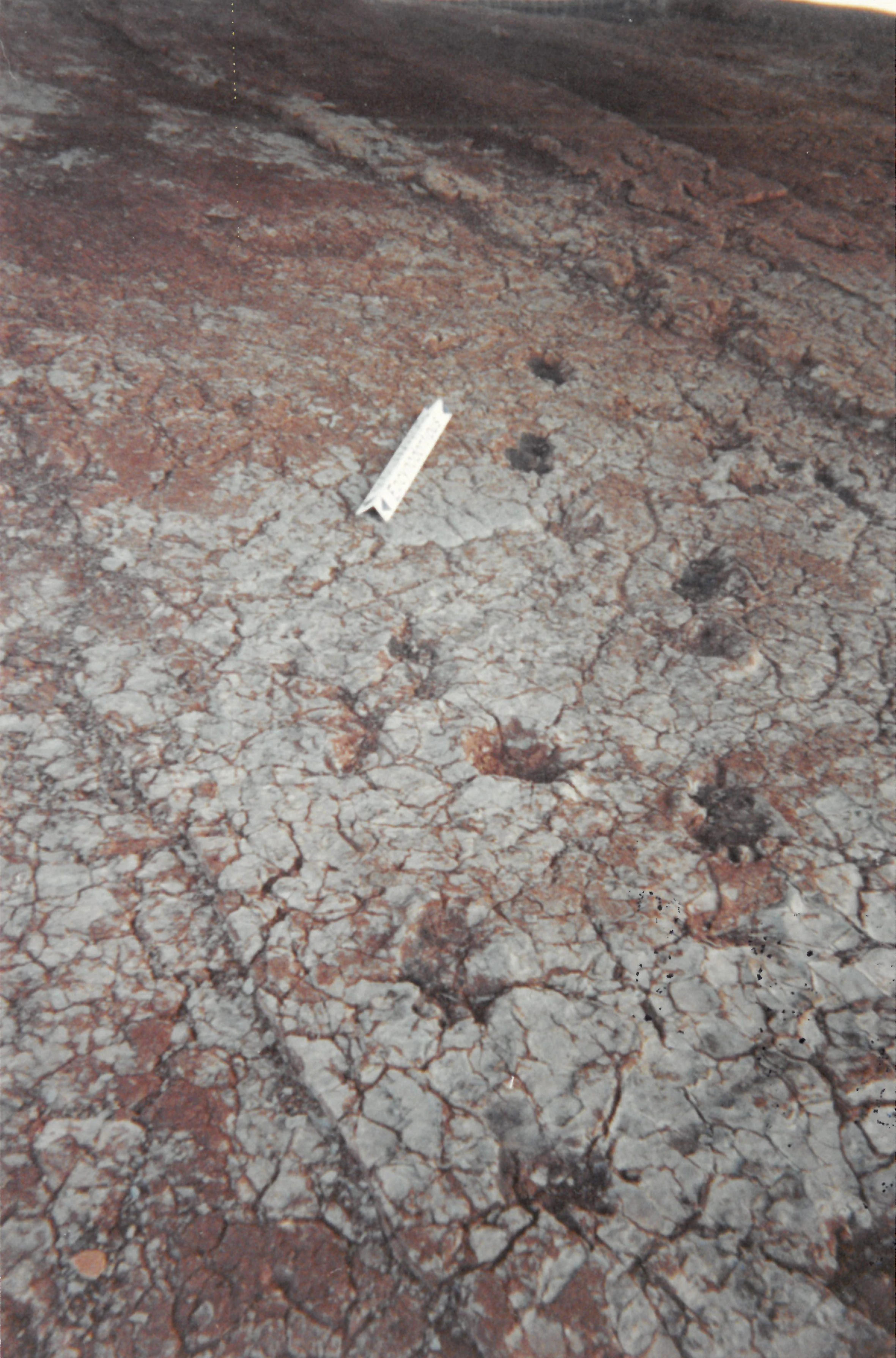
La Lieude Paleontological Site Slab
Paleontological slab at the La Lieude site, scanned film photograph.

Site paléontologique de La Lieude history and protected-area timeline

The La Lieude trackway surface was discovered in 1950 by a local winegrower working in the vineyards around Mérifons. What initially appeared to be unusual markings on a flat rock surface soon attracted the attention of geologists and paleontologists, who recognized the markings as genuine Permian-age fossil footprints.

The scientific significance of the find led to formal protection: in 1986, the site was classified as a Réserve Naturelle Volontaire, or voluntary nature reserve, for a renewable period of six years. The French law of 27 February 2002, known as the 'démocratie de proximité' law, reorganized this status by converting the voluntary nature reserves into regional nature reserves (Réserves Naturelles Régionales). La Lieude fell under this new framework, but an implementing decree of 18 May 2005 clarified that the conversion covered only the remaining period of the initial voluntary agreement. As a result, the regional nature reserve classification for La Lieude ended around the early 2000s, and by September 2010 the site was no longer formally a regional nature reserve.

A new phase of protection began on 13 June 2019, when the trackway was placed under a prefectural order for the protection of geotopes (arrêté préfectoral de protection de géotope). This order safeguards the paleontological surface itself, ensuring that the international scientific heritage represented by the La Lieude footprints continues to be protected even though the broader reserve status has lapsed.

Site paléontologique de La Lieude landscape and geographic character

La Lieude lies in the rolling countryside of the northern Hérault, on the edge of the Massif Central in southern France. The local landscape is shaped by Mediterranean-influenced hills, vineyards, scrubland, and occasional exposed rock surfaces that hint at the underlying geological structure of the Lodève basin.

Site paléontologique de La Lieude conservation status and protection priorities

La Lieude's conservation significance lies in the protection of a single, internationally important paleontological surface. Although the site is not a biological reserve and does not aim to protect living ecosystems, its scientific value depends entirely on preserving the integrity of the Permian-age bedding plane that exposes hundreds of vertebrate footprints.

For decades, the site was protected within the French voluntary nature reserve network, a status intended to safeguard natural heritage sites of regional interest. When the reserve framework ended, a new, more targeted protection was put in place in 2019 through a prefectural order for the protection of geotopes. This type of protection focuses specifically on geological heritage, ensuring that the trackway surface cannot be damaged, removed, or altered in ways that would compromise its scientific and educational value.

Site paléontologique de La Lieude cultural meaning and human context

Beyond its scientific role, La Lieude reflects a strong regional tradition of amateur and professional interest in local geology and paleontology within the Hérault and the wider Languedoc. The site was originally discovered not by a scientist but by a local winegrower, underscoring the importance of rural communities in identifying natural heritage in this part of France. The Lodève basin has long attracted geologists because of its well-exposed Permian red beds, and La Lieude has become part of that broader local heritage, contributing to the identity of the commune of Mérifons and to the cultural landscape of the northern Hérault.

Top sights and standout views in Site paléontologique de La Lieude

The standout feature of La Lieude is the Permian trackway surface itself, where 18 vertebrate pathways and 951 footprints of pre-mammalian reptiles are preserved on a single bedding plane. Four ichnospecies contribute to this assemblage, giving the site an unusually rich record of late Permian terrestrial life. Its location on the edge of the Massif Central, within the Hérault department, adds a strong regional-geology dimension to its international paleontological importance, while its long protection history, culminating in the 2019 geotope order, confirms its lasting value as a piece of French natural heritage.

Best time to visit Site paléontologique de La Lieude

La Lieude is a geological heritage site rather than a conventional visitor attraction, and conditions for visiting depend primarily on the visibility and accessibility of the trackway surface. The mild seasons of spring and autumn generally offer the most comfortable conditions for outdoor geological visits in the Hérault, when the landscape is at its most pleasant and the exposed rock surface can be examined under good light. Summer heat and winter weather can make the site less convenient to explore, but the bedrock itself is a stable, durable feature that remains scientifically and visually interesting year-round.
Monthly climate preview

Long-term representative point measurements tracking monthly temperature and precipitation patterns across Hérault

Site paléontologique de La Lieude Climate Normals and Annual Temperature Rhythm

Historical climate data from 1991 to 2020 documents a measured progression of monthly temperature averages and precipitation levels across the representative coordinate at Site paléontologique de La Lieude. Deeper statistical analysis of the full twelve-month profile provides complete monthly normals for examining long-term environmental trends.
Annual mean13 °C
5 °C23 °C
Jan
Feb
Mar
Apr11°
May15°
Jun20°
Jul23°
Aug23°
Sep18°
Oct14°
Nov
Dec
Warmest month
July

22.7 °C

Coolest month
January

4.9 °C

Wettest month
October

2.6 mm/day

Driest month
July

0.8 mm/day

Park location guide

Geography guide, regional context, and park location map for Site paléontologique de La Lieude

Site paléontologique de La Lieude park geography, regions, and map view in France

Understand where Site paléontologique de La Lieude sits in France through a broader geographic reading of the surrounding landscape, nearby location context, and its mapped position within the national park landscape.

How Site paléontologique de La Lieude fits into France

France is a unitary semi-presidential republic and one of the world's largest economies. It borders Belgium, Luxembourg, Germany, Switzerland, Italy, Monaco, Andorra, and Spain, with a maritime border to the United Kingdom. The country is known for its cultural influence, art, cuisine, and political history spanning centuries.

Wider geography shaping Site paléontologique de La Lieude in France

France is located in Western Europe. Metropolitan France extends from the Rhine to the Atlantic Ocean and from the Mediterranean Sea to the English Channel and North Sea. The country borders Belgium, Luxembourg, Germany, Switzerland, Italy, Monaco, Andorra, Spain, and has a maritime border with the United Kingdom.

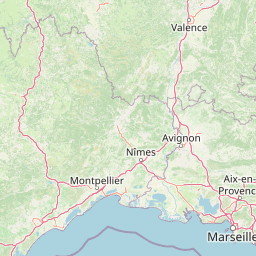
Map view of Site paléontologique de La Lieude

Use this park location map to pinpoint Site paléontologique de La Lieude in France, understand its exact geographic position, and read its mapped placement within the surrounding landscape more clearly.

Pigeon | © OpenStreetMap contributors

Location context for Site paléontologique de La Lieude

Hérault

Visual reference guide to the geological terrain, fossil surfaces, and southern French regional scenery.

Site paléontologique de La Lieude Photos and Protected Landscape Scenery

Browse detailed photographs of Site paléontologique de La Lieude to examine the Mediterranean hills, exposed rock surfaces, and protected terrain of the Lodève basin. Visual documentation reveals the physical environment surrounding an internationally significant paleontological heritage site in southern France.

La Lieude Paleontological Site Slab

Park atlas

Discover related protected landscapes and regional geological heritage across the Massif Central

Parks near Site paléontologique de La Lieude: Exploring Southern France Protected Areas

Compare protected areas surrounding Site paléontologique de La Lieude to examine regional geography and connected natural heritage. Extending the geographic review allows visitors to trace similar geological formations across southern France.
Watercolor illustration of green fields, a river, and mountains under a soft pink and yellow sky
National parkOccitanie
About 40 km away#1 closest

North

Cévennes National Park: Explore its Mapped Terrain and Protected Landscape in Occitanie

Discover the unique geographic context and park boundaries.

Cévennes National Park, situated in Occitanie, France, offers a rich exploration of mid-mountain Mediterranean geography. As a protected landscape, its mapped terrain features dramatic limestone plateaus, deep river gorges, and distinct granite massifs. This entry provides essential geographic context for Cévennes National Park, highlighting its unique natural features and its significance as a protected area within the broader regional atlas.

Area
937 km²
Established
1970
IUCN
V
Visitors
800K annual
Protected areaHérault
About 45 km away#2 closest

Southeast

Salins de Frontignan: An Atlas of Protected Coastal Wetlands in the Hérault Region

Explore saline landscapes and marshland geography on the Gulf of Lion.

Located in the Hérault department, Salins de Frontignan offers a fascinating study in coastal geography and ecological reclamation. This protected area features abandoned salt marshes that have evolved into a vital network of evaporation basins, salt steppes, and lagoon margins. The site serves as a crucial habitat for specialized halophytic plants, positioned uniquely between the Mediterranean shoreline and the limestone foothills of the Gardiole range.

Area
2.795 km²
Established
1980
IUCN
IV
Relief
Lowland
Nature reserveOccitanie
About 67 km away#3 closest

South

Réserve naturelle régionale de Sainte-Lucie: Protected Coastal Geography in Occitanie

Coastal lagoons, island habitats, and Mediterranean marshlands.

This protected area profile explores the physical geography of Réserve naturelle régionale de Sainte-Lucie. Understand the interplay between the central island landform, brackish lagoon networks, and the Mediterranean beach ecosystems that define this unique French conservation landscape.

Area
8.25 km²
Established
2009
IUCN
IV
Relief
Lowland
Nature reserveOccitanie
About 78 km away#4 closest

East

Réserve naturelle régionale de Mahistre et Musette: Regional Nature Reserve and Wetland Atlas

Petite Camargue geography and protected marshland mosaic in Occitanie

Located in the Gard department of southern France, the Réserve naturelle régionale de Mahistre et Musette represents a successful case of wetland restoration. This protected area features a distinct landscape of reedbeds, saline flats, and ponds, providing critical habitat for numerous wetland species. Access detailed geographic context on how these restored marshes link to the broader Petit Camargue environmental network.

Area
2.616 km²
Established
1999
IUCN
IV
Regional parkProvence-Alpes-Côte d'Azur
About 80 km away#5 closest

East

Parc naturel régional de Camargue: Mapping the Rhône Delta Protected Wetland Landscape

Regional park geography and wetland conservation zones

Parc naturel régional de Camargue is a sprawling protected landscape at the confluence of the Rhône and the Mediterranean. This regional park contains significant saline lagoons, coastal dunes, and fertile marshes that serve as a crucial site for waterbird migration. Understand the interplay between traditional salt-making, pastoral ranching, and the strictly protected nature reserves that shape this delta territory.

Area
856.9 km²
Established
1970
IUCN
V
Relief
Lowland
Nature reserveGard
About 87 km away#6 closest

East

Réserve naturelle régionale du Scamandre: Mapped Boundaries and Wetland Geography in Gard

Protected marshlands and salt steppe in southern France.

Deep dive into the ecological layout of Réserve naturelle régionale du Scamandre. Situated in the Gard department, this protected site preserves a mosaic of prairie, sansouïre, and marshland, creating a high-density wetland corridor essential for regional biodiversity and landscape analysis.

Area
1.467 km²
Established
2006
IUCN
IV
Relief
Lowland
Nature reserveOccitanie
About 92 km away#7 closest

West

Réserve naturelle régionale de Cambounet-sur-le-Sor: Protected Wetland Geography

Alluvial floodplain habitat in the Tarn, Occitanie

Situated in the Tarn department of Occitanie, this nature reserve guards a dense wetland habitat shaped by the confluence of the Sor and Agout rivers. The area stands as an ecological centerpiece, providing sheltered riparian woodland and marshy terrain for more than one hundred and seventy recorded bird species, making it a distinct study in French riverine conservation.

Area
0.309 km²
Established
1990
IUCN
IV
Relief
Lowland
Nature reserveOccitanie
About 98 km away#8 closest

East

Réserve naturelle régionale des gorges du Gardon: Geography and Protected Area Overview

Mediterranean river valley and raptor conservation corridor

Examine the distinct topography of the Réserve naturelle régionale des gorges du Gardon. The protected area features steep limestone cliffs and a river corridor that sustains dense Mediterranean oak forests. This site remains a critical node for raptor conservation, specifically supporting nesting Egyptian vultures and Bonelli eagles within its structured valley geography.

Area
4.913 km²
Established
2007
IUCN
IV

Common questions about visiting, size, designation, and location context for Site paléontologique de La Lieude

Site paléontologique de La Lieude FAQs for park facts, access, geography, and protected area context

Find quick answers about Site paléontologique de La Lieude, including protected-area facts, park geography, trail and visitor context, and how the park fits into its surrounding country and regional landscape.
MoriAtlas Explorer

Continue Your Protected Areas Search Across the Global Atlas

Deepen your exploration by continuing the structured search for national parks and protected areas worldwide. Utilize the comprehensive filtering capabilities to compare different conservation landscapes and refine your understanding of global park geography. Discover more about the distribution and characteristics of protected natural areas.

Global natural geography