
Mori Atlas logo
Natural monumentSklenářovické údolí

Examining the ecological terrain, meadow mosaics, and Zlatý potok valley boundaries

Sklenářovické údolí: A Mapped Protected Landscape in the Eastern Krkonoše Foothills

(Přírodní památka Sklenářovické údolí)

Sklenářovické údolí represents a critical protected landscape within the Královéhradecký kraj region of the Czech Republic. This natural monument preserves a distinctively incised valley carved by the Zlatý potok, characterized by a rare mosaic of submontane meadows, hygrophilous wetlands, and forest edges. The area serves as a primary reference for tracking restored grassland biodiversity and the spatial relationship between open montane habitats and dense woodland slopes.

natural monumentmeadowswetlandssubmontane grasslandsKrkonoše foothillsorchid habitat
A flat, stylized vector illustration of a mountain valley, featuring pine trees in the foreground, a river, and a waterfall cascading down a mountain face under a soft, clouded sky.

Sklenářovické údolí

Natural monument

Park overview

Structured park overview, official facts, and landscape profile for Sklenářovické údolí

Sklenářovické údolí park facts, protected area profile, and essential visitor context

Review the core facts for Sklenářovické údolí, including designation, size, terrain, visitor scale, habitats, and operating context in one park-focused overview.

About Sklenářovické údolí

Sklenářovické údolí occupies a deeply cut valley in the eastern foothills of the Krkonoše mountains, where the landscape transitions from the colder, forested core of the range into the warmer submontane countryside of northeastern Bohemia. The valley follows the course of Zlatý potok and is flanked by Sklenářovický vrch to the east, reaching 921 meters, and by the forested ridge of Bartův les to the west. Within this narrow but biologically rich corridor, the protected natural monument preserves a network of meadows, springs, wet flushes, and forest edges that together form an unusually complete picture of how this landscape once looked under traditional rural management.

The ecological significance of the valley lies in the persistence of an old cultural landscape, in which seminatural grasslands have retained their species composition despite dramatic changes in land use elsewhere in the region. After the original German-speaking inhabitants of Sklenářovice were expelled following the Second World War and the village was abandoned, the surrounding meadows began to lose their open character. Since 1999, the Krkonoše National Park administration has been carrying out a phased restoration of these grasslands, re-establishing the conditions under which a very diverse community of meadow plants could survive. The current mosaic includes drier slopes, mesic meadows, peat-influenced wet flushes, and reed-fringed pools, each supporting slightly different plant communities.

What sets Sklenářovické údolí apart from many other small protected sites is the simultaneous presence of high botanical and high zoological value. The flora includes several species of wild orchids that are rare or declining across Central Europe, such as Dactylorhiza sambucina, Dactylorhiza majalis, Gymnadenia conopsea, Orchis mascula, and Platanthera bifolia, alongside moisture-loving species like Parnassia palustris. The same open and partly wooded mosaic provides habitat for an unusual bird community that includes both tree-nesting raptors and ground-nesting game birds, as well as amphibians and reptiles typical of cool, well-vegetated upland valleys. Together, these qualities place the valley firmly within the broader conservation strategy of the Krkonoše region, even though it lies outside the strict national park boundary itself.

Quick facts and research context for Sklenářovické údolí

Sklenářovické údolí is a Czech natural monument (přírodní památka) declared on 1 March 2009 by the Krkonoše National Park administration. The protected area covers roughly 180 hectares between approximately 575 and 935 meters above sea level. It lies in the foothills of the Krkonoše mountains, in the Trutnov district near Mladé Buky.

The site is classified as an IUCN Category III protected area and represents one of the most botanically diverse meadow and wetland complexes in the eastern Krkonoše foreland. Its clear connection to the Krkonoše National Park administration makes it functionally part of the broader conservation landscape of the Giant Mountains.

Protection and recognition

Documented terrestrial conservation scope and official designation records

Sklenářovické údolí Protection Status and International Recognition Data

Sklenářovické údolí maintains a documented terrestrial protection scope without supplementary international recognition sources or transboundary status. Structured conservation records compile baseline designation frameworks to support detailed environmental research and regional geographic analysis.

Protection details

Protection scope
Terrestrial
Transboundary protection
No
Park context

Deeper park guide and search-rich context for Sklenářovické údolí

Sklenářovické údolí history, landscape, wildlife, and travel context

Explore Sklenářovické údolí through its history, landscape character, ecosystems, wildlife, conservation priorities, cultural context, and seasonal travel timing in a structured park guide built for atlas discovery and search intent.

Why Sklenářovické údolí stands out

Sklenářovické údolí is best known for its mosaic of submontane and montane meadows interspersed with wetlands, one of the most floristically rich grassland habitats in the Krkonoše foothills. The valley supports a remarkable concentration of protected orchids, including several Dactylorhiza and Orchis species, alongside hygrophilous plants such as Parnassia palustris. The area is equally recognized for its rare birdlife, including the critically endangered red kite, the lesser spotted eagle, the western capercaillie, and the black stork. This combination of botanically rich open habitats and significant raptor presence makes the valley stand out within the regional network of smaller protected sites in the Czech Republic.
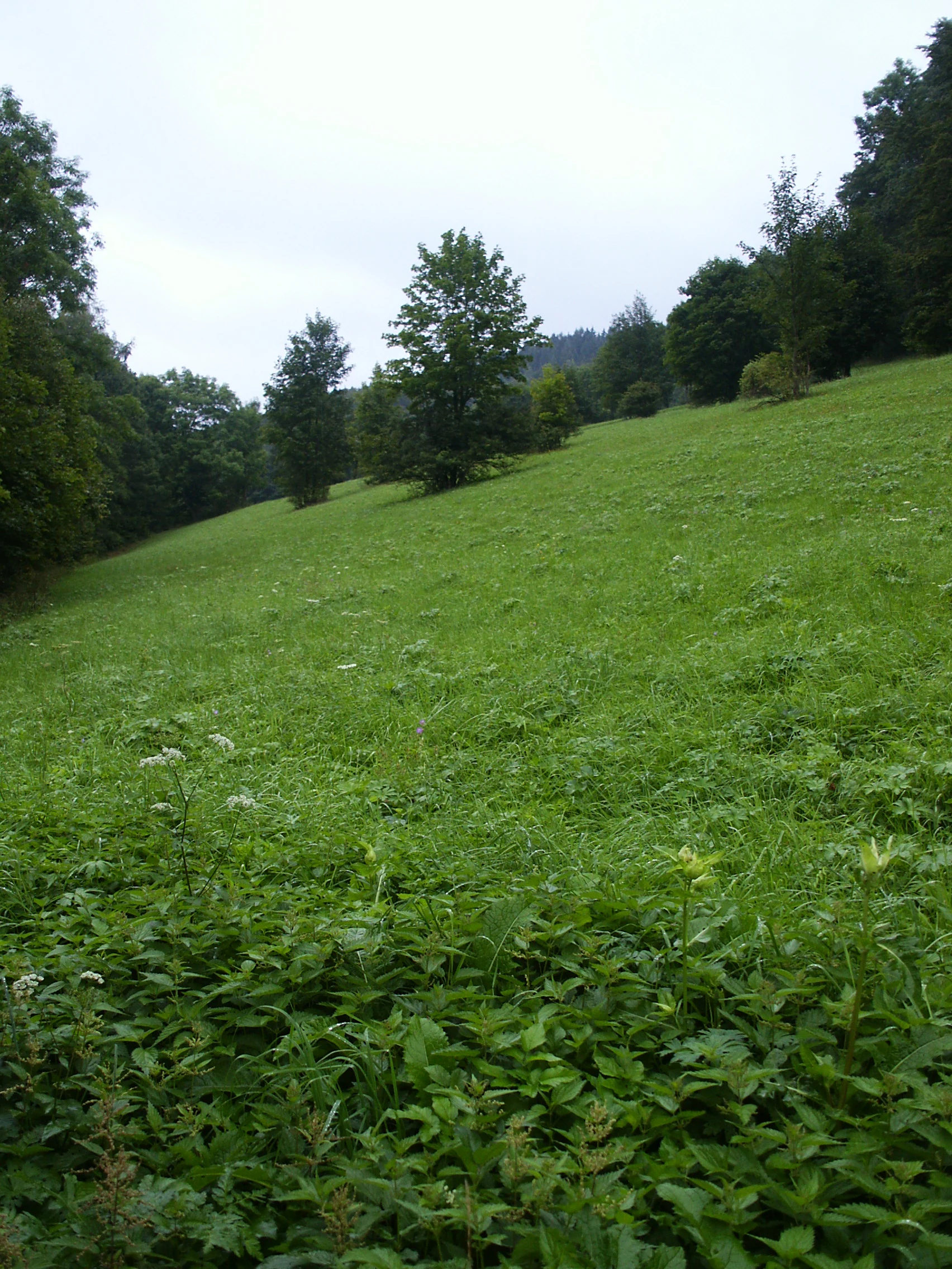
A wide, grassy meadow sloping upward under a cloudy sky, framed by forest edges on both sides.
A view of the submontane meadows in Sklenářovické údolí.

Sklenářovické údolí history and protected-area timeline

The landscape of Sklenářovické údolí was shaped over centuries by the agricultural activity of the village of Sklenářovice, whose meadows and pastures covered the floor and lower slopes of the valley. The village itself was one of many small settlements in the Sudetenland region whose existence ended abruptly after the Second World War: the German-speaking inhabitants were expelled and the village was subsequently abandoned. With no one left to hay the meadows or manage the surrounding land, the open grasslands began a slow process of ecological decline as shrubs and trees encroached from the edges.

The inflection point in the valley's modern history came in 1999, when systematic restoration of the meadows began under the supervision of what is now the Krkonoše National Park administration. The goal was to recover the open, species-rich grassland mosaic that had historically supported the valley's botanical richness. The restoration progressed gradually and was followed, in 2009, by formal designation of the area as a protected natural monument, or přírodní památka, on 1 March 2009. The legal protection solidified the long-term conservation of the restored meadows and the surrounding forest-edge habitats, and placed the site within the institutional framework that also manages the adjacent Krkonoše National Park.

Sklenářovické údolí landscape and geographic character

Sklenářovické údolí is a narrow, strongly incised valley carved by Zlatý potok into the eastern foothills of the Krkonoše. The valley's defining topography is the contrast between Sklenářovický vrch, rising to 921 meters on the eastern side, and the extensive forested ridge of Bartův les on the western side, which reaches 732 meters. This juxtaposition of an open, meadow-covered hillside across from a heavily wooded ridge gives the valley its characteristic cross-section of contrasting habitats within a very short distance.

The valley floor itself is gentle and wide enough to have supported agriculture for centuries, with a network of springs, wet flushes, and small marshy depressions running along the stream. These features, along with the steep side slopes and the forested upper edge of Bartův les, create a layered landscape in which wet, dry, open, and shaded conditions are all present at once. The overall elevation range of the protected area spans roughly from 575 meters at the lowest part of the valley to about 935 meters on the higher slopes, which is unusually broad for a site of this size and is one of the factors behind the diversity of the vegetation.

Sklenářovické údolí ecosystems, habitats, and plant life

Ecologically, Sklenářovické údolí preserves one of the best examples in the eastern Krkonoše region of a transition between submontane and montane vegetation belts. The valley sits high enough to support montane meadow communities, while its lower, wetter sections retain relict stands of more hygrophilous plant communities that have largely disappeared from the wider Czech countryside. This combination of altitudinal range and habitat diversity is the foundation of the site's botanical importance.

The vegetation pattern is best described as a mosaic rather than a single dominant community. Mesic meadows occupy the central slopes, with drier, more species-rich swards on the sunnier eastern exposures above Sklenářovický vrch. Wet meadows, flushes, and small sedge-dominated areas lie alongside the stream, with patches of reed and marsh vegetation in the most consistently saturated places. Forest edges, scrub, and isolated trees form a soft boundary with the larger woodland of Bartův les and with the upper slopes of Sklenářovický vrch, creating the fine-grained transitions that many grassland-dependent species need for foraging, nesting, and shelter.

Sklenářovické údolí wildlife and species highlights

The wildlife of Sklenářovické údolí is inseparably linked to the openness and diversity of its grassland mosaic. Birds are the most visible and ecologically important group, and the valley is notable for supporting several species that have become rare or threatened across the wider Central European landscape. The critically endangered red kite is one of the area's signature species, alongside the lesser spotted eagle, the black stork, the Eurasian sparrowhawk, the Eurasian hobby, the common quail, and, in the surrounding forest, the western capercaillie.

Beyond birds, the valley's mixture of wet meadows and forest provides habitat for a wide range of other animals. The European adder is present in suitable grassy and rocky places, and the alpine newt inhabits the cooler wet habitats along the stream and its associated pools. The combination of prey-rich meadows and mature forest nearby also supports small mammal populations that sustain the raptors nesting in the surrounding woodland. As a whole, the fauna reflects what is increasingly rare in the modern Czech landscape: a working mosaic of grassland and forest that supports the full ecological cycle of species depending on open ground, water margins, and nearby woodland cover.

Sklenářovické údolí conservation status and protection priorities

Sklenářovické údolí is protected primarily for its unusually well-preserved mosaic of submontane and montane meadows, wetlands, and forest-edge habitats, and for the rich flora and fauna that depend on this combination. The site is formally classified as a přírodní památka, a Czech natural monument, and falls within IUCN Category III. Its administration by the Krkonoše National Park administration ties it directly into the management framework of the broader Krkonoše conservation landscape, even though the monument itself lies outside the strict boundaries of the national park.

The conservation story of the valley is closely bound up with active landscape management. The restoration of the meadows, begun in 1999 and formalized by legal protection in 2009, is a deliberate attempt to reverse the ecological consequences of the mid-twentieth-century depopulation of the Sudetenland. Without regular mowing, grazing, and removal of encroaching woody vegetation, the very plant communities that justify the site's protection would gradually disappear. The protected-monument designation ensures that this management can continue over the long term, and the result is a site in which exceptional biodiversity is maintained not by accident but as the explicit outcome of ongoing stewardship.

Sklenářovické údolí cultural meaning and human context

The cultural dimension of Sklenářovické údolí is inseparable from the history of the village of Sklenářovice, which once occupied the valley floor. Like many settlements in the borderland of the former Sudetenland, the village's history was abruptly altered by the post-war expulsion of the German-speaking population and the subsequent abandonment of the village. The meadows that surrounded Sklenářovice have outlived the village itself, and they continue to reflect the agricultural rhythms of former generations.

Today, the valley is best understood as a memorial landscape: an inhabited rural setting that has been transformed into a conservation site without losing its cultural imprint. The pattern of meadows, edges, and small-scale features preserved in the protected area still echoes the centuries of traditional farming that shaped the valley before depopulation. In this sense, Sklenářovické údolí illustrates how conservation and cultural memory can coincide, with the very same meadows that once supported a rural community now supporting some of the most species-rich grassland in the eastern Krkonoše foothills.

Top sights and standout views in Sklenářovické údolí

Sklenářovické údolí's main highlights are the restored meadows along Zlatý potok between Sklenářovický vrch and Bartův les, the rich assemblage of protected orchids and hygrophilous plants in those meadows, and the unusually diverse birdlife that depends on the open valley and surrounding forest. The site is also notable for the contrast between meadows and forest compressed into a small area, and for the fact that its biological richness has been deliberately restored and legally secured through its 2009 designation as a přírodní památka.

Best time to visit Sklenářovické údolí

The meadows of Sklenářovické údolí are at their most attractive from late spring through midsummer, when the grassland flora reaches its peak and the orchids and other meadow species are in flower. Early summer offers the richest botanical display, while late spring can be an excellent time to observe birds of prey and game birds associated with the valley.

Late summer and early autumn are quieter in terms of flowering but provide a different perspective on the mosaic of meadow and forest, and on the seasonal transition between the open valley and the wooded ridges of Bartův les and Sklenářovický vrch. As with much of the Krkonoše foreland, the cooler months bring more muted vegetation but a clearer sense of the valley's topography and the contrast between its grassy floor and forested surrounds.


Monthly climate preview

Track monthly temperature ranges and precipitation averages across the protected terrain.

Sklenářovické údolí Climate Normals, Long-Term Temperature and Precipitation Rhythm

Long-term NASA Power measurements reveal recorded temperature extremes and precipitation averages across the representative park coordinate from 1991 to 2020. Examining the complete twelve-month record provides deeper clarity on annual climate patterns and seasonal weather shifts within Sklenářovické údolí.
Annual mean7 °C
-4 °C18 °C
Jan-4°
Feb-2°
Mar
Apr
May12°
Jun16°
Jul18°
Aug18°
Sep13°
Oct
Nov
Dec-2°
Warmest month
July

18.1 °C

Coolest month
January

-3.7 °C

Wettest month
July

3.1 mm/day

Driest month
April

1.4 mm/day

Park location guide

Geography guide, regional context, and park location map for Sklenářovické údolí

Sklenářovické údolí park geography, regions, and map view in Czechia

Understand where Sklenářovické údolí sits in Czechia through a broader geographic reading of the surrounding landscape, nearby location context, and its mapped position within the national park landscape.

How Sklenářovické údolí fits into Czechia

Czech Republic is a landlocked Central European country with a population of approximately 10.9 million people. The nation was established as an independent state on January 1, 1993, following the dissolution of Czechoslovakia. Its capital and largest city is Prague, with other major urban centers including Brno, Ostrava, Plzeň, and Liberec.

Wider geography shaping Sklenářovické údolí in Czechia

The Czech Republic is a landlocked country in Central Europe. It is bordered by Germany to the west, Austria to the south, Poland to the northeast, and Slovakia to the southeast. The landscape is predominantly hilly, with the territory covering 78,871 square kilometers.

Map view of Sklenářovické údolí

Use this park location map to pinpoint Sklenářovické údolí in Czechia, understand its exact geographic position, and read its mapped placement within the surrounding landscape more clearly.

Pigeon | © OpenStreetMap contributors

Location context for Sklenářovické údolí

Královéhradecký kraj

Visual exploration of submontane meadows, wetlands, and mountain terrain

Sklenářovické údolí Photos: Landscape, Scenery, and Protected Valley Views

Visual documentation reveals the deeply incised valley carved by Zlatý potok between forested ridges and open grassy slopes. Detailed imagery captures the botanical richness and protected habitats that define the landscape character of the region.

A wide, grassy meadow sloping upward under a cloudy sky, framed by forest edges on both sides.

Park atlas

Compare adjacent foothill terrain and connected regional conservation areas

Other Parks Near Sklenářovické údolí and Surrounding Protected Landscapes

Explore nearby national parks and protected areas located across the surrounding Krkonoše foothills and regional river valleys. Comparing adjacent terrain helps contextualize local grassland habitats and broader mountain conservation networks.
Watercolor painting showing green forests, a valley, and distant mountains under a soft sky
National parkLiberec Region
Mapped location lies within the park boundary#1 closest

Northwest

Krkonoše National Park: Central European Alpine Protected Area and Map Context

Discover glacial landforms and unique ecosystems in the Giant Mountains.

Krkonoše National Park, situated in the Liberec Region, is a premier example of a protected alpine landscape in Central Europe. This page facilitates exploration of its significant glacial geography, including distinct cirques, rockfields, and valleys, providing vital context for understanding its protected area status. Engage with the mapped terrain and discover the unique ecological features that make this national park a cornerstone of conservation and geographic study within the Czech Republic.

Area
363.52 km²
Established
1963
IUCN
II
Visitors
12.1M annual
Watercolor illustration of a mountain range with green hills, pink and yellow sky, and sparse vegetation
National parkPoland
About 4.6 km away#2 closest

Northwest

Karkonosze National Park: A Premier National Park in Poland's Giant Mountains

Discover alpine terrain and unique glacial landscapes.

Karkonosze National Park is a significant protected area in Poland, renowned for its dramatic alpine topography carved by ancient glaciers. As the highest range in the Polish Sudetes, it features striking U-shaped valleys, U-shaped glacial cirques, and diverse subalpine to alpine ecosystems. This national park provides a rich context for understanding Central European mountain geography and exploring its mapped protected boundaries.

IUCN
II
Relief
Mountain
Scope
Terrestrial
A horizontal watercolor illustration showing rolling green hills, a small pond, and trees under a soft, light sky.
Protected landscapeTrutnov District
About 5.7 km away#3 closest

South

Přírodní park Hrádeček: Protected Landscape Geography and Mapped Regional Terrain

A forested hill-country protected area in Trutnov District

Přírodní park Hrádeček is a regional protected landscape characterized by a compact cluster of forested summits and traditional Bohemian countryside. Located in the Trutnov District, this area features a distinctive bowl-shaped topography anchored by the ruins of Břecštejn castle, offering a clear example of protected hill-forest and rural mosaic environments within the eastern Giant Mountains foothills.

Established
2000
Relief
Upland
Climate
Temperate
Access
Easy access
A minimalist watercolor illustration depicting rolling, layered mountain ridges in soft shades of green, yellow, and light pink against a white background.
National parkDolnośląskie Voivodeship
About 13 km away#4 closest

Northwest

Karkonoski Park Narodowy: Mapping Protected Granite Peaks and Glacial Terrain in Poland

High-mountain landscapes in the Dolnośląskie Voivodeship

Trace the diverse geography of Karkonoski Park Narodowy, where granite blockfields and glacial cirques define the high-altitude terrain. This protected area represents one of Central Europe's most significant upland ecosystems, showcasing a vertical transition from dense forest to alpine tundra.

Area
59.51 km²
Established
1959
Visitors
2M annual
Relief
Mountain
Natural monumentKrálovéhradecký kraj
About 17 km away#5 closest

West

Vejsplachy Natural Monument: Protected Floodplain Forest and Wetland Geography in Czech Republic

Ecological mosaic and regional floodplain habitat in Královéhradecký kraj

Vejsplachy serves as a significant natural monument, preserving a rare convergence of ash and alder floodplain forest, wet thistle meadows, and aquatic reedbeds. Located on the edge of the town of Vrchlabí, this 3.34 hectare protected area offers a deep look into the geomorphology of the Královéhradecký kraj foothills and the delicate balance of surviving wetland habitats in a changing landscape.

Area
0.033 km²
Established
2020
IUCN
IV
Relief
Upland
A minimalist, flat-design vector illustration showing a tall waterfall flowing down a rocky canyon flanked by pine trees and layers of cliffs.
Protected landscapeLower Silesian Voivodeship
About 24 km away#6 closest

East

Park Krajobrazowy Sudetów Wałbrzyskich: Protected Mountain Landscape Map

Geographic overview of forested ridges and rock formations

Gain insight into the topography of Park Krajobrazowy Sudetów Wałbrzyskich, where elevations reach 936 meters. This atlas entry details the forested Central Sudetes landscape, highlighting protected geological monuments like Małpia Skała and the unique hydrology of the Rybna river capture.

Area
64.93 km²
Established
1998
Relief
Mountain
Climate
Temperate
Protected areaLower Silesian Voivodeship
About 27 km away#7 closest

North

Trzcińskie Mokradła Protected Area: Geographic Overview and Mapped Sudeten Wetland Landscape

Located in the Lower Silesian Voivodeship of Poland

Trzcińskie Mokradła stands as a significant mire complex in the Jelenia Góra Basin, providing a rare look at peat-forming habitats in the Sudetes. This protected area offers deep insight into regional wetland conservation and the environmental history of southwestern Poland, serving as an essential reference for researchers and landscape enthusiasts interested in intramontane basin geography.

Area
0.753 km²
Established
2011
Scope
Terrestrial
Water
Major water bodies
Natural monumentKrálovéhradecký kraj
About 33 km away#8 closest

South

Vražba Natural Monument: Botanical Geography and Protected Lands in Královéhradecký Kraj

A rare habitat for critically endangered Central European flora.

Vražba is a specialized protected area located in the Královéhradecký region, designated primarily to stabilize populations of the critically endangered ladybells. Its landscape consists of managed woodland edges and semi-open grassland patches, creating a highly specific environment for rare botanical communities. This site stands as a prime example of targeted habitat management within the broader Czech protected-area network.

Area
0.078 km²
Established
2011
IUCN
III

Common questions about visiting, size, designation, and location context for Sklenářovické údolí

Sklenářovické údolí FAQs for park facts, access, geography, and protected area context

Find quick answers about Sklenářovické údolí, including protected-area facts, park geography, trail and visitor context, and how the park fits into its surrounding country and regional landscape.
MoriAtlas Explorer

Continue Your Protected Areas Search Across the Global Atlas

Deepen your exploration by continuing the structured search for national parks and protected areas worldwide. Utilize the comprehensive filtering capabilities to compare different conservation landscapes and refine your understanding of global park geography. Discover more about the distribution and characteristics of protected natural areas.

Global natural geography