

Mori Atlas logo
Natural monumentSmradovna

A mosaic of petrifying springs, alluvial woodlands, and rare botanical habitats within the Bohemian countryside.

Smradovna Natural Monument: Mapped Protected Landscapes in the Stredocesky Kraj Region

Smradovna is a significant natural monument situated within the Kladno District of the Stredocesky kraj region. This protected area preserves a complex ecological mosaic, ranging from travertine forming petrifying springs and alkaline fens to dense ash alder alluvial woodlands and acidophilous oak forests. Spanning roughly 156 hectares of stream valley terrain, the site provides a concentrated study of hydrologic and soil chemistry interactions in a rare, compact lowland setting.

natural monumentCentral BohemiaKladno Districtstream valleypetrifying springstravertine

Smradovna

Natural monument

Park overview

Structured park overview, official facts, and landscape profile for Smradovna

Smradovna park facts, protected area profile, and essential visitor context

Review the core facts for Smradovna, including designation, size, terrain, visitor scale, habitats, and operating context in one park-focused overview.

About Smradovna

Smradovna is a small but ecologically intricate natural monument in central Bohemia, focused on the stream valleys that drain northward and northwestward from the gently rolling countryside near the village of Bílichov in the Kladno District. Established in 2014, it safeguards a 156-hectare mosaic of lowland stream habitats and forested slopes where unusual geological and hydrological conditions have produced a remarkable diversity of plant communities.

At the heart of the protected area are its petrifying springs. Water rising from underground limestone carries dissolved calcium carbonate, and as it emerges into the cooler air of the stream valleys it deposits travertine, slowly building up stony crusts around mosses, leaves, and other surfaces. These calcareous spring environments are biologically distinctive: they support specialized mosses, algae, and invertebrates, and they chemistry defines the surrounding soils. The Czech word 'smradovna' itself, meaning a foul-smelling or sulfurous place, hints at the mineral character of the spring waters that historically drew attention to this valley.

Around and downstream of the springs, the protected area preserves a layered landscape of habitats. On wetter, more alkaline soils along the streams, base-rich fens have formed, harboring moisture-loving plant communities that are now rare in the intensively farmed Czech lowlands. On the slopes, two markedly different forest types coexist: Central European calcareous beech forests on the richer, lime-influenced soils, and old acidophilous oak forests dominated by pedunculate oak on more acidic substrates. Lower along the valley bottom, ash-alder alluvial woodland thrives on the periodically flooded, nutrient-rich floodplain soils. The juxtaposition of fen, spring, alluvial forest, calcareous beech forest, and acidophilous oak forest in one site is the defining scientific rationale for Smradovna's protection.

The site lies immediately south of the national natural monument Cikánský dolík, which protects a related valley ecosystem. Together, the two protected areas form an almost continuous natural corridor along the Samotínský stream system, greatly amplifying their conservation value relative to their modest individual size.

Quick facts and research context for Smradovna

Smradovna is a natural monument (přírodní památka) in the Czech Republic's Central Bohemian Region, administered within the Kladno District and physically anchored to the municipality of Bílichov. The protected site was designated on 10 June 2014 by the Regional Authority of the Central Bohemian Region and is registered under code 6001 in the Czech nature conservation database. Its IUCN category is IV, meaning it is managed primarily for the protection of a specific species or habitat.

The protected area covers about 155.6 hectares and lies between roughly 337 and 423 metres above sea level, making it a lowland-to-submontane landscape by Bohemian standards. Habitats of conservation interest include petrifying springs with tufa deposition, alkaline fens, Central European calcareous beech forests, old acidophilous pedunculate oak forests, and temperate ash-alder alluvial woodlands. The national natural monument Cikánský dolík lies immediately outside the northern boundary, creating a near-continuous corridor of protected stream-valley nature.

Protection and recognition

Explore documented terrestrial conservation status and official recognition sources for Smradovna.

Smradovna Protection Status and Natura 2000 Recognition Details

Smradovna holds a documented terrestrial protection status supported by official Natura 2000 recognition records. Conservation researchers and geographic explorers can examine these verified administrative details and international listings.

International recognition

Protection details

Protection scope
Terrestrial
Transboundary protection
No
Park context

Deeper park guide and search-rich context for Smradovna

Smradovna history, landscape, wildlife, and travel context

Explore Smradovna through its history, landscape character, ecosystems, wildlife, conservation priorities, cultural context, and seasonal travel timing in a structured park guide built for atlas discovery and search intent.

Why Smradovna stands out

Smradovna is best known for the unusual concentration of conservation-relevant habitats compressed into a single small stream valley. The defining feature is its petrifying springs, where calcium-rich groundwater emerging along the Samotínský and Zichovecký streams deposits travertine, giving rise to the very feature behind the site's evocative name. Equally central to its identity is the rare combination of alkaline fens with surrounding calcareous beech forest and old acidophilous oak woodland. Few Czech natural monuments combine travertine spring ecology, base-rich mire communities, and lowland oak forests in such a compact setting. The protected populations of Cypripedium calceolus (lady's slipper orchid) and Adenophora liliifolia (lily-of-the-valley bellflower) further elevate its botanical importance.
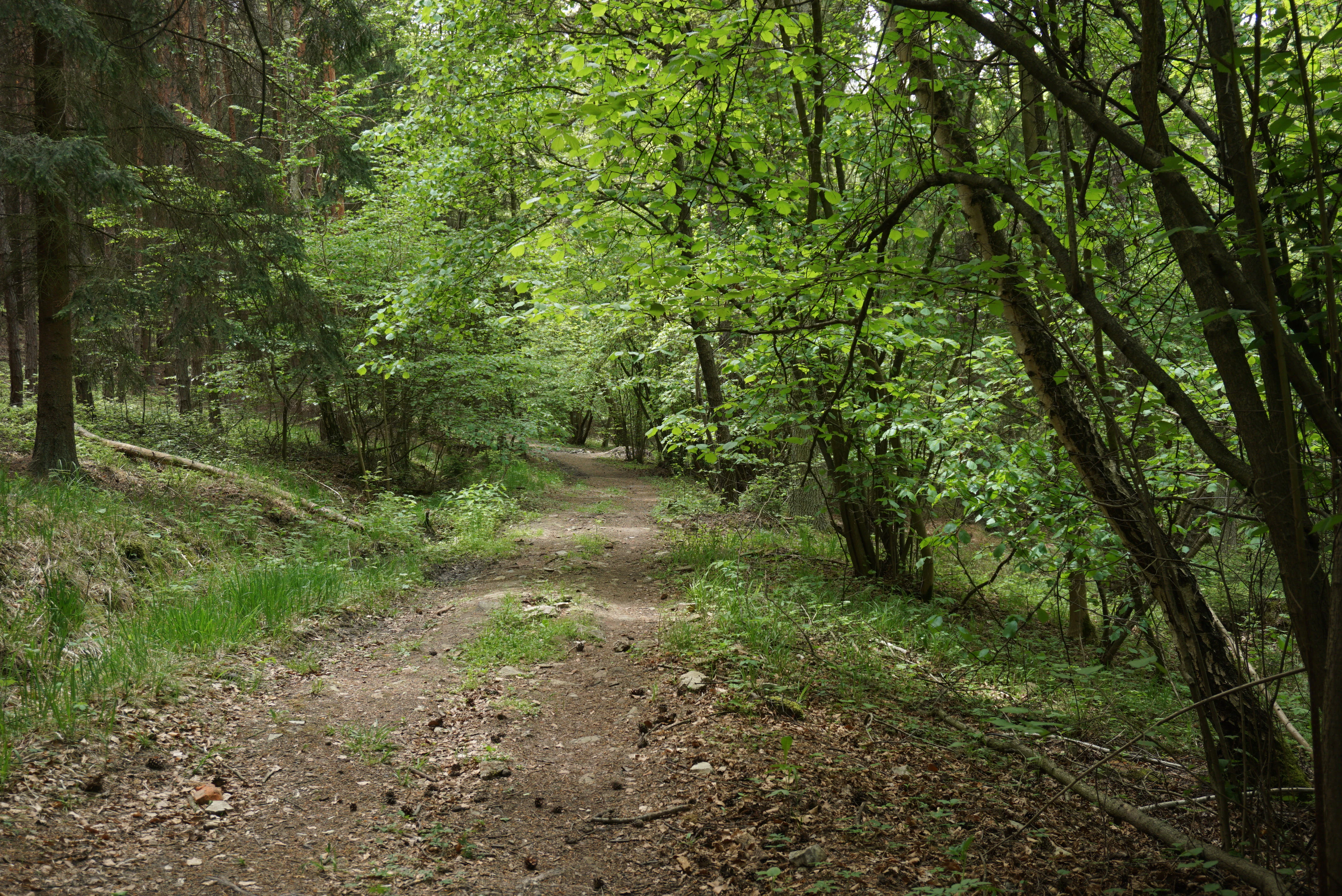
Smradovna Natural Monument: Samotin Creek valley
The Samotin Creek valley within the Smradovna Natural Monument, also known as Cikansky dolik

Smradovna history and protected-area timeline

Smradovna was formally designated as a natural monument on 10 June 2014 by the Regional Authority of the Central Bohemian Region. The decision followed growing recognition among Czech botanists and conservation biologists that the stream valleys northwest of Bílichov concentrated an unusually rich suite of habitats and rare species into a compact, still largely intact lowland catchment.

The site's protection reflects the broader shift in Czech nature conservation toward safeguarding smaller but ecologically irreplaceable sites, particularly those containing petrifying springs and alkaline fens, which had been heavily degraded or lost elsewhere in the agricultural lowlands. By designating Smradovna alongside the neighbouring national natural monument Cikánský dolík, authorities effectively created one of the better-protected lowland stream corridors in central Bohemia. The pre-existing cultural memory of the place, captured in its evocative folk name, already marked it as a distinctive locality long before formal protection arrived.

Smradovna landscape and geographic character

The landscape of Smradovna is shaped by gentle Bohemian stream valleys rather than dramatic relief. Elevations range from roughly 337 to 423 metres, but within that modest vertical span the terrain shifts noticeably from broader valley floors with mineral-rich seepage zones to steeper forested slopes and small ridgelines.

The Zichovecký and Samotínský streams carve narrow, often shaded valleys through the local countryside. Where the groundwater emerges, the slopes and valley bottoms become pocked with seepage springs and small fens, frequently marked by the pale, crusty deposits of travertine around moss cushions and saturated litter. Above these wet zones, the slopes carry mixed deciduous woodland, passing from richer calcareous beech stands on higher-pH soils to more open, acidophilous oak-dominated forest where the substrate is leaner and more acidic. Along the stream courses themselves, ash and alder form a denser, moister alluvial band. The whole setting reads as a small-scale, tightly integrated stream-valley ecosystem rather than an expansive scenic landscape.

Smradovna ecosystems, habitats, and plant life

The ecological interest of Smradovna rests on its dense mosaic of habitat types within a small area. The protected area combines calcareous spring environments, base-rich fens, and several distinct forest communities, each tied to specific hydrological and soil-chemical conditions.

The petrifying springs support a specialized spring biota adapted to permanently saturated, calcium-rich conditions. Downstream, where the waters spread and slow, alkaline fens develop on marly, base-rich substrates. These fens are among the most conservation-valuable features of the site, because such communities have declined sharply in the Czech agricultural lowlands. On the slopes above, the calcareous beech forests harbor spring geophytes and a rich herb layer typical of Central European limestone woodland, while the acidophilous oak forests on poorer soils contain a contrasting flora of more shade-tolerant and acid-tolerant species. Along the streams, ash-alder alluvial woodland provides yet another ecological zone, structurally and botanically distinct from the upland forests. The regular occurrence of both Cypripedium calceolus and Adenophora liliifolia ties the botanical value of the site to internationally recognized rare species.

Smradovna wildlife and species highlights

The narrow ecological focus of Smradovna lies primarily in its botanical rather than faunal character. The protected species highlighted in its designation are plants rather than animals: lady's slipper orchid (Cypripedium calceolus) and lily-of-the-valley bellflower (Adenophora liliifolia).

The habitat mosaic, however, supports a wider faunal community typical of central Bohemian lowland stream valleys. The combination of unpolluted streams, seepage springs, alluvial forests, and old-growth oak stands provides breeding and foraging habitat for amphibians associated with spring fens, invertebrates specialized in calcareous aquatic and wet-soil conditions, and bird species typical of Central European deciduous lowland forest. Old pedunculate oak stands in particular are valuable for saproxylic insects and cavity-nesting birds, while the alluvial ash-alder woodlands support wet-forest bird and invertebrate assemblages.

Smradovna conservation status and protection priorities

Smradovna's conservation significance lies in the concentration of habitats and species that have become rare or threatened in the modern Czech landscape. Petrifying springs with active travertine formation, alkaline fens, and old acidophilous oak forests are all habitat types that have experienced significant historical decline, and their coexistence in one compact site is unusual.

Designated as a natural monument under Czech law and classified as IUCN Category IV (habitat/species management area), the site is primarily managed to control adverse influences on its protected habitats and species. Protecting the hydrology of the spring system is central to this goal, because the travertine formation, fen development, and downstream alluvial woodland communities all depend on the continuing flow and chemistry of groundwater. The site's placement immediately south of the national natural monument Cikánský dolík reinforces its conservation role by extending the protected buffer along the same stream system, increasing the resilience of these habitat mosaics against external pressures.

Smradovna cultural meaning and human context

The cultural dimension of Smradovna is rooted in its folk name rather than in any built heritage. In Czech, 'smradovna' is a colloquial word for a foul-smelling or sulfurous place, and the name suggests that local communities long recognized the unusual, mineral-rich character of the springs and surrounding wet ground. Such springheads were often locally distinctive landmarks, associated with particular smells, waters, and traditional knowledge, even where they held no formal protection.

The valleys themselves, like much of central Bohemia, are embedded in a landscape of small villages, modest agricultural land, and mixed deciduous woodland, where human use of the land and natural stream systems has long overlapped. Modern protection of Smradovna reflects a shift toward recognizing these once-overlooked valley ecosystems as cultural as well as natural heritage.

Top sights and standout views in Smradovna

Smradovna's strongest points of distinction are its petrifying calcareous springs and the rare combination of alkaline fens, calcareous beech forest, old acidophilous oak forest, and ash-alder alluvial woodland in a single lowland valley system. Its protected populations of lady's slipper orchid and lily-of-the-valley bellflower add botanical weight to an already unusual habitat mosaic.

The site's compact footprint of roughly 156 hectares makes it highly accessible for studying how spring hydrology, soil chemistry, and forest type interact across a small catchment. Its direct ecological connection to the neighbouring national natural monument Cikánský dolík further increases its overall conservation value, creating a near-continuous protected stream corridor in the Central Bohemian countryside.

Best time to visit Smradovna

Smradovna is a lowland, deciduous-woodland site whose character shifts gently with the seasons. Spring is the most rewarding period for visitors interested in the botanical highlights defined by the protected designation: lady's slipper orchid flowers in late spring, and base-rich fens and calcareous beech forests come alive with spring geophytes. The woodland understory is at its most vivid early in the season, before the canopy fully closes.

In summer, the dense deciduous canopy shades the stream valleys, and the sheer springs and damp fens feel at their coolest and most refreshing. Autumn brings the warm colors of pedunculate oak and beech forest, while the structural contrast between richer and poorer soils on the slopes becomes easier to read. Winter visits are quiet and minimal but can reveal the underlying topography, the activity of the springs, and the outlines of the old oak stands more clearly than in any other season. Because the site is managed for conservation, visitors should follow the standard low-impact approach used across Czech natural monuments.


Monthly climate preview

Long term weather by month measurements for Stredocesky kraj protected terrain

Smradovna Climate Normals, Annual Temperature and Precipitation Records

Representative coordinate records show measured annual temperature and precipitation ranges across twelve distinct observation periods for Smradovna. Analyzing the complete monthly climate normals profile provides deeper statistical insight into historical long term meteorological patterns.
Annual mean8 °C
-3 °C19 °C
Jan-3°
Feb-1°
Mar
Apr
May13°
Jun17°
Jul19°
Aug18°
Sep13°
Oct
Nov
Dec-2°
Warmest month
July

18.7 °C

Coolest month
January

-2.6 °C

Wettest month
July

2.5 mm/day

Driest month
February

1.1 mm/day

Park location guide

Geography guide, regional context, and park location map for Smradovna

Smradovna park geography, regions, and map view in Czechia

Understand where Smradovna sits in Czechia through a broader geographic reading of the surrounding landscape, nearby location context, and its mapped position within the national park landscape.

How Smradovna fits into Czechia

Czech Republic is a landlocked Central European country with a population of approximately 10.9 million people. The nation was established as an independent state on January 1, 1993, following the dissolution of Czechoslovakia. Its capital and largest city is Prague, with other major urban centers including Brno, Ostrava, Plzeň, and Liberec.

Wider geography shaping Smradovna in Czechia

The Czech Republic is a landlocked country in Central Europe. It is bordered by Germany to the west, Austria to the south, Poland to the northeast, and Slovakia to the southeast. The landscape is predominantly hilly, with the territory covering 78,871 square kilometers.

Map view of Smradovna

Use this park location map to pinpoint Smradovna in Czechia, understand its exact geographic position, and read its mapped placement within the surrounding landscape more clearly.

Pigeon | © OpenStreetMap contributors

Location context for Smradovna

Středočeský kraj
Recorded earthquake history

Explore Historical Earthquake Records Associated with the Smradovna Landscape

Access a detailed, filterable dataset of recorded seismic activity tied to the Smradovna area. MoriAtlas provides a clear view of historical epicentre logs, including key magnitude and depth metrics for regional events, to support geographic study and research into the local seismic record.

Smradovna Earthquake History

Catalogued events

8 events

Strongest magnitude

Magnitude 3.8

Most recent event

Nov 15, 2004

This history includes earthquakes recorded inside the park or within 50 km of its borders

Explore the terrain, travertine springs, and forested valley habitats of Smradovna

Smradovna Photos and Landscape Scenery: Visualizing Protected Habitats

Visual records reveal the diverse terrain and rare habitat mosaic across the protected stream corridors of Smradovna. Photographic documentation highlights the petrifying springs, deciduous woodlands, and underlying topography that shape this Bohemian natural monument.

Smradovna Natural Monument: Samotin Creek valley

Park atlas

Compare adjacent stream valleys and connected conservation landscapes across the region

Explore Protected Areas and Parks Near Smradovna in Central Bohemia

Browse other protected areas and stream-valley reserves situated near Smradovna to analyze regional habitat patterns. Continuing into nearby conservation landscapes reveals broader geographic context across Central Bohemian terrain.
Nature reserveStředočeský kraj
About 1.8 km away#1 closest

South

Na Pilavě Nature Reserve: A Detailed Botanical Atlas of the Středočeský kraj Landscape

Mapping protected orchid habitats and forest flora in the Džbán highland.

Na Pilavě is a specialized nature reserve in the Kladno District, valued for its dense concentration of rare woodland orchids and the critically endangered black false hellebore. Set within the forested slopes of the Pilavské údolí, this protected area serves as a vital refuge for thermophilic plant communities and ancient deciduous forest flora.

Area
0.031 km²
Established
1969
IUCN
IV
Relief
Upland
Protected landscapeStředočeský kraj
About 9.6 km away#2 closest

West

Přírodní park Džbán: Geography and Protected Landscape Analysis of the Džbán Ridge

Forested highland and hydrological center of Středočeský kraj

Přírodní park Džbán encompasses a significant Cretaceous plateau and mixed-woodland system that functions as a triple watershed for three major river basins. The park preserves a rich mosaic of thermophilic plants and woodland fauna while maintaining the characteristic opuka geological features that define the vernacular architecture of this central Bohemian region.

Area
416 km²
Established
1994
Relief
Upland
Climate
Temperate
Natural monumentÚstecký kraj
9.9 km away#3 closest

Northeast

V hlubokém Natural Monument: Protected Calcareous Landscapes and Terrain in Ústecký kraj

A study of rare sesleria grasslands and opuka slope geography

V hlubokém serves as a significant protected site in the Czech Republic, encompassing twenty hectares of hillside defined by soft calcareous opuka rock. This natural monument is recognized for its rare sesleria grasslands and thermophilic plant assemblages that contrast with the surrounding woodland. The protected area forms a critical link in the broader geography of the Débeř valley, offering a clear example of localized botanical diversity supported by unique alkaline substrate conditions.

Area
0.202 km²
Established
1947
IUCN
III
Relief
Upland
Natural monumentStředočeský kraj
11 km away#4 closest

Southeast

Smečno Natural Monument: A Protected Woodland Ecosystem in Středočeský Kraj

Geography and conservation mapping in the Czech Republic

Located in the Kladno District, Smečno Natural Monument preserves mature deciduous trees essential for the survival of the hermit beetle. The site acts as a geographical link between distinct landform units, offering a clear look at how small, cavity-rich forest patches maintain ecological connectivity within the broader Central Bohemian landscape.

Area
0.772 km²
Established
2012
IUCN
IV
Relief
Upland
Natural monumentStředočeský kraj
About 12 km away#5 closest

South

Na Novém rybníce Natural Monument: Wetland Geography and Protected Area Atlas

A diverse protected mosaic of meadows and pond basins

Examine the detailed landscape of Na Novém rybníce, an ecologically rich natural monument in the Středočeský kraj. This protected area showcases a compact assemblage of pond, reed marsh, and rare fen meadow vegetation that illustrates the unique character of lowland Bohemian wetlands.

Area
0.054 km²
Established
1990
IUCN
III
Relief
Lowland
Natural monumentCentral Bohemian Region
About 13 km away#6 closest

Southeast

Smečenská rokle Natural Monument: Geological Gorge and Protected Landscape

Geological cross section in the Central Bohemian Region

Smečenská rokle is a compact natural monument featuring a deep erosional canyon cut into the marlstone plateau. The site offers a detailed stratigraphic view of Bohemian Cretaceous Basin sediments while preserving rare patches of scree and ravine forest within the broader agricultural environment of Central Bohemia.

Area
0.062 km²
Established
1987
IUCN
III
Relief
Upland
Natural monumentStředočeský kraj
About 13 km away#7 closest

East

Slánská hora Natural Monument: Volcanic Geography and Protected Hilltop Terrain in Central Bohemia

Detailed geological mapping of a Tertiary volcanic outlier and historic monument

Slánská hora functions as a significant geological landmark where basaltic vent remnants meet centuries of human history. This natural monument offers a window into the volcanic processes of the region through exposed columnar basalt and rock fissures. The site serves as a vital protected area, balancing remnants of warm-loving steppe vegetation and deciduous forest with the legacy of former quarries and ancient archaeological strata atop the Slaný ridge.

Area
0.022 km²
Established
1998
IUCN
III
Relief
Mountain
Natural monumentStředočeský kraj
About 15 km away#8 closest

Southeast

Vinařická hora Natural Monument: A Volcanic Geography and Protected Terrain Study

Key protected area and geological landmark in the Středočeský kraj region.

Vinařická hora is a compact, asymmetric hill serving as a vital natural monument for the study of Tertiary volcanic processes and dry-slope plant communities. Its abandoned quarries provide a clear stratigraphic record of ash and lava, while its summit offers panoramic views across the central Bohemian plateau. This site represents a convergence of deep geological history and specialized modern habitat preservation.

Area
0.684 km²
Established
1985
IUCN
III
Relief
Upland

Common questions about visiting, size, designation, and location context for Smradovna

Smradovna FAQs for park facts, access, geography, and protected area context

Find quick answers about Smradovna, including protected-area facts, park geography, trail and visitor context, and how the park fits into its surrounding country and regional landscape.
MoriAtlas Explorer

Continue Your Protected Areas Search Across the Global Atlas

Deepen your exploration by continuing the structured search for national parks and protected areas worldwide. Utilize the comprehensive filtering capabilities to compare different conservation landscapes and refine your understanding of global park geography. Discover more about the distribution and characteristics of protected natural areas.

Global natural geography