

Mori Atlas logo
Nature reserveSouth West Woodland Nature Reserve

Understanding the unique spatial distribution and woodland ecology of an expansive Australian conservation network

South West Woodland Nature Reserve: Mapping the Protected Forest Precincts of New South Wales

South West Woodland Nature Reserve stands as a significant conservation mosaic spanning inland New South Wales. This protected area comprises twenty-seven distinct precincts, stretching from the South Western Slopes to the Riverina and Murray Darling Depression. The reserve safeguards fragmented remnants of white cypress pine and eucalypt woodlands, preserving crucial inland forest habitats through a unified management framework focused on ecological integrity.

inland woodlandcypress pineeucalypt woodlandnature reservestrict nature reserveIUCN Category Ia

South West Woodland Nature Reserve

Nature reserve

Park overview

Structured park overview, official facts, and landscape profile for South West Woodland Nature Reserve

South West Woodland Nature Reserve park facts, protected area profile, and essential visitor context

Review the core facts for South West Woodland Nature Reserve, including designation, size, terrain, visitor scale, habitats, and operating context in one park-focused overview.

About South West Woodland Nature Reserve

South West Woodland Nature Reserve is one of the more distinctive formally protected areas in New South Wales because of its highly fragmented layout. Rather than a single tract of wilderness, the reserve is a collection of twenty-seven separate precincts that together cover roughly 13,840 hectares. These precincts extend from Peak Hill in the central west of the state down to Berrigan near the Murray River, a north to south extent of approximately 400 kilometres.

The reserve crosses three recognised bioregions of New South Wales: the South Western Slopes, the Riverina, and the Murray Darling Depression. This geographic spread means the reserve is not defined by a single landscape type, but by a family of related inland woodland communities that occur across a wide climatic and topographic gradient. The unifying thread across these precincts is the historical and ecological importance of native woodland dominated by white cypress pine and associated eucalypt species.

The reserve is administered by the NSW National Parks and Wildlife Service and is classified as a strict nature reserve under IUCN Category Ia. That classification reflects its purpose as a conservation area focused on protecting ecological values rather than on providing visitor amenities. The reserve is part of the broader New South Wales national park estate and was established to give long-term protection to woodlands that had previously been managed primarily for timber harvesting.

Quick facts and research context for South West Woodland Nature Reserve

South West Woodland Nature Reserve is a strict nature reserve in New South Wales, classified as IUCN Category Ia. It is managed by the NSW National Parks and Wildlife Service and covers approximately 13,840 hectares across twenty-seven separate precincts.

The reserve was created on 1 January 2011 under the National Park Estate (South Western Cypress Reservations) Act 2010, after the constituent state forests were reclassified from timber production lands to protected status. The precincts span multiple local government areas, including Bland, Carrathool, Cabonne, Parkes, Edward River, Murrumbidgee, and others, across the South Western Slopes, Riverina, and Murray Darling Depression regions.

The reserve includes habitat for threatened species such as the swift parrot, pink cockatoo, and yellow-bellied sheath-tailed bat, and it protects characteristic woodlands dominated by white cypress pine, grey box, mugga ironbark, red mallee, and bimble box.

Protection and recognition

Documented terrestrial protection scope, designation framework, and management context.

South West Woodland Nature Reserve Protection Status and International Recognition

South West Woodland Nature Reserve holds documented terrestrial protection status within a managed conservation framework. Official records outline the baseline designation scope and international recognition standing without extraneous administrative commentary.

Protection details

Protection scope
Terrestrial
Transboundary protection
No
Park context

Deeper park guide and search-rich context for South West Woodland Nature Reserve

South West Woodland Nature Reserve history, landscape, wildlife, and travel context

Explore South West Woodland Nature Reserve through its history, landscape character, ecosystems, wildlife, conservation priorities, cultural context, and seasonal travel timing in a structured park guide built for atlas discovery and search intent.

Why South West Woodland Nature Reserve stands out

South West Woodland Nature Reserve is best known for safeguarding remnants of inland cypress pine woodland and mixed eucalypt forest that were historically exploited for timber across inland southern New South Wales. The reserve is notable for its unusual structure: instead of a single large block, it is a mosaic of twenty-seven separate precincts scattered over a vast north to south distance. This patchwork character reflects how the original state forests were established and managed individually, and it makes the reserve an important example of how small, isolated woodland patches can be brought together under a unified conservation framework. Its position across the South Western Slopes, Riverina, and Murray Darling Depression also gives it ecological breadth, spanning a transition zone between wetter eucalypt forests and the drier mallee country further west.

South West Woodland Nature Reserve history and protected-area timeline

The precincts that make up South West Woodland Nature Reserve have a layered history that reflects the changing relationship between inland New South Wales forests and human use. Before European settlement, the lands lay within the country of the Wiradjuri and Ngiyampaa Aboriginal peoples. Some precincts contain registered Aboriginal sites, and further survey and engagement with Aboriginal communities is needed to fully appreciate the cultural significance of these landscapes.

The formal reservation history of the land began in the early twentieth century. The individual precincts were gazetted as state forests in stages between 1913 and 1977 and were managed for many decades by the Forestry Commission of NSW for logging and timber production. The most intensive activity focused on white cypress pine, a slow-growing native conifer that was highly valued for durable construction timber.

By the early twenty-first century, recognition of the ecological values of these woodlands grew, and concerns about the long-term sustainability of further logging led to legislative action. The precincts were reclassified as a nature reserve on 1 January 2011 under the National Park Estate (South Western Cypress Reservations) Act 2010. Although the reserve was created as a single legal entity, the names of the original state forests continue to be used for each precinct, preserving the historical identity of the constituent areas.

South West Woodland Nature Reserve landscape and geographic character

The landscape of South West Woodland Nature Reserve is defined by the gently undulating terrain typical of inland southern New South Wales. Across its precincts, the reserve captures the transition zone between the slightly higher and cooler South Western Slopes and the flatter, drier plains of the Riverina and Murray Darling Depression.

Vegetation across the precincts is dominated by open woodlands rather than dense forests, with widely spaced trees forming a tall, sparse canopy over grassy or shrubby understoreys. In many precincts, white cypress pine forms a key structural element of the woodland, alongside eucalypts such as grey box, mugga ironbark, bimble box, and inland red box. In the drier, more western precincts, mallee-form eucalypts such as red mallee become more prominent, reflecting the shift toward semi-arid conditions.

The scattered, patchy layout of the reserve gives it a distinctive landscape character. Instead of a continuous wilderness, visitors to the region encounter a series of small woodland islands set within a broader agricultural and pastoral matrix. This landscape pattern is itself a reflection of how the original state forests were embedded within a working rural landscape.

South West Woodland Nature Reserve ecosystems, habitats, and plant life

Ecologically, South West Woodland Nature Reserve is significant for protecting remnants of inland woodland communities that have been extensively cleared or modified elsewhere in southern New South Wales. White cypress pine woodlands in particular have been heavily reduced across their natural range due to historical land clearing and selective logging, making surviving stands in the reserve important for biodiversity conservation.

The woodland communities vary across the reserve in response to soils, rainfall, and local climate. On better-watered sites, mixed eucalypt woodlands with grey box and mugga ironbark dominate, with white cypress pine often present as a mid-storey or co-dominant tree. On drier and sandier sites, particularly toward the west, the vegetation shifts toward mallee eucalypts and more shrub-dominated understoreys. Native ground-layer plants such as the pine donkey orchid and Wakool spear-grass occur within these woodland communities.

The reserve also experiences ecological pressure from a range of introduced weed species. African boxthorn, white horehound, prickly pear, Noogoora and Bathurst burrs, Patterson's curse, and various thistles are all recorded, and management of these weeds is part of the ongoing challenge of maintaining the integrity of the native woodland communities.

South West Woodland Nature Reserve wildlife and species highlights

The wildlife values of South West Woodland Nature Reserve are closely tied to the structure and floristics of its inland woodlands, which provide habitat for a variety of bird and mammal species, including several that are listed as threatened under the NSW Biodiversity Conservation Act 2016.

Seven threatened bird species have been recorded within the reserve, including the swift parrot, little eagle, brown treecreeper, pink cockatoo, speckled warbler, grey-crowned babbler, and varied sitella. Other notable birds present include the white-browed babbler, apostlebird, superb parrot, barking owl, black-chinned honeyeater, diamond firetail, little lorikeet, hooded robin, and shy heathwren. Together, these species highlight the importance of mature hollow-bearing trees and well-developed understorey layers for woodland-dependent fauna.

Mammal diversity is more limited but still includes threatened species. The yellow-bellied sheath-tailed bat and the little pied bat have been recorded within the reserve, reflecting the importance of older woodlands for tree-hollow-roosting fauna. Like many protected areas in eastern Australia, the reserve also faces ongoing pressure from introduced pest species such as the European red fox, feral pigs, European rabbits, feral goats, and feral cats, which influence wildlife management priorities across the precincts.

South West Woodland Nature Reserve conservation status and protection priorities

South West Woodland Nature Reserve plays an important conservation role in protecting fragmented remnants of inland woodland in a landscape that has otherwise been heavily modified by agriculture. Because the constituent precincts were previously managed as state forests, their transfer to nature reserve status represents a significant long-term shift in management emphasis from timber production to ecological preservation.

The reserve is classified as a strict nature reserve under IUCN Category Ia. This classification denotes a protected area managed mainly for scientific research and ecosystem protection, with limited human intervention beyond what is necessary to maintain ecological values. It reflects the intent that these woodlands be conserved for their biodiversity and scientific significance rather than for intensive public recreation.

The reserve contributes to the survival of several threatened species and vegetation communities listed under New South Wales biodiversity legislation. Protecting these woodlands also helps maintain landscape connectivity, soil stability, and habitat continuity in a region where much of the original native vegetation has been lost or simplified. Ongoing conservation challenges include managing invasive weeds and introduced herbivores, and ensuring that the fragmented nature of the reserve does not undermine its long-term ecological viability.

South West Woodland Nature Reserve cultural meaning and human context

The lands that make up South West Woodland Nature Reserve lie within the traditional country of the Wiradjuri and Ngiyampaa Aboriginal peoples. Some precincts have been surveyed and contain registered Aboriginal sites, providing physical evidence of long-standing cultural connections to these inland woodland landscapes.

However, the source material notes that further study and engagement with Aboriginal communities is needed to fully understand the cultural and historic significance of the reserve. This indicates that the cultural heritage values of the area are recognised, but are still being more thoroughly documented and interpreted in partnership with traditional owners.

Beyond Aboriginal heritage, the reserve holds a cultural dimension through its recent history as a system of state forests. For many decades, these woodlands were a working landscape associated with the timber industry, forestry workers, and rural communities across inland New South Wales. The transition of the precincts into a nature reserve therefore represents both an ecological and a cultural shift in how the land is recognised and valued.

Top sights and standout views in South West Woodland Nature Reserve

South West Woodland Nature Reserve is distinguished by its unusual structure as a collection of twenty-seven separate precincts spread across roughly 400 kilometres of inland New South Wales, all unified under a single conservation framework.

Its principal ecological value lies in the protection of white cypress pine and eucalypt woodlands, including grey box, mugga ironbark, bimble box, red mallee, and inland red box communities that are now reduced or fragmented elsewhere in the landscape. The reserve supports threatened species such as the swift parrot, pink cockatoo, speckled warbler, and yellow-bellied sheath-tailed bat, underscoring its role in conserving woodland biodiversity in a highly cleared region.

Best time to visit South West Woodland Nature Reserve

South West Woodland Nature Reserve is a strict nature reserve under IUCN Category Ia, which means public access and visitor infrastructure are limited. As a result, the question of when to visit is less about tourism seasons and more about the broader seasonal character of inland southern New South Wales woodland.

Spring is generally a productive time for experiencing inland woodlands in this region, when milder temperatures bring out native wildflowers, increased bird activity, and a more visible ground layer. Autumn also offers pleasant conditions and can be a quieter period in the landscape. Summer in inland New South Wales is typically hot and dry, while winter can bring cooler temperatures and frosts, particularly in the more southern precincts near Berrigan.

Because the reserve is primarily managed for conservation rather than recreation, any visit should be approached in line with the access conditions set by the NSW National Parks and Wildlife Service, and visitors should be prepared for the climatic variability typical of inland Australia.
Monthly climate preview

Long term temperature and precipitation records measured across representative regional coordinates

South West Woodland Nature Reserve Climate Normals and Annual Weather Patterns

Representative coordinate records show measured variations in monthly average temperatures and precipitation values throughout the year. Reviewing the complete twelve month profile provides detailed climate normal data for South West Woodland Nature Reserve.
Annual mean16 °C
7 °C25 °C
Jan25°
Feb23°
Mar20°
Apr16°
May11°
Jun
Jul
Aug
Sep12°
Oct16°
Nov19°
Dec22°
Warmest month
January

24.5 °C

Coolest month
July

6.9 °C

Wettest month
February

2.1 mm/day

Driest month
April

1 mm/day

Park location guide

Geography guide, regional context, and park location map for South West Woodland Nature Reserve

South West Woodland Nature Reserve park geography, regions, and map view in Australia

Understand where South West Woodland Nature Reserve sits in Australia through a broader geographic reading of the surrounding landscape, nearby location context, and its mapped position within the national park landscape.

How South West Woodland Nature Reserve fits into Australia

Australia is a constitutional monarchy and federal parliamentary democracy comprising six states and ten territories. With a population of nearly 28 million, it is one of the world's most urbanised countries, with most people concentrated on the eastern seaboard. The country has a high Human Development Index and is known for its cultural diversity, ancient Aboriginal heritage, and unique wildlife.

Wider geography shaping South West Woodland Nature Reserve in Australia

Australia occupies the entire Australian continent, the island of Tasmania, and numerous smaller islands. It is the world's flattest and driest inhabited continent, featuring vast deserts in the interior (the Outback), tropical rainforests along the eastern coast, and a coastline bordering the Indian and Pacific Oceans.

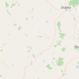
Map view of South West Woodland Nature Reserve

Use this park location map to pinpoint South West Woodland Nature Reserve in Australia, understand its exact geographic position, and read its mapped placement within the surrounding landscape more clearly.

Pigeon | © OpenStreetMap contributors

Location context for South West Woodland Nature Reserve

New South Wales
Park atlas

Compare regional woodland remnants and connected conservation landscapes across inland New South Wales

Explore Parks Near South West Woodland Nature Reserve and Surrounding Protected Areas

Continue browsing other protected areas and regional reserves located near South West Woodland Nature Reserve. Comparing adjacent woodland patches and eucalypt forests provides deeper geographic context for the surrounding South Western Slopes and Riverina bioregions.
National parkNew South Wales
About 13 km away#1 closest

Northwest

Goobang National Park: Detailed Geographic and Protected Landscape Exploration

Mapped Boundaries and Natural Terrain in New South Wales

Discover the specific geographic features and protected boundaries of Goobang National Park. This entry offers an atlas-focused perspective, highlighting its role as a national park within New South Wales and providing foundational data for understanding its natural landscape and regional setting. Dive into a structured exploration of its mapped terrain and protected status.

Area
421 km²
Established
1995
IUCN
II
Relief
Upland
A watercolor painting of rolling green hills and mountains against a white background with pale pink and yellow washes.
Nature reserveNew South Wales
About 29 km away#2 closest

Southeast

Borenore Karst Conservation Reserve: Exploring Limestone Caves and Volcanic Geology

Protected karst landscapes and fossil heritage in New South Wales

Borenore Karst Conservation Reserve offers a dense concentration of limestone features, including the notable Tunnel Cave and expansive fossil-rich sediments. Its geographic identity is defined by the striking contrast between its sedimentary core and the surrounding volcanic terrain of the Central Tablelands, providing a distinct site for investigating regional earth sciences and subterranean ecology.

Area
1.36 km²
Established
1997
IUCN
III
Relief
Upland
National parkNew South Wales
About 37 km away#3 closest

Southwest

Nangar National Park: Australian National Park Geography and Mapped Boundaries

Explore the protected landscape within New South Wales.

Nangar National Park is a key protected area situated in New South Wales, Australia, offering a valuable point for geographic discovery. This page details its status as a national park, providing insight into its mapped boundaries and its role within the regional landscape. Users can utilize this information to understand the park's specific geographic context and its contribution to the broader atlas of Australia's protected lands.

Area
94 km²
Established
1983
IUCN
II
Relief
Mountain
Nature reserveNew South Wales
About 53 km away#4 closest

Northeast

Wellington Caves Nature Reserve: Mapping Limestone Formations and Pleistocene Fossil Sites

Geological atlas of subterranean karst landscapes in New South Wales

The Wellington Caves reserve features a rich subterranean geography shaped by water working through Devonian limestone. Explore the site's mapped network of chambers, including Cathedral Cave and its massive Altar Rock, alongside historic fossil deposits that have shaped Australian paleontology since the 1830s. This protected landscape offers a unique look at karst evolution and subterranean lake systems within the Australian bush.

Established
1884
Visitors
35K annual
Relief
Upland
Scope
Terrestrial
National parkNew South Wales
About 73 km away#5 closest

South

Conimbla National Park: Protected Landscape Atlas and Regional Geography

Mapped boundaries and terrain within New South Wales.

Examine the protected landscape of Conimbla National Park, a designated national park situated in New South Wales, Australia. This entry provides focused geographic context, detailing its mapped boundaries and the regional terrain. It serves as a valuable resource for understanding the park's identity within the national atlas and its specific place in the Australian landscape.

Area
84.71 km²
Established
1980
IUCN
II
Relief
Upland
National parkAustralia
About 105 km away#6 closest

Northeast

Yarrobil National Park: Australia's Protected Landscape for Geographic Discovery

Explore its national park designation and mapped regional context.

Yarrobil National Park stands as a distinct protected landscape within Australia, identified as a national park. Its geographic significance lies in its contribution to the nation's atlas of conservation areas. This page focuses on providing a clear understanding of the park's identity, its environmental setting, and how its mapped boundaries fit into the broader regional geography of Australia, enabling structured exploration for enthusiasts of protected areas and natural landscapes.

Area
13.22 km²
Established
2005
IUCN
II
Relief
Upland
Natural monumentNew South Wales
About 111 km away#7 closest

Southeast

Abercrombie Caves: Protected Karst Landscape and Geological Monument in New South Wales

Exploration of karst formations and cave morphology

Abercrombie Caves preserve a sophisticated limestone karst system within the Central West region of New South Wales. The reserve is anchored by The Archway, a massive natural bridge sculpted by water erosion, alongside various chambers including King Solomon's Temple and Bushranger's Cave. This natural monument highlights the interplay between rugged range geography, solutional cave development, and the site's enduring historical significance as a former gold-mining and bushranger landscape.

Area
14.34 km²
Established
1997
IUCN
III
Relief
Upland
National parkNew South Wales
About 112 km away#8 closest

East

Turon National Park National Park: Protected Landscape and Geographic Atlas Details

Mapped boundaries and regional context within New South Wales.

Turon National Park is a protected national park in New South Wales, Australia, offering a distinct geographic identity for atlas exploration. This entry focuses on its mapped boundaries, natural terrain, and its role as a conservation landscape. Users can discover its specific features and regional context, enhancing their understanding of Australia's protected areas.

Established
2002
IUCN
II
Relief
Mixed relief
Climate
Temperate

Common questions about visiting, size, designation, and location context for South West Woodland Nature Reserve

South West Woodland Nature Reserve FAQs for park facts, access, geography, and protected area context

Find quick answers about South West Woodland Nature Reserve, including protected-area facts, park geography, trail and visitor context, and how the park fits into its surrounding country and regional landscape.
MoriAtlas Explorer

Continue Your Protected Areas Search Across the Global Atlas

Deepen your exploration by continuing the structured search for national parks and protected areas worldwide. Utilize the comprehensive filtering capabilities to compare different conservation landscapes and refine your understanding of global park geography. Discover more about the distribution and characteristics of protected natural areas.

Global natural geography