Mori Atlas logo
Nature reserveStärtchen und Freibusch

A vital glacial valley habitat featuring old-growth woodland and diverse wetland ecosystems

Stärtchen und Freibusch Nature Reserve: Mapped Geography and Protected Forest Landscapes in Brandenburg

(Naturschutzgebiet Stärtchen und Freibusch)

Stärtchen und Freibusch stands as a significant nature reserve situated along the Baruth glacial valley in Brandenburg. This protected landscape encompasses a mosaic of old-growth forest, deadwood habitats, and moisture-rich fen pockets formed by post-glacial geological processes. The reserve serves as a critical node in a broader regional biotope network, supporting rare saproxylic beetles, diverse bat species, and breeding birds across its unique sandy and peat-influenced terrain.

nature reserveBrandenburgBaruth glacial valleyprotected forestFFH siteold-growth forest

Stärtchen und Freibusch

Nature reserve

Park overview

Structured park overview, official facts, and landscape profile for Stärtchen und Freibusch Nature Reserve

Stärtchen und Freibusch Nature Reserve park facts, protected area profile, and essential visitor context

Review the core facts for Stärtchen und Freibusch Nature Reserve, including designation, size, terrain, visitor scale, habitats, and operating context in one park-focused overview.

About Stärtchen und Freibusch Nature Reserve

Stärtchen und Freibusch occupies a transitional position within Brandenburg's southern glacial landscape, where Ice Age deposits shaped distinct soil and hydrological conditions. The reserve lies just north-northwest of the village of Holbeck and is bordered by the Hollertgraben watercourse and an oxbow to the east, with the L 73 state road running nearby. The IUCN Category IV designation reflects its focus on active habitat and species management rather than strict wilderness preservation, balancing conservation with the long forestry traditions of the region.

Ecologically, the site functions as a representative fragment of the forest types that would naturally develop across the Baruth glacial valley. The substrate is dominated by nutrient-poor gley soils, peat, and some brown earth on central alluvial flats, with small dunes appearing in the southern part of the area. Groundwater emerges at numerous points within the reserve, and small standing waters along with partially naturalized ditches contribute additional wetland habitat character. A small artificial pond lies within a larch plantation, and the Schlossteich pond in the southwestern part is surrounded by a boggy birch pioneer forest.

The reserve's value is magnified by its integration into a wider east-west biotope network connecting nearby protected woodlands such as the Zarth nature reserve, the Schöbendorfer Busch, and areas near Glashütte-Mochheide. This connectivity supports wildlife movement and enables populations of sensitive species to persist across the broader landscape. Some old trees within the FFH portion of the site are individually designated as natural monuments, underscoring their ecological and cultural importance.

Quick facts and research context for Stärtchen und Freibusch Nature Reserve

Stärtchen und Freibusch is a nature reserve located in the Nuthe-Urstromtal municipality within the Teltow-Fläming district of Brandenburg, Germany. Established by legal ordinance on 10 June 2002, it is managed as an IUCN Category IV Habitat/Species Management Area and is part of the Natura 2000 network as a designated Fauna-Flora-Habitat (FFH) site. The reserve covers roughly 179 hectares of woodland, with about 51 hectares of that area recognized as protected forest, including a substantial old-growth deadwood section left as a strict total reserve.

Protection and recognition

Documented conservation status and international designation records

Stärtchen und Freibusch Protection Status and Natura 2000 Recognition

Stärtchen und Freibusch holds documented protection status and official Natura 2000 recognition within European conservation frameworks. Structured records outline the administrative designation history and management scope associated with this protected area.
Park context

Deeper park guide and search-rich context for Stärtchen und Freibusch Nature Reserve

Stärtchen und Freibusch Nature Reserve history, landscape, wildlife, and travel context

Explore Stärtchen und Freibusch Nature Reserve through its history, landscape character, ecosystems, wildlife, conservation priorities, cultural context, and seasonal travel timing in a structured park guide built for atlas discovery and search intent.

Why Stärtchen und Freibusch Nature Reserve stands out

The reserve is recognized for its near-natural forest composition that closely approximates the potential natural vegetation of the Baruth glacial valley. It preserves stands of birch-oak woodland, alder lowland forest, and oak-hornbeam forest on nutrient-poor, sandy, and peat-influenced soils. A defining feature is the significant share of old-growth and deadwood forest maintained as a total reserve, which provides critical habitat for rare saproxylic beetles such as the great capricorn beetle and the hermit beetle. The area is also notable for protected plant species such as royal fern and hepatica, and for bird species including common crane, turtle dove, and wryneck.
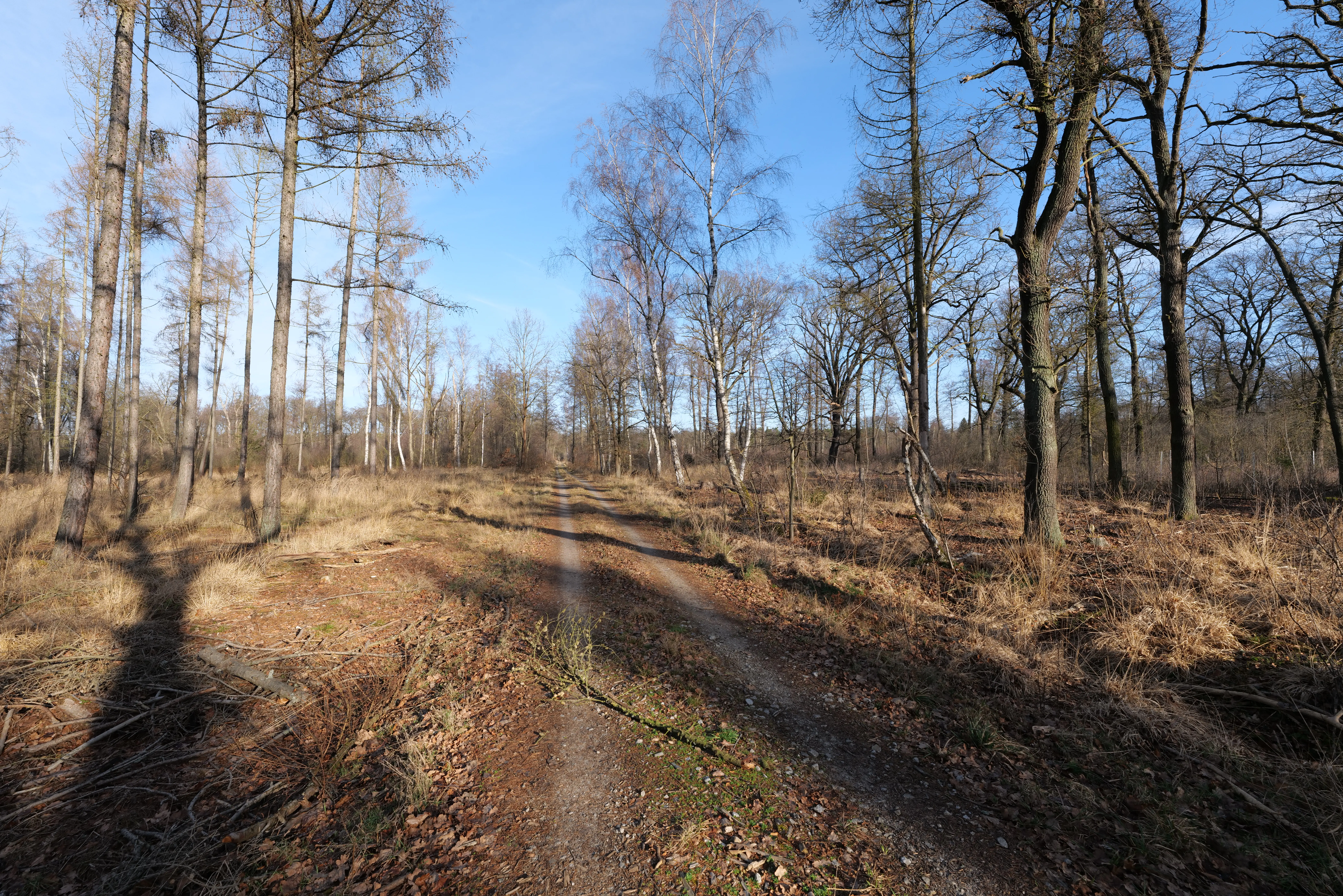
A dirt path leads into a sparse deciduous forest under a clear blue sky, with bare trees and dry grassy ground in a winter setting.
A forest trail winds through the Stärtchen und Freibusch nature reserve in winter.

Stärtchen und Freibusch Nature Reserve history and protected-area timeline

Stärtchen und Freibusch has been used as woodland for centuries because of its relatively infertile soils, which made it unsuitable for early agricultural development. The forest historically belonged to the large Stülpe estate, whose owners cleared a neighboring alder swamp known as the Hollert in the first half of the 19th century. The cleared land was used temporarily for grazing, but this practice was discontinued after 1840 and the area returned to its wooded character.

During the 20th century, parts of the site were also shaped by plantation forestry, with non-native tree species introduced alongside native oaks, lindens, and pines. Drainage measures (Melioration) affected local groundwater levels in past decades. The site's modern protection history began with the formal nature reserve ordinance issued on 10 June 2002, which established it as an IUCN Category IV protected landscape and embedded parts of the area into the European Natura 2000 FFH network. Today the woodland is managed largely by the Baruth forestry office, while the Lindhorst district of the Belzig state forestry office operates hunting rights on parts of the property.

Stärtchen und Freibusch Nature Reserve landscape and geographic character

The reserve lies on the southern margin of the Baruth Urstromtal, the broad glacial valley system formed during the Weichselian glaciation. The substrate reflects this ice-age legacy, with fluvioglacial sands, Holocene fen deposits, and small dunes punctuating the otherwise flat terrain to the south. The combination of gley soils, peat, and occasional brown earth gives the area a patchwork character of moist lowland pockets interspersed with slightly drier sandy flats.

Hydrology is a defining feature of the landscape. Groundwater emerges at many points within the reserve, and small open waters together with partly near-natural ditches interrupt the closed forest canopy. The eastern boundary follows the Hollertgraben waterway, and an old river arm of that system penetrates into the protected area itself. In the western portion, the small Schlossteich pond is bordered by damp birch pioneer woodland, lending the area a quiet, marshy atmosphere.

Climatically, the reserve sits at the meeting point between the more maritime Atlantic influences of western Germany and the more continental climate of the east. Average annual temperatures hover around 9 degrees Celsius, and yearly precipitation falls between roughly 530 and 550 millimeters, conditions that favor the mosaic of wet and moderately dry forest communities typical of the Baruth valley.
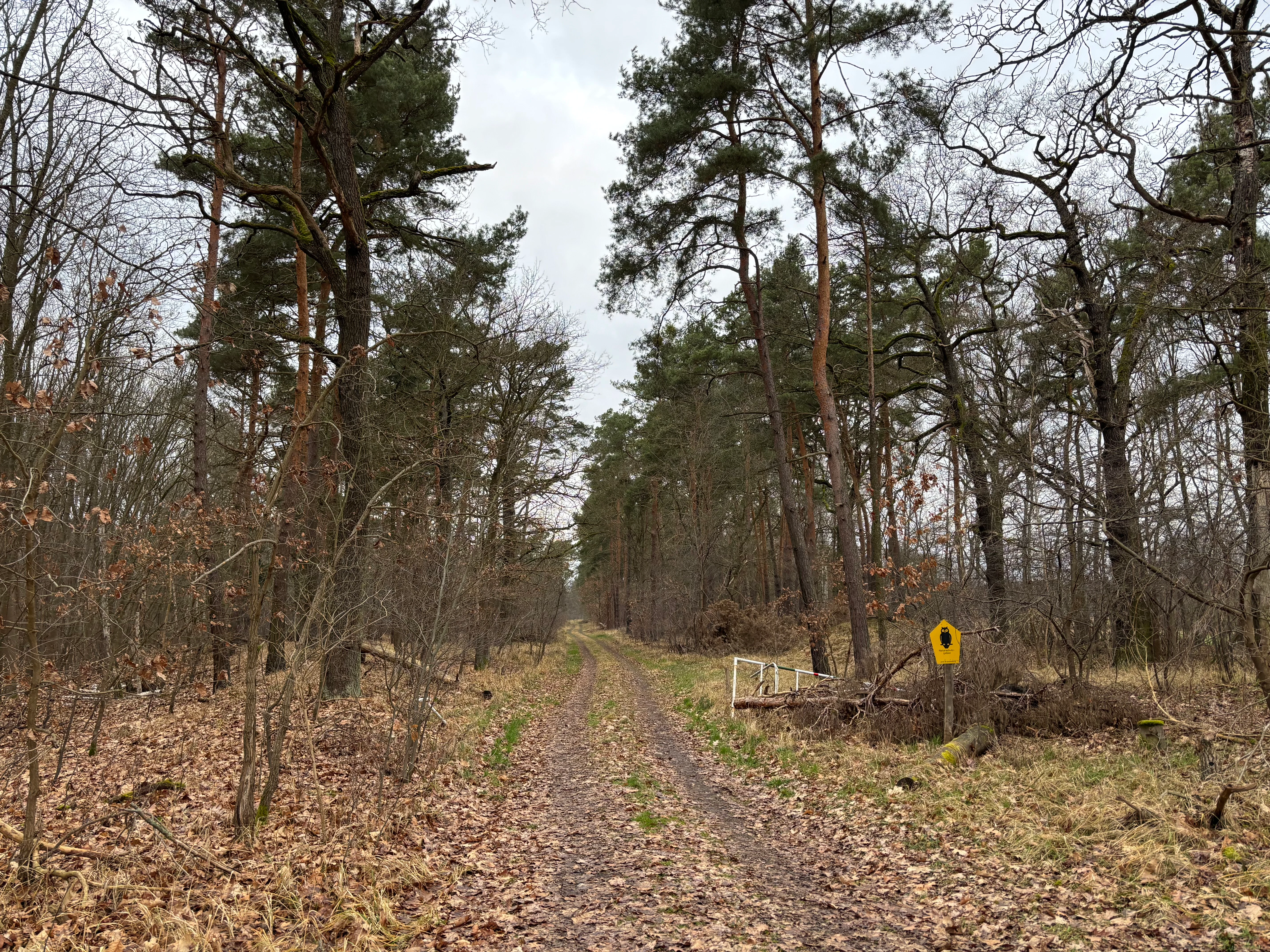
A dirt trail stretches into the distance, flanked by tall pine and deciduous trees in a sparse forest setting under an overcast sky.
A narrow dirt path leading through the woodland of the Stärtchen und Freibusch nature reserve.

Stärtchen und Freibusch Nature Reserve ecosystems, habitats, and plant life

Stärtchen und Freibusch is ecologically significant because it preserves a near-natural forest community that closely mirrors the potential natural vegetation of the surrounding glacial valley. The most representative woodland types are birch-oak forests with purple moor grass on the poorer sandy flats, alongside oak-hornbeam communities on slightly richer soils, and alder-dominated lowland forests in the wetter northern and eastern sections.

The reserve's flora is unusually rich for a relatively small site. Notable protected plants include royal fern (Osmunda regalis), hepatica, water feather, and herb Paris. A particularly striking feature is a colorful spring herb layer that blooms visibly across the forest floor before the canopy fully leafs out. The site also documents historical afforestation with non-native conifers such as Douglas fir, spruce, and Weymouth pine, alongside exotic broadleaves like red oak and hybrid poplars.

Wetland and small water features add further ecological complexity. The reserve contains several small standing waters, including a man-made pond within a larch plantation, partial bog communities around the Schlossteich, and small dunes that introduce microclimatic variation into the otherwise low-relief terrain. Together, these elements create a layered habitat structure that supports biodiversity across plants, invertebrates, and vertebrates.

Stärtchen und Freibusch Nature Reserve wildlife and species highlights

The immediate availability of old trees and substantial deadwood has made Stärtchen und Freibusch a strong refuge for saproxylic beetles and other woodland invertebrates, including the protected great capricorn beetle and the hermit beetle. Two individual trees within the FFH zone are designated as natural monuments, in part because of their value to such specialist species.

Bats are particularly well represented, with 15 recorded species. Notable species include Bechstein's bat, the supragular bat, the grey long-eared bat, the northern bat, and the particolored bat. The noctule and the lesser noctule use the area as a nursery roost site, suggesting strong seasonal importance for the local bat population.

Amphibians and reptiles also use the damp forest habitats, with confirmed records of common toad as occasional findings, tree frog between 1997 and 2009, possibly the great crested newt based on older data, and a sand lizard documented in 2012. Birds add another important layer of biodiversity: common crane, turtle dove, and wryneck are highlighted in the reserve's ordinance as specially protected breeding species, while black stork once bred on site in 2000 and honey buzzard was recorded repeatedly between 2002 and 2011. Otters also use the wetter parts of the reserve.

Stärtchen und Freibusch Nature Reserve conservation status and protection priorities

Stärtchen und Freibusch holds its high conservation value primarily because of the preservation of near-natural woodland on soils that have historically been kept productive as forest. The strict total reserve, where roughly 35 hectares of old-growth and deadwood are left largely untouched, acts as a biodiversity anchor for invertebrates, fungi, and cavity-dependent species that depend on decaying wood.

The reserve's integration into the Natura 2000 network, through its FFH designation, brings European-level recognition and obligations to maintain or improve habitat quality for qualifying species. At national and regional levels, the ordinance of 10 June 2002 provides a legal framework that protects specific plant and bird species and requires management consistent with the site's ecological character.

Beyond direct species protection, the reserve contributes to a regional biotope network that links several forest reserves across the Teltow-Fläming district in an east-west corridor. This landscape-scale connectivity ensures gene flow and dispersal opportunities for wildlife across a much wider area than any single reserve could secure on its own.

Stärtchen und Freibusch Nature Reserve cultural meaning and human context

The reserve's surrounding landscape carries a layered cultural imprint that reaches back into early medieval times. Archaeological investigations along the western border identified a deserted medieval settlement, a low hill castle site known locally as Schlossberg, and a moat-and-embankment system north of the Schlossteich, indicating former occupation of this otherwise forested terrain.

In more recent centuries, the land has been shaped by large estate ownership and traditional forestry practices, and parts of the forest remain today under state management with some private holdings. The FlämingWalk long-distance trail's Großer Rundweg route passes around the reserve, reflecting an effort to make the protected landscape accessible for low-impact outdoor recreation without compromising its conservation purpose.

Top sights and standout views in Stärtchen und Freibusch Nature Reserve

Stärtchen und Freibusch stands out for the unusual density of valuable habitats packed into a compact forest area: a strict total reserve of old-growth and deadwood, fen and bog communities, small dunes, open water bodies, and an extensive species list encompassing protected plants, saproxylic beetles, fifteen bat species, amphibians, and rare breeding birds.

Its role as a stepping stone in a wider east-west biotope network across Teltow-Fläming means that even modest-size reserves like this one carry disproportionate ecological importance for the broader region.

Best time to visit Stärtchen und Freibusch Nature Reserve

Spring is widely regarded as the most rewarding season, when the reserve's understory produces a notably colorful bloom before the canopy fully shades the forest floor. Late spring and early summer also tend to be favorable for observing breeding birds, while the still, damp conditions of autumn can bring misty atmospheric quality to the woodland and easier viewing of deadwood and lichen communities.

Wet or cool weather highlights the area's hydrological character, since groundwater emerges at many points and small pools are scattered through the reserve. Visitors prioritizing bat encounters, on the other hand, generally benefit from warmer evenings in late spring and summer when bat activity peaks.

Monthly climate preview

Long-term representative point measurements tracking monthly temperature and precipitation rhythm

Stärtchen und Freibusch Climate Normals and Measured Annual Temperature Patterns

Historical data records monthly temperature and precipitation variations across the representative park coordinate from 1991 to 2020. Reviewing the complete twelve-month climate profile reveals detailed patterns and long-term averages for this protected area.
Annual mean10 °C
-1 °C20 °C
Jan-1°
Feb
Mar
Apr
May14°
Jun18°
Jul20°
Aug20°
Sep15°
Oct
Nov
Dec
Warmest month
July

20.3 °C

Coolest month
January

-0.7 °C

Wettest month
July

2.4 mm/day

Driest month
April

1.1 mm/day

Park location guide

Geography guide, regional context, and park location map for Stärtchen und Freibusch Nature Reserve

Stärtchen und Freibusch Nature Reserve park geography, regions, and map view in Germany

Understand where Stärtchen und Freibusch Nature Reserve sits in Germany through a broader geographic reading of the surrounding landscape, nearby location context, and its mapped position within the national park landscape.

How Stärtchen und Freibusch Nature Reserve fits into Germany

Germany is a federal republic in Western and Central Europe with a population of over 83 million across sixteen constituent states. It is Europe's largest economy by nominal GDP and a major global exporter and importer. The capital is Berlin, and the country borders Denmark, Poland, Czech Republic, Austria, Switzerland, France, Luxembourg, Belgium, and the Netherlands.

Wider geography shaping Stärtchen und Freibusch Nature Reserve in Germany

Germany is located in Western and Central Europe, spanning 357,022 km². It borders Denmark to the north, Poland and the Czech Republic to the east, Austria and Switzerland to the south, and France, Luxembourg, Belgium, and the Netherlands to the west. The country has coastlines on the Baltic Sea and North Sea to the north, with the Alps located in the southern region.

Map view of Stärtchen und Freibusch Nature Reserve

Use this park location map to pinpoint Stärtchen und Freibusch Nature Reserve in Germany, understand its exact geographic position, and read its mapped placement within the surrounding landscape more clearly.

Pigeon | © OpenStreetMap contributors

Location context for Stärtchen und Freibusch Nature Reserve

Brandenburg

Visualizing the glacial valley terrain, wet woodlands, and old-growth habitats of Brandenburg

Stärtchen und Freibusch Photos and Landscape Scenery

Browse detailed photographs showcasing the distinct glacial valley terrain, dense wet woodlands, and old-growth forest habitats across Stärtchen und Freibusch. Visual documentation reveals the natural topography, wetland patches, and protected flora that define the character of this protected area.

A dirt path leads into a sparse deciduous forest under a clear blue sky, with bare trees and dry grassy ground in a winter setting.

A square metal sign mounted on a wooden post in a forest, marking a protected natural area with German text.

A dirt trail stretches into the distance, flanked by tall pine and deciduous trees in a sparse forest setting under an overcast sky.

Park atlas

Compare adjacent glacial valley reserves and regional forest habitats.

Parks Near Stärtchen und Freibusch and Connected Protected Landscapes

Visitors exploring Stärtchen und Freibusch can browse nearby protected woodlands situated across the Baruth glacial valley system. Expanding the search reveals related forest reserves and wetland habitats that share similar post-glacial geological terrain.
A watercolor painting showing a horizontal landscape of green trees and reflected water against a light, misty background.
Nature reserveBrandenburg
5.8 km away#1 closest

East

Schöbendorfer Busch Nature Reserve: Mapped Protected Geography in Brandenburg

Lowland deciduous forest and glacial valley landscape.

Schöbendorfer Busch provides a window into the natural heritage of the Baruther Urstromtal. This nature reserve protects over 800 hectares of forest and agricultural mosaic, serving as a primary habitat for rare saproxylic beetles and bats. Its terrain, defined by glacial meltwater deposits and wet alder swamp environments, offers a distinctive example of Brandenburg forest conservation.

Area
8.31 km²
Established
1978
IUCN
IV
Nature reserveRhineland-Palatinate
About 13 km away#2 closest

Northwest

Bärluch Nature Reserve: Protected Wetland Terrain and Regional Geography in Brandenburg

Post-glacial fens and swamp forest mosaic

Bärluch represents an essential protected nature reserve in Germany, defined by its bowl-shaped post-glacial depressions and diverse wetland habitats. The area preserves a rare ecological mosaic of oak-dominated forests, wet grasslands, and swampy lowland basins that provide vital breeding grounds for disturbance-sensitive bird populations and specialized regional wildlife.

Area
1.6 km²
Established
2000
Relief
Lowland
Climate
Temperate
A soft watercolor illustration of a gentle river winding through green meadows and low hills under a hazy, warm sky.
Nature reserveBrandenburg
About 18 km away#3 closest

Northwest

Europäisches Vogelschutzgebiet Nuthe-Nieplitz-Niederung Protected Area in Brandenburg

Glacial lake and river floodplain landscape context

This significant nature reserve forms a major ecological hub south of Berlin, characterized by its interplay of river floodplains, shallow glacial lakes, and open meadows. It is a critical site for breeding and migratory birds, offering a unique look at the hydrological systems and lowland geography that define the rural character of Brandenburg.

Area
61.44 km²
Established
2007
Relief
Lowland
Climate
Temperate
A panoramic watercolor illustration showing a meadow with green grasses, pink and purple wildflowers, shrubs, a misty water body, rolling green hills in the background, and a bird flying in a pale yellow sky
Protected landscapeBrandenburg
About 18 km away#4 closest

Northwest

Naturpark Nuthe-Nieplitz: Geographic Overview of a Brandenburg Protected Landscape

Glacial river valleys and rewilded pine forest terrain

Naturpark Nuthe-Nieplitz represents a significant protected area in Brandenburg, Germany, characterized by its interconnected river lowlands and glacial features. The terrain features a rich mix of reed-fringed lakes, alder woodlands, and former military grounds currently undergoing ecological restoration. This overview traces the boundaries and landscape character of the park, providing essential context for its role in regional conservation.

Area
623.23 km²
Established
1999
Relief
Lowland
Climate
Temperate
A horizontal watercolor painting showing a soft, fading line of forest trees, including conifers and yellow-leaved deciduous trees against a plain white background.
Nature reserveBrandenburg
19 km away#5 closest

Northeast

Kleine und Mittelleber Nature Reserve: Brandenburg Wetland and Mire Landscape Mapping

Ecological terrain analysis of a protected post-glacial site

Kleine und Mittelleber is a significant nature reserve in Brandenburg that preserves a rare sequence of silted-up lake basins and active peat-forming bogs. The area provides a detailed window into the interplay of transitional mire systems, floating mat bogs, and pine-fringed woodlands. Through its status as a European FFH site, it serves as a vital case study for the conservation of wetland habitats and the restoration of natural hydrological processes in post-industrial forest landscapes.

Area
0.665 km²
Established
1995
Nature reserveBrandenburg
21 km away#6 closest

Northeast

Töpchiner Seen Nature Reserve: Geographic Overview of Brandenburg Protected Landscapes

A glacial landscape mosaic of lakes, fens, and woodlands

Located in the Dahme-Spreewald district, Töpchiner Seen is a vital nature reserve showcasing deep peat deposits and diverse wetland vegetation. The protected area features a layered terrain, where open water connects to transition mires, calcareous meadows, and mature oak and pine forests, providing a stable habitat for specialized flora and fauna within the broader Brandenburg geography.

Area
3.75 km²
Established
1988
A wide panoramic watercolor illustration showing a lake landscape with green trees and a soft pink and yellow sky.
Nature reserveBrandenburg
22 km away#7 closest

East

Briesensee und Klingeberg Nature Reserve: Mapped Landscapes and Glacial Terrain in Brandenburg

Protected glacial lakes and old-growth forest geography

Situated in the Dahme-Spreewald district, Briesensee und Klingeberg stands as a testament to Brandenburg's glacial past. The reserve protects complex aquatic and forest ecosystems, including genetically documented pine stands over 220 years old and the active Klingespring seepage site. Learn about the interaction between sandy moraine ridges and water-retaining depressions that sustain these rare mire and spring habitats within the German Natura 2000 network.

Area
0.799 km²
Established
2002
IUCN
IV
Watercolor painting of a peaceful wetland scene with cattails in the foreground, calm reflective water, a dense tree line on the right, and soft, rolling hills in the background.
Protected landscapeBrandenburg
About 26 km away#8 closest

North

Pechpfuhl Protected Landscape: Glacial Terrain and Wetland Ecosystems in Brandenburg

A study of meltwater channels and post-glacial bog development

Pechpfuhl preserves a compact chain of wetlands created by subglacial erosion twenty thousand years ago. The landscape exhibits a transition from sandy pine-dominated dunes to a water-rich basin of alder swamps and floating bogs. As an established protected landscape, it provides critical insight into the hydrological and geological evolution of the Teltow plateau, serving as a distinct refuge for diverse bog-specific flora and fauna within the Brandenburg district.

Established
1958
Relief
Lowland
Climate
Temperate
Access
Easy access

Common questions about visiting, size, designation, and location context for Stärtchen und Freibusch Nature Reserve

Stärtchen und Freibusch Nature Reserve FAQs for park facts, access, geography, and protected area context

Find quick answers about Stärtchen und Freibusch Nature Reserve, including protected-area facts, park geography, trail and visitor context, and how the park fits into its surrounding country and regional landscape.
MoriAtlas Explorer

Continue Your Protected Areas Search Across the Global Atlas

Deepen your exploration by continuing the structured search for national parks and protected areas worldwide. Utilize the comprehensive filtering capabilities to compare different conservation landscapes and refine your understanding of global park geography. Discover more about the distribution and characteristics of protected natural areas.

Global natural geography